The Modern Antiquarian
Log in
|
Register
Home
Latest Posts
Forums
Maps
Help
Browse Sites
News
Blog
Contributors
The Books
Select
-
Belgium
Denmark
Eire
France
Germany
Greece
Italy
The Netherlands
Norway
Portugal
Republic of Malta
Spain
Sweden
Switzerland
United Kingdom
County Kerry
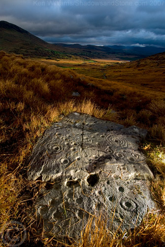
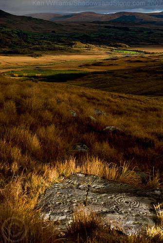
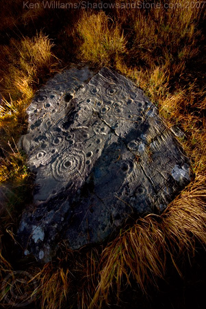
Derrynablaha
Derrynablaha 11
Cup and Ring Marks / Rock Art
Derrynablaha 11 (Cup and Ring Marks / Rock Art) on The Modern Antiquarian, the UK & Ireland's most popular megalithic community website. 3 images, plus information on many more ancient sites nearby and across the UK & Ireland.
Image © Ken Williams/ShadowsandStone.com 2007
Nearest Town:
Sneem (13km SSW)
OS Ref (IE):
V762774 /
Sheet: 78
Latitude:
51° 56' 6.36" N
Longitude:
9° 48' 0.93" W
Added by
CianMcLiam
Images (3)
0 discussions
Start a topic
Show |
Hide
Web searches for Derrynablaha 11
Flickr
Google
Google Images
The Megalithic Portal
Bing
Stone Pages
Wikipedia
Show map
(inline Google Map)
- Sites within 20 km -
-
Derrynablaha 11 (0.1km WSW) (0 posts)
Derrynablaha 028 (0.33km E) (1 post)
Derrynablaha D (0.41km ENE) (2 posts)
Derrynablaha (0.41km ENE) (2 posts)
Derrynablaha F (0.5km ENE) (3 posts)
Derreeny 3 (0.63km ENE) (1 post)
Derreeny 2 (0.63km ENE) (1 post)
Derreeny 4 (0.63km ENE) (0 posts)
Derreeny 5 (0.67km ENE) (1 post)
Derrynablaha 6 (0.7km SSE) (2 posts)
Derrynablaha 5 (0.7km SSE) (4 posts)
Derreeny 1 (0.7km ENE) (1 post)
Derrynablaha 3 (0.73km SE) (2 posts)
Derrynablaha 10 (0.73km SE) (0 posts)
Derrynablaha 7 (0.86km ESE) (1 post)
Derryleagh (7.76km SW) (3 posts)
Tullakeel (8.92km SW) (4 posts)
Rossacoosane (9.45km E) (1 post)
Dromtine (11.76km SW) (4 posts)
Coomasaharn (15.11km W) (3 posts)
Uragh North (15.46km SE) (14 posts)
Uragh (15.62km SE) (38 posts)
Uragh West (15.69km SE) (12 posts)
Kenmare (15.92km E) (26 posts)
Kealduff (337) (16.2km W) (1 post)
Kealduff (334) (16.2km W) (1 post)
Kealduff (333) (16.25km W) (1 post)
Kealduff (331) (16.28km W) (4 posts)
Dromroe (16.64km ESE) (24 posts)
Drombohilly (16.81km SSE) (32 posts)
Lehid (16.83km SSE) (3 posts)
Lehid (16.86km SSE) (1 post)
Drombohilly Wedge Tomb (17.01km SSE) (2 posts)
Lehid (17.18km SSE) (2 posts)
Coolnaharagill Upper (18.02km WNW) (2 posts)
Dromatouk (19.63km E) (3 posts)
Dromatouk (19.63km E) (1 post)
Reenkilla (19.68km SSE) (5 posts)
Cashelkeelty SE (19.72km S) (13 posts)
Dromatouk (19.75km E) (22 posts)
Dromatouk (19.79km E) (10 posts)
Caherlehillan North (19.82km W) (3 posts)
Gortnagulla (19.82km W) (3 posts)
Cashelkeelty NW (19.83km S) (12 posts)
Toon (19.87km W) (6 posts)
Caherlehillan South (19.88km W) (4 posts)
Caherlehillan (19.9km W) (2 posts)
Dromatouk (19.91km E) (8 posts)
- Add -
-
Add news
Add an image
Add fieldnotes
Add folklore
Add miscellaneous
Add a link
-
Add a site
Add a nearby facility
Add an alternative name/spelling
Images
(click to view fullsize)
Add an image