Log in
|
Register
Home
Latest Posts
Forums
Maps
Help
Browse Sites
News
Blog
Contributors
The Books
Select
-
Belgium
Denmark
Eire
France
Greece
Italy
The Netherlands
Norway
Portugal
Republic of Malta
Spain
Sweden
Switzerland
United Kingdom
England
Southern England
Dorset
Heather Cottage
Round Barrow(s)
Heather Cottage (Round Barrow(s)) on The Modern Antiquarian, the UK & Ireland's most popular megalithic community website. 1 image, 1 fieldnote, plus information on many more ancient sites nearby and across the UK & Ireland.
Image © Mike Rowland 27/01/2008.
Nearest Town:
Lulworth (7km SSE)
OS Ref (GB):
SY813877 /
Sheet: 194
Latitude:
50° 41' 16.94" N
Longitude:
2° 15' 53.11" W
Added by
formicaant
Images (1)
Fieldnotes (1)
0 discussions
Start a topic
Show |
Hide
Web searches for Heather Cottage
Flash Earth
Flickr
Google
Google Images
MAGIC
The Megalithic Portal
Bing
Stone Pages
Streetmap.co.uk
Wikipedia
Show map
(inline Google Map)
- Sites within 20 km -
-
Whitcombe Vale (0.82km WSW) (4 posts)
Old Knowle (1.4km W) (10 posts)
Blacknoll Hill (1.52km SSW) (7 posts)
Drove Hill (1.73km SW) (5 posts)
Tadnoll Barrow (2.16km WSW) (3 posts)
Turner's Puddle Heath (3.74km NNE) (3 posts)
Woodman's Cross (4.02km E) (2 posts)
Dead Woman's Stone (4.04km N) (1 post)
Five Marys (4.18km SW) (14 posts)
Chaldon Herring (4.58km SSW) (3 posts)
Throop Clump (4.85km N) (3 posts)
Pallington Clump (4.91km NW) (14 posts)
Lord's Barrow (5.08km SW) (4 posts)
Warren Heath (5.19km NE) (2 posts)
Coombe Heath (5.8km ESE) (10 posts)
Baylea Farm Barrow (5.84km E) (4 posts)
Bush Barrow (Lulworth) (5.9km S) (3 posts)
Owermoigne Down (6.05km SW) (8 posts)
Round Pound (6.16km SSW) (3 posts)
End Barrow (6.31km NNE) (1 post)
Huck Barrow (6.37km W) (3 posts)
Wardstone Barrow (6.66km SSW) (2 posts)
Moigns Down (6.73km SW) (3 posts)
Black Hill (6.86km NNE) (11 posts)
Double Barrow (6.91km N) (4 posts)
Tolpuddle Ball (7.01km NNW) (2 posts)
Chaldon Down (7.15km SSW) (5 posts)
Yon Barrow (7.28km NE) (3 posts)
Five Barrow Hill (7.29km E) (4 posts)
Hambury Tout (7.4km SSE) (3 posts)
Bindon Hill (7.71km SE) (3 posts)
Boswell's Plantation (7.72km W) (3 posts)
Fryer Mayne (7.88km WSW) (2 posts)
Water Barrows (7.93km ESE) (1 post)
Poxwell Cairn Circle (7.97km WSW) (10 posts)
Ferny Barrows (8.07km ESE) (4 posts)
South Down (8.15km SW) (5 posts)
Stand Barrow (8.18km NNE) (1 post)
Woodbury Hill (8.2km NNE) (10 posts)
Weatherby Castle (8.52km NNW) (23 posts)
Thorn Barrow (8.55km ESE) (3 posts)
Puddletown Forest (8.66km WNW) (3 posts)
Sandy Barrow (West Stafford) (8.67km W) (2 posts)
Povington Barrow (8.72km ESE) (1 post)
Roke Down (8.78km N) (3 posts)
Worgret Heath (8.8km E) (7 posts)
Flower's Barrow (8.87km ESE) (29 posts)
The Rainbarrows (8.97km W) (11 posts)
Cowleaze Barrows (9km NNW) (3 posts)
Mayne Stone Circle (9km WSW) (4 posts)
Woolsbarrow (9.22km ENE) (7 posts)
White Horse Hill (9.49km WSW) (4 posts)
Whitcombe Hill (9.51km W) (6 posts)
Rawles Barrow (9.56km NNE) (1 post)
Bere Down (9.63km N) (8 posts)
Hawke Barrow (9.63km NNE) (1 post)
Sandy Barrow (9.7km WSW) (3 posts)
Muddox Barrow (9.71km NNE) (1 post)
Goggin's Barrow (9.82km SW) (3 posts)
Bolton's Barrow (9.89km NNE) (1 post)
The Seven Barrows (9.92km ENE) (7 posts)
Whitcombe Barn (10.28km WSW) (4 posts)
Drinking Barrow (10.41km E) (1 post)
Three Lords Barrow (10.54km E) (1 post)
Mount Pleasant (10.6km W) (4 posts)
Bloxworth Down (10.64km NE) (6 posts)
East Hill Barrows (10.75km WSW) (19 posts)
Conquer Barrow (10.79km W) (4 posts)
King's Barrow (10.85km E) (1 post)
West Hill Barrows (11.17km WSW) (5 posts)
Flagstones (11.18km W) (4 posts)
Deverel Barrow (11.31km N) (22 posts)
Icen Barrow (11.51km E) (1 post)
Conygar Hill (11.52km W) (10 posts)
Came Wood Long Barrow (11.54km WSW) (6 posts)
Came Wood (11.57km WSW) (21 posts)
Broadmayne Bank Barrow (11.57km WSW) (36 posts)
Culliford Tree Barrow (11.59km WSW) (9 posts)
Bestwall Quarry (11.66km ENE) (2 posts)
Creech Barrow (12.04km E) (2 posts)
Waterston Ridge (12.3km WNW) (4 posts)
Stone Hill Down (12.31km E) (3 posts)
Chalbury (12.39km WSW) (25 posts)
Dorchester Palisaded Enclosure (12.4km W) (4 posts)
Fidler's Green (12.45km W) (2 posts)
Maumbury Rings (12.45km W) (42 posts)
Bincombe Down (12.55km WSW) (43 posts)
Came Down Golf Club (12.64km WSW) (12 posts)
Bincombe Down (12.71km WSW) (4 posts)
Herringston Barrow (12.78km W) (3 posts)
Three Barrows (13km E) (2 posts)
The Harpstone (13.03km ESE) (11 posts)
Bulbury Camp (13.17km ENE) (4 posts)
Poundbury Hillfort (13.42km W) (34 posts)
Wolfeton Clump (13.86km W) (4 posts)
Knowle Hill (14.22km E) (6 posts)
Maiden Castle (Dorchester) (14.27km W) (76 posts)
Ridgeway Hill (14.51km WSW) (5 posts)
Lanceborough King Barrow (14.64km W) (12 posts)
Wood Hill (14.65km W) (2 posts)
Whitfield (14.65km W) (3 posts)
Maiden Castle Long Barrow (14.78km W) (4 posts)
Gould's Hill Barrows (14.88km WSW) (22 posts)
Bayard Farm (14.98km WSW) (1 post)
Whitfield Farm (14.98km W) (6 posts)
Giant’s Grave (15.06km NW) (2 posts)
Swyre Head (15.2km ESE) (5 posts)
Corfe Castle (15.52km E) (18 posts)
Clandon Barrow (15.7km W) (11 posts)
Ridge Hill (15.78km WSW) (15 posts)
Windsbatch (15.78km WSW) (4 posts)
Windmill Barrow (15.93km NE) (1 post)
Corfe Common (16.11km E) (11 posts)
Four Barrow Hill (16.15km W) (8 posts)
Purlands Farm (16.37km W) (7 posts)
Friar Waddon (16.8km WSW) (9 posts)
Lyscombe Hill (16.86km NW) (3 posts)
The Dorsetshire Gap (16.9km NW) (1 post)
Henbury Barrow (17.13km NE) (1 post)
Penn Hill (17.2km W) (11 posts)
Great Hill Barrows (17.25km WSW) (4 posts)
Grove Hill (17.25km W) (2 posts)
Nettlecombe Tout (17.38km NW) (8 posts)
Spetisbury Rings (17.54km NE) (17 posts)
Rew Lane (17.75km W) (4 posts)
Worth Matravers (17.91km E) (4 posts)
Red Barn (18.13km W) (2 posts)
Bul Barrow (18.26km NNW) (1 post)
Shapwick Barrow (18.33km NE) (3 posts)
Grimstone Down (18.47km W) (10 posts)
Rawlsbury (18.66km NNW) (44 posts)
Bronkham Hill (18.74km WSW) (21 posts)
Rempstone Stone Circle (18.98km E) (53 posts)
King Barrow (19.15km SW) (2 posts)
Pigeon House (19.15km W) (1 post)
Nine Barrows Down Long Barrow (19.17km E) (2 posts)
Nine Barrows Down (19.17km E) (22 posts)
Pound Hill (19.19km W) (3 posts)
Smacam Down (19.53km WNW) (1 post)
Saw Mills Stone Circles (19.54km SW) (7 posts)
Ibberton Hill (19.62km NNW) (2 posts)
West Godlingston Heath (19.8km E) (10 posts)
Winterbourne Steepleton Cromlech (19.93km W) (3 posts)
- Facilities within 20 km -
-
The Dorset County Museum (Museum: 12.5 km W)
Scott Arms Hotel (Pub: 16.5 km ESE)
Burnbake campsite (Camping Site: 18.8 km E)
- Add -
-
Add news
Add an image
Add fieldnotes
Add folklore
Add miscellaneous
Add a link
-
Add a site
Add a nearby facility
Add an alternative name/spelling
Images
(click to view fullsize)
Add an image
Fieldnotes
Add fieldnotes
A medium sized bowl barrow north of Whitcombe Vale and Blacknoll. There are a scattering of barrows in this area which may be a large cemetery. Some are on high ground and others are on the flats in between.
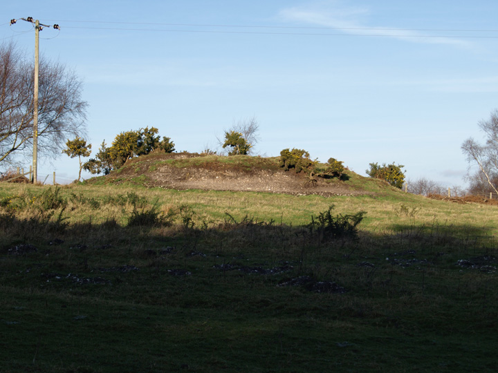
Comments (0)
|
Add a comment
|
Permalink
Posted by
formicaant
27th January 2008ce
Edited 6th June 2010ce