The Modern Antiquarian
Log in
|
Register
Home
Latest Posts
Forums
Maps
Help
Browse Sites
News
Blog
Contributors
The Books
Select
-
Belgium
Denmark
Eire
France
Germany
Greece
Italy
The Netherlands
Norway
Portugal
Republic of Malta
Spain
Sweden
Switzerland
United Kingdom
County Clare
Ballymihil
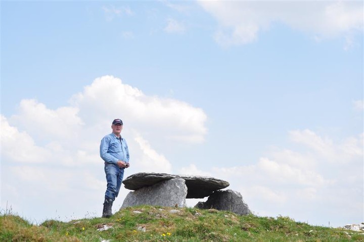
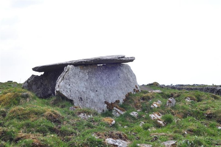
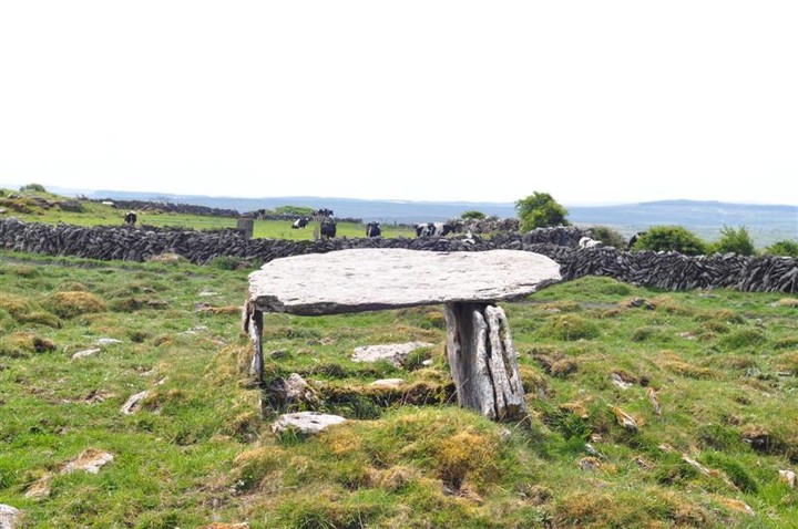
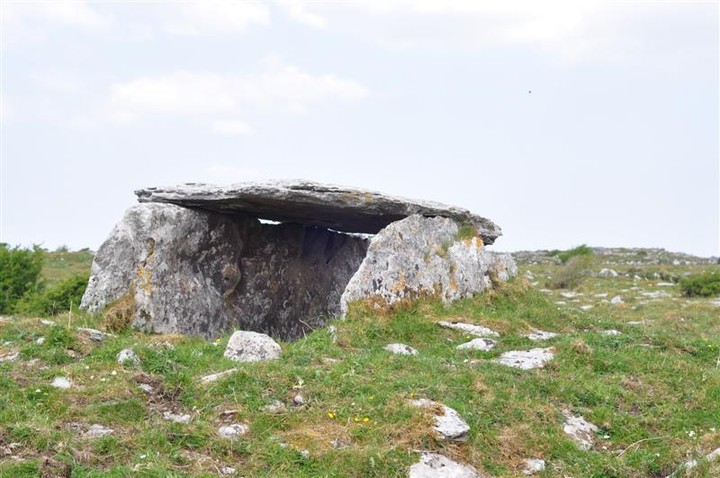
Wedge Tomb
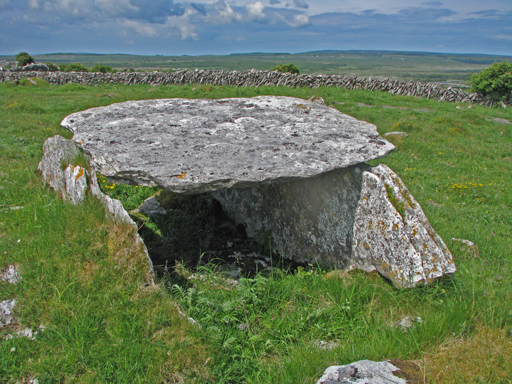
Ballymihil (Wedge Tomb) on The Modern Antiquarian, the UK & Ireland's most popular megalithic community website. 5 images, 1 fieldnote, 1 weblink, plus information on many more ancient sites nearby and across the UK & Ireland.
Image © C. Michael Hogan
Nearest Town:
Ballyvaghan (7km NNW)
OS Ref (IE):
M250012 /
Sheet: 51
Latitude:
53° 3' 22.4" N
Longitude:
9° 7' 7.31" W
Added by
C Michael Hogan
Images (5)
Fieldnotes (1)
Links (1)
0 discussions
Start a topic
Show |
Hide
Web searches for Ballymihil
Flickr
Google
Google Images
The Megalithic Portal
Bing
Stone Pages
Wikipedia
Show map
(inline Google Map)
- Sites within 20 km -
-
Poulaphuca (1.48km ENE) (7 posts)
Eanty More (1.55km E) (4 posts)
Poulnabrone (1.69km WSW) (66 posts)
Moheramoylan (Cl. 30) (1.91km S) (1 post)
Boloona (1.91km NNE) (4 posts)
Caherconnell (2.2km SW) (8 posts)
Gleninsheen (2.27km W) (10 posts)
Gleninsheen (2.4km WNW) (20 posts)
Rannagh West (2.44km ENE) (2 posts)
Meggagh (2.53km SE) (4 posts)
Berneens (2.54km WNW) (8 posts)
Baur South (2.78km WSW) (10 posts)
Baur North (2.78km WSW) (0 posts)
Baur South (2.93km WSW) (3 posts)
Poulawack Souterrain (2.96km SW) (6 posts)
Poulawack II (3.05km SSW) (5 posts)
Poulawack (3.18km SW) (13 posts)
Baur South (3.41km WSW) (0 posts)
Baur South (Cl. 26) (3.47km WSW) (6 posts)
Carran (3.9km S) (3 posts)
Cahermackirilla (4.07km SSE) (3 posts)
Fanyglavin (4.08km SSE) (12 posts)
Ballyallaban (4.13km WNW) (2 posts)
Lissylisheen (4.37km WSW) (2 posts)
An Ráth (4.51km WNW) (6 posts)
Iskancullin (4.64km SSW) (1 post)
Castletown (5.28km ESE) (4 posts)
Cahermore (5.29km WNW) (3 posts)
Tullycommon (Cl. 54) (5.3km ESE) (0 posts)
Cahermacnaghten (5.37km WSW) (5 posts)
Ballyganner North III (5.52km SSW) (7 posts)
Cahercommaun (5.67km ESE) (22 posts)
Tullycommon (5.89km ESE) (4 posts)
Creevagh (5.9km SE) (31 posts)
Coolnatullagh (6.02km ENE) (3 posts)
Coolnatullagh (6.06km ENE) (2 posts)
Coolnatullagh (6.18km ENE) (2 posts)
Coolnatullagh (6.2km ENE) (3 posts)
Slievenaglasha (6.28km ESE) (4 posts)
Ballyganner South II (6.32km SSW) (0 posts)
Ballyganner North (6.39km SSW) (6 posts)
Ballyganner North II (6.4km SSW) (6 posts)
Cappaghkennedy (6.62km E) (1 post)
Ballyganner South (6.64km SSW) (3 posts)
Commons North (Cl. 56) (6.88km SE) (4 posts)
Faunarooska (Cl. 5) (6.9km WNW) (4 posts)
Clooneen (7.12km S) (6 posts)
Leana (Cl. 57) (7.27km SE) (3 posts)
Commons North (Cl. 65) (7.34km SSE) (0 posts)
Faunarooska (Cl. 4) (7.41km W) (2 posts)
Leana (Cl. 68) (7.41km SE) (16 posts)
Ballyganner South (7.42km SSW) (6 posts)
Faunarooska (Cl. 3) (7.49km W) (2 posts)
Leana (7.53km SE) (7 posts)
Parknabinnia (Cl. 66) (7.62km SSE) (11 posts)
Leana (7.63km SE) (2 posts)
Turlough Hill/Knockycallanan (7.69km NE) (7 posts)
Parknabinnia (Cl. 153) (7.8km SSE) (7 posts)
Parknabinnia (Cl. 59) (7.83km SSE) (0 posts)
Turlough Hill/Knockycallanan (7.83km NE) (11 posts)
Parknabinnia (Cl. 67) (7.83km SSE) (27 posts)
Parknabinnia (Cl. 60) (7.92km SSE) (0 posts)
Parknabinnia (Cl. 61) (7.93km SSE) (4 posts)
Parknabinnia (Cl. 62) (8.03km SSE) (0 posts)
Parknabinnia (8.04km SSE) (3 posts)
Ballykinvarga (8.04km SW) (0 posts)
Parknabinnia (Cl. 69) (8.06km SSE) (3 posts)
Derrynavahagh (8.19km W) (12 posts)
Slievecarran (8.53km ENE) (0 posts)
Ballycasheen (8.79km S) (2 posts)
Lissateeaun (10.4km WSW) (1 post)
Gleninagh North (10.8km WNW) (5 posts)
Ballyelly Hut Site (10.83km W) (4 posts)
Ballyelly (10.83km W) (6 posts)
Aughinish (12.34km N) (7 posts)
Ballytarsna (12.69km SW) (2 posts)
Caherdooneerish (13.7km WNW) (4 posts)
Doorus (14.48km NE) (4 posts)
Curraghadoo (15.41km SW) (4 posts)
Moyree Commons (16.51km ESE) (10 posts)
Ballynastaig (17.37km ENE) (0 posts)
Ballynastaig (17.42km ENE) (0 posts)
Knockstoolery (17.78km WSW) (2 posts)
Crannagh (18.05km ENE) (0 posts)
Crannagh (18.05km ENE) (10 posts)
Ballynastaig (18.24km ENE) (10 posts)
Ballynastaig Souterrain (18.24km ENE) (0 posts)
Teergonean (18.29km WSW) (11 posts)
Teergonean (18.33km WSW) (5 posts)
Doolin (19.02km WSW) (3 posts)
Doolin (19.03km WSW) (1 post)
Doolin (19.08km WSW) (2 posts)
Doolin Stone Axe Production Site (19.14km WSW) (2 posts)
Killian (19.17km ESE) (2 posts)
Caherphuca (19.68km ESE) (8 posts)
- Add -
-
Add news
Add an image
Add fieldnotes
Add folklore
Add miscellaneous
Add a link
-
Add a site
Add a nearby facility
Add an alternative name/spelling
Images
(click to view fullsize)
Add an image
Fieldnotes
Add fieldnotes
This lies just off a track accessed next to an abandoned farmhouse on the the main road, make sure to close all the gates, if you continue another 1.5km to the end of the track its reasonably easy to find Boloona Wedge tomb about 500m distant
Comments (0)
|
Add a comment
|
Permalink
Posted by
bogman
29th May 2012ce
Links
Add a link
Clare County Library: Ballymihil Wedge Tomb
Photograph of Ballymihil Wedge Tomb.
Comments (0)
|
Add a comment
|
Permalink
Posted by
C Michael Hogan
14th April 2008ce
Edited 14th April 2008ce

 Posted by bogman
 Posted by C Michael Hogan