The Modern Antiquarian
Log in
|
Register
Home
Latest Posts
Forums
Maps
Help
Browse Sites
News
Blog
Contributors
The Books
Select
-
Belgium
Denmark
Eire
France
Germany
Greece
Italy
The Netherlands
Norway
Portugal
Republic of Malta
Spain
Sweden
Switzerland
United Kingdom
County Limerick
Carrignacaubeen
Standing Stone / Menhir
Carrignacaubeen (Standing Stone / Menhir) on The Modern Antiquarian, the UK & Ireland's most popular megalithic community website. 1 image, 1 fieldnote, plus information on many more ancient sites nearby and across the UK & Ireland.
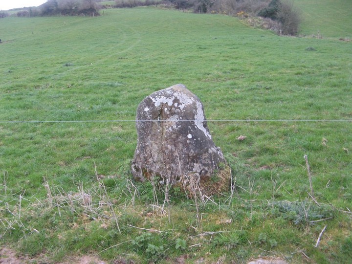
Image © Bawn79 © 2008
Nearest Town:
Kilfinnane (5km SSW)
OS Ref (IE):
R711266 /
Sheet: 73
Latitude:
52° 23' 25.07" N
Longitude:
8° 25' 28.37" W
Added by
bawn79
Images (1)
Fieldnotes (1)
0 discussions
Start a topic
Show |
Hide
Web searches for Carrignacaubeen
Flickr
Google
Google Images
The Megalithic Portal
Bing
Stone Pages
Wikipedia
Show map
(inline Google Map)
- Sites within 20 km -
-
Cush (1.22km SW) (1 post)
Cush (1.58km SW) (5 posts)
Cloghast (1.97km ESE) (5 posts)
Ballyriggin (2.37km SSW) (2 posts)
Ballyfroota (3.04km E) (3 posts)
Ballyriggin (3.05km SSW) (3 posts)
Carraigapuckaun (3.11km SSE) (2 posts)
Ballingarry (3.26km E) (1 post)
Kilfinnane (3.88km SW) (4 posts)
Ballingarry (3.95km E) (3 posts)
Ladys Well (4.56km SSW) (3 posts)
Clogher Hill (4.57km NNE) (2 posts)
Kilfinnane (4.77km SW) (2 posts)
Ballinvana (4.79km WNW) (2 posts)
Elton (4.91km NW) (6 posts)
Ballinscaula (5.58km WNW) (6 posts)
Ballinscaula (5.58km WNW) (2 posts)
Ballygeagoge (5.72km SW) (1 post)
Ballinlyna Lower (6.29km SW) (1 post)
Ballygeagoge (6.43km SW) (0 posts)
Lissard (6.46km ENE) (3 posts)
Ballygeagoge (6.56km SW) (1 post)
Mortlestown Hill (6.63km SW) (5 posts)
Lissard (7km ENE) (10 posts)
Duntryleague (7.01km ENE) (32 posts)
Duntryleague Cairn (7.01km ENE) (1 post)
Bulgadenhall (7.91km W) (1 post)
Rathanny (7.97km NNW) (7 posts)
Coolalough (8.09km NNW) (2 posts)
Gotoon (8.42km NNW) (2 posts)
Darragh Graveyard (8.55km S) (3 posts)
Coolalough (8.87km N) (5 posts)
Gorteennacreeagh (8.91km NW) (2 posts)
Coolalough (9.09km N) (2 posts)
Ardpatrick (9.3km SW) (5 posts)
Hospital (9.91km N) (2 posts)
Cloonyconry More (10.2km NNE) (4 posts)
Labbamologga Middle (10.29km SE) (3 posts)
Labbamologga Middle (10.29km SE) (4 posts)
Labbamologga Middle (10.37km SE) (2 posts)
Seefin Hill (10.38km SW) (5 posts)
Cnoc Aine (10.45km NW) (6 posts)
Cnoc Aine (10.46km NW) (1 post)
Cnoc Aine (10.48km NW) (7 posts)
Cnoc Aine (10.6km NW) (3 posts)
Castlegale (10.63km SSE) (3 posts)
Castlegale (10.63km SSE) (2 posts)
Castlegale (10.63km SSE) (3 posts)
Cnoc Aine (10.81km NW) (2 posts)
Castlefarm (11.07km NNW) (4 posts)
Lodge (11.19km N) (4 posts)
Rearnadargh (11.64km S) (2 posts)
Tynacocka (11.79km WNW) (2 posts)
Corderry (11.89km ENE) (8 posts)
Cloghaunainey (11.99km NNW) (1 post)
Ballynamona (11.99km NNW) (4 posts)
Mountrussel (12.23km SW) (2 posts)
Cromwell Hill (12.43km N) (7 posts)
Bruff (12.5km WNW) (3 posts)
Baunteen (12.51km E) (3 posts)
Baunteen (12.61km E) (1 post)
Derrylahan Hill (12.66km ESE) (2 posts)
Grillagh (12.8km NW) (0 posts)
Lattin (13.04km NE) (3 posts)
Glenbane (13.04km NE) (1 post)
Temple Hill (13.16km E) (6 posts)
Ballyarthur (13.41km ESE) (2 posts)
Lattin (13.67km NE) (3 posts)
Shrough (13.74km ENE) (16 posts)
Ballyconry (14.24km NE) (6 posts)
Knockroe (14.34km N) (1 post)
Ballyconry (14.38km NE) (2 posts)
Knocktwo (14.39km W) (3 posts)
Knocksouna (14.55km W) (1 post)
Loughgur (14.87km NW) (0 posts)
Moohane (14.98km NW) (4 posts)
Black Sow’s Bed (15.01km NW) (6 posts)
Rootiagh (15.09km NNW) (1 post)
Ballinculloo (15.18km W) (4 posts)
Longstone (15.22km NE) (1 post)
Longstone (15.22km NE) (8 posts)
Longstone (15.22km NE) (3 posts)
Rootiagh (15.24km NNW) (3 posts)
Carraig Aille (15.31km NW) (4 posts)
Carraig Aille (15.31km NW) (7 posts)
Knockroe (15.48km NW) (3 posts)
Knockadoon Circles A + B (15.49km NW) (1 post)
Sarsfields Rock (15.53km NNE) (3 posts)
Knockadoon Circle K (15.63km NW) (5 posts)
Knockadoon (15.63km NW) (1 post)
Lough Gur P (15.66km NW) (1 post)
Old Hags Chair (15.72km NW) (2 posts)
Lough Gur O (15.72km NW) (8 posts)
The Stone Of The Tree (15.82km NW) (6 posts)
Grange Lios (15.96km NW) (9 posts)
Entrance to Tir Na Og (15.99km NW) (3 posts)
Lough Gur Wedge Tomb (16.03km NW) (26 posts)
Grange / Lios, Lough Gur (16.03km NW) (87 posts)
Lough Gur C (16.12km NW) (17 posts)
Lough Gur D (16.12km NW) (6 posts)
The Pillar Stone (16.12km NW) (8 posts)
Rockbarton (16.19km WNW) (3 posts)
Knockfennel (16.29km NW) (2 posts)
Knockfennel (16.34km NW) (4 posts)
Knockfennel (16.44km NW) (3 posts)
Knockfennel North (16.57km NW) (4 posts)
Harps of Cliu (16.89km E) (5 posts)
Ballingoola A (17.41km NW) (2 posts)
Gortavoher (17.45km ENE) (1 post)
Ballingoola B (17.54km NW) (1 post)
Clonpet (17.65km ENE) (1 post)
Ballynilard (17.65km ENE) (4 posts)
Ballingoola (17.69km NW) (1 post)
Ballingoola C (17.72km NW) (1 post)
Ballingoola D (18km NW) (0 posts)
Ballindangan (18.13km SE) (2 posts)
Ballingoola E (18.19km NW) (1 post)
Rock an Tarbh (18.27km ENE) (3 posts)
Cnoc Greine (18.43km N) (3 posts)
Gortavoher (North) (18.47km ENE) (4 posts)
Nutgrove (18.69km SE) (4 posts)
Longstone (18.91km N) (2 posts)
Knocsefin (19.02km N) (3 posts)
Knocksefin (19.7km NNE) (1 post)
- Add -
-
Add news
Add an image
Add fieldnotes
Add folklore
Add miscellaneous
Add a link
-
Add a site
Add a nearby facility
Add an alternative name/spelling
Images
(click to view fullsize)
Add an image
Fieldnotes
Add fieldnotes
This standing stone is about 2 fields in from the road and trickier to get to than the map suggests.
It is pretty non-descript maybe about 0.5m high just alongside a farm track.
Comments (0)
|
Add a comment
|
Permalink
Posted by
bawn79
23rd April 2008ce