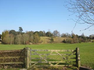
Looking at the map this site appears to be very easy to access; being right next to a minor road just off junction 16 of the M5. The reality is quite different.
The road is bordered by quite large, posh looking houses – no chance of seeing anything from here.
I had planned to walk up the side road which leads to the houses (and the centre of the Hillfort) but was greeted with ‘Private road – residents only access’ signs which put me off.
Basically, these houses have been built in the middle of the Hillfort so I don’t know how much is actually left to see? The O/S map shows ramparts to the north and west but as I said there was no way to check for myself.
This camp is situated upon the brow of a hill, next the Severn, so as to command an extensive view of that river, and every thing passing upon it. 'Tis supposed to be Saxon, but no mention is made of it in the Chronicle, nor by any of the antient writers.
Tradition will have it to be the work of Offa, king of the Mercians, whose coffin the common people think was dug out of a tumulus, at Over, in this parish, in the year 1650, but Florilegius affirms, that he was buried at Bedford, whose authority, in this matter, ought to be preferred to vulgar opinion...
From 'A New History of Gloucestershire' by Samuel Rudder, 1779 (p222).
Almondsbury is said to have derived its name from being the burying-place of Alemond, a Saxon Prince, and father of King Egbert; but more probably from a burg, or fortification, constructed by him, and the remains of which are yet visible on an eminence to the eastward of the Church. The traces of a Camp are also discoverable round the brow of Knowle Hill, within the area of which is the Manor-House [..].
From 'The Beauties of England and Wales' v5 (1810).
Witt's 1880s Handbook calls it 'Knole Park Camp' :
This stands on a steep hill in the parish of Almondsbuary, six miles north of Bristol. Though conforming to the shape of the ground, the camp was nearly oval. The defences consisted of a mound and two ditches, but these have been mostly destroyed by buildings, a large house having sprung up within the area of the ancient camp. There seems to have been an entrance at the north-east end, but nothing very definite can now be said on the subject. The views from this position are very fine, and embrace both shores of the Severn and the district of the Silures.

 Posted by Rhiannon