The Modern Antiquarian
Log in
|
Register
Home
Latest Posts
Forums
Maps
Help
Browse Sites
News
Blog
Contributors
The Books
Select
-
Belgium
Denmark
Eire
France
Germany
Greece
Italy
The Netherlands
Norway
Portugal
Republic of Malta
Spain
Sweden
Switzerland
United Kingdom
Scotland
Aberdeenshire
Avochie Stone
Avochie
Cup Marked Stone
Avochie (Cup Marked Stone) on The Modern Antiquarian, the UK & Ireland's most popular megalithic community website. 3 images, 1 fieldnote, plus information on many more ancient sites nearby and across the UK & Ireland.
Image © drew/amj
Nearest Town:
Huntly (8km S)
OS Ref (GB):
NJ541468 /
Sheet: 29
Latitude:
57° 30' 32.86" N
Longitude:
2° 45' 58.17" W
Added by
drewbhoy
Images (3)
Fieldnotes (1)
0 discussions
Start a topic
Show |
Hide
Web searches for Avochie
Flickr
Google
Google Images
MAGIC
The Megalithic Portal
Bing
Stone Pages
Streetmap.co.uk
Wikipedia
Show map
(inline Google Map)
- Sites within 20 km -
-
Avochie South 3 (0.13km SSE) (6 posts)
Avochie Stone (0.2km NNW) (16 posts)
Avochie South 2 (0.24km SSW) (4 posts)
Avochie South 1 (0.26km SSW) (8 posts)
Hill Of Avochie (0.26km SE) (8 posts)
Arn Hill (1.56km SW) (15 posts)
Corskellie (1.89km ENE) (14 posts)
Rothiemay (2.14km NNE) (41 posts)
Cairn Of Beith (3.71km NE) (11 posts)
Hill Of Cairns 2 (4.63km NE) (5 posts)
Hill Of Cairns (4.7km NE) (4 posts)
Roddantree (4.99km SSW) (12 posts)
Cairnton (5.04km E) (10 posts)
Conjure Cairn (5.1km NNE) (10 posts)
Kemps Cairn (5.15km NNE) (5 posts)
Monk's Cairn (5.21km WNW) (9 posts)
Yonder Bognie (6.06km E) (19 posts)
St Marnan's Chair (6.53km ENE) (23 posts)
Battle Hill (6.84km SSE) (8 posts)
Marnoch Lodge (6.87km ENE) (9 posts)
Huntly (7.06km S) (9 posts)
Oakenknowes (7.12km NW) (8 posts)
White Cow (7.22km ENE) (4 posts)
Bellman's Wood (7.23km ENE) (8 posts)
Newtongarry Hill (7.37km ESE) (7 posts)
Wether Hill (7.38km NNE) (3 posts)
Battlefield (7.55km NNE) (4 posts)
Knock Hill (7.59km NNW) (17 posts)
Whitehill (7.65km NNW) (5 posts)
King's Chair (7.85km NNE) (4 posts)
Frendraught (7.95km E) (13 posts)
Hill Of Milleath (8.23km WSW) (7 posts)
Knock Hill (8.29km NNW) (24 posts)
Raich (8.31km E) (22 posts)
White Stone (8.43km NNW) (6 posts)
Cleanhill (8.69km ENE) (8 posts)
Black Hill (8.72km WSW) (5 posts)
Cloven Stone (8.97km NNW) (4 posts)
Thorax (9.06km NNE) (10 posts)
Garran Burn (9.26km SW) (11 posts)
Hill Of Backtack (9.27km WSW) (9 posts)
Clashmach Hill (9.31km SSW) (9 posts)
Clashmach (9.32km SSW) (10 posts)
Backtack (9.33km WSW) (5 posts)
Bar Hill (9.66km SW) (9 posts)
Fullerton/Bogcoup (9.77km E) (3 posts)
Hill of Backside (9.87km SW) (10 posts)
Allrick Hill (9.9km SW) (8 posts)
Glenshee 1 (10.16km WSW) (6 posts)
Cairnborrow (10.26km WSW) (5 posts)
Newton Hill (10.28km WSW) (5 posts)
Stonyfield (10.35km SE) (13 posts)
Cairnborrow Lodge (10.37km WSW) (6 posts)
Glenshee 2 (10.67km WSW) (6 posts)
Glenshee 3 (10.79km WSW) (5 posts)
North Whiteley A (10.86km W) (4 posts)
North Whiteley B (11.02km W) (5 posts)
South Balnoon (11.06km E) (6 posts)
Auchaber (11.14km E) (5 posts)
Edintore (11.17km WSW) (3 posts)
Cairds Hill (11.21km WSW) (4 posts)
Westfolds (11.3km WSW) (7 posts)
Both Hill (11.34km WSW) (10 posts)
Norry Hill (11.49km WSW) (6 posts)
Aswanley Wood (11.62km SW) (9 posts)
Both Hill 2 (11.64km WSW) (8 posts)
Hill Of Janetstown (12.3km WSW) (5 posts)
Tam's Chamber (12.44km ENE) (8 posts)
Harestane, Feith Hill (12.62km E) (6 posts)
West Drachlaw (12.95km E) (13 posts)
Backhill of Drachlaw (13.16km E) (20 posts)
Hill Of Janetstown 2/3 (13.2km WSW) (6 posts)
Carlin Stone (13.25km E) (29 posts)
Newton Of Fortrie (13.41km E) (4 posts)
Hill Of Laithers (13.41km ENE) (5 posts)
Crofts of Shielburn (13.46km E) (11 posts)
Logie Newton (14.05km E) (8 posts)
Whitehill Wood, Cairn Ennit (14.14km ENE) (5 posts)
The Reesk (14.23km SW) (6 posts)
Killiesmont (14.44km W) (2 posts)
Ten Rood Wood (14.48km WSW) (8 posts)
Nether Dumeath (14.64km SW) (13 posts)
Pitglassie (14.84km E) (14 posts)
King's Cairn (15.34km WNW) (7 posts)
Upper Third (15.48km E) (18 posts)
North Burreldales (15.61km ENE) (8 posts)
St Brandan's Stanes (15.63km NNE) (18 posts)
Lenchie (15.99km SE) (4 posts)
Tor Sliasg (16.01km WNW) (11 posts)
Forglen (16.2km ENE) (6 posts)
Mains of Hatton (16.32km E) (16 posts)
Cairnhead Wood (16.32km SW) (6 posts)
Drumel Stone (16.35km S) (3 posts)
Midtown Of Pitglassie (16.39km E) (8 posts)
Midtown Of Pitglassie 2 (16.46km E) (4 posts)
The Candy Stone (16.49km S) (5 posts)
Corrydown (16.7km E) (16 posts)
Newton Of Wardhouse (16.72km SSE) (8 posts)
Wardhouse (16.78km SSE) (5 posts)
Newton Of Wardhouse Farm (16.79km SE) (3 posts)
Hillside (16.86km N) (5 posts)
Colpy (17.23km ESE) (2 posts)
Durn Hill (17.26km N) (9 posts)
Barbara's Hillock (17.37km ENE) (8 posts)
Leith Hall Policies (17.45km S) (9 posts)
Culsalmond (17.76km ESE) (4 posts)
Meikle Hill (17.76km WNW) (8 posts)
Candle Hill (17.83km SE) (35 posts)
Craig Dorney (17.84km SW) (32 posts)
Davie's Castle (18.03km NW) (14 posts)
Fallow Hill (18.03km SSE) (6 posts)
Fallow Cairn (18.05km SSE) (4 posts)
Fallow Hill (18.1km ESE) (5 posts)
Mummer's Reive (18.14km ESE) (6 posts)
Carlinkist Cairn (18.17km ENE) (7 posts)
Hill Of Alvah (18.23km NE) (4 posts)
Wormy Hillock (18.37km SW) (16 posts)
Tap o' Noth (18.37km SSW) (73 posts)
Clochmaloo (18.65km SSW) (5 posts)
Stirling Cairn (18.72km NE) (7 posts)
Giant's Stone (18.75km SSW) (12 posts)
Finglenny (18.76km SSW) (11 posts)
Hill Of Old Merdrum (18.88km SSW) (3 posts)
Ardlair (18.9km SSE) (35 posts)
Sandend (18.97km N) (4 posts)
Stonehead (19.06km SE) (34 posts)
Newseat 2 (19.11km SSW) (4 posts)
South Sandlaw (19.12km NE) (3 posts)
Newseat (19.13km SSW) (9 posts)
Moss Hill Plantation (19.14km NW) (5 posts)
Hill of Old Merdrum (19.16km SSW) (3 posts)
Rumfold (19.2km SSW) (3 posts)
Chalmers Slack (19.2km NW) (5 posts)
Mellenside (19.23km ESE) (8 posts)
Inschfield (19.24km SE) (12 posts)
Mill of Noth (19.34km S) (10 posts)
Foulford Bridge (19.39km NW) (4 posts)
Dunnydeer Farm (19.48km SE) (21 posts)
Dunnydeer (19.7km SE) (6 posts)
Hill Of Rothmaise (19.7km ESE) (7 posts)
Clatt Bankhead (19.8km S) (6 posts)
Corrstones (19.81km S) (27 posts)
Dunnideer (19.87km SE) (31 posts)
Woodside, Delgaty (19.92km ENE) (5 posts)
- Add -
-
Add news
Add an image
Add fieldnotes
Add folklore
Add miscellaneous
Add a link
-
Add a site
Add a nearby facility
Add an alternative name/spelling
Images
(click to view fullsize)
Add an image
Fieldnotes
Add fieldnotes
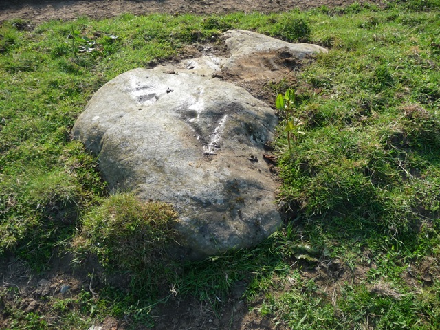
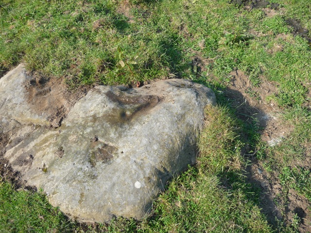
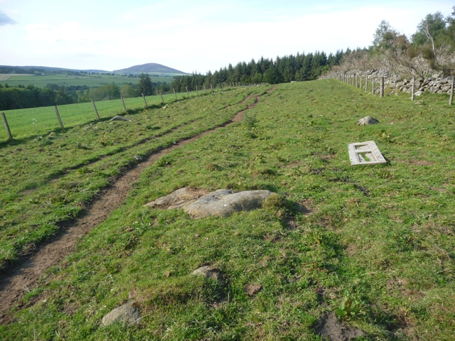
This rock, found by K. Sabine, has 3 cup marks. One clearly visible and two well weathered efforts. Head towards the famous rock, this stone is 20 yards from the track.
Visited 10/06/2011.
Comments (0)
|
Add a comment
|
Permalink
Posted by
drewbhoy
13th June 2011ce