The Modern Antiquarian
Log in
|
Register
Home
Latest Posts
Forums
Maps
Help
Browse Sites
News
Blog
Contributors
The Books
Select
-
Belgium
Denmark
Eire
France
Germany
Greece
Italy
The Netherlands
Norway
Portugal
Republic of Malta
Spain
Sweden
Switzerland
United Kingdom
County Cork
Coolcoulaghta
Burial Chamber
Coolcoulaghta (Burial Chamber) on The Modern Antiquarian, the UK & Ireland's most popular megalithic community website. 4 images, 1 fieldnote, plus information on many more ancient sites nearby and across the UK & Ireland.
Image © Michael Mitchell
Nearest Town:
Durrus (2km NNW)
OS Ref (IE):
V952403 /
Sheets: 85, 88
Latitude:
51° 36' 20.34" N
Longitude:
9° 30' 46.42" W
Added by
Meic
Images (4)
Fieldnotes (1)
0 discussions
Start a topic
Show |
Hide
Web searches for Coolcoulaghta
Flickr
Google
Google Images
The Megalithic Portal
Bing
Stone Pages
Wikipedia
Show map
(inline Google Map)
- Sites within 20 km -
-
Mount Corrin (1.64km SW) (7 posts)
Dunbeacon (2.23km WSW) (6 posts)
Dunbeacon (2.72km WSW) (20 posts)
Rathruane Beg (3.28km SE) (4 posts)
Ballycommane (4.07km NE) (3 posts)
Ballycommane (4.07km NE) (2 posts)
Rathruane More (4.07km SE) (6 posts)
Rooska East (4.97km NNW) (6 posts)
Maulinward (5.23km NE) (6 posts)
Maulinward (5.23km NE) (6 posts)
Parkana (5.94km NE) (3 posts)
Keilnascarta SE (6.22km NE) (5 posts)
Keilnascarta (6.3km NE) (5 posts)
Keilnascarta NW (6.37km NE) (6 posts)
Ballybane West NW (6.69km E) (5 posts)
Ballybane (The Rock of the Rings) (6.77km E) (4 posts)
Dromclogh (7.14km N) (5 posts)
Rathcool (7.16km S) (6 posts)
Caherogullane (7.47km NE) (5 posts)
Scartbaun (7.51km NE) (1 post)
Beach (7.58km N) (1 post)
Kilbronoge (7.7km SSE) (12 posts)
Cappaghnacallee (7.8km SE) (1 post)
Derreengreanagh (7.9km NE) (11 posts)
Scartbaun (8.1km NE) (5 posts)
Dromourneen (8.32km ENE) (2 posts)
Cappaghmore (8.36km E) (6 posts)
Baurgorm SW (8.49km NE) (1 post)
Cullomane West (8.56km NE) (10 posts)
Murrahin North (8.56km E) (13 posts)
Skull Stone (8.68km S) (5 posts)
Murrahin North (8.83km E) (8 posts)
Gorteanish (9.18km WSW) (14 posts)
Knocknaveagh (9.27km NE) (4 posts)
Lissaclarig West (9.47km E) (7 posts)
Cullomane East (9.57km ENE) (7 posts)
Cullomane East (9.57km ENE) (3 posts)
Cullomane East (9.57km ENE) (6 posts)
Baurgorm (9.67km NE) (11 posts)
Cullomane East (9.71km ENE) (3 posts)
Cullomane (9.76km ENE) (10 posts)
Cullomane East (9.8km ENE) (4 posts)
Trawlebane 2 (10.66km NE) (5 posts)
Inchybegga (11.08km ENE) (2 posts)
Trawlebane 1 (11.56km NE) (7 posts)
Trawlebane (11.68km NE) (15 posts)
Lyre (11.71km E) (6 posts)
Dunmanus (11.89km SW) (3 posts)
Foherlagh (11.91km E) (8 posts)
Dromore School (11.95km ENE) (3 posts)
Hollyhill (12km E) (5 posts)
Lisheen Lower (12.07km ESE) (4 posts)
Arderawinny (12.28km SW) (10 posts)
Farranamanagh (12.37km WSW) (2 posts)
Skeagh (12.54km E) (3 posts)
Farranamanagh (12.79km WSW) (6 posts)
Dunmanus East (12.98km SW) (3 posts)
Gortnascreeny (13.13km ENE) (5 posts)
Kilcrohane (13.39km WSW) (9 posts)
Toormore (13.54km SW) (15 posts)
Altar (13.7km SW) (19 posts)
Killenough (13.98km WNW) (5 posts)
Glanbannoo Upper (14.11km NE) (7 posts)
Glanbannoo Upper (14.25km NE) (3 posts)
Bawnishall (14.42km E) (3 posts)
Shandrum Beg (14.57km NNE) (5 posts)
Cloghboola (14.75km E) (5 posts)
Inishbeg (14.8km ESE) (5 posts)
Peakeen (14.82km WSW) (6 posts)
Leitrim Beg (14.89km WNW) (21 posts)
Cloonygorman (14.89km NE) (3 posts)
Toughraheen (15.15km NE) (1 post)
Cappanaboul (15.25km NNE) (7 posts)
Lissangle (15.57km ENE) (5 posts)
Ballynahowen (15.66km WNW) (15 posts)
Abbeystrowry (16.13km E) (5 posts)
Drumlave (16.27km WNW) (11 posts)
Cappaleigh North (16.47km WNW) (4 posts)
Derryarkane (16.68km NE) (0 posts)
Mill Little (16.71km N) (28 posts)
Inis Earcain (Sherkin Island) (16.74km SE) (1 post)
Ballydivlin (16.78km SW) (4 posts)
Inis Earcain (Sherkin Island) (16.8km SE) (2 posts)
Kildromalive (16.82km WNW) (5 posts)
Canrooska (17.56km NNW) (25 posts)
Breeny More (17.8km NE) (30 posts)
Kilcaskan (17.94km WNW) (5 posts)
Ballymacrown (18.01km ESE) (6 posts)
Coolnagarrane (18.03km E) (2 posts)
Kilickaforavane (18.21km SSE) (2 posts)
Barnabah (18.26km ESE) (2 posts)
Kealkil (18.32km NE) (45 posts)
Ardrah (18.41km NE) (20 posts)
Caherurlagh (18.41km WSW) (6 posts)
Baurnahulla (19.08km ENE) (3 posts)
Coomgira (19.17km W) (6 posts)
Gortnacowly (19.47km NE) (15 posts)
Garranes North (19.59km ENE) (6 posts)
Crossterry East (19.64km NNW) (7 posts)
Barraboy Mountain S (19.85km NNW) (9 posts)
Barraboy Mountain N (19.85km NNW) (6 posts)
- Add -
-
Add news
Add an image
Add fieldnotes
Add folklore
Add miscellaneous
Add a link
-
Add a site
Add a nearby facility
Add an alternative name/spelling
Images
(click to view fullsize)
Add an image
Fieldnotes
Add fieldnotes
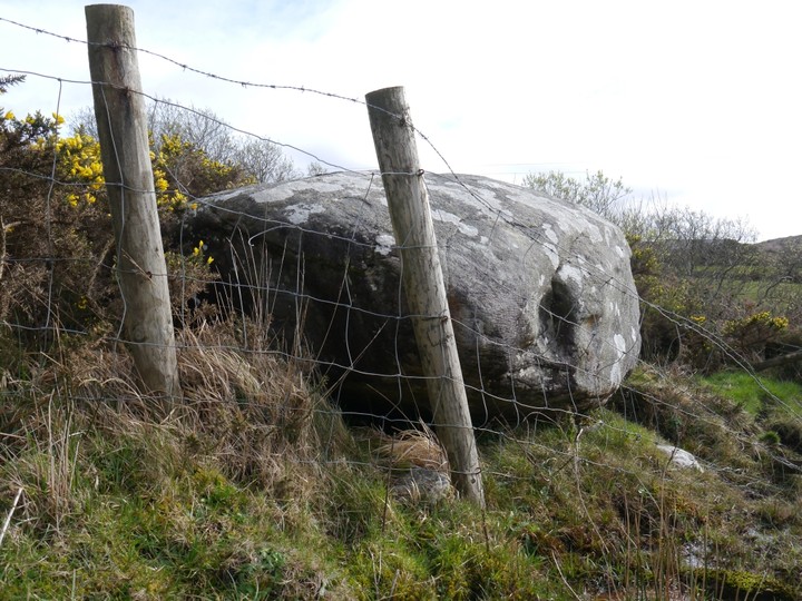
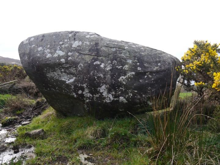
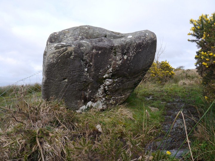
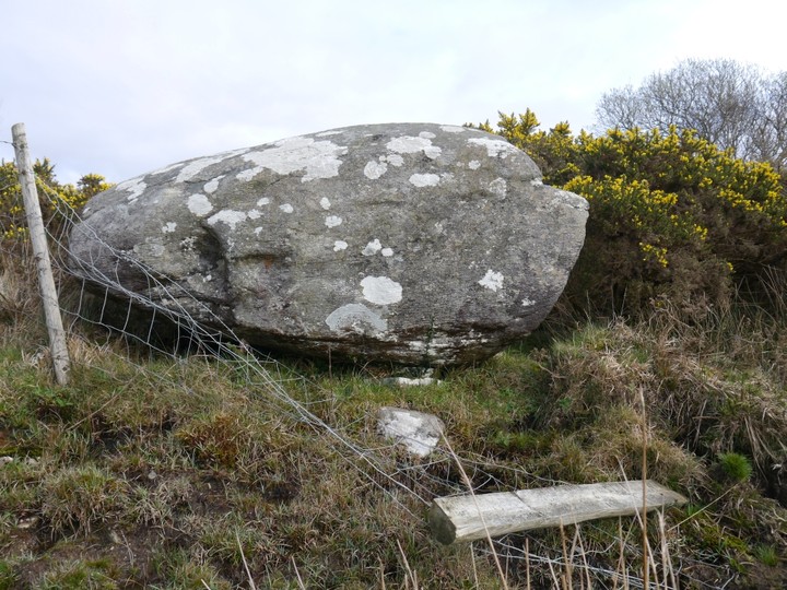
Nice boulder burial to the NNW of Mount Corrin. A fence which ran across it has been partially torn down. Two support stones are visible.
It's in a pretty boggy corner of the field I find out, as my foot sinks into the black smelly peaty goo.....
Comments (0)
|
Add a comment
|
Permalink
Posted by
Meic
10th March 2012ce

 Posted by Meic