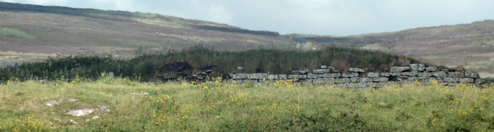
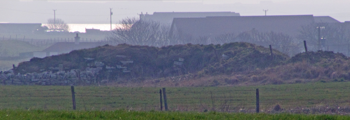
NMRS record no. HY31NW 38 at HY32321741 in an area also known as Noltland. From Noltland 'cattle land' Hedges suggests that the original name comes from Nolt+Clettr 'cattle rock'.but is unable to come up with anything in the vicinity that would have given rise to this name. I would suggest that perhaps the Vikings saw the broch mound as having been 'calved' by the burn. At the end of a long walk I wasn't up to making my way to the broch but made observations from various places. To see the interior good views can be had from the Howe road that runs beside the Harray Manse. Going back onto the main road I first saw the broch by looking straight across from the site of the Knowe of Brinnanea where the burn meets the road. I find it difficult to realise that I must have been looking directly at it several times previously. Eye unaided I would have seen it as simply a fieldwall of white stones like shiny pearl teeth. Admittedly there is such a wall beside it, but with camera and binoculars the stone is truly monumental, much bigger in size and more regular in shape.
The Nettletar/Netlater Broch was revealed in about 1860 when the Rev.Dr.Trail excavated a large mound some 200 yards south of the manse, and hard by the present course of the Burn of Nettleton, whilst making improvements to his land. Roughly five years later local antiquarian George Petrie came to investigate. He published his observations and plans (from sketches) in an 1873 article. Later there are joint manuscripts with Sir Henry Dryden including annotated elevations. In his article Petrie mostly described what he personally saw and, strangely, nowhere gives the like of wall heights - perhaps these only came with Dryden's 1866 measurements. Modern commentators give Petrie 'stick' for things he only took from others observations or indeed never mentioned as seen by him. tIt is much to be regretted that we are missing Trail's actual notes for instance, as Petrie tells us that several important features of the broch and its adjuncts had been destroyed prior to his visit. Unfortunately Dryden had the draughtsman's eye to draw things as they should have been rather than as they presented themselves.
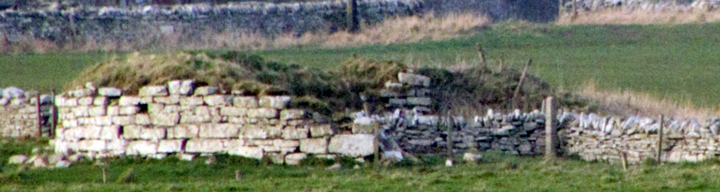
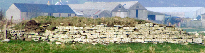
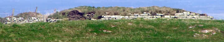
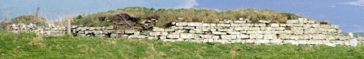
During the 1860s improvements the Burn of Nettleton had its course straightened. From a point on the 'upper' side of the broch a small conduit was thought to connect to a well inside the tower. This conduit passed through an oval enclosure east of the broch, though at the time Petrie only saw two walls some distance apart cut through where space had been cleared [by the broch builders or Trail isn't obvious in the text, presumably the latter] in front of the broch entrance. In the space and probably within said enclosure was a deep well, entered by several steps, covered by the time of the article. Between this vanished enclosure and the 12' thick broch wall, and a yard from the latter, Petrie saw a rough stone wall (probably concentric, gone now anyway) some 3' thick and ? 5' high. Petrie was informed that this was faced only on the inner side, and by analogy with other brochs it has been since suggested that this is upper wall debris. The conduit might stop at this point. At a point outside the south-western part of the main tower hard by this wall calcine bone fragments were found in two large fire-baked clay urns. Petrie describes their appearance as "rude" but they had carefully cut triangular flagstone covers, said covers being roughly at the same level as the broch floor. Cut into the rough wall to the north side of a line from the passage, and abutting the broch tower, he saw a three foot deep cell/compartment, which at the time of his visit was the only remaining one of several found by Trail, chiefly on this same side. The cell's entrance was only 22" wide and 2'6" high. None of these ??outbuildings were properly explored. There is dispute as to whether the broch walls survived to 6'6" or 8'6" high, but during the improvements about half of the stonework was robbed for the Glebe dykes [the field walls of the land belonging to the Manse] and by 1966 we are left with only a western arc upstanding. The broch entrance (now obliterated) is aligned approximately twenty degrees south of due east. For the first six feet its width was 2'9", at which point it reached stone door jambs and broadened out to 4' wide for the last six feet. The broch's interior has a diameter of 33'4" and Laing tells us that there was a second pavement some 18" above the first. Inside on a line with, and close to the left-hand side of, the doorway there stood a radial stone about 4'9" high and 4'6" wide, with a hole about 2 inches in diameter through it within 14" of the inner edge at roughly mid-height - close to the wall at the back of this stone a human skull was found. The plan show several arrangements of wall fragments and edgeset stones (now gone [or perhaps 'buried'] ) which Petrie thought post-dated the broch, though Hedges thinks that they could actually be contemporary with it. Within the broch tower wall three oval mural cells were roughly equidistant if you include the passage. Two chambers are describes as ruinous and the third to the south was deduced from remains. From the last nineteen steps of an intra-mural staircase ran clockwise from it, suggesting that the broch once had an upper floor. A subterranean passage near the centre of the interior led to five steps that gave access to a three foot square flag-lined rock-cut well near the interior wall - the bottom of the well lay 9' below floor level. It is now choked with debris but in Petrie's time it always held water.
On plan in looking at the outer cell remaining at the time of Petrie's notes it rather obviously cuts into the fragmentary concentric wall. So either it post-dates the broch collapse or that wall is at the very least contemporary with the cell. Could it be that the compartment is really one of the guard cells one would expect to find just inside the entrance. It survives too well to simply have been left outside the broch tower after some later re-modelling reduced the broch's diameter. So I think that the two walls are the inner and outer faces of a single wall, with the earth used as banking to shore it up. Which would give epic walls a minimum of 15' thick, similar to the East Broch of Burray which is (partly) surrounded by an earth rampart. A modern dig would be needed to give an answer to this as the two levels of interior floor surely means that the Trail/Petrie/Dryden material relates to two, perhaps more, building phases.