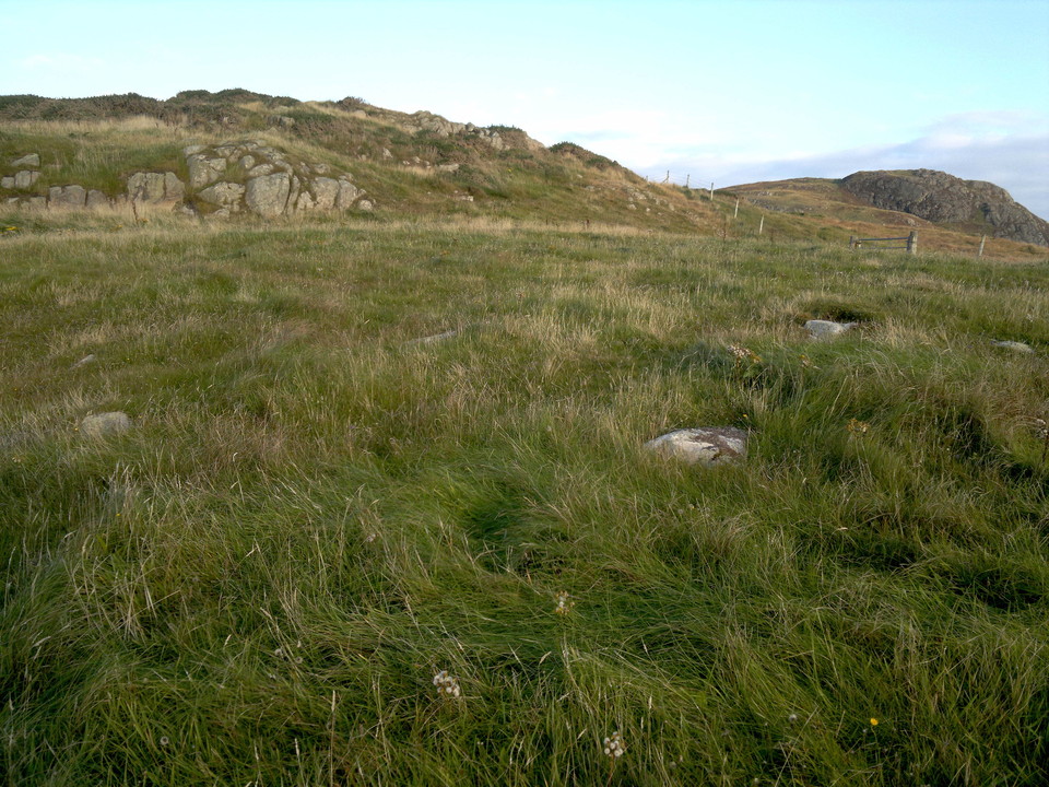
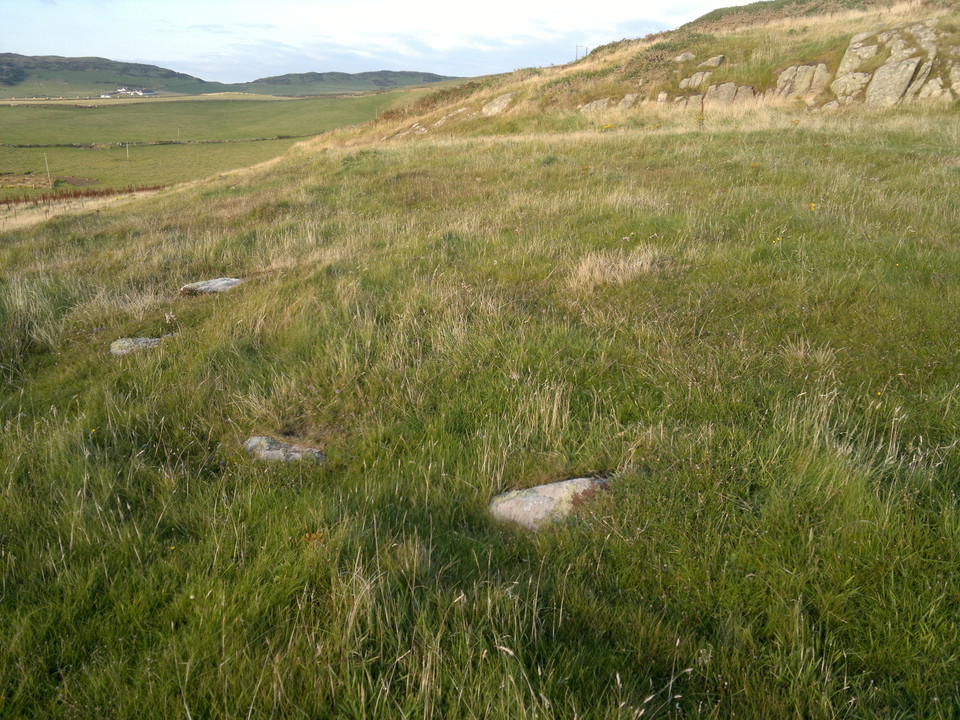
I had visited Crammag Head to explore and photograph the dun there, and had on my way found a long, crescent shaped turf covered Galloway dyke of obvious antiquity. This and the intriguing gorse covered outcrop nearby prompted me to do some fieldwalking subsequently. After first inspecting the adjacent abandoned coastguard lookout station I then noticed nearby a small exit through the dyke which on close inspection, looked an original feature. Passing through this I made my way up the sloping terrain towards the outcrop and then climbed it as best I could. Part of its summit and surrounds were covered by gorse of sufficient density to deter further exploration, and I therefore descended, but by a slightly different route. Walking southwestwards towards a field fence to get a photograph of nearby Dunman with its sensationally sited summit cliff fort I then found at my feet something that I had never encountered before.... poking through the turf by only an inch or two was an arc of four or five flat topped stones which were equally spaced to what seemed geometric precision. I then became aware that this arc was part of a circle as other stones were exposed in places, and little mounds indicated that more probably remained in situ just under the turf. I then realised that other exposed stones outside of this ring were part of another, surrounding circle, and that further exposed stones without the latter ring indicated yet another, larger surrounding circle. What I had found was tri-concentric. I stepped from stone to stone round the initial, inner ring that I had encountered, and found that by stamping my feet as I did so that indeed most if not all of its non-visible components remained in situ hidden under the turf. Maintaining an equal pace proved that all components were evenly spaced. A megalithic yard? My estimate is that this inner ring comprises fifteen or sixteen stones, giving an approximate circumference of the ring of 45'. The distance between this inner ring and the middle ring of stones and the latter and outer ring was approximately five feet in both cases. I did not do a test walk round the circumference of the outer rings, but I could see from such exposed stones as there were that, once again, they had been placed with geometric precision, but did not establish if there was a radial linkage with the inner ring. I photographed - in retrospect not nearly enough - trying to absorb this phenomenon. Initially I thought that it was the degraded remains of a cairn, but then discounted this as there was no evidence of spoil in the surrounding area, and also the inner ring, being on a slight dome, should have had most damage, whereas in fact it seemed the most visibly complete. One of my photographs suggests faint traces of shallow ditches between each ring, not noticed at the time. Photography using a drone overhead may reveal the true nature of this site much better than I was able to. The best definition I can think of for it is a tri-concentric stone setting - it doesn't fit the conventional notion of a stone circle, even though it is circular with stone components. None of the proscribed TMA definitions when adding sites to the database are really appropriate, so this site is a circle by default...the most accurate description from those available. This site is an enigma......sacred, ceremonial or astrological function I know not. It may even be unique. I hope that other more experienced and learned minds will be interested enough to want to discover which. In view of their proximity there may be comparable sites in Ireland or the Isle of Man... but from what reading I've done there's nothing comparable recorded on the latter. What I do know though, through subsequent discovery of online aerial images - see link below - is that there is a direct physical connection to the Galloway dyke and the enclosed land beyond in the form of a straight path or causeway of which some stones appear to be visible, leading from the gap in the dyke that I had come through straight towards the centre of the site. This path or causeway appears to have faint traces of a ditch at either side from dyke to circle and that these ditches appear to surround the outer ring of stones and meet each other thus enclosing the entire site. The presence of this causeway would, like the absence of spoil, point towards this site not having been a cairn. On close study of the aerial photograph linked below to these fieldnotes, which is accessed online by clicking on the red 'Photographer's Resource' wording - I advise making a paper copy 'in case' - it is possible to discern well over a dozen circular features of various sizes on the seaward side of the dyke, none of which being apparent as I made my way to my initial destination at Crammag Head. It is feasible that these features are hut circles, or remnants of the drip trenches thereof, and that therefore there may exist here in the hinterland of Crammag Head both the remains of a settlement and a contemporary physically interlinked circular feature of unknown function. I will leave it to others to find out and confirm. It could be that both are related to the earthwork westward, on the landward side of Crammag Head's stone fort or dun. Some authorities appear to believe that the dun is of later date than the earthwork. Of indeterminate date though, is the hill fort, the three ramparts of which I then found poking out of the gorse at the bottom of the NW side of the aforementioned nearby outcrop as I made my way in my already somewhat taken aback state back to my car at Slochmill, for which, like this site and the enclosure there are separate TMA fieldnotes - see the 'sites within 20km link' at the top of this site's webpage. I have checked at length online and there appear to be no records for either circle, settlement nor fort. Quite a day: I would always advocate fieldwalking the vicinity when visiting known sites as you never know what you might find, and remember to look down as well as around - there is a lot more out there.......... NB: As this site is so hard to see till you're on top of it, apart from walking up the causeway feature perhaps the best alternative way to find it is to follow the wire fence that runs from the coastguard lookout near Crammag Head light uphill towards the rocky outcrop. As you approach the latter you will see a metal gate in the fence. When reaching this, head away at right angles a few yards, and you should start to see the stones at your feet. Make what you will of this place.. archaeological investigation is surely metited. Site visited - or discovered? - 3rd October 2015.
Clicking on the red wording above will reveal an invaluable image showing the three Slochmill sites. Paper copy adviseable for those interested. To locate the stone circle - or setting - first look a the structure to the right (south) of the lighthouse. This is a WW2 Coastguard lookout. The dark line heading up the image from adjacent to the lookout is a wire fence. It intersects with an inverted crescent shaped feature which crosses from one side of the photograph to another. This is a Galloway dyke. Moving from the intersection with the fence leftward around the dyke's circumference a gap is visible with a straight, possibly stone topped path or causeway leading outward and upward from the dyke. It leads directly to the stone circle, some component stones of which are visible as grey-white dots. The path to the circle looks to have degraded ditches either side not seen when fieldwalking, denoted by darker vegetation, and there seems to be the faint trace of a ditch surrounding the circle, once again not noticed when fieldwalking. Inward, or seaward, of the dyke there are a number of circular crop marks, if the image is studied closely. Most are close to the dyke, predominantly towards the centre of its curvature. That they may be hut circles would only be confirmed by excavation. As before, they were not apparent when walking to Crammag Head dun. If proven though, they could be contemporary with the stone circle. The three ramparts of the fort commence due left ie. North, of the circle and encircle the base of the gorsey outcrop. Construction of this may have been incomplete as there are terraces between each rampart, not ditches, and I found ramps between each terrace. A three terrace fort from the Iron Age exists at nearby Kirkmaiden - the Canmore name of that site is Core Hill - for which there are separate fieldnotes on TMA. The similar construction of Slochmill's fort may indicate it is of contemporary date. My gut feeling is that at least some of the hut circles, if that is what they are, are of earlier date, perhaps mid Bronze Age.