|
|

|
|
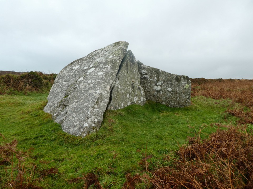
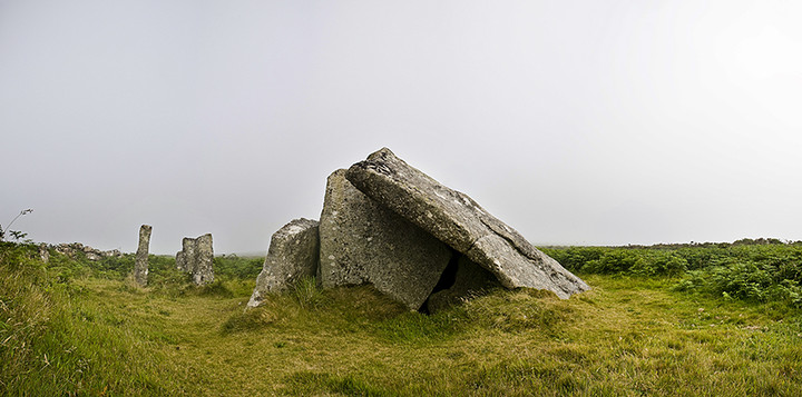
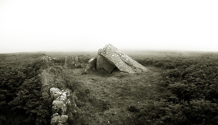
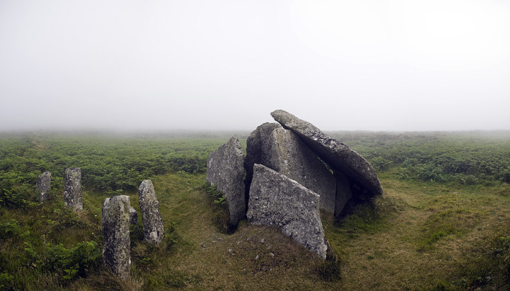
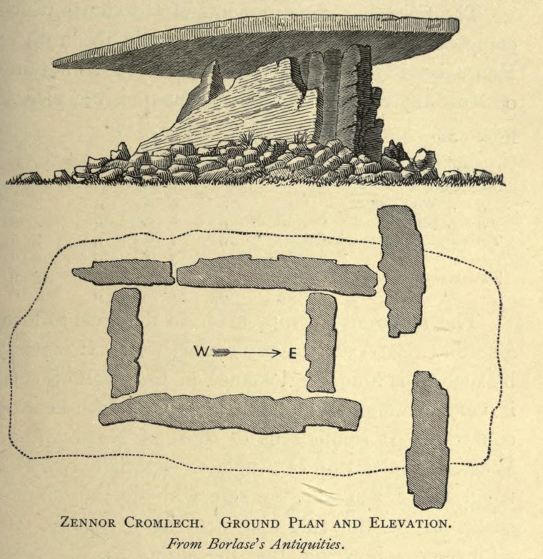
Zennor QuoitDolmen / Quoit / Cromlech
|
|
|
|
Images (click to view fullsize) |
|
Photographs: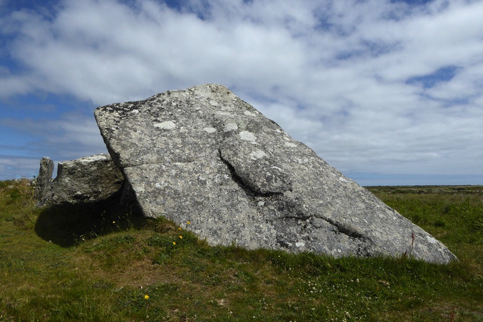


 Artistic / Interpretive:
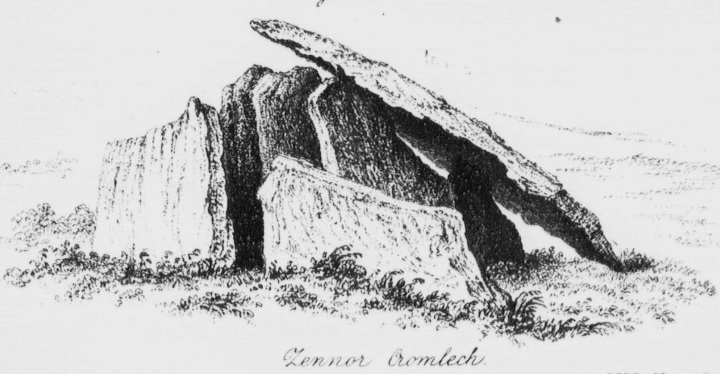
|
Fieldnotes |
|
|
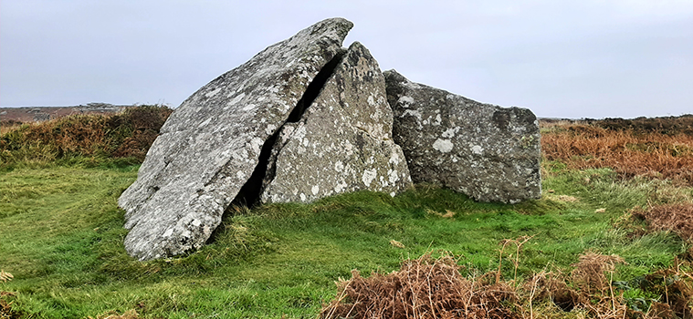
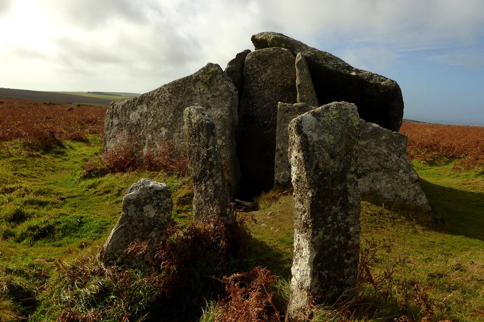
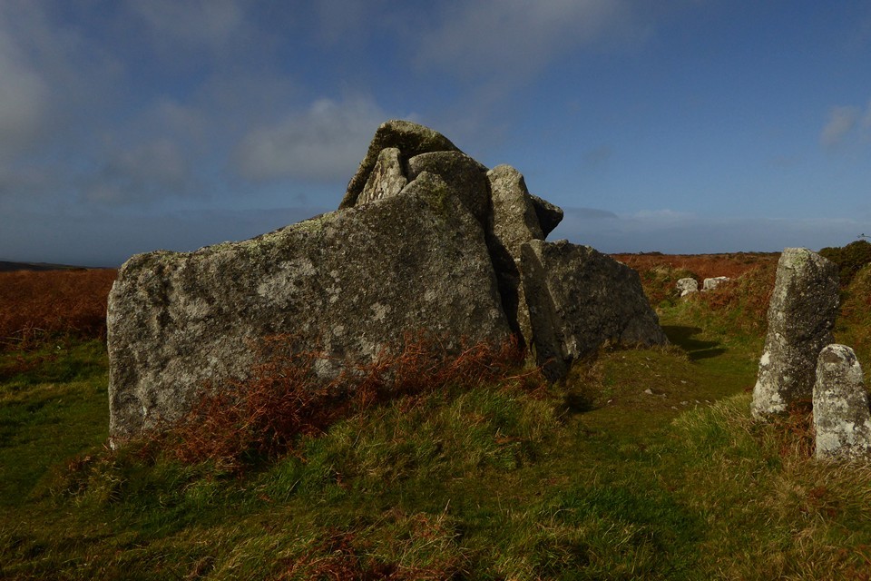
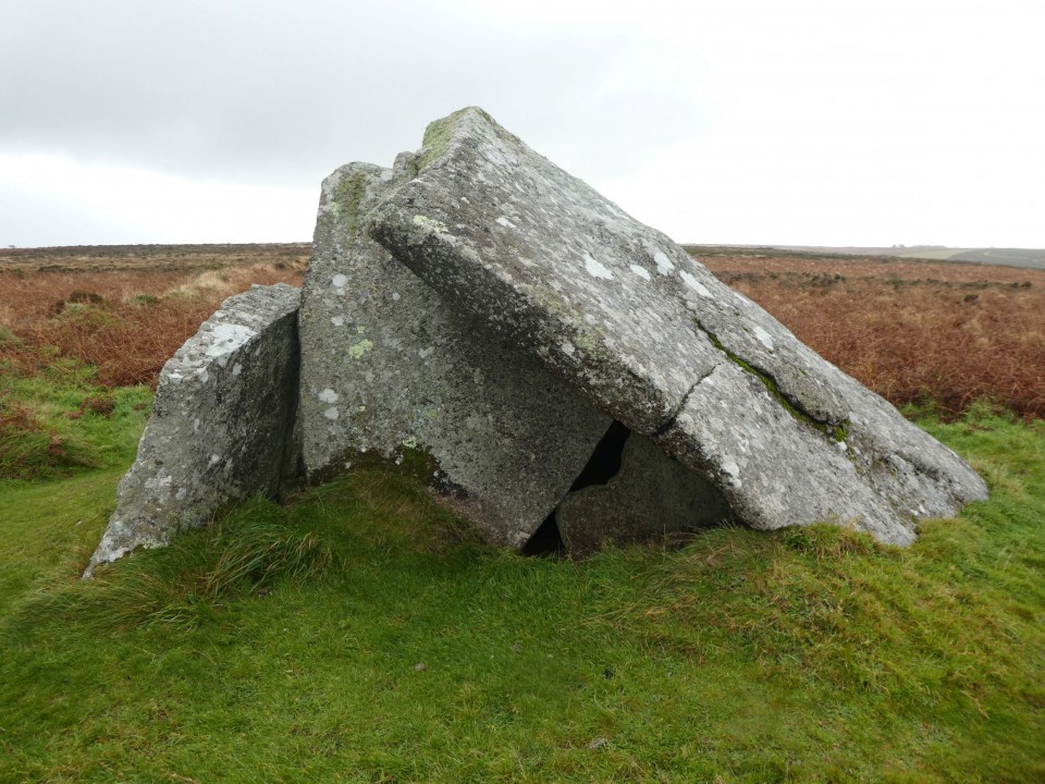
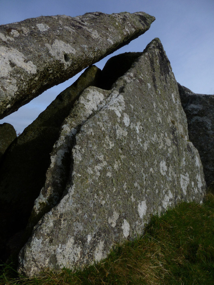
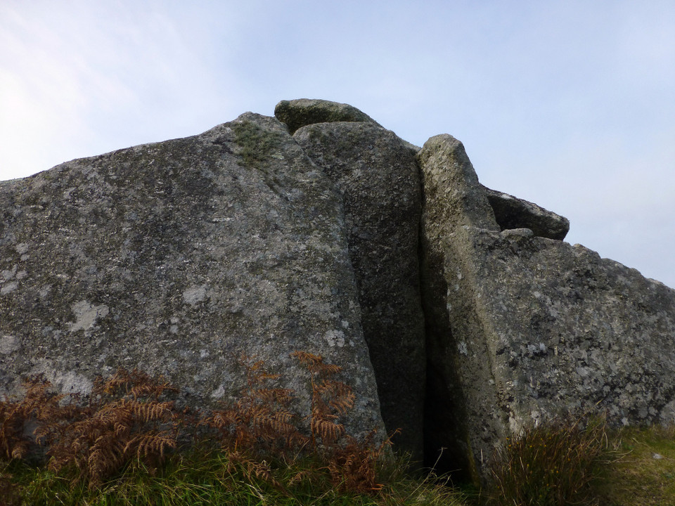
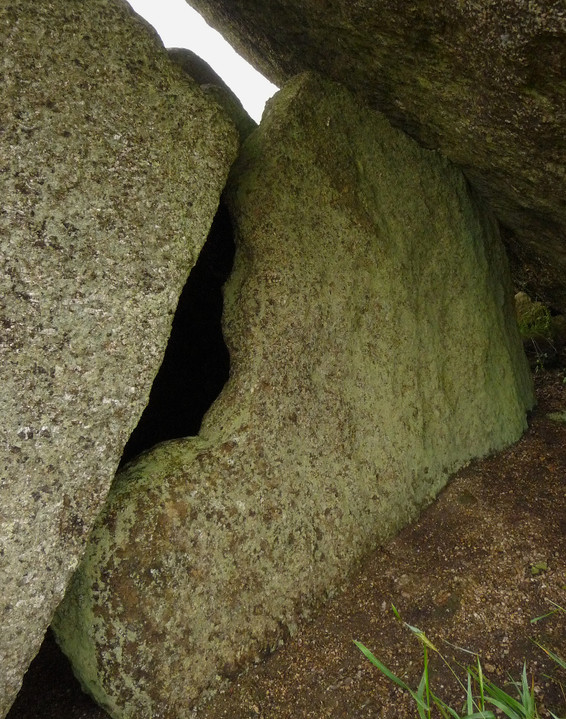
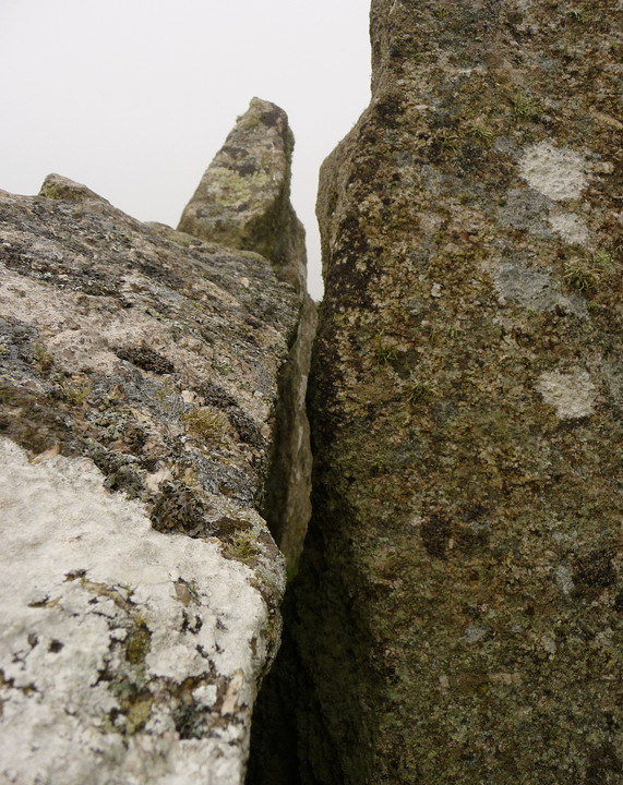
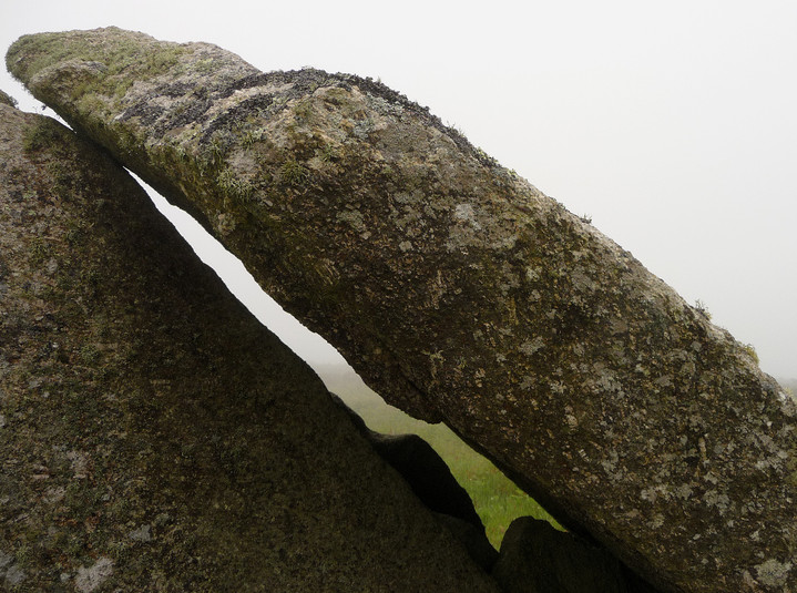
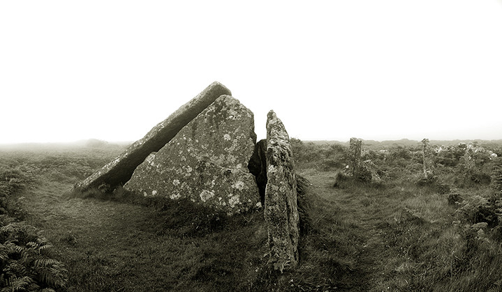
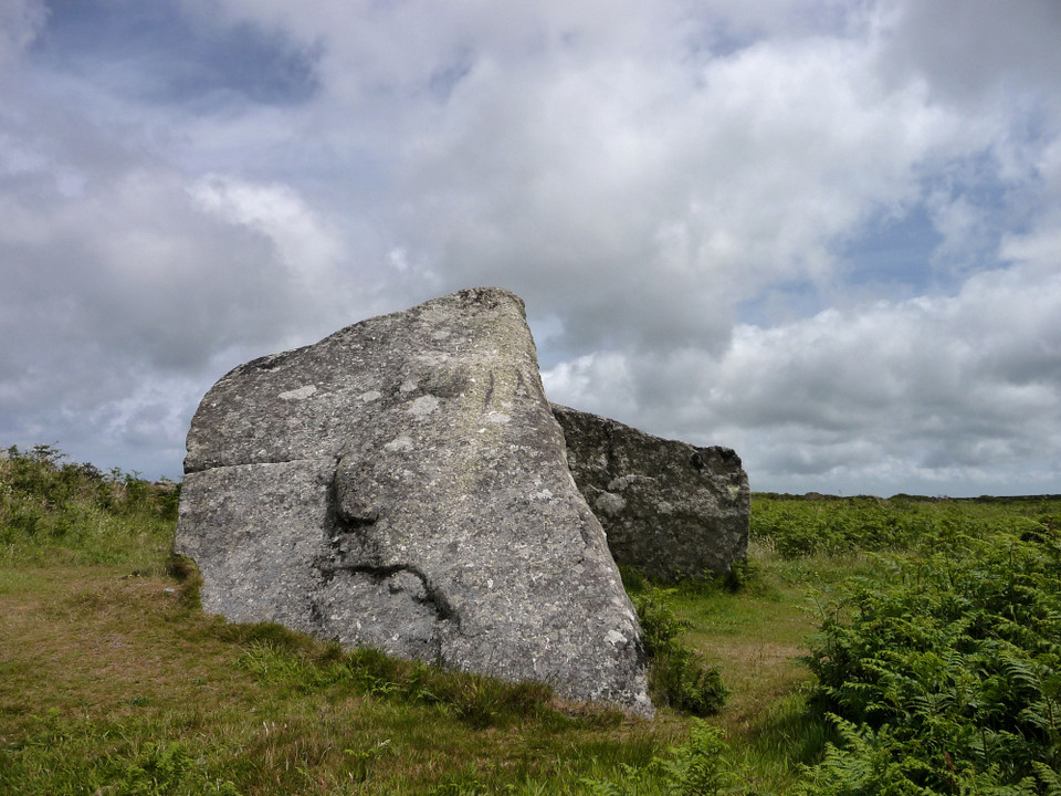
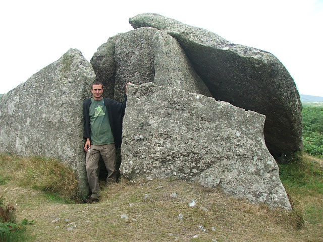
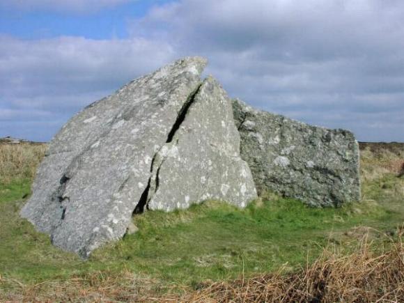
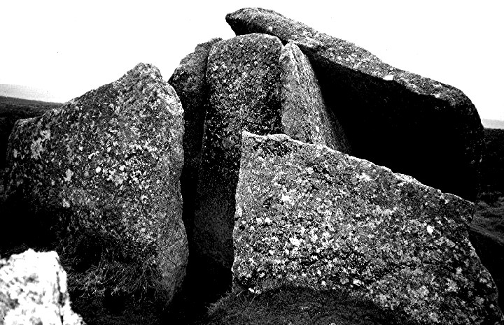
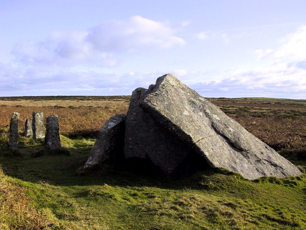
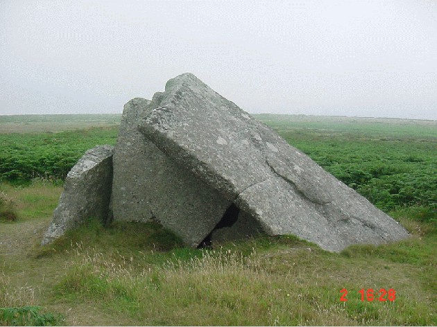
Site visit: 20th September 2012. I made this flying visit back to Zennor for two reasons. Firstly, I wanted to see it and the surrounding landscape without a blanket of fog surrounding it, and secondly, I had read of the Borlase account of the farmer being paid 5 shillings to stop breaking up the stones to use as a cow shed or field shelter, so thought I would check this out. I wasn't to be disappointed on both accounts. On a clear day this time the landscape was, as one would expect in a moorland setting, remote, haunting but with a feeling of peace in the air. After yet another look around the quoit but this time taking full measurements, orientations etc I had a very close look at the right-hand side front facade stone. Narrower in width to its partner on the left it is also, today, short in height compared to it. The reason, because this is one of the stones to be desecrated by the said farmer. As the photos show, a close look at the top of this stone shows the drill holes made either side of this facade stone where the steel wedges were inserted to split the stone and coincidentally, in the background, the very stones that were split off as if cocking a snoop at us set amongst others! As the holes are randomly drilled it will be an easy task to seek out the two? sections of stone removed off the top of the facade stone by measuring the gaps between the semi-circular drill holes on both the facade stone and the ones used as uprights to the shelter. This I will do on my next visit after I have made a 'sliding template' to make life easier for myself. https://picasaweb.google.com/100525707086862773355/ZENNOR?authkey=Gv1sRgCNWevuuX_rjRHg#5792007563200663426 |
Posted by Sanctuary 25th September 2012ce |
|
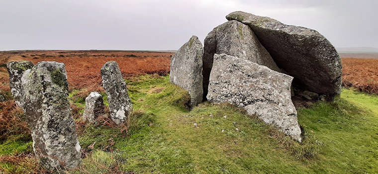
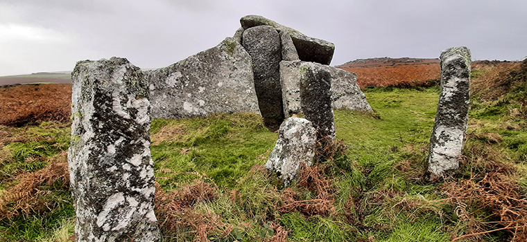
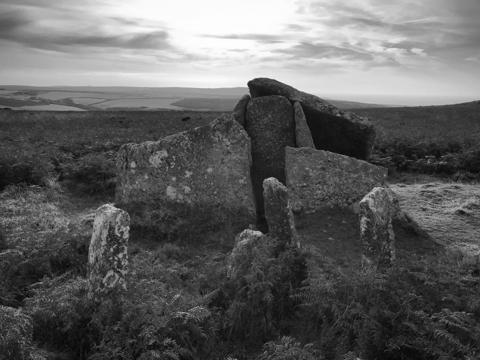
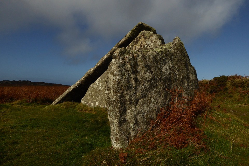
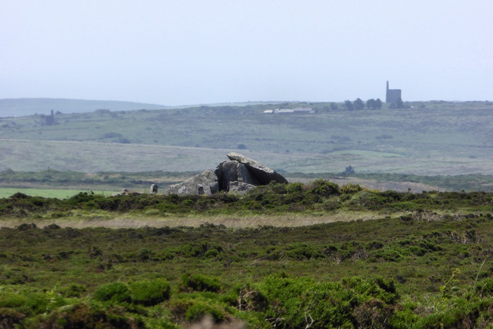
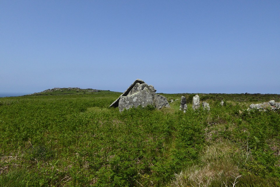
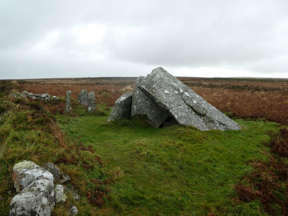
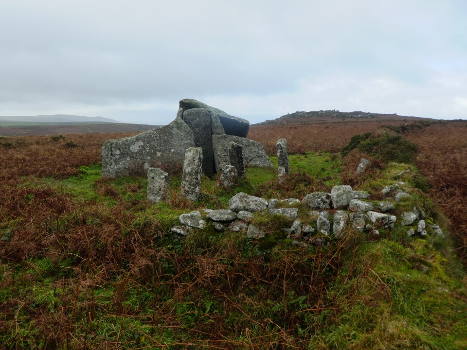
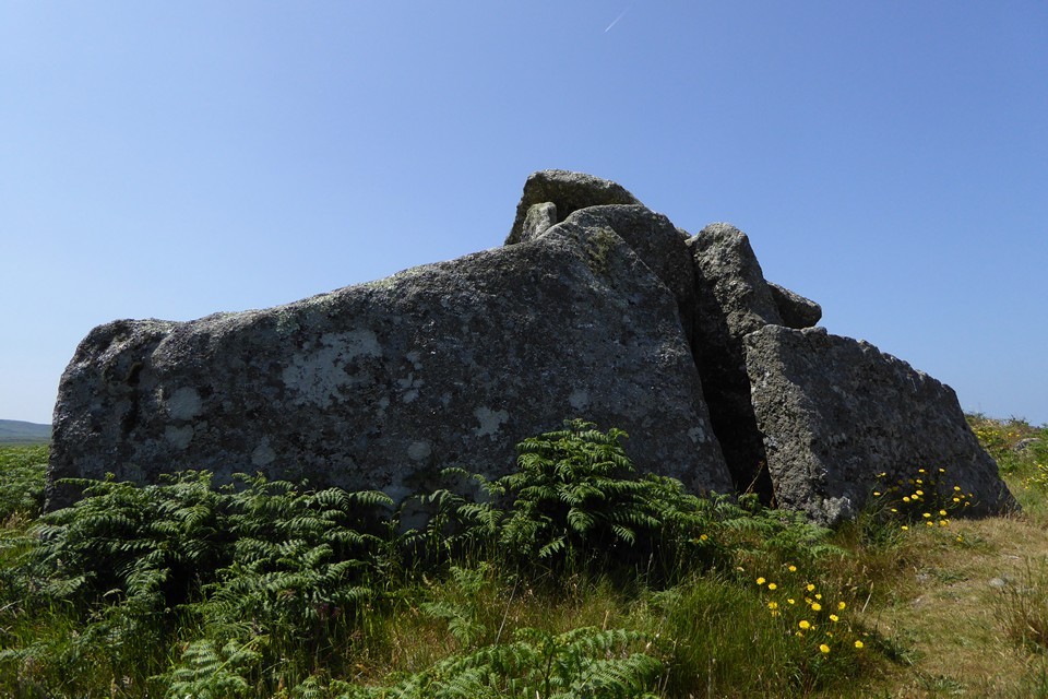
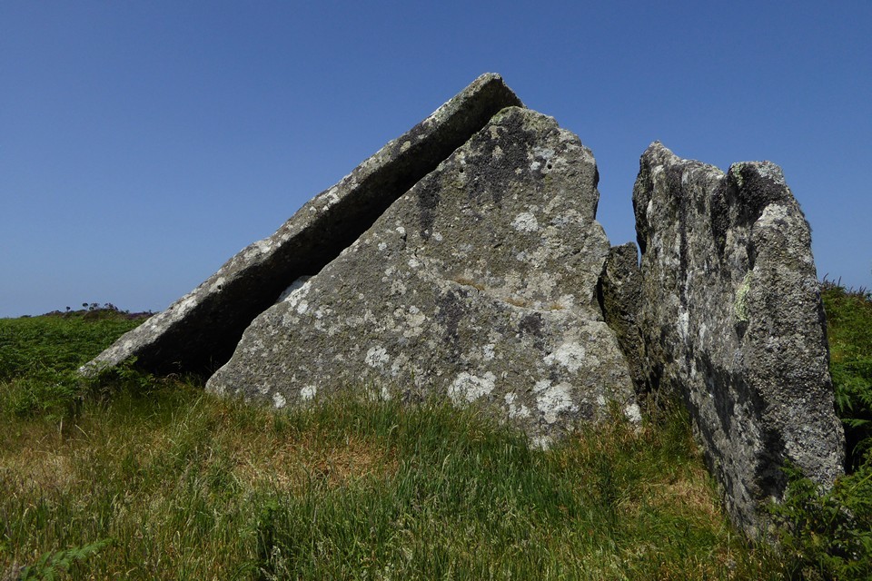
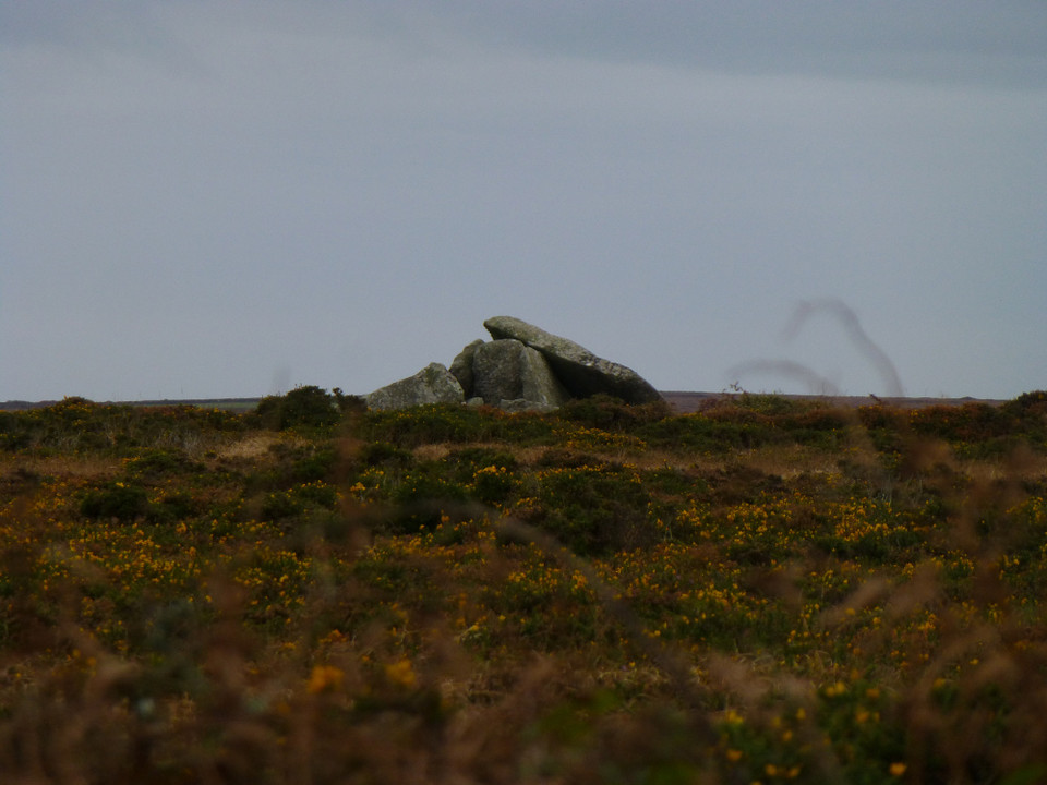
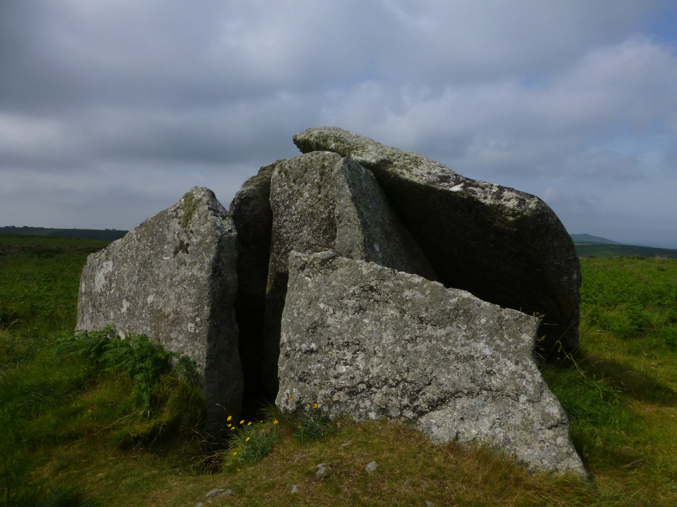
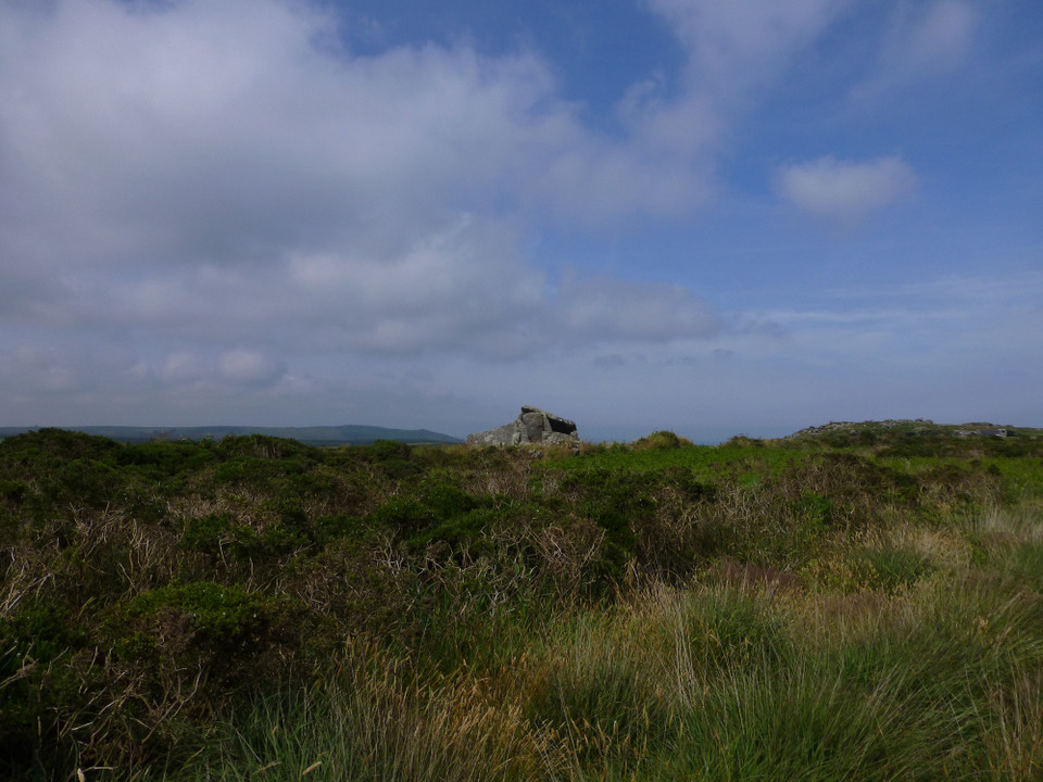
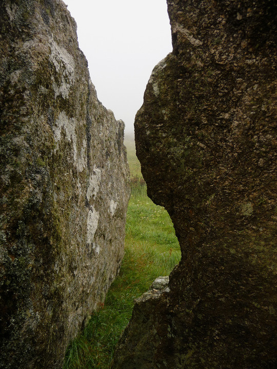
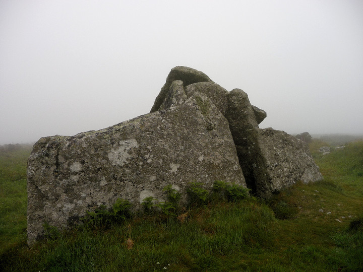
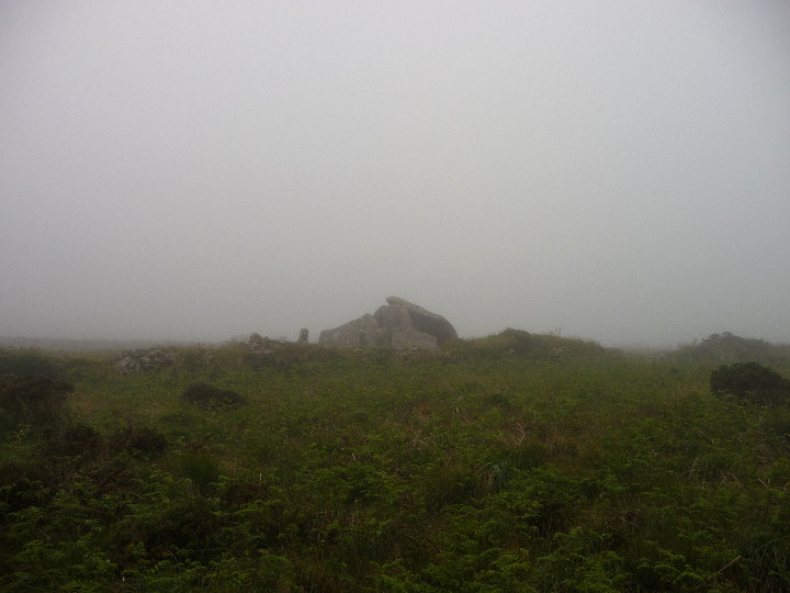
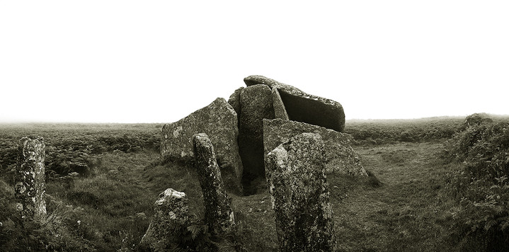
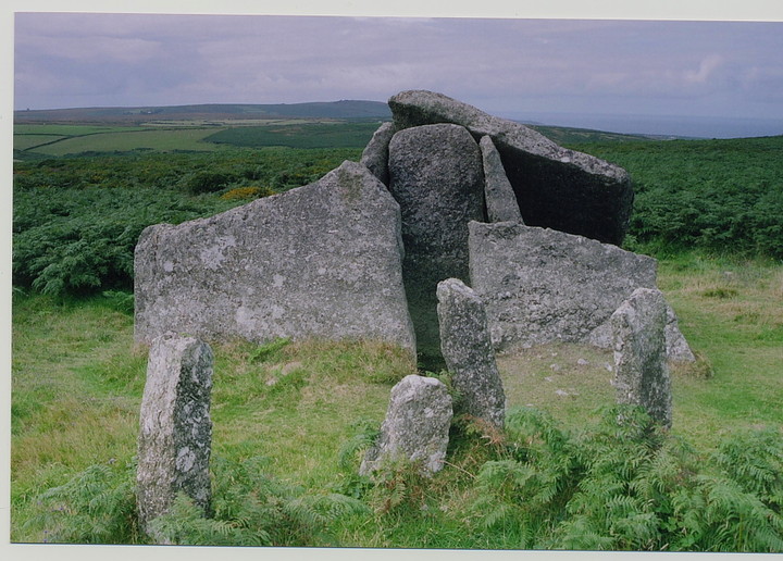
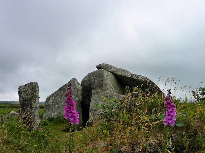
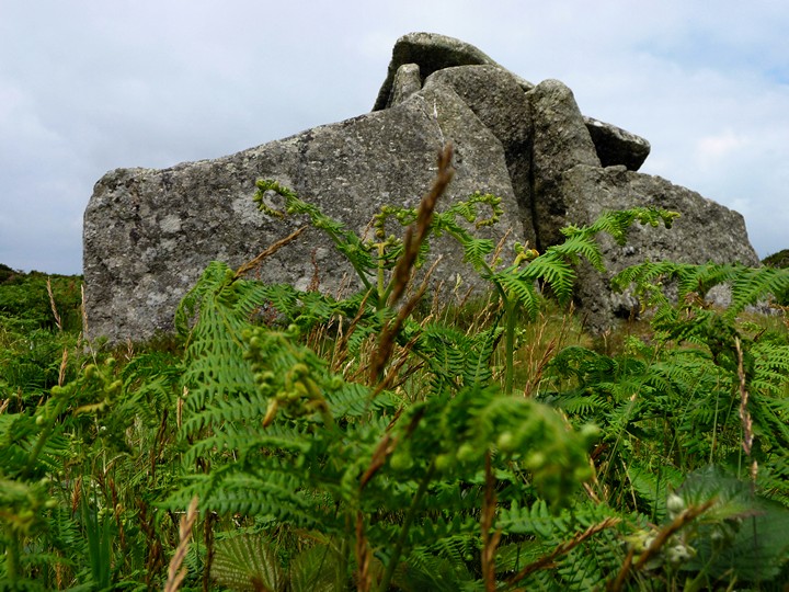
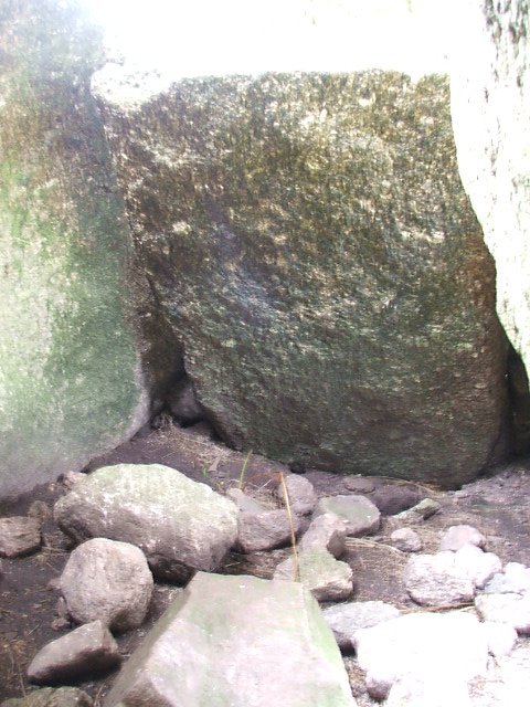
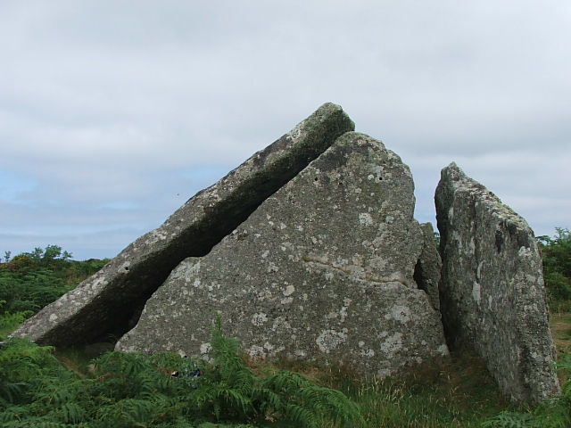
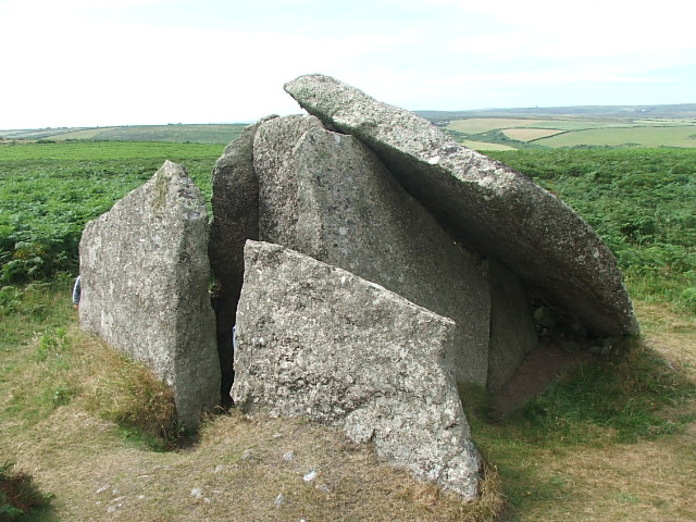
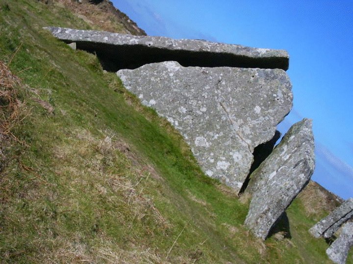
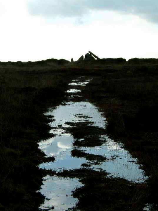
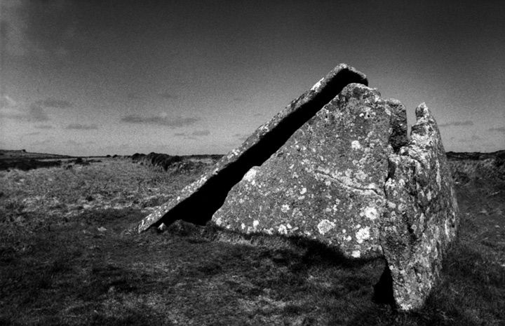
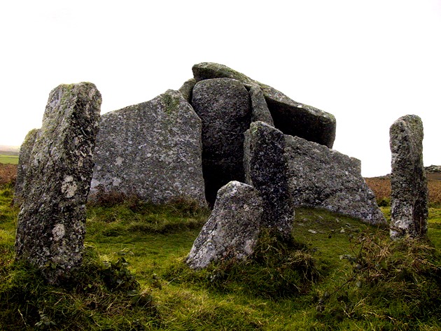
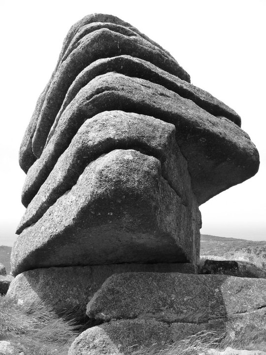
Zennor Quoit Site visit 4th September 2012 Well I couldn’t have chosen a better day if my intention was to not find this iconic Penwith site as it was completely fog/mist bound! I had approached the area via the B3306 road from the east (St Ives end) heading for the Eagle’s Nest house which thesweetcheat had mentioned was in the area marked as Higher Tregarthen on the OS 1:25 map (102). It was so foggy that I drove past the house three times looking for its name and never did see it, even when I walked by after parking up. So, coming from the east, I parked in a small parking place on the left about a hundred yards prior to the house which is on the right on the very brow of the hill. As you climb the hill you will notice an outcrop of rock not unlike a small tor on the left very close to the parking spot https://picasaweb.google.com/100525707086862773355/ZennorLandmarks?authkey=Gv1sRgCPar6of71Z_COQ#5785902295554289986 Walking from there with my two dogs Chief and Indy, I stood near a building to the right-hand side of the house https://picasaweb.google.com/100525707086862773355/ZennorLandmarks2?authkey=Gv1sRgCKz4vK2l1-3D3QE#5785903498007072818 and looked directly across the road. It was so foggy I could barely see across to the other side, although when I took the photos on my return it was much clearer! Across the road was a collection of boulders that had been placed across a ‘path’ that went off into the distance. https://picasaweb.google.com/100525707086862773355/Zennor3?authkey=Gv1sRgCL2fy5_i9LLVKg#5785905121013105186 It wasn’t even a track as such as it was so overgrown but I felt I ought to try it as I could see nothing else remotely like a track due to the fog. As we ventured into the mist the thought went through my head that I must be nuts to even consider venturing out into unknown territory in such conditions…but we did! After about two hundred yards the track came to an ‘entrance’ flanked by two stone posts which I passed through. So far so good. https://picasaweb.google.com/100525707086862773355/Zennor4?authkey=Gv1sRgCJSx8-y3xdPRyQE#5785906039772289314 On and on we went and it was noticeable that this tiny track only some 18” wide at best was bearing around to the right in a large curve. Other than that I could see zilch. The gorse is impenetrable so you just have to stick to the path and make sure you are wearing tough old jeans or leathers. After about 20 minutes of pretty slow going we arrived at a derelict building called the Carne I believe. TSC suggested turning left south-east here and I took that to mean you walked alongside the building before turning, but I was wrong as it is just a dead end after the building. At this point I thought it too risky to carry on because only metres from the building it was lost in the fog and I felt a complete idiot for even attempting it. So I decided to turn back but had only retreated about 40 yards back down the track when I saw Chief disappear off to the right. Aha I thought, is this the ‘left’ path? So, following close behind the dogs I ventured on and after another 2/3 hundred yards the track widened right out to something like 20ft wide with the tiny worn path still running down the middle of it. That cheered me up because I knew we were now on the right track but why it took so long to widen out was a bit of a mystery to me! After about another two hundred yards the dogs suddenly shot off to the right again up another track. I saw them start but they soon disappeared into the fog so I decided to follow. Lucky I did, because within a few seconds Zennor Quoit loomed up out of the fog. Phew, we’d made it but what a journey. It wasn’t the distance so much but the tension of not really knowing where I was that slowed everything down and put me on edge. But, we were here and it was magical and if as by magic, the fog suddenly began to lift and actually added to the experienced and I quickly got on taking pix and shooting a vid. https://picasaweb.google.com/100525707086862773355/Zennor5?authkey=Gv1sRgCKeUkKCcztKgFA#5785907009353388146 All sorts of questions were going through my mind about this quoit as I filmed and my first impression was that the capstone had only slid to the rear and to the right-hand side and not off a tall back-stone as shown in Borlase’s sketch of 1769. I wondered why they had gone to the effort of shaping huge side flanking stones if the slope on them was not to be accommodated by the capstone as it is now as such. Looking inside the chamber where bones or cremations would have been placed, there is a stone leaning the full width of the chamber that if raised fully would fit exactly where a back-stone should be as it would be level with the top of the sloping section at that point. But, if the lid was really up high then we have to accept that unless Borlase drew what he assumed it would have been like originally, then that’s how it really was…at that time at least! It does puzzle me somewhat though that he shows the now missing rear support as being almost needle-sharp and very slender for a stone that is supporting such a vast and heavy capstone that other than that only rested on the front closure at the opposite end. https://picasaweb.google.com/100525707086862773355/ZennorQuoit#5784957939740525794 Another puzzle is why he assumed it was completely covered at one stage seeing that there would have been such huge gaps that would allow the ingress of cairn material into the burial chamber. If it was to be covered then it would have been boxed in full height surely and not have sloping sides. Its complete covering had to be pure speculation on his part, possibly spurred on by the material he shows to the lower regions which to my mind (more speculation) would only be there to add rigidity to the base. That apart, it is a wonderful sight to behold. Heaven alone knows how long it took them to shape those angled side flankers and prepare the front closure and raise the lid. The façade stones are just as big and you can only admire the tenacity of the builders for undertaking such a task without the benefit of the machinery at our disposal today. I assume the main orthostat is earth-fast otherwise it would have been down now for sure. It was disappointing that the fog prevented me from observing the landscape surrounding the quoit but that’s how it is sometimes on the Cornish sites so close to the sea, but I will return. Getting there for me was a challenge when the fog blanked it all out but it tested and confirmed my great will to still defy the conditions in the quest to appreciate what our great ancestors left behind for us. I hope it never leaves me for what is life when your sense of adventure and thirst for knowledge is no more! Photos: https://picasaweb.google.com/100525707086862773355/ZennorQuoitPhotos?authkey=Gv1sRgCL2kwqWT76aaOg# Roy |
Posted by Sanctuary 8th September 2012ce Edited 8th September 2012ce |
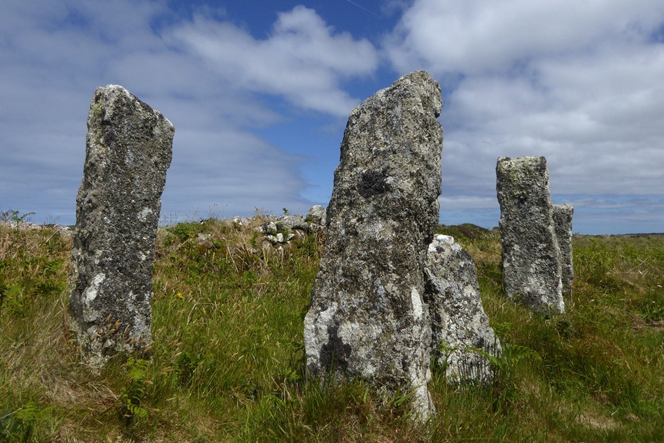
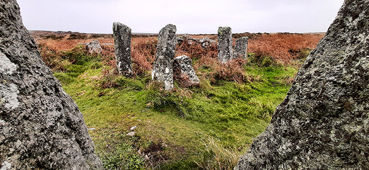
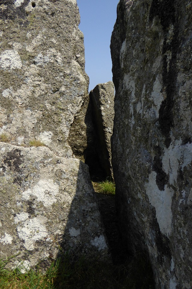
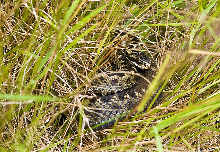
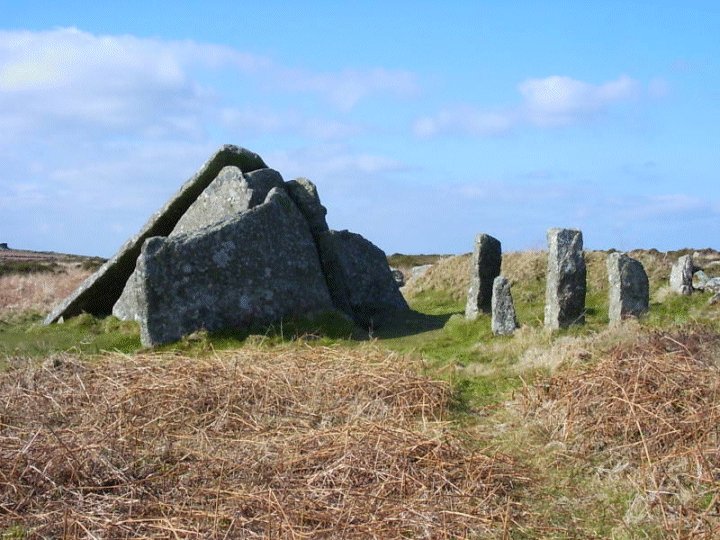
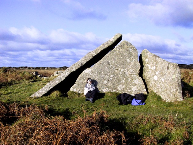
| I have to concur with Carl on this one, it really was a trial to find. This was however confounded by a really thick mist that had been hanging around the peninsular for two days (in late July!) and I think if I hadn't had an OS map I might never have found it. Starting from the car park at Zennor I crossed the main road near the telephone box and took the footpath that runs along the bottom of the hill and I remember wondering at the time whether there were any snakes around? We'd already seen a number of very small lizards on the cliff path to Gurnards Head when just in time I stopped myself from stepping on an Adder at the side of the path! Usually when I've encountered them in the past they slither off as soon as they know they've been spotted, but this one stood its ground and even allowed me to get relatively close to take its portrait! Having jumped over it I carried on along the path when, blow me, I encountered another which, thankfully, disappeared into the undergrowth. Passing the farm buildings I then started to make my way up the hill towards the Logan Stone but having reached the top, encountering yet another adder, I found myself completely disorientated because I couldn't work out where the sun was due to the mist and wandered around for about half an hour becoming increasingly panicky. Then, just as I was about to despair and make my way back down, there was a very brief break in the mist across the moorland and I could just about discern what must surely be Zennor Quoit about 300m away. Rechecking the map as the mist rolled relentlessly back in I made a mad dash to get there and felt a huge relief as it came into view just the other side of a low stone wall through the ferns and gorse. My first reaction on coming up close to it was its sheer size, it had looked quite insubstantial from a distance, but this really is a whopper and quite beautifully constructed. I didn't realise the significance of the 5 pillars alongside it at the time so I was quite intrigued by them and also the tiny holes which appear all over the structure. I think the combination of it being hidden in the swirling mist and having had to really struggle to find it gave it a special kind of significance for me and it presented itself as a reward if you see what I mean. Well worth visiting but I would advise anyone attempting to find it in adverse weather conditions to have a map and a compass...... oh, and look out for snakes. |
 Posted by A R Cane
13th August 2011ce Edited 2nd January 2012ce |
|
Visited 11.4.10. What a walk to get to this place!!! Probably the worst 'path' I have ever had to follow to get to a site. Firstly, very difficult to park on the B3306 where the 'path' starts from - opposite a house. I eventually found a grass verge to pull over on about 100 metres down from the house. First the good news, the start of the path is easily seen. However, from there on things get worse! Follow the 'path' up the hill - heading towards the derelict farm buildings on the brow of the hill. The 'path' gets narrower and narrower and the bloody gorse gets higher and higher. As you near the farm buildings the path takes a sharp left and the 'path' is now about 8 inches wide, with gorse at chest height. No other option but to take a deep breath, hold your arms up out of the way and battle through it!! Painful. Things then improve a bit and you finally reach the quoit, the other side of a crumbling stone field wall. The site itself is clear and despite what I have said, well worth the effort and pain to visit if you are physically able to do so. There are 3 fairly large standing stones next to the quoit and the slant of the capstone is definitely worth seeing! I couldn't squeeze through the very small gap to get inside the quoit. It took me 25 minutes to walk from the road to the quoit. |
Posted by CARL 20th April 2010ce |
|
This was to be our last site before heading home, but will be remembered most. This must be the biggest capstone round here. Just how did they get it up? Crazy. We parked on the B3306 and followed the path south (not easy going at all). It went this way, then that way, and I wondered if we were on the right one, but it got us there in there end. After the long hard walk I was surprised to find other people there. They sat on one side and we had the other. After a while we went over to the rocks by Sperris Quoit (didn't go to it though 'cause it's unrecognisable as a quoit). The rock's were really stone island's in a sea of bracken and thorny gorse. Not wanting to retrace our steps, I decided to cut through it straight to the car. Big mistake! With a 7yr old on my shoulders and a 4 year old in my arms, it felt like an army yomp and I came last. Damn gorse cut me to shreds but I did see a smooth lizard for the first time ever. Karma's a funny thing isn't it. PS. Why dont they get rid of the cow shed stones? |
 Posted by postman
4th August 2006ce Edited 14th August 2006ce |
| I love this place! Came here with the wind blowing and heavy rain soaking me through. I sheltered in the old mine buildings on my way up from the 'Eagles Nest'... with night falling I sat with my back against the huge upright and sank into nothingness. Inside was where the ancients were laid to rest and in my thoughts I allowed myself to fall through that big piece of granite and sit with the old ones... with them I spoke and with them I knew all would be well... |
12th February 2005ce Edited 14th August 2006ce |
|
How has the quoit changed in appearance since it was built? Are Borlase's sketch and Craig Weatherhill's drawing in Cornovia anything like the original? Why would people with not a lot of free time on their hands find or fashion tapered stones and then balance a 10 ton capstone on what in comparison is a needle? Why take on a huge amount of work to get an inferior end product? Where is the back support, the stone in-situ is to short to put the capstone any where near level. What filled the gaps between a level capstone and the tapered side stones? Besides the capstone sinking into the ground somewhat and maybe shifting to the north I feel the the quoit is as the builders wanted it. |
Posted by Clive Williams 27th June 2004ce |
|
With the weather forecasters telling us that the whole country was to be in the grip of an Ice Age by mid week I headed for subtropical St Ives. My partner had a two day conference to go to so I thought I would join her and get in some walking at the same time. Tuesday 27th Jan 2004 Drove out of St Ives a couple of miles to the hamlet of Towednack. In the porch of the church on the right is a recumbent stone that according to Ian Cooke's guide to the Tinners Way came from Crete in 2000-1500BC.{{1,2,22}} Left the church and took the footpath heading west to Beagletodn. Just after the house a gate on the right (padlocked) has to be climbed over so a track can be followed. You will find in these two walks that I have not stuck to legal paths but made my own way over what is essentilly wild moorland. This is possible in mid January as the bracken has died down but even so I would reccomend wearing waterproof trousers and taking a stick. The track twists its way amongst boulders and water features untill you come to a gate near the Pump House featured on the OS map. Go through the gate and turn right. You will soon find yourself walking up between two walls (not for the last time that you will be following ancient trackways). At the top of this track you come to another gate, once the other side of it it is time to head out over the moors towards Sperris Quoit. {{3,4,5}}Known as one of the most elusive sites in Cornwall I battled my way through the bracken and gorse in a north westerly direction untill I saw the pile of rocks on the skyline. Don't be mistaken by Sperris Croft, a smaller pile but nethertheless named on the OS map. Reaching the rock piles you will get great views over to the coast and also of Zennor Hill. The quoit lays just to the south of the rocks and can be distinguished by one triangular upright. Even from here it is not easy to reach and requires some scrambling amongst the stones. Keep an eye out for the ancient stone wall that runs off to the SEast, did they use stones from the quoit in its construction? Leaving the rocks walk towards the ruined mine building. Wheal Sperris was a small mine started in the early 1800's, all around this area are open shafts, water channels and various holes in the ground. If you do leave the path, beware, it's pretty uneven ground. Zennor Quoit looms on the horizon to the SWest and the path is easy to follow. {{6,7}}Once there I was undecided as to which way to go next, down to Zennor and the Tinners Arms, or onto other sites. The fact that I could see Mulfra Quoit on the horizon weighted my decision and I decided to head south along the old trackway before turning west to the Bishop's Head and Foot boundry marker. This involved trudging through along muddy paths but the sense of space and the fact that the sun was shining made up for it. On the left hand side of the road beside Kerrowe Cottage is a stone with a nice carving on it, I don't believe it tobe very old and judging by the "standing stones" opposit possibly a residents artwork. Follow the tarmaced track to the road then carry on ahead to the "main" road. Cross the road and find the path that leads up over the northern saddle of Mulfra Hill. Yet again I decided to head out cross open moor and took myself off up the side of the hill. A couple of times I thought I had stuimbled across an unknown stone circle lying hidden in the gorse but decided my imagination was playing tricks. There is so much rock up there and at times you can trace a large arc between them, but never mind. Eventually I picked up a path and found the quoit.{{10,9}} I could not have asked for a better view, the Lizard stood out clear as a bell, St Michael's Mount sat below me and the sun caught the roofs of Newlyn giving them a silver coating. Time for a cup of coffee and a rest. I suddenly realised time was getting on and I was far from the car. A footpath supposedly runs east from here down to the road but somewhere along the way I lost it and just plunged down the hillside dwarfed by boulders before reaching a forest of Rhododendrons. I had thought of visiting the Tyre Menhir but time was getting on so I headed to Tyre Farm and turned left along another muddy footpath. Reaching a large Badger holt the path carries on cross a field to a gate beside a small pond (puddle!). In the next field a new fence has been eracted and the route of the path is not clear. However what is marked on the OS map as a round wall around a shaft interested me, is it just a round wall or is it a hillfort?{{11}} I climbed over the new fence at the far end of the field having decided there was no way through the hedge and skirted the pond before finding a rusty gate hidden in the undergrowth. It was impossible to open so I climbed over, disturbing a fox in the process. Turn left along the valley and you soon come back out onto the Kerrowe track, turn right. THe simple way back from here is to follow the bridleway around the south side of Amalveor Downs to Embla Vean then by road to Towednack. I chose a slightly longer route heading more to the south but this did not include any sites of TMA interest except for a couple of tumuli sat overgrown in fields. The walk took me about 5 hours including stops and it's not just a trudge between quoits it's a walk that offers lots more, space, views, and if like me you don't meet anyone all day, solitude. 28th January 2004 Started day 2 at the carpark beside the engine houses of Carn Galver mine (on the B3306). It was here that my love affair with Penwith began. On a blustery day in Feb 1987 a friend gave me my introduction to rock climbing, if you want to get close to this landscape try hanging on to it by your fingers whilst the waves crash 200ft below you. Today I head away from the sea, up the footpath/stream that runs along the west side of Carn Galver.{{12,13}} I have been up amongst the rocks before so today I carry on to the crest of the hill untill I come to a crossroads of paths. Turning right brings me to the field in which the Maen Scryfa stands.{{14}} Sadly the sun is right behind the stone so reading the inscription is not easy and photgraphing it impossible. I am struck by the contrast between lush green fields, stone walls and barren moorland. The dead bracken has turned much of the landscape a dull brown colour, only turning gold when the sun hits it at the right angle. From the maen Scryffa it is a short walk to the men-an-tol, all is good there and after a short rest I carry on in the direction of Greenburrow Engine House (commonly known as Ding Dong). Just after passing the little stream I noticed a pile of boulders on the right hand side. Amongst these and just beside the path is a square pit. Gorse and hawthorn grow out of it and it is full of water. I plunged my stick it and found it had a bottom, not far down. Like the "Hillfort" yesterday could this be an undiscovered cairn? or is it a mining relic, I will do some research and see what i can find out. Ding Dong reached and explored (I wont bore you with mining details) I headed back towards Boskedndan circle.{{15,16}} The footpath is thin and runs through gorse and bracken but by following the wall I found my way to a cairn on the south end of the ridge. This lays buried amongst gorse, but with most of the other bracken etc dead it was possible to make out the stones that form the cairn. The ridge runs north towards Carn Galvers mighty south peak and the stone circle is soon reached. It is rather a wet area in winter and a couple of times I was glad of my stick and high sides of my boots. I missed the standing stone but did explore the tumuli at the north end of the ridge before charging out across the moor to Little Galver, the rocky luump to the east. This was hard going! I wouldn't reccomend it but I had decided I wanted to visit the quoit at Bosporthennis. After a lot of hard work I reahed the walls that surround the quoit. Wow! this is a stoney landscape but imagine how many stones were used to build these walls? Up to 4ft thick inplaces and about 5ft tall we marvel at what it took to build the monuments but think how much work went into building these. And how old are they? who knows, some say the field patterns down here date back to the bronze age.{17,18,19,20}} Having visited the quoit I head back to the road down another vague footpath before following the road back to the car. Looks like I am in time for a pint and a bowl of fish soup at the Gurnards Head{{21}}. This post appears as part of the weblog entry The Quoits of Penwith
|
30th January 2004ce |
|
This was our first site on our Cornish trip, and was an excellent start. The size of this monument is quite something - I'd certainly not imagined it to be so big. Luckily I had re-read the fieldnotes for this site and didn't mistake the posts for anything significant, and so was able to impress Ursula with my knowledge. She was a bit taken aback in fact, as she had also thought the semi-constructed cowshed was part of this ancient monument ;-) This post appears as part of the weblog entry Fogou freak-out and other fantastic tales
|
 Posted by IronMan
11th May 2003ce |
| It took me ages to find this one, but the description in The Modern Antiquarian intrigued me so I kept going, and I'm so glad I did. These stones are HUGE! It is extremely secluded and wildly atmospheric. Because it's such a lonely spot it's easy to sit down and imagine what it would have once been like. For anyone who goes in for meditating, this is a superb place to do it. The vibes are right, the atmosphere is right, and the stones still give off incredible energy. The Cornish quoits are all so incredible, and even though this one has fallen, it is no less incredible. |
Posted by Summer 16th June 2000ce |
Folklore |
|
The logan stone up on Zennor Hill has a sad tale attached to it, associated with Carn Galva to the west:The giant of Carn Galva was a gentle character who protected the people from the more warlike giants of Lelant. He was a playful, sociable giant, fond of a young fellow from Choon, who used to visit him. One day they were playing Quoits, when the giant “tapped” his playfellow on the head with the tips of his fingers. At the same time he said, “be sure to come again tomorrow, my son, and we will have a capital game of bob”. Robert Hunt, Popular Romances of the West of England, 3rd edn, London, Chatto and Windus, 1881 |
 Posted by thesweetcheat
2nd September 2014ce |
|
"I was in the neighbourhood of Zennor in 1859, and by accident came across the Zennor cromlech, and was struck with the mode of its construction (not having heard of its existence before), and thinking it bore some resemblance to the Druidical altars I had read of, I inquired of a group of persons who were gathered round the village smithery, whether any one could tell me anything respecting the heap of stones on the top of the hill. Several were in total ignorance of their existence. One said, 'Tes caal'd the gient's kite; thas all I knaw.' At last, one more thoughtful, and one who, I found out, was considered the wiseacre and oracle of the village, looked up and gave me this important piece of information, --'Them ere rocks were put there afore you nor me was boern or thoft ov; but who don it es a puzler to everybody in Sunnur (Zennor). I de bleve theze put up theer wen thes ere wurld was maade; but wether they was or no don't very much mattur by hal akounts. Thes I'd knaw, that nobody caant take car em awa; if anybody was too, they'd be brot there agin. Hees an ef they wus tuk'd awa wone nite, theys shur to be hal rite up top o' th hil fust thing in morenin. But I caant tel ee s' much as Passen can; ef you 'd zea he, he 'd tel he hal about et.'" From Robert Hunt's "Popular Romances of the West of England. Volume 1". 1903. |
28th March 2005ce Edited 15th June 2005ce |
| Said to have been erected by a giant (hence the local name of the ‘Giant’s Quoit’) and also to be immovable. if the stones of the quoit are taken away they will come back by themselves. The area of Zennor also has the almost obligatory Arthurian tradition. When this stretch of coast was invaded by the Danes, the King and his men defeated the invaders at Vellan, west of Pendeen. |
 Posted by pure joy
19th March 2003ce |
Miscellaneous |
|
This is a quote from J O Halliwell's 'Rambles in Western Cornwall' (1861):Zennor Cromlech was lately very nearly being transformed into another and very different kind of habitation to that intended by its original constructors. The following paragraph appeared in the Cornish Telegraph of Sept. 4th, 1861: 'Zennor Quoit, one of our local antiquities, has recently had a narrow escape. It consists of seven stones, one of which is a large granite slab which lies in a slanting position against the tallest of the uprights. A farmer had removed a part of one of the upright pillars, and drilled a hole into the slanting quoit, in order to erect a cattle-shed, when news of the Vandalism reached the ears of the Rev. W. Borlase, vicar of Zennor, and for five shillings the work of destruction was stayed, -- the vicar having thus strengthened the legend that the quoit cannot be removed. |
 Posted by Rhiannon
21st July 2007ce Edited 7th August 2013ce |