|
|

|
|
Eggardon HillHillfort
|
|
|
|
Images (click to view fullsize) |
|
Photographs: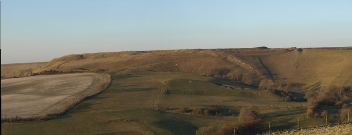

 Maps / Plans / Diagrams:
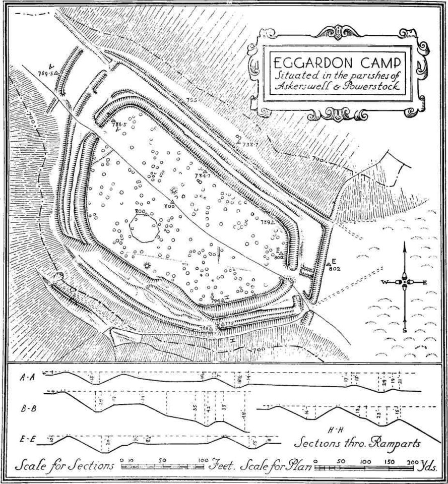
|
Fieldnotes |
|
|
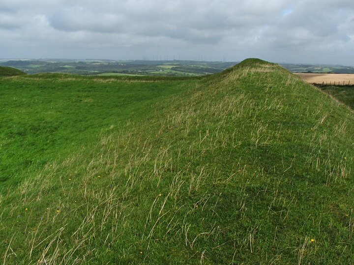
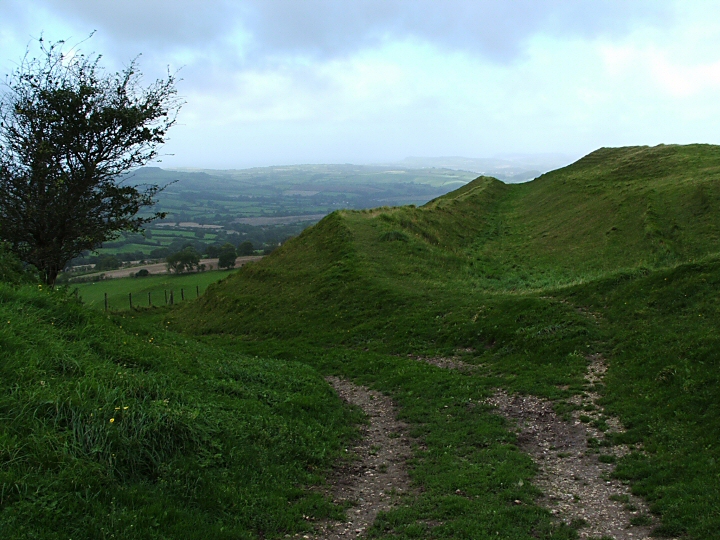
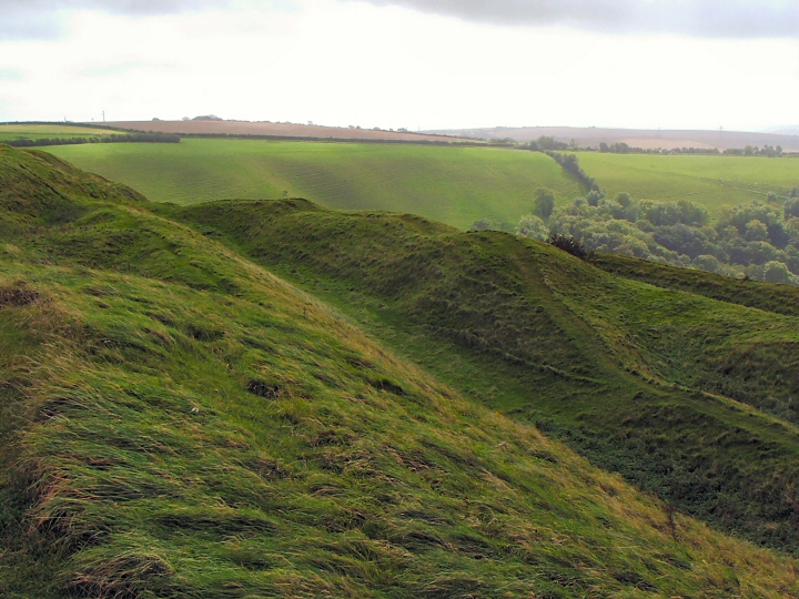
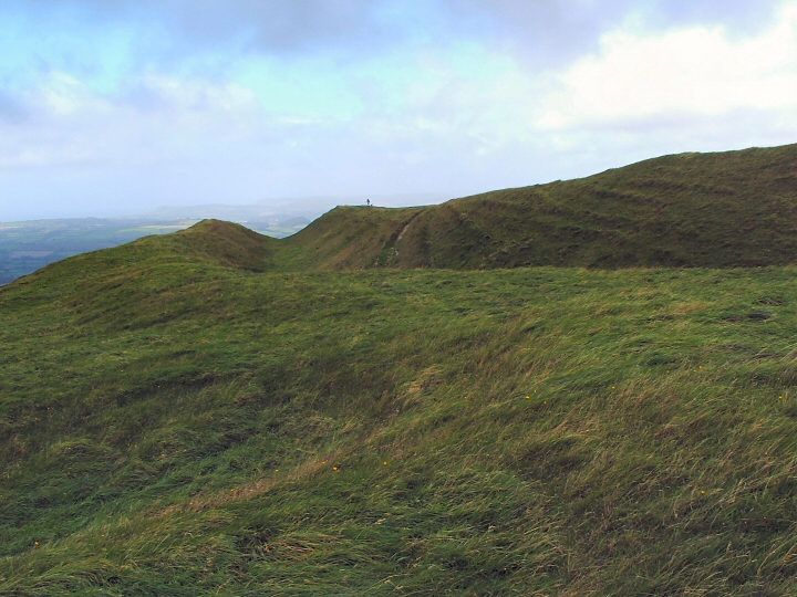
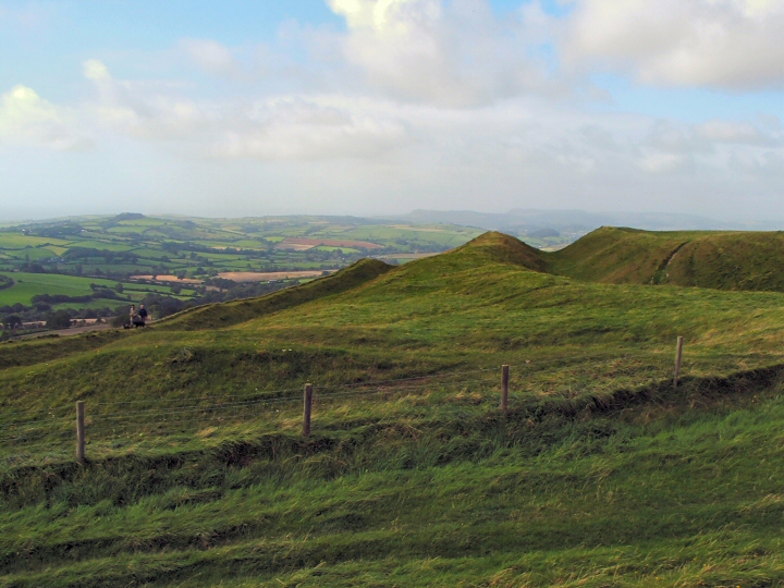
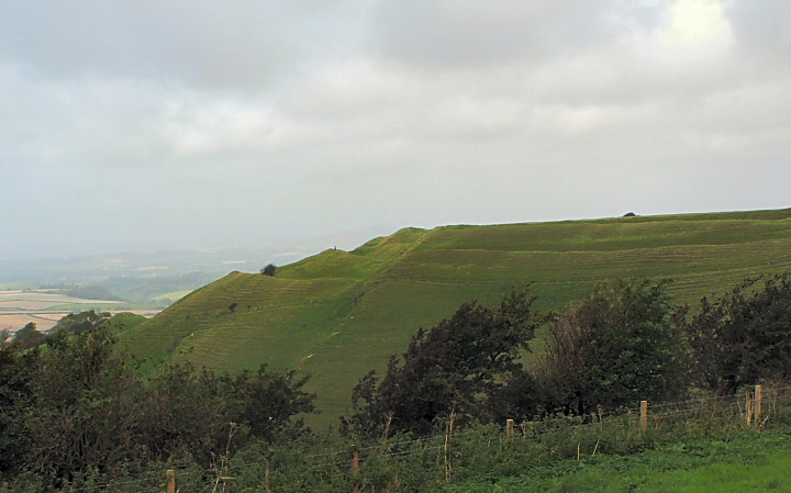
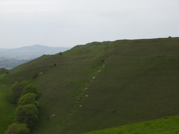
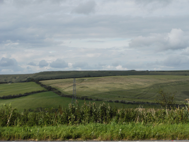
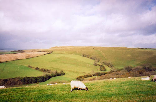
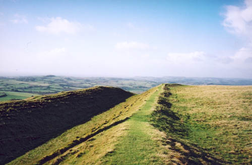
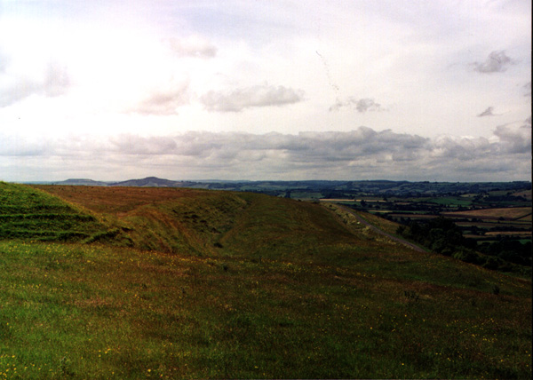
Visited 13.10.12 WOW – what a great Hillfort to visit this is! Directions: Come off the A35 and take the minor road north through the village of Askerswell. When you come to the crossroads take the turning to the right and follow the road north which takes you to the Hillfort. There is a parking area just to the SE of the Hillfort. This is a N.T. site to access is not a problem with a permissive footpath running right through the site. There is an information board near the stile leading into the Hillfort. I was surprised by how well this Hillfort is preserved. It reminded me very much of a mini Maiden Castle (which isn’t too far away). The ditches/ramparts at the southern end are still very impressive – the ditch being about 3m deep and the bank rising to about 6m from the bottom of the ditch. I walked anti-clockwise around the Hillfort and kept a look out for the two Barrows the information board said were in the middle of the site. It was a lovely day for the time of year with blue skies and lots of white fluffy clouds. Windy as you would expect at a Hillfort. There was one mean looking black cloud heading straight for me and I could already see the rain falling from it – time to retreat back to the car! The views are great and so is the Hillfort. This Hillfort should be a ‘must see’ when in the area – visit if you can. |
Posted by CARL 18th October 2012ce |
|
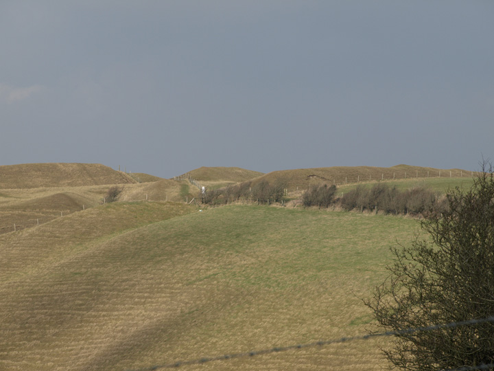
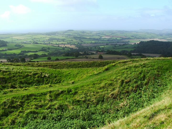
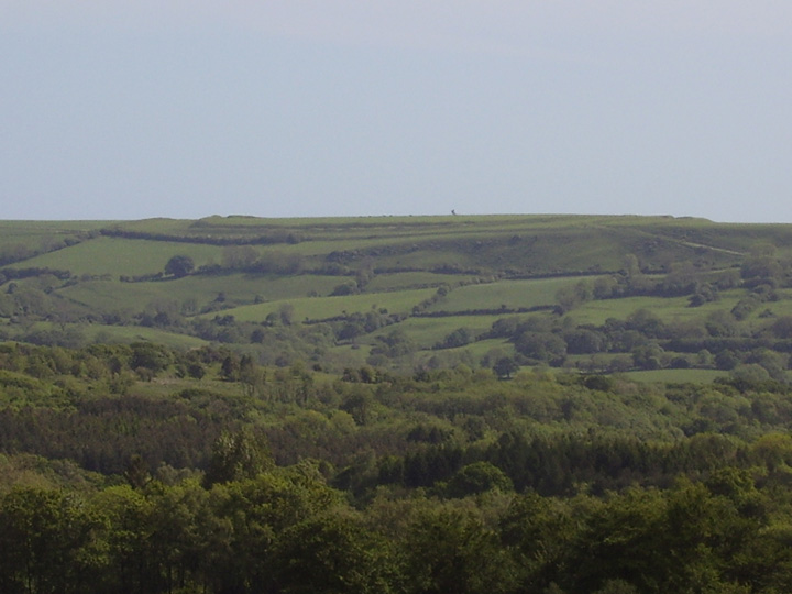
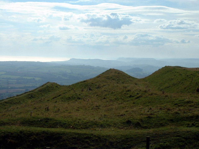
Don't you find it interesting when something that strikes you about a site isn't mentioned at all in other people's fieldnotes. For me, one of the things here is the Dorset coast stretching out into the distance. Maybe that's because I've spent 95% of my life a long way from the sea, so I enjoy it more when I see it. But for me it gave the massive view a bit of a focus and more of a sense of distance. We'd been down on the weird Chesil Beach earlier (with its curiously sorted pebbles, pea size at West Bay, potato size at Portland, said the notice) and bits were still dropping out of my pockets when we got up here on the hill. I wondered what the prehistoric inhabitants would have thought. You couldn't live this near the sea and not eat fish now and again. The view completely distracted me from the slope below (I didn't realise its suicidal steepness until we were driving back down and I saw it from afar). It's got a rather similar feel to Westbury with its dry chalk undulations. The other thing that really grabbed me was something you can only see from the northwest point of the fort. It's a line of rocks sticking out from the hillside ahead. It's a curious looking thing, I mean obviously it's some strata of harder rocks, but it's strange, a ledge jutting out from the smooth slope. I felt certain it should have a name, and looking on the map afterwards I see it does: Bell Stone. oh how there must be / must have been a story to go with it. John Curtis has a photo as I saw it from the hill on Panoramio; also a close up here. Also I was interested to notice a bronze age barrow (cut in quarters like a currant bun by some treasure hunter no doubt) - it was interesting to think it was preserved by the later builders of the fort. And speaking of barrows, there's what I took to be a massive disc barrow next to the road - obvious enough to draw the eye. Practicalities: the turnings off the A35 are tiny and easy to miss but we came off at Askerswell and parked at the top of the hill in a sort of decently offroad council-approved spot at SY549948. Then you can walk in a level straight line across a couple of fields (hopping the stiles) to end up at the original entrance to the fort. You do have to climb up a bit to get in though - as if the almost encircling slopes weren't enough defence. And there are some lovely brownish sheep up there at the moment, with curly horns, I suppose they are looking after the chalk grassland for the National Trust. |
 Posted by Rhiannon
23rd September 2012ce Edited 24th September 2012ce |
|
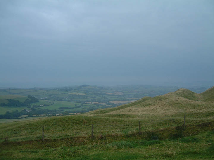
Tremendously impressive ditches and banks on this large site, unfortunately, as others have mentioned, you do need decent weather up here. We were greeted by a ferocious gale which made exploring the site very difficult and one wonders how the original inhabitants dealt with inclement weather. Any future research and/or excavation here should be very interesting indeed, if, as noted, much of the site has never been ploughed. Access Small layby to the SE. Short level walk to entrance, gate, modest slope to interior. |
 Posted by jimit
2nd October 2008ce Edited 2nd October 2008ce |
|
Like views? Like hillforts? You'll love Eggardon Hill. After a very wet & very foggy w/e in Askerswell, the weather cleared just in time for me to drag the missus up here on the sunday morning. Amazing views to the North, South and West, its one of the few places in Dorset where you really feel "up high". As a fort it is highly impressive, not quite so as Maiden Castle but almost certainly the second best in this area, and defn. worth a visit for the ramparts alone. A fence runs straight through the middle of this fort which kinda spoils the effect but you can access the entirity, once you find that elusive gate to the second side. On your way in (or out) have a quick look at what I took to be a guard post to the east of the fort, next to what we used as a carpark... |
 Posted by juamei
7th November 2002ce |
|
on our holidays in deepest dorset we came from beaminster, choosing one of the loveliest little roads we have ever seen: eastwards from beaminster via mapperton and (don't miss the tiny road!)west milton to powerstock - an then alongside eggardun: what an experience to have one of the most beautiful parts of dorset on your left and the mighty hill on your right. parked our car on the top of the and wandered lonely as a cloud towards eggardun. magificent, sublime is the view from here: you can guess the sea in the south an marshwood vale in the west. very quiet up there, except for the wind that takes the outer life away - even more quiet, if you disappear in one of the huge ditches. were i forced to live my furher life as a cow, i would prefer to live between the cows grazing on eggardun hill. just visit eggardun - surely one of the most impressive places in southern england where we ever have been. |
Posted by roderich 5th September 2001ce |
|
EGGARDUN - Visited 20/4/00 We arrived at the fort with it shrouded with fog. After dicing with death along the narrow road encircling it, we parked and headed up to the top. With the fog blocking the view all around, we contented ourselves with exploring the fort itself and located a strange octagonal feature shown on aerial photographs...a henge, an enclosure...who knows..? |
 Posted by Rob Gillespie
15th January 2001ce |
Folklore |
|
Even people who've known the hill all their lives can find it has a strange and unpleasant atmosphere sometimes. Harry Poole's account is at the Dorset Books website. There's plenty of reading between the lines that needs to be done.I thought I knew the Hill and all its moods after half a lifetime of toiling on its steep sides but this was a new facet, one that I had not come across before. The chilly atmosphere had become oppressive and there was something different, something strange, something which took my concentration for a moment. It came between me and the job I was doing and I cannot account for it try as I will. It’s no good saying you should be more careful. I’ve been using edge tools for over fifty years and apart from an accident with a circular saw which was my own fault, nothing like this has happened before...There are many of his stories on the website about the area. It's rather nice that you can't always tell the line between fact, memory and imagination. |
Posted by Rhiannon 17th July 2010ce Edited 23rd September 2012ce |
|
Perhaps this is the tale Purejoy hints at below. It was described by Edward Waring in his 1977 'Ghosts and Legends of the Dorset Countryside'. A farmer was out on the hill late one night, when he heard in the distance the sound of a huntsman's horn, and the baying of a pack of hounds. Looking across he saw 'the form of a man running for dear life' through a hedge and ditch. The hounds appeared next, 'urged on by a tall black figure striding at an unearthly pace, with sparks of fire flashing from his boots'. They seized their quarry before he got down into the valley and the farmer realized that what he had seen 'must be the Devil tormenting a lost soul'. Nice turns of phrase. Quoted by Westwood and Simpson in their 2005 'Lore of the Land'. |
Posted by Rhiannon 24th February 2006ce Edited 24th February 2006ce |
|
This weird story is described in 'The Secret Country' by J and C Bord. One evening in September 1974, Michael Byatt (a registered gliding instructor and senior NCO in the Air Training Corps) was driving his car up over Eggardon. Suddenly the engine began to lose power, and the headlights dimmed. He and his passenger became intensely cold and 'felt an eerie presence'. In the sky they saw a yellow-blue [sic] light 'in the form of an eclipse' [sic - an elipse?]. It moved slowly backwards and forwards and 'had a sort of glow about it'. A couple of years earlier three cars climbing the hill at night had simultaneously stopped suddenly; they had no power and no lights, but these returned after a short time. Ooh sounds like your typical UFO incident.. or dodgy alternators. |
Posted by Rhiannon 15th July 2004ce |
| A man was supposed to have been chased by the Devil across this Iron Age hillfort. I've also read about the Diana one mentioned below. |
 Posted by pure joy
19th March 2003ce |
|
It is said that Diana the Moon Goddess, leads a ghostly hunt of fairies, demons and witches over the summit of the ancient hillfort collecting the souls of the dead. http://www.darkdorset.co.uk |
Posted by Mizmaze 1st October 2002ce |
|
local saying… "As old as Eggardon" |
Posted by phil 30th August 2002ce |
Miscellaneous |
|
The farmers' sons and daughters of the parishes surrounding Eggardon Hill held their annual private picnic on the hill on Whit-Monday, and were joined by a number of friends from a distance. The Askerswell band was in attendance, and dancing commenced shortly after four o'clock. During the evening a great number of persons went on the top of the hill to enjoy the extensive scenery. About six o'clock they all sat down to an excellent tea, and as evening drew on the band played almost without ceasing, and dancing was kept up with great spirit. Through the kindness of the Misses Toleman, of Witherstone, and Misses Wrixton, of King's, there was an abundance of refreshments. The party broke up about 11 o'clock, and left the hill cheering and congratulating each other upon their evening's enjoyment.Fun on the hill reported in the 20th June edition of the Bridport News, 1868. |
Posted by Rhiannon 25th May 2017ce |
|
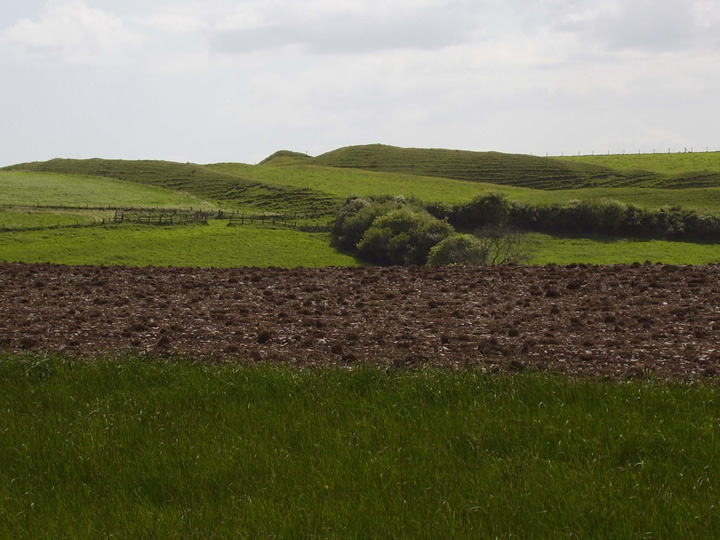
Details of Hill Fort on Pastscape CAMP [OE] (1) Iron Age Hill Fort. (2) A hillfort consisting of 3 ramparts with 2 medial ditches, except at the N.W. and E. where entrances occur. The N.W. entrance has an additional outer bank, ditch and counterscarp across the ridge, merging into the main line of defence. The entrance is staggered from one line of defence to the next. At the E. end the main rampart is higher than elsewhere, and has an outer ditch and counterscarp bank. The entrance ways are again staggered, and in the outer rampart, inturned. "On the S. side of the hillfort an extensive landslip carried away the whole of the defences on the middle of this face; this was remedied by digging a wide trench in the E. part of the fallen material, and, reinstating the outer ditch and bank below it." This part of the earthwork does not connect with the earlier defences. A further bank thrown up at the foot of the hill covers roughly the lateral extent of the landslip. Through this bank the diagonal approach to the S.E. entrance turns outwards and southwards. There is no visible evidence that the multiple defences were preceded by a simpler system. Apart from the rebuilding of the S. side, evidence of a structural sequence has been noted at the N.W. end, where the alteration of the position of the outer entrance coincided with the addition of an outer enclosure. Within the hillfort are 2 large mounds, probably barrows and a number of small irregular mounds. There are traces of banks, perhaps of enclosures, and many hollows, 4 to 5 yds in diameter. In 1900 five of these hollows were excavated, and found to be pits from 5ft. 6ins to 6ft. 8ins deep. In them were found a flint knife, saw, scrapers and numerous flakes (4a). The octagonal enclosure bank within the hillfort is the boundary of a former coppice planted to serve as a sea-mark. (4) [Additional references]; (5) the floor of the camp is strewn with pit dwellings; other information similar. (6) A sherd and a rock hone from Eggardon, presented by Mr W. Butcher, Higher Sturthill, Shipton Gorge. Acc. No. 1954.29. (7) "Fosses, mounds and pit-circles occur both within and without "the fortifications of the hill-fort," and one remarkable pit circle consisting of two distinct depressions connected by a common entrance". (9) In an early excavation of one of the hut circles a broken quern was found by Mr Prideaux. (10) Reference to a treble row of depressions, some sixty in number, which existed "behind the top vallum". The depressions were later destroyed by gravel digging. (11) [Reference (4)a checked: flints and flakes and pits classified Neolithic; but "no pit is cut by the walls of the camp."]. Eggardun has at least yielded apparent IA 'A' material, though complex defences suggest a sequence of occupations and plans. Its excavators considered it Ne. but this was before the recognition of true Ne. features in either earthwork or pottery. Its pit dwellings are I.A 'A' and the associated flint industry occurs elsewhere in I.A. settlements, though the variations of its prevalance have yet to be explained. Invaders from the W - I.A. 'B' - perhaps remodelled the hillfort. (12) This hillfort is well described in TA (4) and depicted in the photo-plan. The O.S. 1/2500 is generally correct; a minor scarp shown on the photo-plan on the S. part of the ramparts (lettered A-B on sheet) appears to be caused by natural soil-creep. The condition of the hillfort is good, with strong multiple banks and ditches and staggered entrances. The area enclosed by the ramparts is ploughed in the N. half, but the S. half is under pasture. Scores of surface depressions (from T4, IA 'A' pits) are visible over the surface; these are 3.0m. to 5.0m. in diameter and 0.2 to 0.5m. deep, though less definite where ploughed. No surface finds were made during field investigation. See APs. ST J/AX 87-9; BZ/63-5 (13) (A plentiful water supply is available in close proximity to this feature). (14) The Butcher collection includes several sling stones and some pottery from ploughing 50 yards NW of the rampart (SY 539950). The pottery appears to be Iron Age "A" in character. (15) From aerial photographs, it appears that the outer rampart on the NE side of the fort was either left incomplete, or slighted after construction. (16) The site was excavated between 1963 and 1966 by G. Rybot. The linear banks are thought to pre-date the middle-late Iron Age. Excavated pits contained middle-late Iron Age pottery. (17) Supplementary notes, plan correspondence and photographs. (18) Sling-stone and part of a rotary quern found at the Western approach to the fort. (19) |
 Posted by Chance
29th March 2016ce |
|
(12) Eggardon Camp, hill-fort (Plate 71), partly in Powerstock parish, occupies the summit of a hill 800 ft. high, 1½ m. N.E. of the church. The area is over 20 acres, or nearly 36 acres including the defences but excluding the outwork on the S.W. The hill-fort has a comparatively level enclosure but the ground falls rapidly on the N.E., S., S.W. and W., though to the E. and N.W. it is nearly level. The defences, except on the E. and N.W., consist of three ramparts with two medial ditches; on the W., N.E. and E. sides there is an open area of varying width between the two outer lines. At the N.W. and E. ends, where the ground is practically level and the two entrances to the camp are situated, a different treatment is adopted. The former has an additional outer line of rampart, ditch and counterscarp bank, across the back of the ridge and merging into the main outer line of defence. As will be seen from the plan the entrances through these ramparts are so arranged as to traverse the defences diagonally. There are two entrances through the middle rampart; the central entrance has an inturn on the N. side but the ditch has been cut through in front of it, probably when the second entrance to the N. was formed. This entrance is approached by a sunk track along the edge of the ridge to the N.W. The outermost line is stopped short of this approach and is therefore presumably an addition to the plan, contemporary with the building or extension of the outermost rampart on both sides of the ridge. At the E. end, the main rampart is higher than elsewhere and has an outer ditch and a slight counterscarp bank. The entrance through the outer line is in the S.E. angle and is flanked by inturned ramparts. Here also the entrances are made to traverse the defences diagonally, additional strength being obtained by the formation of two ramparts with a medial ditch across the enclosure between the two systems. The outer entrance was approached both from the ridge and also by a diagonal track up the S. escarpment of the hill; where this track approaches the entrance it is screened by a short length of outer bank and ditch. On the S. side of the fort an extensive landslip carried away the whole of the defences on the middle of this face; this was remedied by digging a wide ditch in the eastern part of the fallen material and reinstating the outer ditch and bank below it. Neither of these works, however, being at a lower level, make connection with the earlier defences. As part of the same work a further bank was thrown up at the foot of the hill and covering roughly the same lateral extent as the landslip. Through this bank the diagonal approach to the S.E. entrance turns outwards and southwards. Although no reconstruction of the history of the site is possible without further excavation, evidence of a structural sequence has been noted both at the N.W. end and on the S.Side. In the case of the former, the alteration of the position of the outer entrance coincided with the addition of an outer enclosure. On the S. side, the rebuilding of much of the outer defences, due to the landslip, doubtless explains the presence of the unusual outer line of considerable strength in the valley below it. There is no visible evidence that the multiple defences were preceded by a simpler system. Within the enclosure are two large mounds, probably barrows, that marked " A " on plan having a diameter of 42 ft. and a height of about 2 ft.; while mound "B" has a diameter of about 42 ft. and a height of 4½ ft. Both have been considerably damaged. There are also a number of small somewhat irregular mounds. Their dimensions are as follows:—(1) disturbed in centre, diam. 23 ft., height 9 in. (2) irregular oval 6 ft. by 5 ft., 6 in. high, possibly natural. (3) oval, diams. 6 ft.by 5½ ft., height about 8 in. (4) roughly circular, 12 ft. diam., height about 9 in. (5) roughly circular, 10½ ft. diam., height about 9 in. (6) rectangular, 19½ ft. by 9 ft., height about 9 in. (7) rectangular, 45 ft. by 9 ft. and 1 ft. high, possibly a portion of a bank. There are also, where shown on plan, traces of banks, perhaps of former enclosures, but they are now somewhat fragmentary and it is impossible to say whether they are original. It is perhaps significant that, as far as can now be seen these banks do not appear to impinge on any trace of a pit. The small octagonal enclosure, surrounded by a slight bank, some 50 yards from the S.W. rampart, is modern. It represents the site of a former coppice planted to serve as a sea-mark. The whole floor of the main enclosure is pitted with shallow cup-like hollows in the turf about 4 to 5 yards in diam. Generally speaking, there is no trace of their having been arranged on any direct system beyond the fact that they appear to have been kept clear of the central trackway joining the two entrances. This observation must, however, be qualified by the fact that a modern trackway runs on this line. During 1900 five of these hollows were excavated (Dr. Colley March, Proc. Soc. Ant.,XVIII, p. 258). They were pits varying in depth from 5 ft. 6 in. to 6 ft. 8 in. In them were found: a flint knife, flint saw, scrapers and numerous flakes, etc. The ridge on which the camp stands narrows, until it ceases in a rapid fall about 600 yards N.W. of the camp. On the top of this ridge about ¼ mile from the outermost rampart of the camp and a few yards N.W. of the O.S. Trig. point is a slight sinking of about 5 yards diam. and 2½ ft. deep with slight encircling bank. About 20 yards W. of this is a rough transverse ditch across the top of the ridge which here is only about 23 yards in width, with an internal and external bank. 'Askerswell', in An Inventory of the Historical Monuments in Dorset, Volume 1, West (London, 1952), pp. 12-15. British History Online http://www.british-history.ac.uk/rchme/dorset/vol1/pp12-15 |
Posted by Chance 29th March 2016ce |
| The hexagonal mark noted in Rob Gillespie's fieldnotes is reckoned to be the mark left by a plantation of trees . These were supposedly planted by the owner at the time , who was a naval captain , he is said to have used them as landmark to be seen from the sea . Sounds a bit dodgy to me , but not completely barking mad. |
 Posted by formicaant
23rd April 2007ce Edited 23rd April 2007ce |
|
The National Trust booklet 'The Cerne Giant & Dorset Hill-Forts' (2000) which is definately available at the Kingston Lacy house and might be available at other Dorset properties, gives the following directions to the hill fort at Eggardon Hill, "From Dorchester take the main road west (A35) towards Bridport......At first the Bridport road follows the Roman road and is characteristically straight. After 5km the main road leaves the old route and drops down into the village of Winterbourne Abbas. The Roman road still exists as a minor road cutting across the downland towards the ancient landmark of Eggardon. Take this quiet road. After 5km the ramparts of the hill-fort are visible at a crossroads. Turn left here towards Askerwell and drive for 200m. Park in the lay-by on the left. Cross the road and take the footpath towards the southern ramparts". It adds that the name 'Eggardon' is an Old English place name, the hill or down belonging to a man called Eohhere. The earliest documented reference to the place name dates from the Domesday Book in 1086. |
Posted by pure joy 12th April 2004ce |
|
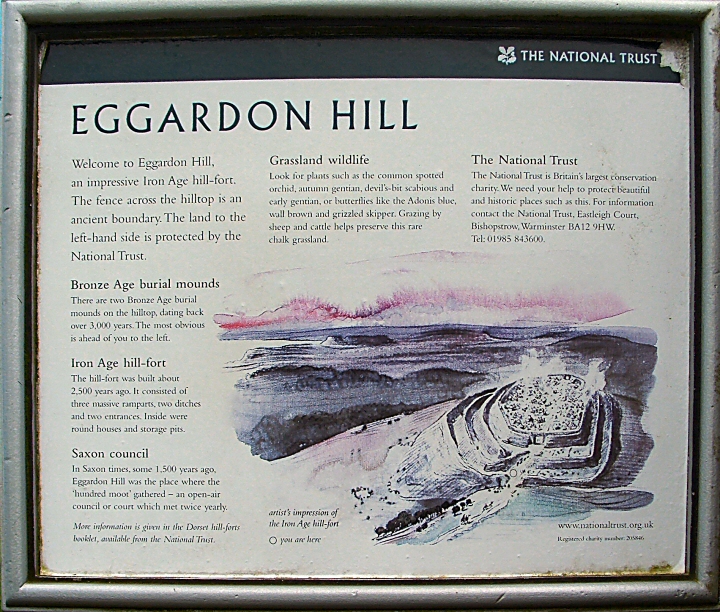
The hill-top at Eggardon is crowned with the impressive ramparts and ditches of one of Dorset's best preserved hill-forts. Dating from the Iron Age over 2,000 years ago, this fort has not been excavated in modern times and much of its archaeology remains hidden. The fort covers nearly 40 acres of the hill-top, its defences following the hill-slope on three sides and dramatically cutting off the fourth. Half of the interior seems never to have been ploughed. |
Posted by phil 2nd January 2002ce Edited 24th March 2013ce |