|
|

|
|
Oldbury Rock SheltersCave / Rock Shelter
|
|
|
|
Images (click to view fullsize) |
|
Photographs: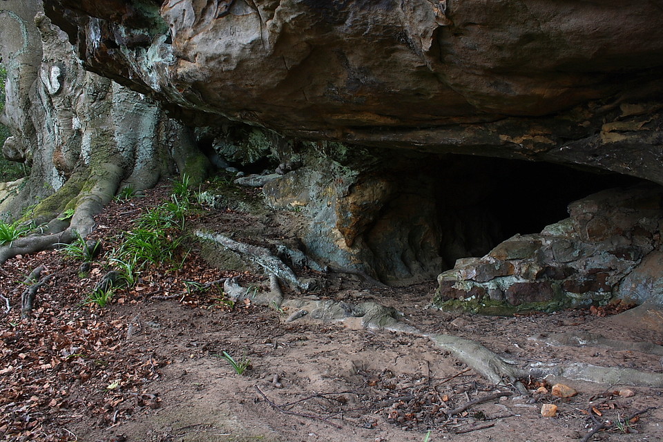
 Maps / Plans / Diagrams:
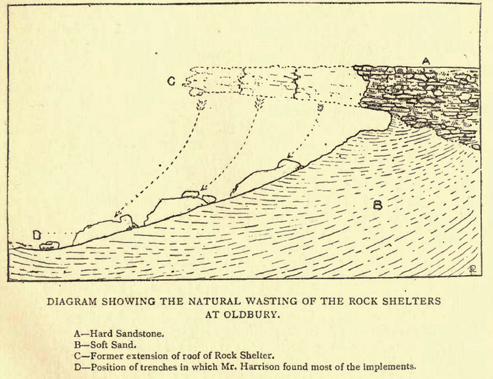
|
Fieldnotes |
|
|
After studying all the previous posts I decided to attempt to locate these two sites. On Tuesday this week we made the climb from the car park using the recommmended route but losing our bearings we had to give up the search. On checking other sites and using my car Tomtom in longtitude/ latitude mode we set out again. I realise I made an elementary mistake which was mentioned and went on the wrong path. We found both sites quite easily and on the rock dwelling on the path from Oldbury Lane my sat nav was out by only 50 yards which I found amazing. Well worth the climb but I have to say I did not feel any atmosphere at the dwellings but other obviously have because of the evidence left behind. David |
Posted by deepeedee 9th May 2013ce |
|
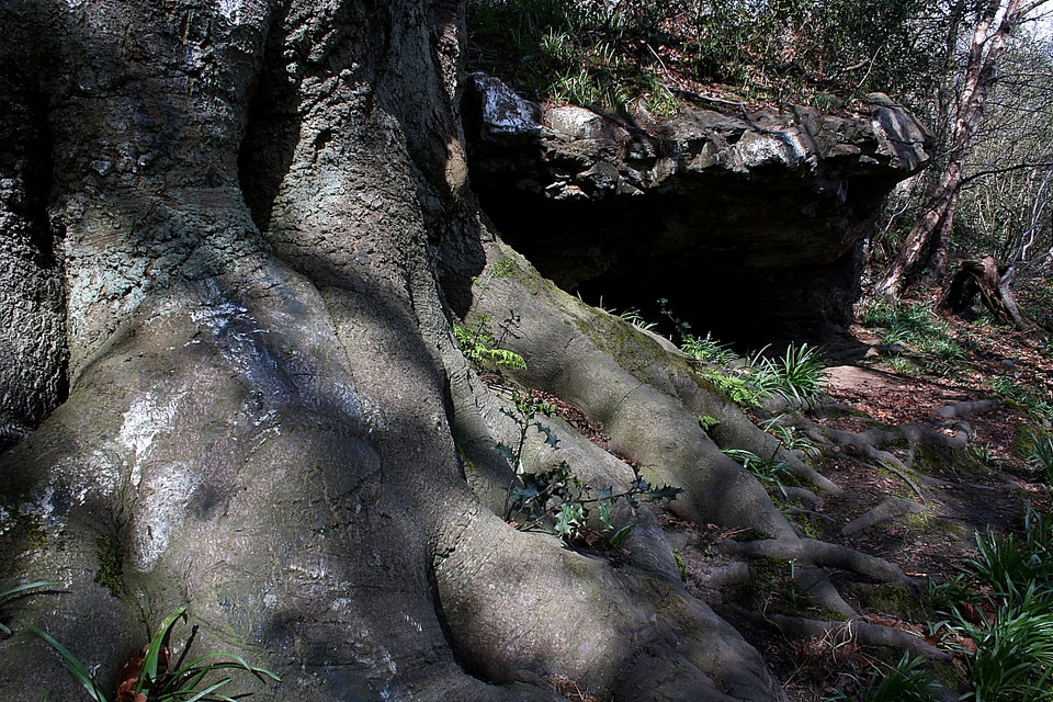
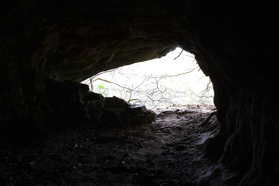
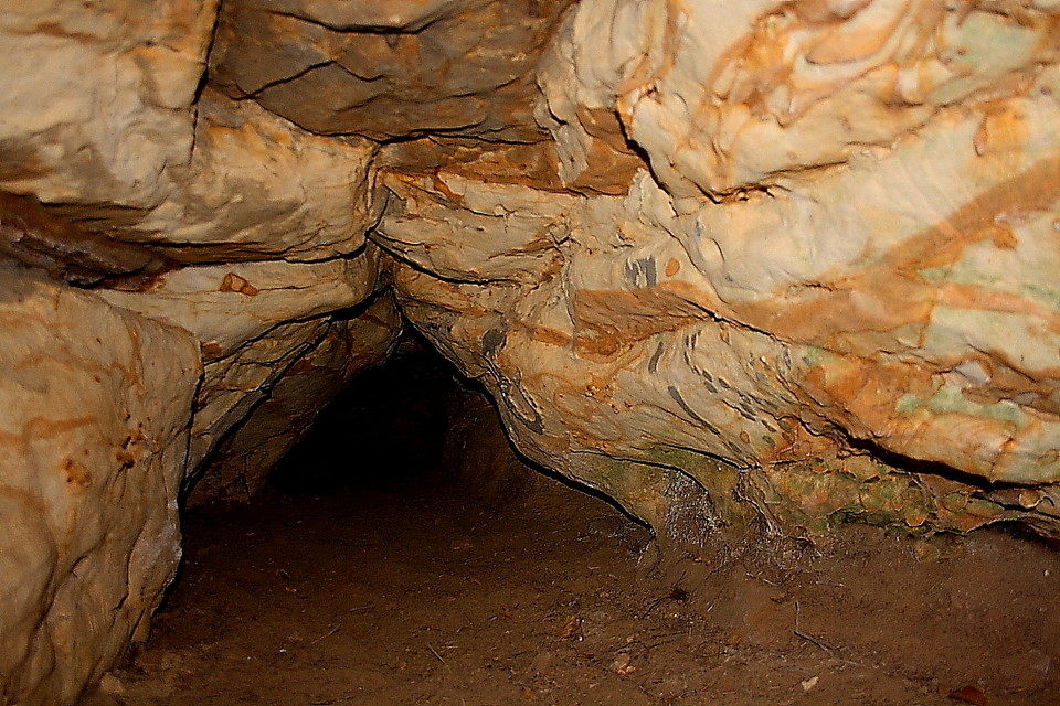
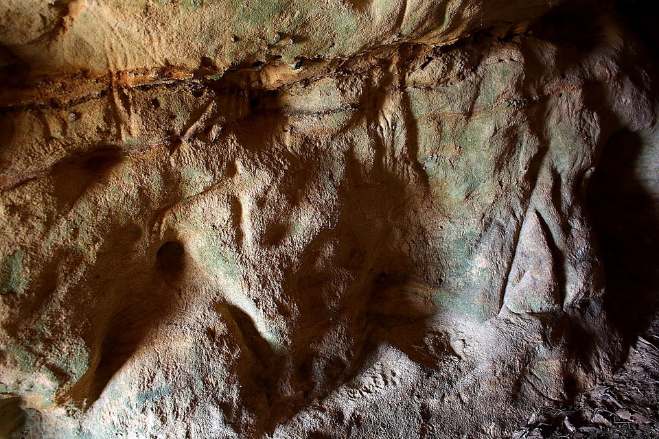
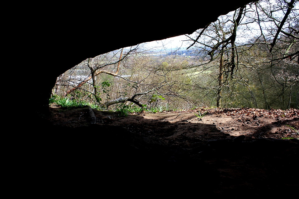
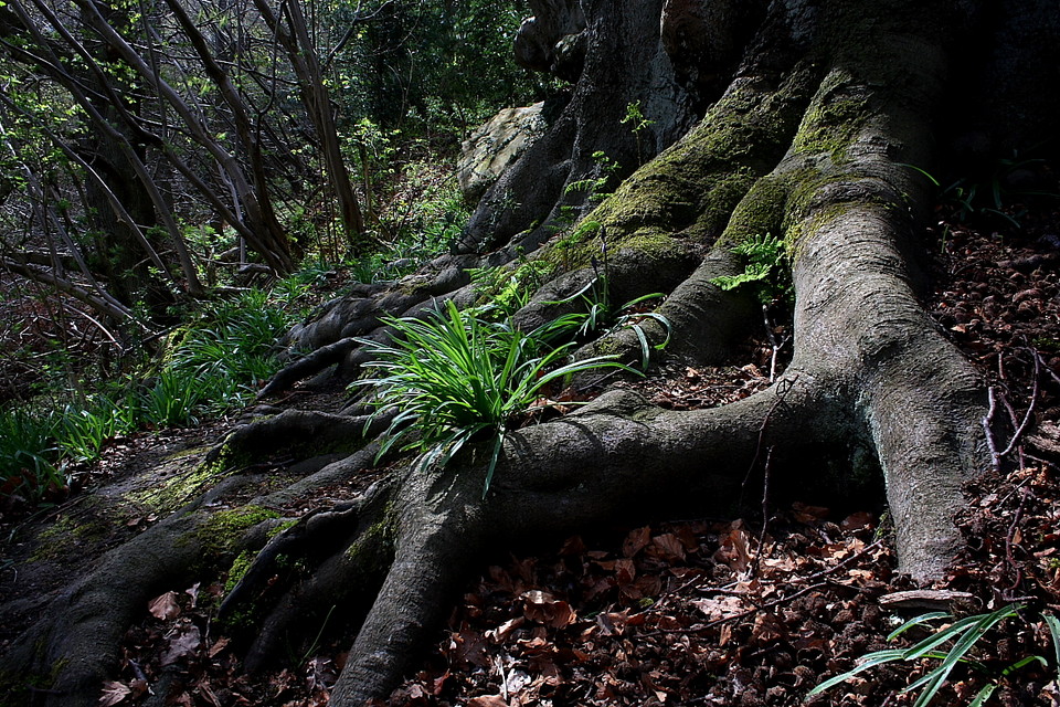
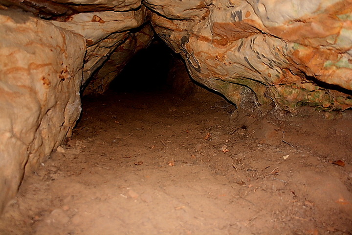
The perimeter of Oldbury hillfort is so substantial... of such extreme length.... a 'hill city', in fact... that my only previous visit here, in 2008, merely focussed upon the well defined defences to the south. Yeah, 'I'm a lazy sod', a phrase once used to great ironic effect by Johnny Lydon when taunting the British establishment out of its own stupefaction. But, credit where due, a few years on I realise my mistake and reckon... at the very least... the bluebells might have made an appearance upon the ancient ramparts once again, earthworks which I understand could possibly - nay, probably - have succumbed to an assault by Caesar and his barbarian boneheads during the course of his self-aggrandizing trip across the water from Gaul. Why not try the whole two and a half-odd miles. Angry farmers permitting? Yeah, why not? The enormous Iron Age fortress of Oldbury rises above the Kentish village of Igtham, famed - and rightly so - for its exquiste, moated Medieval manor house. Not that the informed passer by would know the former existed at all, if not for the name. Oldbury... hmm. So where's the 'fort, then? A dense encircling canopy of trees is the culpruit here, predominately oak, or so I understand. Well, to cut a long story short - even with map and compass - I soon lose any sense of positionning upon this tremendous fortification. Yeah, I'm soon bewitched by the ancient forest, so I am. The defences are pretty upstanding for the most - as mentioned, very much so to the south - but have the tendency to go walkabout in places (or so it seems). Some may find woodland claustrophobic, but not I. Love it, the roots of trees clinging to rampart sheltering the aforementioned first bluebells of Spring, the wooden tentacles themselves the very epitome of Nature. I blunder into an orchard and notice the path continues, a couple noncholantly walking a dog.... beyond, the tree line is bordered by a mass of farm implements... not to mention council road signs. Hey, use an ancient hillfort as a storage depot, why don't you? Guess this must be the 'private' part, then? Carrying on along the edge of the hillside I encounter some rocky outcrops...... no, couldn't be? Aren't there supposed to be some cave dwellings here? There are. And for a reason I can't really explain the experience completely blows me away. Overlooking a steep drop and accompanied by another fine tree with copious roots, I gaze into the black void and know I must brave the arachnids and venture inside. There is no choice. I must.... and, although well versed in crawling down the claustrophobic passages of Orcadian tombs, I begin to freak out within. What appear - at least to me - 'artificial' markings upon the left hand cave wall heighten the vibe, the darkness beyond showing the literal 'light at the end of the tunnel'. To my suprise - aren't caves damp and uncomfortable? - the ground is absolutely bone dry, powder dust, but the roof is perhaps just three foot high. Good for sleeping, then. Hey, much like my one man tent? These Neanderthal fellas (and lasses) had their world sussed, methinks. Although light beckons, the roof begins to contract to a point where I can't go on. No, really. Approx half way, I guess. Retreating towards the entrance I gaze out and am suddenly overwhelmed by a connection to what went before. Hey, the finds prove it. People sat here at a time beyond my comprehension... people of a different species, goddammit!.... and no doubt thought 'look at that bloody rain... and she's gonna kill me if I don't return from the hunt with something better than that bloody squirrel yesterday.... Mighty hunter... me. Ha!' I sit at the entrance, beneath the overhanging rock protecting the fire... if there was one... eating my pre-packaged lunch... and wonder how I'd cope if I actually had to catch my own lunch. Yeah, I'm sure I could do it. Do or die. But how dare we be-little the people who've gone before. How dare we!! How dare we, indeed..... I sit here in awe, I really do. The birds sing, and perhaps only the distant road noise reminds the traveller this is actually the 21st century.... how can one experience such emotions in quaint modern day Kent, American tourists swarming below? I feel red raw with emotion. And mighty better for it, I can tell you. |
 Posted by GLADMAN
16th April 2012ce Edited 17th April 2012ce |
|
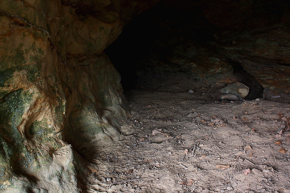
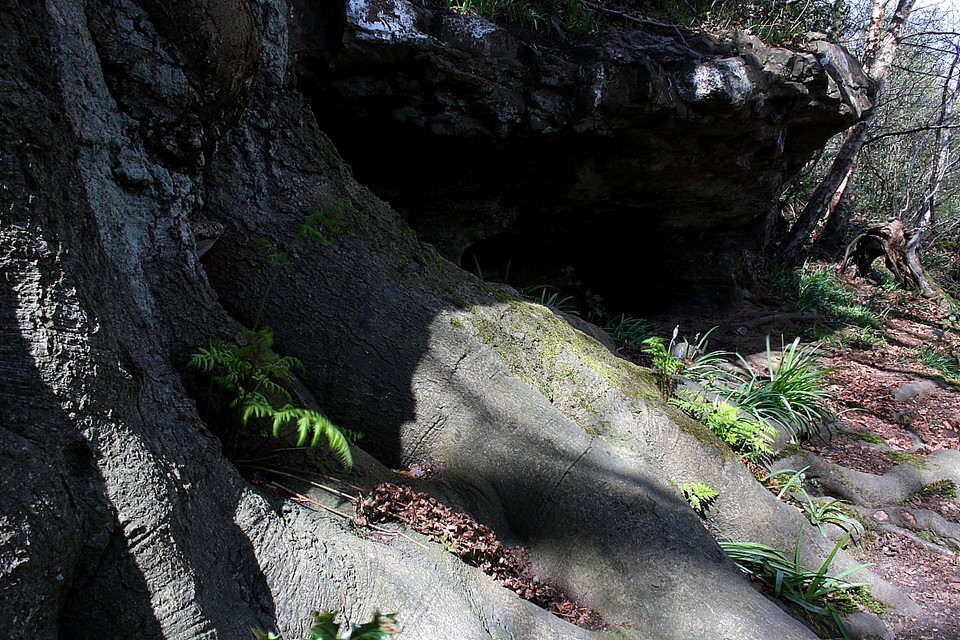
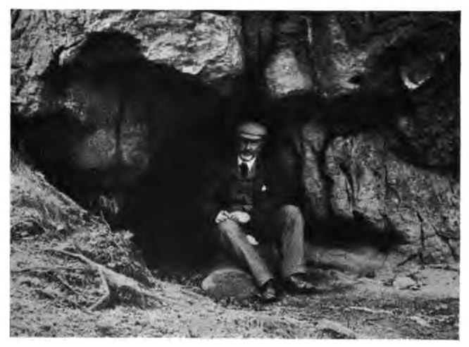
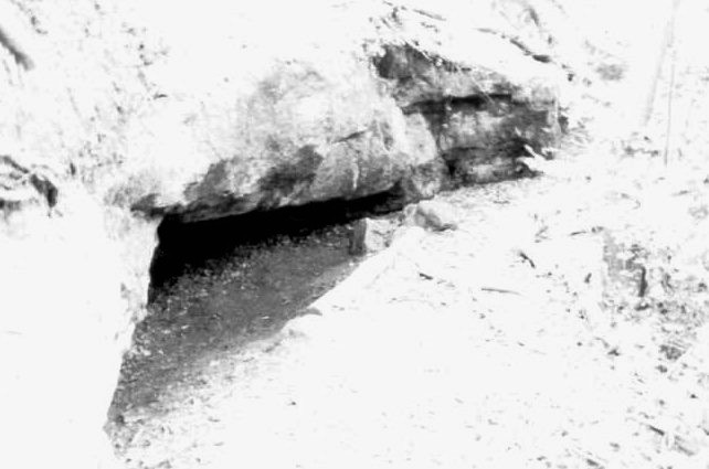
Regarding the rock shelters, we learned a lot from local archaeologist Angela Muthana, and from Sir Edward Harrison's article 'Oldbury Hill, Ightham' in Archaeologia Cantiana (45, 1933, pp. 142-161), most of which corrected what we had through we knew before. Mesolithic tools have been found around the area, and people may have sheltered under Oldbury Hill's rocks in that period, but the rock shelters are most closely associated with the very end of the Middle Palaeolithic, specifically about 60,000-40,000 years ago, and thus with Neandertals, as there were no Homo Sapiens here at the time. The discovery was made by Benjamin Harrison (1837-1921), the grocer in the nearby village of Ightham. He had found many ancient tools around Ightham, but realized that they were particularly associated with the hill and its outcrops of greenstone (so coloured because of it contains glauconite, that turns a slight green on exposure to the air). These greenstone rocks overlay a softer sandstone, that, when exposed, were liable to greater erosion than the harder rock above, leading to the greenstone overhanging a space below and forming shelters. In two spots, small caves had been dug into the sandstone as well, though at what period it is difficult to say. In 1870, Harrison was electrified by seeing the London exhibition of Neandertal finds from Le Moustier, France. He recognized the similarity of the tools to those from Ightham, and reasoned that the rocks of Oldbury Hill may have been home to Neandertals just as the cave of Le Moustier had been. His great discovery, in 1890 with help from the British Association for the Advancement of Science, was a Neandertal flint-scatter at Mount Pleasant, on the slopes the north-eastern side of the hill (the precise site of which has not been rediscovered, despite several archaeological digs), directly below a rocky outcrop that is now much reduced by 19th century quarrying. Here, he found '49 well-finished implements or portions of them and 648 waste flakes have been found at this spot, leading', as he wrote in his report (co-authored by Dr John Evans, father of Sir Arthur, Dr Joseph Prestwich, who lived at nearby Shoreham, and H.G. Seeley), 'to the supposition either that this was the frontage of a rock shelter, or that the material had slipped down from above'. It is on this basis that Harrison reasoned that the Neandertals, like those of Le Moustier, had made flint tools here and would most likely have sheltered under the rocks. That is the sum total of the evidence: no Neandertal remains have been found at the rock shelter. The rock shelter is on the edge of the hill's plateau (and the edge of the hillfort: the fortifications at this point have been largely destroyed by the 19th century quarrying). There are several other points around the hillfort where there are exposed rocks: some of these may have been shelters as well. A considerable cave (5' high and about 14 or 20 yards deep) used to exist on the south east side of the hill, presumably partly, at least, burrowed out by humans, but this was destroyed by quarrying. However, some of the rocks we see now may only have been exposed when the hillfort was made. What looks like a good shelter, on the right of the path going up to the ramparts from the top of Oldbury Lane, and which could easily be mistaken for an ancient rock shelter, may actually have been exposed only when the path and nearby steps were cut by the Victorians. Oldbury Hill is within easy striking distance of London. It has impressive Iron Age fortifications, and is closely linked to Neandertals. Who needs Time Machines? |
 Posted by Anthony Adolph
26th April 2010ce Edited 26th April 2010ce |
|
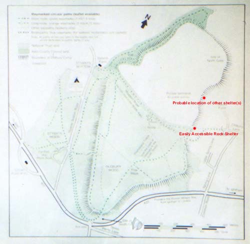
Oldbury Rock Shelters – 25.8.2003 WOW – wow wow wow. These are cool. They were occupied in the Middle Mesolithic period (100,000BC to 30,000 BC) The southern one I found with Juamei’s instructions. The shelter is just off the path marked at both ends by small concrete plaques marked ‘Public Bridleway’ (i.e. not the ravine like path marked with a wooden post labelled ‘By Way’). It’s quite amazing to think that you are standing somewhere that people used up to 100,000 years ago. Underneath the rock overhang, parts of it are surprisingly high enough for me to stand up in (I’m only 5’ 8” though). Then I found a set of shelters further north. What I saw doesn’t quite tie up with what the English Heritage record of scheduled monuments says (see the link on the oldbury page which links you across to a PDF document on the MAGIC site). Annoyingly, some of it does totally make sense, and some doesn’t. I walked about 200m along the eastern edge of the apple orchard before investigating through a small gap in the trees/undergrowth and found a large and enigmatic tree (complete with some written graffiti and sun style aerosol daubings – presumably not Mesolithic) underneath which was a set of low cave shelters / holes. This is just underneath the crest of the hill, facing east (as the English Heritage record says). And is exactly where the red dot is on Juamei’s annotated map on this page. But it’s not the same as his directions. Before finding the shelter I did go all the way down to the end of the field, where there didn’t seem to be anything. The shelters I saw did not have a platform outside of 4m wide, more like 1 metre (be careful – it’s a steep drop). And it was more like 200m from the other shelter, not 90m. Maybe I found something different? Maybe just all of us using rough measurements? Really not sure! I was really chuffed at finding these shelters and really freaked out to be feeling so close to our ancestors. NB – this second rock shelter is offically on private land so don’t come running to me if someone tells you off! |
 Posted by pure joy
27th August 2003ce |
|
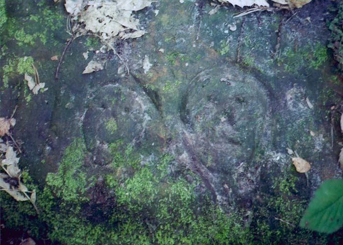
[visited circa 16/3/3] Unmarked on the main notice board & without an OS map of the area, these proved a tricky find. After coming down off the hillfort, walking through the village and failing to find the Cob Tree public house mentioned by Dyer, I asked a very helpful local. Luckily the first and easiest to find was 10 minutes walk up a path... I recommend parking in the Hillfort carpark and walking counter clockwise around the ramparts of the fort, until you reach the edge of public access. Then turn right and head off the fort, down some very muddy steps and the shelter is off to the left, past a fallen tree. Not that much to see but enough to see it would have been cold, wet and not that much of a shelter... By the side of the steps is a very curiously carved rock, from when I have no idea, anyone out there that can help?? Other shelters are accessible but I had run out of time. If I recall correctly, turn around and head back up the steps. You'll meet an apple orchard on your right, head down the side of it till its end and then turn left, the other shelters are thereabouts (ps you will need to trespass to do this). |
 Posted by juamei
31st March 2003ce Edited 17th April 2003ce |