Coming to the broch by the farmroad is easiest as there is a kind of platform there. I think the short wall-sections are gardenification like that which 'lost' us Peerie Howe further along the track. From this side you see a large excavation on the side of the broch and a kind of grassy track up the side.
On top the interior is all hollowed out. Looking over to the left is a distinct rectangular hollow. If not simply a later excavation pit this looks a likely intramural feature, either a chamber or the beginning of a stair. At the seaward side are further excavation traces. Apart from the flat 'platform' trackside the rest of the mound drops away in front of you. At the other side is another track going down, narrower and sharper and steeper.
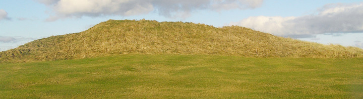
Along the Deerness Road, at a place where it narrows and there is sea on either side, you will find Dingieshowe. To reach Dingieshowe Bay itself means passing through huge grass-covered sand dunes. The one standing on your right is actually Dingieshowe Broch, with a cental depression but not much else to tell it apart. The beach has two distinct sections, the sands in front of you and on the left a gorgeous pebbly beach for the geologists amongst us (strictly speaking the Bay of Dingieshowe and the Bay of Taracliff).
The trows/trolls meet here on Midsummer's Eve - and over by Newark Bay about a-mile-and-a-half as the crow flies is Trowietown (not far from the burnt mounds etc. of HY50SE 2).
It has been asserted that there are further levels of the broch unexcavated but six foot is all that was found. This is not a greenfield site. Beneath the floor they found clay, vitrified sand and Neolithic potsherds (Grooved Ware and rough Rinyo-Clacton), and the Royal Commision found similar pottery in the kitchen midden [Grooved Ware has been found at Evie Sands by the Broch of Gurness]. Somewhere back on a hill south of the Toab road the descriptio of a tumulus, HY50NW 9, excavated by George Petrie in March 1850 (a 2m cutting from the east edge to the centre) gives us an idea of what likely preceded the broch. This conical barrow stood five feet high and thirty feet across inside a three foot wide shallow ditch. A ring of large burnt stones ran about the periphery of this clay mound. Halfway in the clay darkened and hardened. In the centre Petrie found a "considerable heap" of burnt bones and charcoal bits embedded in the clay in a three inch thick layer. He found no stones there and no tools in the barrow. Perhaps the five vanished Howies of Bossack (at the quarry that is now a tip) were similar. Petrie also dug one of the low flat-topped mounds a few feet away and found a NNE/SSW short cist containing earth and clay with some burnt bone at the bottom, with a celt deposited outside the NNE end. Could this be the nature of the presumed dwellings between Dingishow and the Deerness shore - they have been dismissed as the results of sand quarrying but the 1798 Statistical Account specifically refers to them as "hillocks of stones".
Dingieshowe (NMRS Number: HY50SW 7) was considered part of a bigger settlement at the end of the 18th century as they considered the stony hillocks beneath the present sand dunes between here and Deerness to have been buildings also.
First excavated in August 1860. It proved to be a broch standing six foot high with an external diameter of 57' and walls twelve foot thick that had been built directly onto a grass covered sandy hillock. Debris filled this Burg - potsherds, animal bones, a human skull, and between an edgeset slab and the wall a heap of water-worn stones like a celt workshop - and on the floor was a layer of red clay with an ash and charcoal deposit containing more animal bone. A mix of unburnt and burnt bones came from under parts of the wall. Beneath the floor evidence of a strong fire came in the form of clay and semi-vitrified sand, possibly cremation cramp.
Sometime in the 1920's an amateur excavation in the south side revealed a short length of simple drystone wall/walling and a small kitchen midden, from which latter in 1929 the Royal Commission retrieved hammerstones (Petrie's celts) and degraded potsherds. The O.S. in 1964 saw several small trenches and noted shell deposits on the mound's south and west slopes. Other shell middens can be found at the remains of Peerie Brough close by and near the cliff base close to the Sandaiken site in Taracliff Bay next door (just before you reach the seps up to the new trail). In 1986 the Royal Commission paid another visit, finding a possible bank and ditch at the north and north-west but noting that this could be the result of quarrying for sand.