The Modern Antiquarian
Log in
|
Register
Home
Latest Posts
Forums
Maps
Help
Browse Sites
News
Blog
Contributors
The Books
Select
-
Belgium
Denmark
Eire
France
Germany
Greece
Italy
The Netherlands
Norway
Portugal
Republic of Malta
Spain
Sweden
Switzerland
United Kingdom
County Limerick
Brufea
Standing Stone / Menhir
Brufea (Standing Stone / Menhir) on The Modern Antiquarian, the UK & Ireland's most popular megalithic community website. 2 images, 1 fieldnote, plus information on many more ancient sites nearby and across the UK & Ireland.
Image © Bawn79
Nearest Town:
Caherconlish (3km NE)
OS Ref (IE):
R654476 /
Sheet: 65
Latitude:
52° 34' 43.29" N
Longitude:
8° 30' 37.65" W
Added by
bawn79
Images (2)
Fieldnotes (1)
0 discussions
Start a topic
Show |
Hide
Web searches for Brufea
Flickr
Google
Google Images
The Megalithic Portal
Bing
Stone Pages
Wikipedia
Show map
(inline Google Map)
- Sites within 20 km -
-
Knockroe (0.14km NE) (2 posts)
Knockroe (0.28km NE) (2 posts)
Knockroe (0.45km ENE) (7 posts)
Ballybricken East (0.5km SSE) (3 posts)
Ballybricken East (0.54km SE) (4 posts)
Ballybricken East (0.71km SSE) (2 posts)
Inch (0.9km N) (5 posts)
Luddenmore (1km W) (3 posts)
Luddenmore (1km W) (5 posts)
Ballybricken West (1.14km SSW) (3 posts)
Inch St. Lawrence (1.3km NNE) (7 posts)
Stonepark (1.9km W) (2 posts)
Skahard (2.5km N) (3 posts)
Highpark (2.86km NNW) (3 posts)
Highpark (2.88km NNW) (4 posts)
Highpark (2.97km N) (1 post)
Highpark (3.02km N) (2 posts)
Ballingoola E (4.24km SSW) (1 post)
Ballingoola D (4.43km S) (0 posts)
Ballingoola (4.7km S) (1 post)
Ballingoola C (4.72km S) (1 post)
Ballingoola B (4.92km S) (1 post)
Ballingoola A (4.99km S) (2 posts)
Knockeen (5.15km ENE) (1 post)
Knockfennel (6.09km S) (3 posts)
Knockfennel North (6.15km S) (4 posts)
Knockroe (6.25km SSE) (3 posts)
Lough Gur O (6.35km S) (8 posts)
Lough Gur P (6.4km S) (1 post)
Entrance to Tir Na Og (6.45km S) (3 posts)
Knockfennel (6.59km S) (2 posts)
Knockfennel (6.61km SSW) (4 posts)
Lough Gur C (6.64km S) (17 posts)
Lough Gur D (6.64km S) (6 posts)
Grange / Lios, Lough Gur (6.74km S) (87 posts)
Lough Gur Wedge Tomb (6.74km S) (26 posts)
Moohane (6.76km SSE) (4 posts)
Carraig Aille (6.79km S) (4 posts)
Carraig Aille (6.79km S) (7 posts)
Rootiagh (6.85km SE) (3 posts)
Knockadoon (6.85km S) (1 post)
Old Hags Chair (6.88km S) (2 posts)
Knockadoon Circle K (6.98km S) (5 posts)
Friarstown (7.01km W) (6 posts)
Knockadoon Circles A + B (7.06km S) (1 post)
The Pillar Stone (7.08km SSW) (8 posts)
Rootiagh (7.14km ESE) (1 post)
Longstone (7.19km E) (2 posts)
Loughgur (7.19km SSE) (0 posts)
Bawnacouma (7.31km W) (1 post)
Grange Lios (7.42km SSW) (9 posts)
The Stone Of The Tree (7.49km SSW) (6 posts)
Black Sow’s Bed (7.93km S) (6 posts)
Rockbarton (8.48km SSW) (3 posts)
Cloghaunainey (9.76km SE) (1 post)
Ballynamona (9.96km SE) (4 posts)
Grillagh (10.03km S) (0 posts)
Knocsefin (10.05km E) (3 posts)
Cnoc Greine (10.21km E) (3 posts)
Castlefarm (10.87km SE) (4 posts)
Liseen (10.9km E) (3 posts)
Rathmore South (10.93km SW) (3 posts)
Knocksefin (11.14km E) (1 post)
Cnoc Aine (11.16km SSE) (2 posts)
Knockroe (11.29km ESE) (1 post)
Tuogh (11.29km ENE) (0 posts)
Cnoc Aine (11.3km SSE) (3 posts)
Cnoc Aine (11.3km SSE) (7 posts)
Cnoc Aine (11.32km SSE) (6 posts)
Lodge (11.36km SE) (4 posts)
Cnoc Aine (11.48km SSE) (1 post)
Doonglara (Glenbrohane) (11.5km NE) (1 post)
Cromwell Hill (11.52km ESE) (7 posts)
Bruff (11.99km S) (3 posts)
Hospital (12.79km SE) (2 posts)
Gorteennacreeagh (12.81km SE) (2 posts)
Tory Hill (12.97km WSW) (2 posts)
Coolalough (13.26km SE) (2 posts)
Tynacocka (13.44km S) (2 posts)
Gotoon (13.53km SE) (2 posts)
Garranbane (13.54km NE) (5 posts)
Rathanny (13.77km SE) (7 posts)
Coolalough (13.96km SE) (2 posts)
Coolalough (13.99km SE) (5 posts)
Sarsfields Rock (14.5km E) (3 posts)
Scraggeen (14.91km NE) (2 posts)
Knocktwo (15.13km SSW) (3 posts)
Cloonyconry More (16.23km ESE) (4 posts)
Ballinculloo (16.24km SSW) (4 posts)
Longstone (16.53km E) (3 posts)
Longstone (16.53km E) (1 post)
Longstone (16.53km E) (8 posts)
Bulgadenhall (16.6km S) (1 post)
Elton (16.94km SSE) (6 posts)
Ballinvana (17.32km SSE) (2 posts)
Ballinscaula (17.34km SSE) (6 posts)
Ballinscaula (17.34km SSE) (2 posts)
Glenbane (17.69km ESE) (1 post)
Adare Manor (18.11km WSW) (8 posts)
Kilmoylan Upper (18.16km ENE) (3 posts)
Clogher Hill (18.89km SE) (2 posts)
Lackanagoneeny (19.19km ENE) (4 posts)
Ballyard (19.27km NNE) (3 posts)
Ardataggle (19.48km NNW) (0 posts)
Clorhane (19.55km W) (4 posts)
Clorhane (19.55km W) (2 posts)
- Add -
-
Add news
Add an image
Add fieldnotes
Add folklore
Add miscellaneous
Add a link
-
Add a site
Add a nearby facility
Add an alternative name/spelling
Images
(click to view fullsize)
Add an image
Fieldnotes
Add fieldnotes
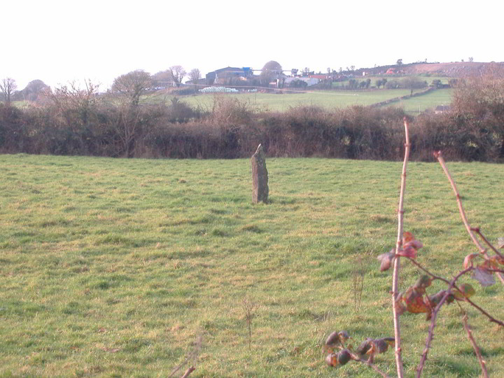
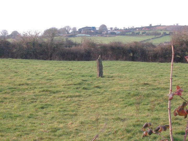
I didn't actually go into the field but took the picture from the road. This standing stone is in the shadow of the hillfort of Knockroe. I'd say its approximately 1.2m high. It is situated in a field alongside a farmhouse and out house buildings.
Comments (0)
|
Add a comment
|
Permalink
Posted by
bawn79
5th January 2006ce
Edited 5th January 2006ce