The Modern Antiquarian
Log in
|
Register
Home
Latest Posts
Forums
Maps
Help
Browse Sites
News
Blog
Contributors
The Books
Select
-
Belgium
Denmark
Eire
France
Germany
Greece
Italy
The Netherlands
Norway
Portugal
Republic of Malta
Spain
Sweden
Switzerland
United Kingdom
England
Northern England
Cumbria
Old Parks
Cup and Ring Marks / Rock Art
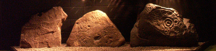
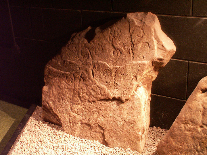
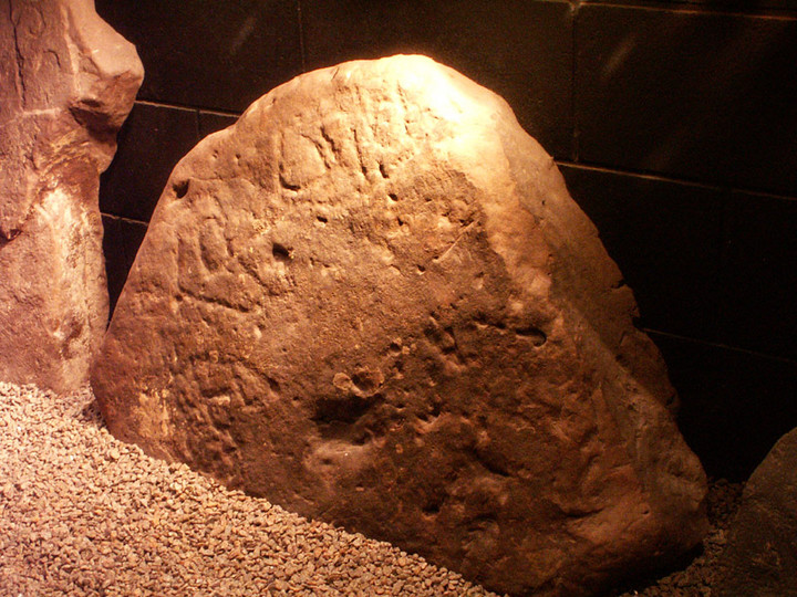
Old Parks (Cup and Ring Marks / Rock Art) on The Modern Antiquarian, the UK & Ireland's most popular megalithic community website. 3 images, plus information on many more ancient sites nearby and across the UK & Ireland.
Image © pebblewolf
Nearest Town:
Penrith (11km SSW)
OS Ref (GB):
NY570399 /
Sheets: 90, 91
Latitude:
54° 45' 7.18" N
Longitude:
2° 40' 5.38" W
Added by
rockartwolf
Images (3)
0 discussions
Start a topic
Show |
Hide
Web searches for Old Parks
Flickr
Google
Google Images
MAGIC
The Megalithic Portal
Bing
Stone Pages
Streetmap.co.uk
Wikipedia
Show map
(inline Google Map)
- Sites within 20 km -
-
Glassonby (0.63km SE) (32 posts)
Little Meg (2.47km SE) (65 posts)
Pond Enclosure and Brustop Wood (2.52km S) (2 posts)
Long Meg & Her Daughters (2.6km SSE) (254 posts)
Long Meg enclosure (2.81km SSE) (1 post)
Broomrigg (7.14km NW) (33 posts)
Stag Stones Farm (8.92km SSW) (2 posts)
Grey Yauds (9.13km NW) (11 posts)
Holme Head (9.25km SW) (15 posts)
Honeypot Stone (9.87km S) (5 posts)
Broad Mea Long Cairn (10.77km NE) (5 posts)
Winderwath (11km SE) (8 posts)
Green Hill (11.98km NE) (3 posts)
Brougham (12.3km S) (2 posts)
King Arthur's Round Table (12.37km SSW) (57 posts)
Little Round Table (12.55km SSW) (6 posts)
Mayburgh Henge (12.55km SSW) (117 posts)
Skirsgill Standing Stone (12.64km SSW) (11 posts)
Sewborrans (12.9km SW) (12 posts)
Mossthorn (12.92km SW) (4 posts)
Leacet Circle (13.6km S) (34 posts)
Hut (14.16km NE) (2 posts)
Bold Venture (14.23km NE) (2 posts)
Colouring Crags Long Cairn (14.29km NNE) (3 posts)
Clifton Standing Stones (14.51km SSW) (19 posts)
Slaggyford Stones (14.68km NE) (2 posts)
Alston Earthworks (15.87km ENE) (1 post)
Slaggyford Stone Rows (15.88km NE) (2 posts)
Low Moor (15.9km S) (21 posts)
Low Thornhope (15.94km NE) (12 posts)
Cold Fell (16.11km N) (6 posts)
Kirkhaugh (16.51km ENE) (6 posts)
Tortie 2 (17.97km N) (16 posts)
Tortie (17.98km N) (14 posts)
Skirsgill Hill (18.16km SSW) (1 post)
Dunmallard Hill (18.46km SW) (8 posts)
Motherby (destroyed?) (19.05km SW) (0 posts)
White Raise (19.16km SSW) (12 posts)
Maiden Way Standing Stone (19.17km NE) (1 post)
Moor Divock Centre (19.27km SSW) (8 posts)
Moor Divock Alignment (19.31km SSW) (5 posts)
Moor Divock SE (19.41km SSW) (24 posts)
Moor Divock (19.51km SSW) (8 posts)
Maiden Castle (Ullswater) (19.58km SW) (8 posts)
The Cop Stone (19.61km SSW) (26 posts)
The Cockpit (19.69km SSW) (52 posts)
- Facilities within 20 km -
-
The Village Bakery (Cafe: 5.1 km ESE)
Little Chef (Restaurant: 13.2 km SSW)
Queens Head Inn (Hotel: 14.8 km SSW)
The Sun Inn (Pub: 18.5 km SSW)
Parkfoot Campsite (Camping Site: 19 km SSW)
- Add -
-
Add news
Add an image
Add fieldnotes
Add folklore
Add miscellaneous
Add a link
-
Add a site
Add a nearby facility
Add an alternative name/spelling
Images
(click to view fullsize)
Add an image
 Image © pebblewolf