Showing 1-20 of 321 fieldnotes. Most recent first | Next 20 
This is a large boulder just on the edge of Billy's Dyke.
It has a number of possible cups plus natural cups and a large basin. I have have added it because it is mentioned in the book 'Rock Art and Ritual' by Smith and Walker.
There seems to be a little confusion with the name of this boulder, Smith and Walker state that it is known locally as the Cheddar Stone, the Magic Map has it marked as the Cheshire Stone.
Whatever the name it's a cracking spot to sit down, have a brew and take in the views.
|
Sadly this stone has suffered a little since I was here last. Some bright sparks have carved their names into the side of the boulder.
Rich mentioned that there may be a plan to site a stile over this stone. The sooner the better I reckon.
|
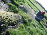
Whilst searching the Pinder Hawes Hill area of Skyreholme I came across a stone with a small, worn cup mark on it. I though little of it and mentioned it in passing to Greame.
On passing the stone Greame decided to lift the turf whilst making some throw-away remark that there was probably a pristine cup lurking below the turf...
Bugger me, he was right! Up came the turf to reveal a lovely large fresh-looking oval cup.
As far as we know, this is a new discovery the credit for which rests firmly with Greame C.
|
This ruined burial mound sits overlooking Malham Cove. Arthur Raistrick describes the mound as being 'three quarters removed at the time of the enclosures.'
There is still enough of the cairn remaining to identify the site so it's worth looking out for if you ever visit the cove. Access is fairly easy although you can't walk right up to the cairn. It can be viewed from the side of the cove once you climbed up the many dozens of steps and tottered across the lovely limestone pavement.
|
Arthur Raistrick described this site as a sub-rectangular Bronze Age house. Prior to his excavation the site was 'almost covered by scree on three sides'.
I had hoped that there may have been something left to see as Raistrick described the structure as being built of boulders.
On my visit I couldn't find a trace of the site
|
Seaty Hill
Not a lot to see on the ground, best viewed from the hill opposite, Abbot Hills, where the ditch and bank are more obvious.
Easy access from the track from Malham Cove or better still the footpath from the wonderful Gordale Scar. Either way a high stile over the wall is involved.
|
I have seen Cat Cairn many times on my visits to Aberdeen. The cairn sits on a high point on Tullos Hill overlooking the Altens industrial estate. I have often looked down Crawpeel Road and noticed the cairn sitting atop the furze-covered hill but have never taken time to visit it because whenever I'm in the area it's work related and all I want to do is leave and head for home. Anyway, I was staying in Altens for a few days and had time to kill so decided to walk up to the cairn.
The hill is part of the Loriston Country Park and can be accessed from the car park on Hareness Road. Unfortunately you can't park in the car park as the area was recently occupied by travellers. The travellers were evicted and then prevented from returning by blocking the entrance with huge boulders, however, parking alongside the road is not a problem unless you are driving a white transit van and towing a caravan.
It takes five to ten minutes to walk from the road to the cairn. The cairn is pretty much what you'd expect, a large round cairn of stones, If you look at the amount of stones in the field walls that lead up to and from the cairn it's easy to imagine this cairn being two or three times as large, with stones being robbed for walling. Another thing about the walls is that they use this and the nearby Baron's Cairn as boundaries, whether this reflects prehistoric boundaries is a matter for debate. It could also be argued that the walls start and terminate at the cairns because they were a good source of materials for the walls. Who knows?
What I really want to say about the cairn concerns the views and it is something that you can't really appreciate unless you visit the site. The view here is spectacular, this small hilltop commands views across the sea, the coast, the Dee river mouth, the city of Aberdeen, the hills beyond the city and on a clear day I would imagine you could get a glimpse of the Cairngorms from this point. It is probably the perfect location for a monument and if you are in area I would definitely recommend a visit.
At this point I was going to wax lyrically about a Bronze Age monument overlooking the Oil Age city but that all sounded a bit cheesy so I won't bother.
|
I visited the Nine Stanes after the two Esslie circles, parked-up at the forest car park and followed the short path to the stones.
This is a beautiful ruin of a circle, the forest, moss hung trees and lichen covered stones all blend together to produce a completely different sensory experience from the neighbouring Esslie rings. If it wasn't for the regimented lines of the forestry plantation you could easily daydream yourself back into prehistory at this lovely circle.
I noticed Hamish's outlier and its alignment with the recumbent stone and quite agree with him.
Nine Stanes is a lovely accessible site, one of the many jewels to be found in this part of the world.
|
I'd started off planning a visit to the circles around Old Bourtreebush but a wrong turn at Portlethen sent me heading forever westward along narrow lanes through the soft Aberdeenshire countryside. I revised my plan and decided to head towards the River Dee and the town of Banchory. After half an hour of being completely lost, not a completely new sensation, I found myself besides the river and heading the right way.
On the road to Esslie I passed a house called Standingstones, I parked up and took a look around but found nothing.
My next stop was at Esslie the Lesser. There were a few cows in the field so I decided content myself with the view from the verge. The stones of Esslie the Greater were just along the road and I could see that the field was clear so I headed off down the lane.
At Esslie the Greater the field gate was just tied with some band so entry wasn't a problem. The site is a fairly jumbled affair but the main components of the circle and ring cairn are present. The setting, in common with many other RSCs, is one of rich, rolling Aberdeenshire farmland and higher hills in the distance. Esslie the Lesser is visible from the circle across the shallow valley. It led me to wondering why create three circles, the two Esslies and Nine Stanes, within such a small geographical area? No answers came to mind apart from the fact that the locals must have really loved their stones to expend so much effort into building these beautiful rings.
All in all this is a lovely accessible site; it's a little damp underfoot but well worth a visit.
|
13th May 2006
The last time I was here the temples they were still being repaired after they were horrifically damaged by hunters at Easter 2001. The temples were fenced in locked up and no amount of pleading could get me through the gates. I had to satisfy myself with a mooch around the perimeter and a prolonged sit on the hillside behind the monuments.
As I walked up to the gated perimeter fence that separates the Hagar Qim temples from the path to Mnajdra I noticed some men working, as I got close to them I could see that they were putting razor wire onto the top of the already substantial fence. The temples have survived the ravages of time, environmental collapse and a couple of thousand years of conquest and invasion. It's extremely saddening that these unique structures, have to be protected against the all too real threat of vandalism by local people. I won't let this dishearten me, today is my temple day.
On the hillside between Hagar Qim and Mnajdra are a series of deep cavities that have been carved into the rock which are known as the Misqa Tanks It is thought that they were used as water cisterns for the prehistoric community in this area. It is possible to walk up to the tanks but today, despite having plenty of time, I declined not to do so. Today was not not a day for traipsing, I had to remain true to my purpose, Mnajdra is where I want to be.
Mnajdra is a difficult site to get your head around. It is actually three temples facing into a common oval forecourt. The smallest and oldest temple is to your right as you approach the site. It is described as a simple trefoil of the Ggantija phase. The second and third temples are of the four apse form and that's about as technical as I'll get.
I sat down and let the pure, deep joy of this place wash over me. The temples are nestled into a hollow in the hillside when you look uphill you see an endless blue sky, when you look downhill you see an expanse of deep blue sea. If you walk from the sea to the sky you will find the temples tucked into their niche somewhere in the middle.
Each temple is a different experience but it is all held together by the land and seascape. The temples, the hillside, the sea, it's just all too perfect. If you ever fortunate enough to visit Mnajdra, I would strongly urge you to go there as early in the morning as possible and try to experience the place without the distraction of strangers.
I'm afraid I'm not eloquent enough to elaborate on the feelings and emotions that this place provokes. Mnajdra is one of the few places on earth that really reaches down inside of me.
http://www.themodernantiquarian.com/post/46149/templehead_pt2_mnajdra.html
|
On a sunny, frosty winters morning and with half a day free I decided to have a mooch around a part of Westerdale Moor known as Crown End. If you look at a map of the North York moors you'll see that Westerdale Moor covers a fair swath, running from Farndale to the Esk valley. Crown End is only a small spur of the moor bounded by Baysdale and the Hob Hole Beck to the north and Westerdale and the infant River Esk to the south. The spur runs roughly west to east and is about a kilometre and a half long by about eight hundred metres wide.
The prehistoric remains on this section of the moor have been known about for the past couple of hundred years and were written about at some length by Frank Elgee. Essentially what you have is a cross ridge dyke running across the narrowest section of the spur, beyond that is a cairnfield and a possible enclosed settlement. The cross ridge dyke and cairnfield have been interpreted as Bronze Age and the settlement as Iron Age.
I parked up at Hob Hole, a local beauty spot popular with picnickers in the summer and generally deserted in the winter. It is also possible to access the moor by walking a mile or so from Castleton making this area accessible by bus or train.
If you use the Hob Hole car park you will need to cross over the beck using the ford, on my last visit there was a foot of water running over the ford so this wasn't an option and I parked at the south side of the ford.
Once on the moor, the first monument you'll encounter is the cross ridge dyke. This is a line of standing stones built into an embankment running north to south across the narrowest section of the spur. The southern section only contains a couple of decent sized stones; the northern section is more complete with a dozen or more stones remaining. It's quite surprising that anything remains at all when you look at the grouse butts and other structures on the moor. It makes you wonder what this monument would have looked like prior to the introduction of grouse shooting.
The northern section of the dyke terminates just before the land begins to drop off into the valley of the Hob Hole Beck, the final large stone has a cross carved into it. This cross may well indicate that this stone, or possibly the whole monument, was used as a boundary marker beyond the prehistoric period. Marked stones such as this one are often mentioned in the perambulations of the moorland estates. There is a cross marked stone in another, nearby cross ridge dyke, the Bridestones.
When I arrived at the stones the low winter sun was shining and everything was frosty and beautiful, however within half an hour the sun had disappeared and a dense fog enveloped the moor, you could almost hear the vegetation 'crisping up' in the freezing fog. The whole atmosphere of the moor was almost instantly transformed. Later, following a circular walk around the moor I returned to the dyke, as I approached I could see the stones emerging out of the fog like sentinels, perhaps this is how they were meant to be seen. It also made me think of nearby Hob Hole and its legendary inhabitants, perhaps these stones and the nearby ruined settlement gave rise to the lore of the Hobs or perhaps the legends started in prehistory when the Iron Age farmers founded their settlement Iron Age beside the Bronze Age remains.
Once beyond the stones you'll notice a number of low cairns and once past these you'll encounter a number of low rubble walls running through the heather. These can be quite subtle features but once you 'get your eye in' you'll notice them everywhere.
There's not a great deal else to say about this part of the moors. Crown End is a good place to visit as it offers plenty to see in a small area, it is also very accessible if you are using public transport and don't mind a walk. Access on the moor itself may be difficult for anyone with restricted mobility as the paths are uneven, narrow and rocky in places, access from both Hob Hole and the Esk valley involves a short steep climb.
|
I was back up at the Beeld today and have a couple more observations to add to my original fieldnotes.
Temple Beeld Hill hardly lives up to its title however, it is slightly higher that the surrounding area and is surrounded by bogs to the west, north and east. The land to the south is very wet, the Beeld effectively forms an island, a dry refuge for the few hardy sheep that roam this part of the moor.
That said, the 'hill' is within a basin therefore the views, though extensive across the flat moors to the west and east, are limited as compared to the view from the nearby rising ground to the south of the Beeld.
Unusually for an area so rich in prehistoric remains, this site does not appear to share intervisibility with any of the nearby monuments. I was unable to spot any of the local barrows from the Beeld.
Regarding the possible cup marks on the central stone, I'd say almost definitely natural weathering processes at work here as opposed to the hand of man.
Orientation of the stones;
340-160 degrees.
60-240 degrees.
The GPS stuff is
NZ 75725 10141 (accuracy 5m)
Elevation 214m
|
From Lacra C the terrier and I headed across the fields in search of the elusive avenues. After crossing some boggy low ground we came across a group of stones that more or less fitted Burls description of 'a few footballish boulders'. The eye of faith is definitely required here but given enough to-ing and fro-ing it is possible to make out an avenue. Saying that, if Mr Burl had said that they were just a fortuitous arrangement of boulders I would also agree with him.
I'm not too sure what to say about this site other than have a look for yourself and see what you think.This post appears as part of the blog post " The swift terriers bovine blues" |
From Lacra B the terrier and I walked west for a 100 or so metres to Lacra C. In the past these three stones have been interpreted as the ruins of a stone circle. Aubrey Burl is of the opinion that this is a fallen three, possibly four, stone row, which when you see the stones makes a lot more sense and besides that if anyone knows the difference between a circle and a row it's Mr Burl.
The stones themselves are quite low but of a decent size, they are aligned roughly north east-south west and are graded in size, the largest being the most northerly.
The largest stone also makes a handy seat to once again sit down and admire the views.This post appears as part of the blog post " The swift terriers bovine blues" |
From the village I followed the footpath that crosses the railway and then follows a sunken trackway uphill. As I walked up through the rough pastures I was aware of Black Combe, this hill is huge but in my opinion its presence is almost benign. This massive, soft, whale-back of a hill has to compete with two other even larger presences, the sea in front of it and the central fells behind it. Never the less Black Combe looked marvellous and reminded me of Benarty in Fife, part of the landscape but not domineering.
What drew my eye from the hill was the gentle curve of the coast, the estuaries and of course, the sea. As I reached the top of the hill I was able to look along the coast over Millom, the Duddon estuary, Barrow, Walney Island, and across Morecambe Bay into Lancashire and on to North Wales, and as my eyes got used to the haze I was able to make out the faint profile of the Isle of Man on the horizon.
Once at the top of the hill the terrier and I made our way over to Lacra B. We found the circle quite easily. The circle is sat in knoll on the hillside, all around the circle are large outcrops of bedrock jutting out through the turf at forty five degrees almost as if they are defending the stone ring.
The circle is composed of low stones and has definitely seen better days. The largest stone is just over a metre tall. It's possible to make out the slight rise of the central cairn but the thing that gives this circle its charm is the views, again it's the Duddon estuary, the coast and the coastal plain that draw the eye with Black Combe still visible over the brow of the hill.
I sat down in the circle and thought about how the land was used in the past, the estuaries and coast would have been an attractive place to live, Early man would have found this a rich place to forage and hunt. Wildfowl, shellfish, fish and animals would have lived here in abundance. Later, the pastoralists and farmers would have found the fertile Cumbrian plain ideal for raising stock; the surrounding hills would have provided summer pastures, much as they do today. The fertile soils of the coastal plain would also be an ideal place to plant and raise crops, the rivers running off the hills would have ensured an abundance of clean, fresh water, the wooded slopes providing an almost endless supply of timber for building and fuel.
The coast would have also provided the opportunity for contact with others. Archaeological evidence shows us that people have been navigating these coasts since at least the Neolithic, this part of Cumbria would have been an ideal stopping-off point for those early navigators steering a course to and from Wales, the Isle of Man, Southern Scotland or Ireland and they may well have used Black Combe as a guide.This post appears as part of the blog post " The swift terriers bovine blues" |
I walked here from Boat Howe following the ridge down from the Howe to Bulatt Bridge and then taking the left hand path towards Wasdale Head.
To find the cairn, once you have passed some broken down enclosure walls keep following the path up a sharp incline walk on a few more yards and then head east towards Hard Rigg, you should be able to see the cairn after a few yards.
The cairn sits on a col between Wasdale and Eskdale moor and as such may mark some form of territorial boundary, a liminal space. The setting couldn't be any better with the drama of the southern fells laid out before it.
The SMR states that this is a round cairn topped with a tumbled drystone wall of a circular sheepfold. It also states that local tradition has it that this was once a beacon, one of a chain between Millom and Cockermouth.
Whatever it was, it is now a very special place and is well worth a visit if only to sit within it's walls and watch the shadows of clouds move across the fells.
To return to the path, I would advise that you retrace your steps, the area south of the cairn is very marshy, as I found out to my cost. On the plus side, I picked a large bagful of wild thyme from this area and encountered a huge dragonfly.
|
Local photographer and regular TMP contributor, Nicola Didsbury told me about this site, she had been told that there was once a stone circle there which had been destroyed and all but two of its stones had been thrown into the River Eden.
See Nicolas notes here
http://www.megalithic.co.uk/article.php?sid=11486.
Access to the stones is via the approach road to Winderwath gardens. The entrance to Winderwath was until recently on the A66 however since the recently completed by-pass has been built you need to leave the A66 at the junction for Temple Sowerby.
There are two stones here; the first stone is a large upright block of porphyritic stone which stands beside the road. The second stone appears to be similar in composition and lays prostrate behind it, hidden by the fence and dense hedge. There are also a number of small stones which have the appearance of a field clearance.
I have been unable to find any reference in both the antiquarian and the modern literature to a stone circle or standing stones in this area; however this does not mean that this is not a genuine prehistoric site. Eleven kilometers to the west of this stone is the massive standing stone of Holme Head which was until recently unrecognized, which just goes to show that even in areas where extensive surveys have been performed it is still possible to find new sites.
|
I took the short walk here from Kirksanton.
This pair of beautiful stones on the edge of a stoney field appear to point to the Whicham valley and a possible route into the central fells via the Duddon valley and the Wrynose pass.
More importantly, they should also be seen as part of group of coastal monuments that include the nearby lost circles of Kirkstones, Hall Foss and Annaside. Beckensall in Prehistoric Rock Art of Cumbria quotes J. Ecclestone (1872) as reporting 'six stone circles, a Giants Grave, and a huge cairn south of the Esk.'
In his recent book Prehistoric Monuments of the Lake District, Tom Clare reports a buried landscape around these stones including what appears to be a ring of pits around the stones and other cropmarks which include 'timber henges or roughly circular palisaded enclosures with internal and concentric pits.'
I find it rather sad that these stones are all that's left of this once magnificent landscape, but then again at least they are still there and have not been destroyed, unlike many of our lowland prehistoric monuments.
Access is very good. It's possible to park at the field gate beside the level crossing and then it's just a short walk down a bumpy field margin footpath.This post appears as part of the blog post " The swift terriers bovine blues" |
This is a lovely little outcrop, in a small clearing and beside a small pool that looks like it is regularly used by deer.
The panel consists of 2 main motifs one roughly oval and one rectangular. There is a third, small motif which we were unable to locate
The panels were uncovered, cleaned and recorded.
I was particularly struck by the rectangular panel with it's concentric grooves. Rectangular panels enclosing cups are not a common motif in British rock art. However there are three such motifs, this one, Dod Law and Chatton all within a relatively small geographical area. Not sure what it all means but they are lovely things to see and feel.This post appears as part of the blog post " Amerside Law" |
This site is a lovely clearing in the forest. The site is raised and roughly circular and has signs of quarrying on its edges. To one side of the raised area is a substantial upright stone, judging from the fluting on the stone it has been stood upright for a long time. Upon lifting some of the turf I found a simple eroded cup and ring, on further investigation we also found another very weathered cup with a possible ring.
There was some debate as to whether these carvings represent the site recorded as Amerside Law 2.This post appears as part of the blog post " Amerside Law" |
Showing 1-20 of 321 fieldnotes. Most recent first | Next 20 |
https://teessidepsychogeography.wordpress.com/
|