Showing 1-5 of 15 posts. Most recent first | Next 5 
some notes from Skyreholme
Messrs Chappell, Stroud and I recently met up for one of our infrequent rock art forays into the Yorkshire countryside. I generally prefer solitary wanderings but never turn down a chance to walk with these two fine fellas, their depth of knowledge never fails to enlighten and the craic is always of the highest quality, modesty forbids me from detailing our discussion regarding proposed naming of new finds using the standard Bennettian nomenclature.
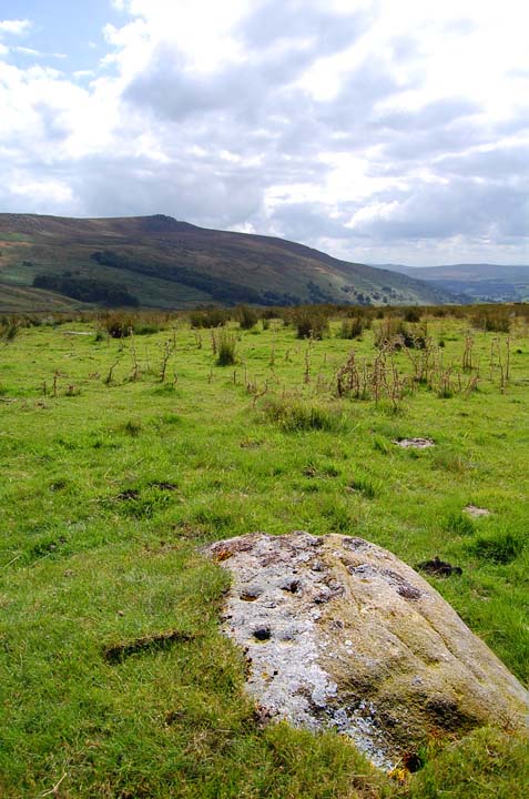
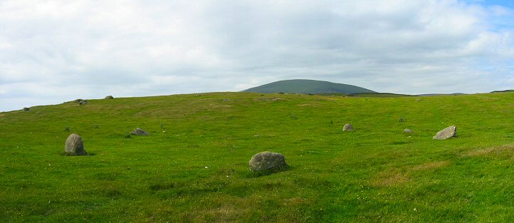
Our destination this time was Skyreholme. Individually we'd all visited this area, none of us had covered all of the ground and seen all of the carvings, we decided to put that to rights.
We parked up in the lay-by just by the junction of the Black Hill track and the B6265 and traipsed off across Black Hill.
The majority of the carvings are situated on or around Black Hill with another group running on east on either side of Forest Road track. The association of the carvings and the trackways may give some hint as to the antiquity of these routes.
For most of the southerly sites the views are across the Wharfe valley and the dominating presence is the craggy tops of Simon's Seat. This particular hill has prehistoric associations, a Bronze Age cairn known as the Devil's Apronful sits on its south west flank. On the southerly side of the hill are a number of named stones including a rocking stone and, although not prehistoric, the becks that drain the southern flank run down through the beautifully named Valley of Desolation where they join the River Wharfe just above Lud stream brow.
One observation that we made at a number of the carvings was the presence in the west of the distinctive, conical Elbolton Hill. The hill stands out quite clearly from the surrounding round topped hills.
This hill was definitely significant in prehistory, the Elbolton Cave has yielded early Neolithic to early Bronze age artifacts including flints, pottery, animal bones, 11 inhumation burials and 1 cremation burial.
The hill is clearly visible from the Appletreewick stone circle and may also be visible from other monuments further along the Wharfe valley such as Dumpit Hill and Yarnbury Henge. My gut feeling was that this hill may have some significance to the Skyreholme rock art sites.
Another potentially significant location in the local landscape is Trollers Gill, a limestone ravine, rich in folklore (see below), on the western edge of Black Hill. None of us had walked through the gill so we took the opportunity of dropping down along a steep, dry valley from Black Hill into its shady glades at the southern end of the gill.
During periods of high rainfall the gill is made inaccessible by the fast flowing beck that courses through the ravine. On our visit the beck was low and had disappeared underground through a pot hole at the head of the ravine and then reappeared at the bottom of the gill.
The southern end of the gill opens out into a very pleasant meadow hemmed in by limestone walls, however the whole place takes on an otherworldly atmosphere as you walk into the cool, damp, overhung mouth of the narrowing ravine. We all agreed that it was an extremely pleasant place to escape the heat on a dry summers day but would probably feel very different on a stormy winters evening.
Regarding the gills possible associations with the Rock Art. I can think of two other places where you get rock art and ravines, Roughting Linn in Northumberland and Fylingdales Moor in North Yorkshire. Ethnologically there are also similar associations in other parts of the world, one that springs to mind is the Rainbow Snake myths of Australia, I'm sure Graeme can provide many other examples from his vast knowledge of world rock art mythologies.
This from http://www.yorkshire-dales.com/trollers-gill.html
Troller's Gill is a sinister little ravine at the head of Trollerdale. Legend has it that this narrow limestone gorge is the haunt of the "Barquest" or "Barguest" - the terrifying spectral hound of Craven (which is said to have "eyes as big as saucers").
The nooks, caves and crannies of Troller's Gill are also said to be the home of Scandinavian trolls, evil bloodsucking gnomes, flesh-eating boggarts, hideous gargoyle-like rock sprites, deranged goblins, predatory pixies and maliciously twisted imps - and perhaps even other sorts of similarly diabolical and fiendishly unpleasant beings lying in wait for the unsuspecting rambler...
Near the head of the gill there are a series of disused mine workings as well as natural caves and potholes - including the ominously named "Hell Hole"
All in all, this part of the Yorkshire Dales area is rich in pre and post historic sites, folklore, caves, and wonderful upland landscapes.
Tourists are fairly scarce in this area so once you leave the roads you can usually wander wherever you please.
|
The swift terriers bovine blues
I'm a great lover of the British weather, rain, hail, wind, sun, snow I love them all. The only weather that I dislike is offshore fog. All offshore workers dread waking up to the mournful wail of the foghorn as it means only one thing, you're not going home.
So there I was, fog-bound with a camping trip to the Channel Islands planned. A trip I I'd looked forward to for the past few months. I'd researched the archaeology of the islands, compiled notes, I'd even bought some new lightweight camping kit.
But, there was nothing for it, stuck offshore, I had to cancel the trip, Bummer!
I needed a new destination for when I did finally manage to get home and as on previous occasions my attention turned to Cumbria. Cumbria holds a deep fascination for me. A few years ago I decided that rather than attempt to see all the sites, I would concentrate on distinct areas and then by visiting and re-visiting the area I would hopefully I would begin to gain some understanding as to why the monuments were located where they were and how they relate to each other.
Most of my wandering have been around the eastern margins of Cumbria however I have recently been making the odd forays onto the coastal plain. I decided this time I would continue with this by visiting the south west and have a look at Lacra and Burnmoor, two upland sites with multiple monuments and possible coastal associations.
The journey over the Pennines to Cumbria was lightened by the sight of green- canvassed horse drawn Gypsy caravans retuning home from the Appleby Horse Fair. The caravans were invariably driven by bare-chested blokes, walking their wagons up the inclines to spare the horses. It was a marked contrast watching the Gypsies taking their time, stopping and re-grouping in the lay-bys and road side cafes whilst the modern world hurtled by. It wasn't all picture book gypsies though, there were also plenty of chrome trimmed show caravans towed by ford transits or ugly 4x4' pick-ups hurtling along the dual carriageway with trotting carts strapped onto their backs.
I pulled off the A66 at Kirby Stephen and made my way through the Pennine foothills and Howgill Fells to the M6 and then into Southern Cumbria with occasional glimpses of the Irish Sea opening up in front of me. A journey from coast to coast never fails to thrill me, two seas in one day. I eventually arrived at Kirksanton, parked-up and set off on foot for the Giants Graves.
I took the short walk here from Kirksanton.
This pair of beautiful stones on the edge of a stoney field appear to point to the Whicham valley and a possible route into the central fells via the Duddon valley and the Wrynose pass.
More importantly, they should also be seen as part of group of coastal monuments that include the nearby lost circles of Kirkstones, Hall Foss and Annaside. Beckensall in Prehistoric Rock Art of Cumbria quotes J. Ecclestone (1872) as reporting 'six stone circles, a Giants Grave, and a huge cairn south of the Esk.'
In his recent book Prehistoric Monuments of the Lake District, Tom Clare reports a buried landscape around these stones including what appears to be a ring of pits around the stones and other cropmarks which include 'timber henges or roughly circular palisaded enclosures with internal and concentric pits.'
I find it rather sad that these stones are all that's left of this once magnificent landscape, but then again at least they are still there and have not been destroyed, unlike many of our lowland prehistoric monuments.
Access is very good. It's possible to park at the field gate beside the level crossing and then it's just a short walk down a bumpy field margin footpath.
  |
After visiting the Giants Graves I back-tracked into Kirksanton and headed up to Lacra.
From the village I followed the footpath that crosses the railway and then follows a sunken trackway uphill. As I walked up through the rough pastures I was aware of Black Combe, this hill is huge but in my opinion its presence is almost benign. This massive, soft, whale-back of a hill has to compete with two other even larger presences, the sea in front of it and the central fells behind it. Never the less Black Combe looked marvellous and reminded me of Benarty in Fife, part of the landscape but not domineering.
What drew my eye from the hill was the gentle curve of the coast, the estuaries and of course, the sea. As I reached the top of the hill I was able to look along the coast over Millom, the Duddon estuary, Barrow, Walney Island, and across Morecambe Bay into Lancashire and on to North Wales, and as my eyes got used to the haze I was able to make out the faint profile of the Isle of Man on the horizon.
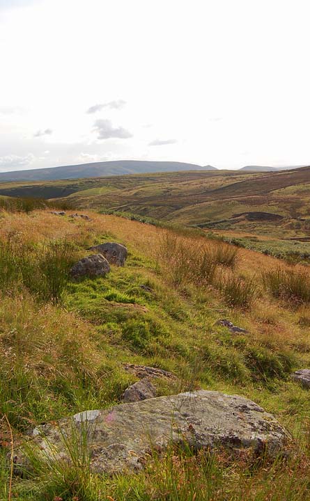
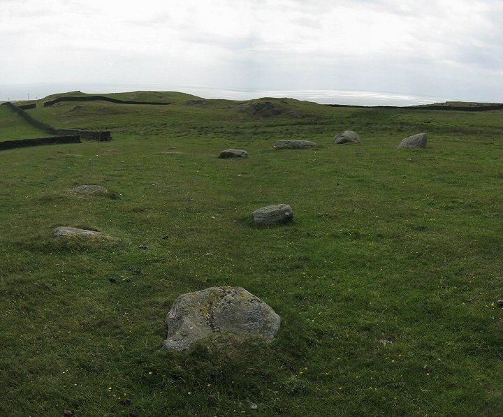
Once at the top of the hill the terrier and I made our way over to Lacra B. We found the circle quite easily. The circle is sat in knoll on the hillside, all around the circle are large outcrops of bedrock jutting out through the turf at forty five degrees almost as if they are defending the stone ring.
The circle is composed of low stones and has definitely seen better days. The largest stone is just over a metre tall. It's possible to make out the slight rise of the central cairn but the thing that gives this circle its charm is the views, again it's the Duddon estuary, the coast and the coastal plain that draw the eye with Black Combe still visible over the brow of the hill.
I sat down in the circle and thought about how the land was used in the past, the estuaries and coast would have been an attractive place to live, Early man would have found this a rich place to forage and hunt. Wildfowl, shellfish, fish and animals would have lived here in abundance. Later, the pastoralists and farmers would have found the fertile Cumbrian plain ideal for raising stock; the surrounding hills would have provided summer pastures, much as they do today. The fertile soils of the coastal plain would also be an ideal place to plant and raise crops, the rivers running off the hills would have ensured an abundance of clean, fresh water, the wooded slopes providing an almost endless supply of timber for building and fuel.
The coast would have also provided the opportunity for contact with others. Archaeological evidence shows us that people have been navigating these coasts since at least the Neolithic, this part of Cumbria would have been an ideal stopping-off point for those early navigators steering a course to and from Wales, the Isle of Man, Southern Scotland or Ireland and they may well have used Black Combe as a guide.
 |
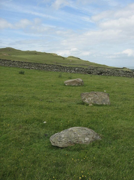
From Lacra B the terrier and I walked west for a 100 or so metres to Lacra C. In the past these three stones have been interpreted as the ruins of a stone circle. Aubrey Burl is of the opinion that this is a fallen three, possibly four, stone row, which when you see the stones makes a lot more sense and besides that if anyone knows the difference between a circle and a row it's Mr Burl.
The stones themselves are quite low but of a decent size, they are aligned roughly north east-south west and are graded in size, the largest being the most northerly.
The largest stone also makes a handy seat to once again sit down and admire the views.
 |
From Lacra C the terrier and I headed across the fields in search of the elusive avenues. After crossing some boggy low ground we came across a group of stones that more or less fitted Burls description of 'a few footballish boulders'. The eye of faith is definitely required here but given enough to-ing and fro-ing it is possible to make out an avenue. Saying that, if Mr Burl had said that they were just a fortuitous arrangement of boulders I would also agree with him.
I'm not too sure what to say about this site other than have a look for yourself and see what you think.
After puzzling with the avenues of Lacra C the dog and I headed up towards the ruined farm house and Lacra D, as we walked up a small rise a very large cow appeared at the top and started bellowing at us for all she was worth, we stopped dead and the cow was soon joined by another, equally as large and equally as aggressive. This was a little worrying, the cows were trying to tell us something and it definitely wasn't good news. In no time at all I picked up the terrier, stuck him under my arm, turned tail and ran. After a couple of minutes running I thought to myself, hang-on, I'm carrying a dog who could outrun me over any distance , so I dropped the dog on the deck and we both ran for the cover of the nearest wall. Once we reached the field entrance we stopped and looked back, the cows were still standing their ground, watching our every move. I decided that due to the fact that none of these fields had gates and those angry cows probably had calves, the best thing we could do was leave. So that's what we did, taking a leisurely stroll back down to Kirksanton.
I must admit, I was a little disappointed not to see Lacra D but there would be other days to complete our tour of what Burl describes as a meglithic 'melange'.
For future visitors. The path from Kirksanton is fairly steep and uneven so may not be suitable for everyone. For those who do make it up there, the megalithic remains are not very spectacular but are unusual and varied enough to justify the walk. The real rewards for getting yourself up to Lacra are the settings, the views are wonderful and are probably a huge reason why the sites are located where they are.
|
Amerside Law
For a while now the missing rock art panels of Amerside Law have been a nagging away at a few members of the rock art community. A few folk have tried to search for the panels but have been put off by,
A. The difficulty in gaining permission to access the land.
B. The dense forestry that covers the hill
Fortunately for us we have Rich. Rich has the gift of the gab and is well enough connected to overcome any access difficulties, problem A sorted. Marry Rich's talents to the terrier like tenacity of Hob and Andy and item B also becomes no problem at all. So a couple of weeks ago Hob, Andy, Rich and I had planned to head up to Northumberland to search for the missing carvings.
The day before the trip the weather forecast was giving out high winds and rain for Northumberland so we decided to postpone the 300 and odd mile round trip.
The next day Hob got in touch to say that he and Andy had decided to go up to Amerside anyway and had found two out of three of the missing panels.
This was great news, a wonderful rediscovery. The four of us decided to head up to the panels the following week to assist in further cleaning and recording of the carvings, Andy and Rich are members of the Northumbrian & Durham Rock Art Project so the formal recording of the panel was quite important.
The following Friday after a few hiccups we headed up to Amerside. We were joined by a trio of local rock art and archaeology experts. Our first task was to get to the panels. Our local friends had arranged for us to drive up the forestry track and get as near as possible to the plantation, this involved Rich driving up a steep dolomite track, risking life, limb but mainly Rich's engine sump. The drive up also took us past the famous Chillingham Wild Cattle, a breed of cattle that are "the sole survivors of herds that once roamed the forests of Britain." There can't be many ancient sites around the world that you approach in full view of a herd of unique and genuinely prehistoric animals.
Once at the plantation it hit home as to how difficult it had been for Hob and Andy to locate the missing panels. The panels had last been seen 25 years ago prior to the planting of thousands of tightly packed conifers. The only map reference they had was a rough OS grid reference. To give themselves a decent target area, Hob had employed a clever combination of google earth, various coordinate manipulations, a little bit of rock art suss and a minor hunting magic ritual. All of this led to Hob identifying a couple of possible small clearings in the trees that could be the locations of the outcropping carved rocks. When they finally located the first clearing, they found it to be three feet deep in woodland detritus. Most other folk would have walked away from this but not Hob and Andy who set to work digging out 25 years worth of dead branches and pine needles to reveal the outcrop beneath and thus rediscovering the Amerside carvings.
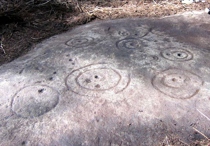
Amerside Law Panel 1
This panel is located in a small clearing within a densely packed conifer plantation. When Andy and Hob rediscovered this panel it was covered in a thick, dense mat of woodland crud which they spent a considerable amount of time clearing.
The panel is located on a rock outcrop; views from the panel are currently non-existent. If the plantation was removed, the main viewshed would be across the Till Valley to the distant Cheviot and surrounding hills.
The carvings themselves are much worn and were described by Stan Beckensall in the 1970's. It was not possible to locate all of the features included in Stan Beckensall's drawing of the panel. It appears that during the intervening years, a section of the carvings have disappeared completely, possibly due to damaged by forestry vehicles during the planting of the conifers.
Initially the carvings were quite difficult to make out, tracing their outlines with water helped bring the panel to life revealing a complex set of motifs. For me, one of the striking features of this and other panels is the asymmetrical nature of a number of the motifs. By this I mean that you have a large channel or double channel enclosing a number of cups, however, the cups are not evenly distributed but occur in one sector of the enclosed area or may even lay across the enclosing channel. This has always interested me, it is obviously a deliberate act and my personal opinion is that this strengthens the case for attaching a specific meaning to the motifs as opposed to purely an abstract design.
 |
After spending a good while at the panel we headed off in search of panel 2. Hob and Andy had been unable to locate these carvings but had discovered an unrecorded standing stone in the vicinity. To get to this area we had to walk along a wide track that had been cut through the forest, presumably to allow the heavy agri-industrial vehicles to access the forest and begin the harvesting of the timber.
This site is a lovely clearing in the forest. The site is raised and roughly circular and has signs of quarrying on its edges. To one side of the raised area is a substantial upright stone, judging from the fluting on the stone it has been stood upright for a long time. Upon lifting some of the turf I found a simple eroded cup and ring, on further investigation we also found another very weathered cup with a possible ring.
There was some debate as to whether these carvings represent the site recorded as Amerside Law 2.
From this site we then moved on through the plantation to the site of Amerside Law 3.
This site was also lost and rediscovered by Andy and Hob.
This is a lovely little outcrop, in a small clearing and beside a small pool that looks like it is regularly used by deer.
The panel consists of 2 main motifs one roughly oval and one rectangular. There is a third, small motif which we were unable to locate
The panels were uncovered, cleaned and recorded.
I was particularly struck by the rectangular panel with it's concentric grooves. Rectangular panels enclosing cups are not a common motif in British rock art. However there are three such motifs, this one, Dod Law and Chatton all within a relatively small geographical area. Not sure what it all means but they are lovely things to see and feel.
Leaving Amerside Law 3 we trudged back to the cars. After bidding farewell to our Northumbrian friends, Andy, Rich, Hob and I decided to take an early evening traipse up to the nearby Chatton carvings and then over to one of my favourite places anywhere, the wonderful beyond words Ketley Crag rockshelter.
The wind cut us to the bone on the walk up to Chatton but none of us cared, we knew what lay ahead. The ghostly carved panels of Chatton look marvellous at any time and were frame beautifully by the lovely evening glow of the slowly setting sun. From Chatton we walked onto Ketley and despite the cold and weariness of the day, I couldn't think of anywhere I'd rather be at that moment. A perfect end to a lovely day.
|
Templehead Pt.3 Tarxien - Right Place, Wrong Time
I left the Hagar Qim/Mnajdra heritage park with my head just about on overload. Tarxien was about 20 minutes drive away a drive that was to take me across the island and into the busy Maltese suburban sprawl.
When you look at a map you all the towns are neatly subdivided and labelled, no matter where you are in the world it is never like that. In Malta there is a huge sprawl centred around the Grand Harbour Basin. Tarxien is on the south side of this sprawl.
Once I actually found my way into Tarxien town I then had to negotiate a one way system which took me through a town that was never designed to handle motor traffic. Every now and then I would encounter a sign pointing to the temples sitting along side a no entry sign. But somehow the system worked and I found myself at the temples.

The contrasts between my morning visit to Hagar Qim and Mnajdra and Tarxien were marked. The Tarxien temples were in a very urban setting, there are no views here and the site is hemmed in on all sides.
At Hagar Qim and Mnajdra I was fortunate enough to have the place to myself, Tarxien was chocka block with people.
To be honest with you the place drained me. On any other day I would have been happy to walk around this wonderful temple and its wonderfully rich remains but on this day it felt all wrong. I had left a site which was wild and free and devoid of people, a site that was open to the elements and felt like part of the landscape. I had exchanged all of that for a site which was full of people and boxed into the middle of a sprawling dormitory town suburb. For me the atmosphere was one of claustrophobia.

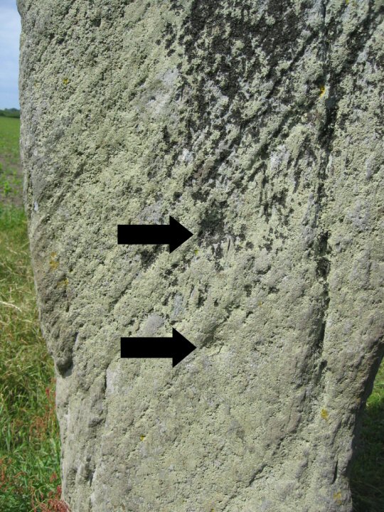
This doorway is a 60's reconstruction. The stones are original but had a protective coating applied to protect them from erosion


The site wasn't discovered until 1914 when farmers began hitting the blocks of the temple with their ploughs. The site was excavated by Sir Temi Zammit. There are four temples which were eventually forgotten and became overlain by a Bronze Age cemetery which in turn became buried and unnoticed for a few thousand years.

The site has yielded many of the wonderful artefacts that have since become icons of Maltese prehistory including the huge 'goddess' statue that was smashed by the farmer leaving only 'her' lovely chubby legs and carved base.
This site is also deeply instrumental in making sense of the chronology of maltese prehistory


The site is littered with carvings, most of which are replicas but like I said in my previous entry, don't let this put you off.

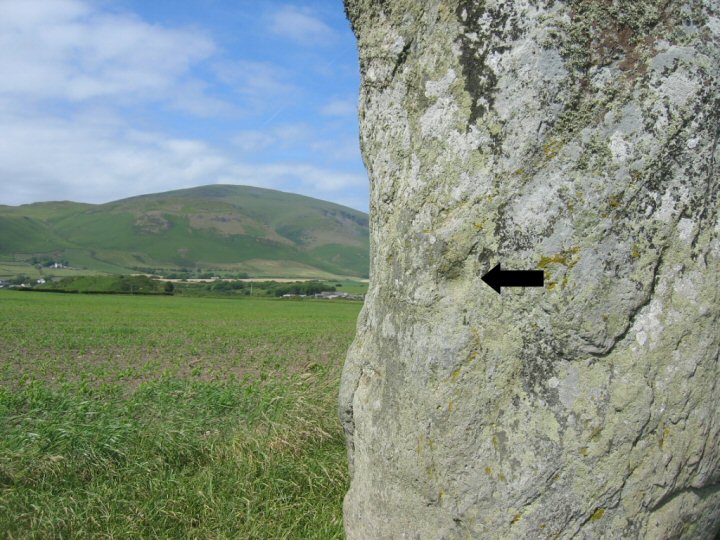
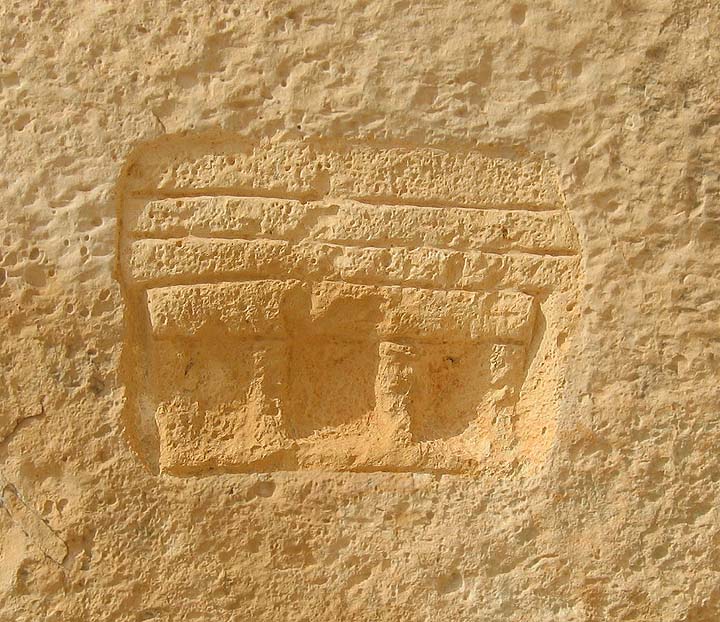
There is a copy of this decorated frieze at Tarxien. This is the original which is now housed in the museum in Valletta.

This carving shows a bull. The carving below it has been interpreted as a sow feeding her piglets.


The badly weathered carving in this picture is actually a replica. This shows the importance of removing the original carvings and placing them in a more environmentally controlled environment.
In hindsight going to Tarxien after visiting Hagar Qim and Mnajdra was a mistake. In fact visiting anywhere after visiting Hagar Qim and Mnajdra on the same day would be a mistake. I should have just lingered a little longer on the Hagar Qim café terrace, drank a little coffee and then made my way home. Hindsight is wonderful isn't it?
|
Templehead Pt.2 Mnajdra
Mnajdra
The last time I was here the temples they were still being repaired after they were horrifically damaged by hunters at Easter 2001. The temples were fenced in locked up and no amount of pleading could get me through the gates. I had to satisfy myself with a mooch around the perimeter and a prolonged sit on the hillside behind the monuments.
As I walked up to the gated perimeter fence that separates the Hagar Qim temples from the path to Mnajdra I noticed some men working, as I got close to them I could see that they were putting razor wire onto the top of the already substantial fence. The temples have survived the ravages of time, environmental collapse and a couple of thousand years of conquest and invasion. It's extremely saddening that these unique structures, the oldest stone built structures in the world, have to be protected against the all too real threat of vandalism by local people. I won't let this dishearten me, today is my temple day.
On the hillside between Hagar Qim and Mnajdra are a series of deep cavities that have been carved into the rock which are known as the Misqa Tanks It is thought that they were used as water cisterns for the prehistoric community in this area. It is possible to walk up to the tanks but today, despite having plenty of time, I declined not to do so. Today was not not a day for traipsing, I had to remain true to my purpose.
Hagar Qim is a spectacular site but Mnajdra is where I want to be.
Mnajdra is a difficult site to get your head around. It is actually three temples facing into a common oval forecourt.


The smallest and oldest temple is to your right as you approach the site. It is described as a simple trefoil of the Ggantija phase. The second and third temples are of the four apse form and that's about as technical as I'll get.
I sat down and let the pure, deep joy of this place wash over me. The temples are nestled into a hollow in the hillside when you look uphill you see an endless blue sky, when you look downhill you see an expanse of deep blue sea. If you walk from the sea to the sky you will find the temples tucked into their niche somewhere in the middle. Each temple is a different experience but it is all held together by the land and seascape. The Temples, the hillside, the sea, it's just all too perfect.

If you ever fortunate enough to visit Mnajdra, I would strongly urge you to go there as early in the morning as possible and try to experience the place without the distraction of strangers.
Mnajdra is one of the few places on earth that really reaches down inside of me. I'm afraid I'm not eloquent enough to elaborate on the feelings and emotions that this place provokes, so apart from adding a few comments to my photographs I'll leave it at.

The beautiful gnarly exterior. The naturally holed stones have their man-made counterparts within the temple.

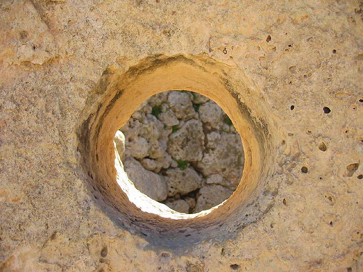
An oracle hole. There is a secret chamber behind this one.

Another oracle hole next to a 'portholed' side chamber


Altars

A libation pit. These pits are commonly found on the steps of temples and chambers throughout the islands.


Filfla is never far from view


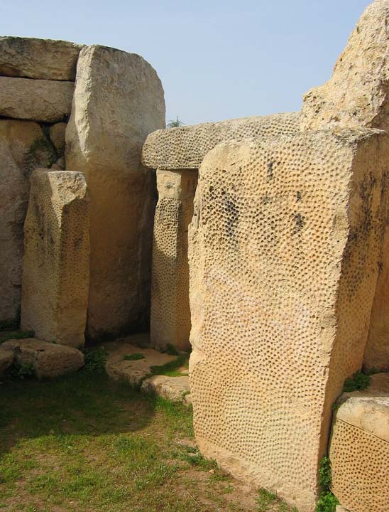
Lovely, lovely pitting

An inner apse

The Temple carving.
The location of the carving can be seen just beside the entrance on the picture above of the inner apse.

|
Showing 1-5 of 15 posts. Most recent first | Next 5 |
https://teessidepsychogeography.wordpress.com/
|