Showing 1-20 of 69 miscellaneous posts. Most recent first | Next 20 
|
The prehistoric rock carvings at Crap Carschenna, situated high above the unpronounceable village of Sils im Domleschg, were first discovered in 1965 during tree clearing prior to the construction of electricity pylons. For those able to read German, the definitive paper is that by Urs Schwegler: Felszeichnungen in Graubuenden; Helvetia Archaeologica, 1997, 111/112 pp 76-147.
|
I'm wondering if this account is speaking of the destruction of the same monument:
At Mayborough they dug up a brass celt. On the other side of the Eimot, upon a high ground overlooking all, is a very fine round tumulus, of a large size, and set about with a circle of stones: this in all probability was the funeral monument of the king that founded the temple and circus. Someone has lately been digging away part of the barrow, and carried off some of the stones, and demolished others. Later in the same text, Stukeley adds:The great barrow accompanied with stones, by the Eimot side, is called Haransley hill. Stukeley, Iter Boreal, 1725
|
In addition to the quote given by A.L. Lewis in Rhiannon's post below, the missing part of Stukeley's description can be found in his Iter. Boreal of 1725:-
On the south side of the town of Shap, six miles south of Penrith, we saw the beginning of a great Celtic Avenue, on a green common. This is just beyond the horrid and rocky fells, where a good country begins. This avenue is seventy foot broad, composed of very large stones, set at equal intervals: it seems to be closed at this end, which is on an eminence, and near a long flattish barrow, with stone works upon it: hence it proceeds northward to the town, which intercepts the continuation of it, and was the occasion of it's ruin; for many of the stones are put under the foundations of houses and walls, being pushed by machines they call a betty, or blown up with gunpowder. Though it's ourney be northward, yet it makes a very large curve, or an arc of a circle, as those at Abury, and passes over a brook too. A spring likewise arises in it, near the Greyhound inn. By the brook is a little round sacellum, composed of twelve stones, but lesser ones, set by one great stone belonging to the side of the avenue: the interval of the stones is thrity-five foot, half the breadth of the avenue: the stones, no doubt, did all stand upright, because three or four still do; but they were not much higher then, than now as fallen, because of their figure, which is thick and short: they are very large, and prodigiously hard, being nothing else but a congeries of crystals of very large sizes, of a flakey nature. Houses and fields lie across the track of this avenue, and some of the houses lie in the inclosure: it ascends the hill, crosses the common road to Penrith, and so goes into the corn-fields on the other side of the way westward, where some stones are left standing; one particularly remarkable, called Guggleby stone. The people say these were set up by enchantment: and the better sort of folks, as absurdly affirm, they are made by art. I doubt not but they are gathered somewhere off the surface, among the fells, and that there was a great temple of the old Britons, such as that at Abury, which it resembles very much, as far as I can judge at present; for the rainy weather, which in this country is almost perpetual, hindered me from making at this time a thorough disquisition into it.
|
|
There's a grainy, two tone image in a local guide to Columbkille that shows what really looks like a cup with a single ring and duct. The text implies it's a cross, but it really doesn't look like one. The slab is part of the roof of the souterrain which runs below the churchyard.
|
I can't help but wonder if the following description of a stone by John Hodgson might be somehow connected with Fitz's cup marked stone:
In passing over Moor-Duvvoch in 1800 I had observed a stone which I then supposed had some characters upon it with which I was unacquainted. In walking from Askham to Pooleybridge on 3 May, 1811, in company with the Rev. John Collinson, rector of Gateshead, and the late Mr. Matthew Atkinson, I was anxious to have a second sight of it, but sought it in vain...
...I did not, in this search, forget to look for the stone that attracted my attention in 1800, and reached it soon, when I found it to be a large detached mass of grauwacke, shewing its conglomerate origin in several rings and segments of circles eaten by the weather into its surface as sharply as if they had. been cut with a sculptor's chisel; and thus the long-encouraged vision of a Saxon or Latin inscription in Runic, or some other antique characters, vanished in a moment. This stone is upon the side of an old road or cast a little south of the south end of Lord Lonsdale's fir plantations on Moor-Duvvoch.
The Rev H seems to be describing inscribed circles. Bear in mind he was writing a decade before the first recognition of Cup and ring marks as ancient artifacts.
Maybe there is hidden Rock Art out there on Moor Divock.
|
As far as I can work out, the lost carvings of Amerside Law have not been seen in over 25 years. the grid ref given here is only accurate to 100m, and is not likely to be of a lot of use to those of us used to entering co-ords into a gps and walking straight up to a panel of rock art. Note that the plantation is private, so any attempts must be with landowner permission.
They were first shown to Stan Beckensall by a local shepherd who tended his flock on horseback (what an excellent way to find rock art, up high, wandering over bleak moorland in the low sun of winter...). Since then, the area has been very heavily planted with conifers and subsequent attempts to locate the carvings have been unsuccessful. Stan does point out that at least one of the forestry workers recognised the value of preserving the carvings, and that trees were not planted right up to the marked outcrop. the problem is, the rest of the trees are so closely spaced, that it's nigh on impossible to wander about looking.
However there are plans afoot to utilise new fangled technologies not previously available, to see if the dense shield of trees can be persuaded to relinquish the panel. We can but hope they are found before the trees are felled, as this might potentially damage the carvings (as no-one will know exactly where they are to avoid them)
|
From Camden's Brittannia, 2nd Ed."W. Matfen is the seat of sir William Blacket, bart. and in an adjoining field is a circular mount with a cavity at top, and by it a stone nine feet high, three feet by one and a half thick, called the Stob stone.
In opening of other tumuli of stones have been found two kistvaens, or coffins of four stones set on edge with a bottom and cover, containing the ashes of the dead appearing in a white dust. It has since all been removed" There's certainly no large mound next to the Matfen stone nowadays.
|
The grid ref given here is that matching the spot where in 1913, an oak coffin was discovered during ploughing. It's 1.67m in length and contained a few teeth, remains of stitched calf skin, a drinking cup and flint scraper. Radiocarbon dates of 2400-2200BC were determined, suggesting an early BA date for the burial.
the C&R stone does not seem to have been part of this burial, but it's exact findspot is unclear.
|
|
This collection of circles is now destroyed, the correct grid ref would have been SW36753306, but I've tweaked it slightly so that the pin appears in the right place on the inline map.
|
This mound features in Camden's Brittania as 'Dewley Lowe', where it is mentioned in association with the nearby Heddon Law burial mound:
There is yet remaining one very great heap of stones, besides other tumuli, and a remarkable one farther to the east called Dewley Lowe, with a smaller one near it. The reference to another mound is particularly interesting.
|
The county SMR describes this as:
"A tree-covered round barrow of earth and stones, 22.45 m in diam, 2.21 m high with what appears to be a surrounding ditch 0.20 m deep and bank, 1.10 m max. width and 0.20 m high"
A quick look at some satellite images shows that it's not tree covered, and that the bank and ditch are just visible.
|
According to Colin Richardson, this cup marked stone is thought to have once been upright, and accumulated cairn material about it's base afterwards. Presumably this material was removed during the excavation. Dating was inconclusive, though the usual late Neolithic/early bronze age period was assumed.
Excavations on a cup-&-ring marked boulder on Tortie Hill.
(Transactions of the Cumberland and Westmorland Antiquarian & Archaeological Society, 92, 1992, 7–11, ISSN 0309-7986):
|
Sat 2 - Sun 3 December 2006
Sat 9 - Sun 10 December 2006
As part of The North East Winter festival, artist Philip Supple has been commissioned to create an effects lighting installation piece focusing on the cup and ring marks at Lordenshaw. It has been described as 'Subtle, yet mind-blowing'.
The installation is to be an important feature of a series of guided walks from the nearby village of Rothbury, to the 'sacred hill' of Simonside, the walks highlight the archaeology of the area, and also include an emphasis on the folklore of the Duergar.
Contact Rothbury National Park Centre (Tel: 01669 620887)
or visit: the NE winter festival website .
|
From 'Notes On The Standing Stones of Kintyre', by Duncan Colville, 1929.
"North-east of Achadh-a'-Charra, at an equal distance from the Chapel, is Cnoc-a'-Charra, or 'the hill of the pillar.' On the top of this hill there is another stone 9 feet long, and 3 feet 10 inches in circumference; of the 9 feet, 2 feet are in the ground. Still farther to the north-east, on a higher hill, there was a cross which fell some years since, and was broken; the three stones were in a straight line."
This pillar on Cnoc-a'-Charra is now well known on account of the Ogam inscription incised upon it, and a most interesting description of it4 will be found in the first number of Scottish Gaelic Studies, published 1926. There we are told that in the course of last century it twice fell down, and on one of these occasions a length of about 2 feet broke off athe top, and is now lost. Consequently it now stands about 5 feet 9 inches above ground. Detailed particulars of these accidents will be found in Rhys's account of the stone in vol. xxxi. of the Journal of the
Royal Society of Antiquaries of Ireland, from information supplied by the parish minister, the Rev. John Francis Mackenzie. The damage was said to have been caused by some quarrying operations in the hillock, and that it suffered further rough treatment may be gathered from the remarks of another writer, who records that several times the pillar was pushed over by the lads of the neighbourhood, and subsequently replaced by the orders of the proprietor.
It may be of further interest to note that on 27th June 1899 this stone was inspected by a large party of members of the Royal Society of Antiquaries of Ireland, and of the Cambrian Archaeological Association, who visited the island in the course of a specially organised archaeological trip to the west of Scotland in a steamer chartered for the purpose. A description of this visit, illustrated by a photograph of the stone, was published in the Journal of the first-named Society
|
The western outcrop of Lyham Moor forms part of the eastern edge of the Till valley, being the stretch that connects Ketley Crag and The Bowden Doors. As such it has some rather good views of the Cheviot massif, as is in keeping with the placing of most rock art in the valley.
It has so far yielded 4 bits of rock art, the most complex of which (Lyham Moor 1) has been likened to the keyhole motifs on Stronarch Wood.
It's also worth noting that the well/spring near the carvings may have had significance in prehistory, as a bronze age sword was found there, with the assumption being that it was a votive offering.
All four panels are represented on the Beckensall Archive, the other three, rather prosaically named, are: Lyham Moor 2, Lyham Moor 3 and Lyham Moor 4
|
Courtesy of the nice people at RCAHMS:
Occupying the summit of Tom a' Chaisteil, a rocky spur, is a fort, sub-circular on plan, measuring c. 33.0m NNE-SSW by c. 31.0m, within a tumbled wall, most of which in the E has fallen over the cliffs of the spur. Occasional outer facing stones can be seen but no inner face, so that the thickness of the wall cannot be determined, although the width of tumble suggests that it may have been about 3.0m. The entrance was probably in the W where a gap has been blocked by a later wall, but no details survive. The interior is featureless. Some eight to ten metres to the N of the fort is a trench c. 2.0m wide and c. 0.6m deep, extending 35.0m W from the cliff. It is presumably associated with the fort, the most likely explanation being that it is part of an unfinished outer defence. On the W side, below the wall, is a recent shelter
I'd take issue with the comment about 'featureless' interior. I'm sure there were bits that looked like hut circles.
|
George Tate wrote in the late 19thC:
The other two camps are on the Horton grounds. Near to one of them are the remains of a stone circle, which during the last century would have been called a Druid's temple. Five stones are remaining, two only standing in their original position; when complete the circle had been about 100 feet in circumference; and it probably marks the burying place of some chieftain. At no great distance form it, are several barrows which also appear to have been places of sepulture. Mr Greenwell dug into some of them, but nothing was discovered save traces of burning. Which makes me wonder where the fifth stone went, and when was the third (temporarily) re-erected? Are the two standing today the same two Tate observed? What about the cairns and can they still be found amongst the heather?
|
According to Timothy Darvill & Blaze O'Connor, an early 20thC excavation showed up zoomorphic carvings on one of the stones from the mound.
The relevant abstract from the proceeedings of the prehistoric society can be found on University College London's website.
|
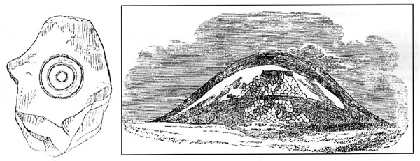
One of the many barrows at Came Wood yielded a rare (for the South of England) example of prehistoric rock art in the form of a cist cover with three concentric circles. It gets a mention in Tate's 'Sculptured rocks' book, a more detailed description being given by the excavator. (Warne, C. 1866. The Celtic Tumuli of Dorset. London: John Russell Smith.)
An image of the concentric circles can be found on the University College London web site.
Alas, this particular marked stone is currently on the missing list.
|
The remains of 2 Bronze Age cairns, the most northerly of which, when excavatated in 1885 by GR Hall, yielded several cists and 17 examples of portable rock art, including one example of the rare 'microcups'.
English Heritage's online record of scheduled monuments claims that these portables have since been lost. In fact, they are safe and warm in the stone room of the Newcastle University Museum of Antiquities. The confusion may have arisen as EH spell Pitland with two 't's, whereas everyone else seems to spell it with only one. But it's the same site.
These portables may also have been the subjects of the first ever photograph of prehistoric rock art. Possibly.
|
Showing 1-20 of 69 miscellaneous posts. Most recent first | Next 20 |
I like the Prehistoric Rock Art of Northumberland:
Ketley Crag
Chatton
Weetwood Moor
Dod Law
Roughting Linn
Lordenshaw
Fowberry Cairn
Hunterheugh
Old Bewick
Morwick
Currently obsessed with waving torches at things, often including rocks, as a prelude to some serious waving of torches at rocks that will inevitably appear here on tma at some point :)
|
