Showing 1-20 of 171 fieldnotes. Most recent first | Next 20 
Thursday 1/12/05
Well- what an improvement to this lonely site. Looks like the council have finally spent some money and tidied this place up as well as a new 'Wiches Stone' plaque on the freshly painted railings and a small plaque at ground level explaining a bit about the stone. All the ivy and vegetation that had almost engulfed the stone has gone to be replaced by a sympathetic rockery round the back and some white quartz around the stone. Great improvement, but this spot still gives me the creeps!
|
Thursday 1/12/05
Wow- looks like the council have really got their act together with this site too (see the improvements to the nearby Witches Stone). What a difference- for once you can actually walk down to the well house instead of trying to balance above it on an old stone wall then jump into a mass of nettles and brambles. Gone are all the head-high plants and the whole entrance to the well-house has been landscaped and planted. There are also some new stone steps leading down to the well itself. All in all a vast improvement to what was a very neglected but important holy well.
|
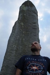
Friday 27/8/04
Absolute genius. The vision to place these stones atop this hill as a monolithic mirror image representation of the Eildon Hills is phenomenal. I am blown away by this (almost literally- it's a howling gale up here!). It's not until I visit the Cow Stone, just 320 m ENE and slightly downhill from here do I appreciate that these stones feel also like a gateway. I don't think that the Cow Stone should be seen as a completely separate monument as the three work so well together. I walk back up the hill from the Cow Stone to the Brothers Stones- and, in between these giants, the land to the West opens up and right in the middle- the Eildon Hills. I actually said 'WOW!'
The pair are aligned NNW/SSE. The northernmost stone is rectangular in section measuring 75 by 57 cm. The stone tapers to the top (2 m high) and the rectangular top is angled and slopes up from E to W in the direction of the Eildons- as does the southernmost stone. The S stone is triangular in section and measures 90 cm by 1 m by 1 m. It's a beast at 2.5 m high. One side is aligned perfectly N/S.
|
Friday 27/8/04
Only about 320 m down a slight hill from the Brothers' Stones is this massive irregular lump of a monolith. It's 2 m high by around the same in it's greatest width. One of the major axis is aligned NNE/SSW. There is a great notch at the top through which to view the Brothers' Stones. Taken with these pair, this monolith forms a huge triangle on Brotherstone Hill and the walk from here, back up to those pair is like passing through a megalithic gateway.
|
Friday 27/8/04
This site is marked on the 1:25000 OS map as 'standings stones', but there is definitely only the one here (as confirmed by the RCAHMS notes). It stands next to a dry stane dyke at the entrance to a ploughed field. It's aligned NW/SE and there is a very curious 'seat'-like shape to the stone- whether natural or sculptured it's difficult to say, but there's a seat part and the bulk of the stone forms the back part! The stone is 1.47 m high by 1.2 m wide and around 36 cm thick. The E side has the 'seat'- it's 42 cm wide and 1 m long. Nice spot for a sit down!
|
Friday 27/8/04
A kilometre SW from Bruntaburn standing stone is another- but this one is not marked on the 1:25000 OS map- dunno why- it's a big as Bruntaburn. Almost square in section the sides are aligned approximately NE/SW. It's 1.8 m high and about 1 m square. The W side has two holes drilled as it looks like it was used as a fence post sometime in the past. There is no note in the RC notes though of a series of four vertical holes/hollows on the E side. Making my way back to the road I meet with two women on horseback who stay here. They tell me about the other stones in the vicinity and note that they feel this place to be magickal- 'it's as if someone is watching you all the time you are out here'. It's true- this tiny lane and the country about it has a certain forgotten otherworldliness feel to it.
|
Friday 27/8/04
A great country road leads you to this stone- there are elaborate stone arches across the road in two places- one almost completely covered in ivy. As is this standing stone- especially the NE side. According to the notes from the RCAHMS I have with me this stone was not noted by RC surveyors in 1980. It may be partly ivy covered, but they couldn't have looked very far as it's about 2 m high and almost 1.5 m wide at base (and about 55 cm thick). It's aligned NE/SW and there's a natural cup mark on the top. The E face of the stone is almost flat, the W side is curved slightly.
|
Tuesday 24/8/04
Another steep and tricky cliff face- another site! It's a bit of a scramble up here over slippy grass, scree, through gorse and stinging nettle. I'm back up here with the digi cam to take some decent pics and also some measurements- especially of the 'hunter' figure. The deer was only rediscovered in 1996, but no mention was made of the human figure only 3 cm to the left of it. To be fair- the deer is very prominent compared to the human, but the latter is definitely pecked from the rock using the same technique as the deer. The deer is 145 mm long by 107 mm high. The horns are 47 and 45 mm long. The human 'hunter' figure (which is 21 mm to the left of the nose of the deer) is 17 mm wide by 68 mm high with legs 30 mm long. It appears to be holding a weapon of sorts on its left side- possibly a representation of a bow and arrow, this being 37 mm long.
Just about 1.1 m to the right of the carving there's a crevice in the cliff face and a crack forming a natural chimney- indeed the rocks in the crevice are blackened with carbon and soot. At the base of the rock with the carving is a horizontal slab approximately 80 cm by 1 m to sit perched on the cliff. I guess it's impossible to date such a carving, but this place has a very ancient feel to it- the deer and hunter carving, the fire shelter, the perch high up on a cliff…
|

18/7/02
On an extremely muggy and warm lunchtime I find myself on the stone perch next to the deer having lunch and admiring the fantastic view. I took the path round the base of the hill this time and straight up to here- very tricky as it's mostly slidy scree. Only stopped on my way up here to sample the very good wild raspberries growing all over the place. I was having a re-check of the carving- it's on an almost lozenge shaped rock about 75X32 cm forming part of a small cliff rising to about 2 m by about 1.5 m wide. The deer is pecked from the rock and in recognising this I notice something so obvious that I missed it on my last visit- just to the left there is what appears to be a humanoid figure- bloody hell! It's not as deeply carved as the deer though. I have a good survey of all the rock faces around the cliff- but no more carvings.
|
7/7/02
Not the easiest to find- the GPS was about 6 m off, but I found the tiny creature on a slab of red rock looking SW across the Braid Hills. I was expecting something Pictish, but this looks far, far more primitive. There's lichen growing in the actual carving so it's definitely not recent (not that it looks in any way modern).
|
Friday 20/8/04
Just a short walk from the rather good Harestanes visitors centre and just off the St. Cuthbert's Way path. A drive leads off from the country road up to Woodside house and the standing stone is apparently in the small wood on the left- we walk up the drive, but no sign, down again and I spot, just peaking out through the thick vegetation- the top of the monolith. It ain't gonna be easy getting to it though- the plant life is thick and nasty looking, but I think I see a line through it. Well- between me and the stone there's a small burn and the sides drop down into it- it's down there that the stinging nettles are over 6 foot tall and the brambles are around waist height. They are also old which means the thorns are thick and real sharp- it's slow going but I keep pressing on through it- my legs are ripped to shreds and stung to bits- mebbe a bad idea to attempt this in shorts! Eventually I am beside a thick and bulky stone. It's almost 90 cm square and not much higher at about 1.3 m.
After all that- turns out that there's an easier way to get here- through a gate off the drive and up through a field to the west of the stone- I return to the road this way…
|
Friday 6/8/04
I drive up a small forested road to Menzion. The pine trees line either side of the singletrack, but give way slightly as the road passes through three standing stones. I park up and walk back. Two of the three stones are on the N side of the road, one to the S. The most northerly stone is almost square in section, 1.1 m high by about 67 cm square with an almost flat top. The corners of the stone are aligned perfectly N/S pointing to the stone on the south side of the road. Approximately 17 m S to the next stone. This one is 1.3 m high and 1.5 m by 70 cm at the base. The whole stone tapers up to the sky and is aligned E/W pointing to the third stone. Approximately 15 m west to stone three. This stone is the smallest of the trio and leans slightly to the SE. It's 90 cm tall and 60 by 69 cm on plan. I put the compass and tape measure away, take some pics and then just look at this site and walk around the stones. There are blue skies above us now and sweltering heat. There are no sounds except from nature- flies, songbirds, crows and buzzards echoing through the forest. This is a very atmospheric site. Very remote, quiet and peaceful.
|
Friday 6/8/04
This cairn sits in the middle of this moor and scrubland with the tail end of the Pentland Hills to the east and Tinto to the southeast. A grassy mound rises from the moor to a height of approximately 1 m, but what makes this cairn particularly interesting is the short cist still in place in the middle of the mound. The cist is aligned NE/SW and is 1 m long by 33 cm wide by 58 cm deep. There are only four stones remaining- the cist is open at the SW end with no capstone either, but a large stone lies just to the east which may have been one of the uprights.
|
NT00644990
And only 200 metres from Wester Yardhouses cairn on a small hillock rising from the moor is this denuded cairn. A modern cairn has been built on top of the remains of the original cairn. Although this hillock is only 295 m high it still commands a great 360 degrees view from Tinto, Lanarkshire and the Pentlands. The cairn itself is about 20 m in diameter by around 1 m high (the modern cairn rises from this to a height of 1.2 m). On the S and E edge there are still some kerb stones in place- up to 75 cm to 1 m long by around 40 cm wide. Just 1 m N of the modern cairn there are two pits and also around the N edge many small stones protrude through the grass.
|
Friday 6/8/04
Approximately 130 m WSW of the Giants Stones there are two, now recumbent, stones lying behind a row of trees next to the road. The largest is lying NE/SW and is 2 m long by 1.1 m wide by about 40 cm thick. There is more moss and lichen growth on the NE end of this huge stones- was this originally the top? Just 10 cm away, but now completely covered in moss and grass (and I only found it after stubbing my boot on it!) is another large stones- this one is approximately 1.6 m square. Just 4 m to the S of this pair, another smaller stone lies- 95 cm by 87 cm by 20 cm. There is no mention of three stones in either the Royal Commission or OS reports from 1956 to 1972. Could there possibly have stood another trio of standing stones just S of the Giants Stones?
|
Friday 6/8/04
I almost couldn't find this obvious stone- there was a car parked next to the cattle grid where this stands and as it's only 86 cm high I just couldn't see it til the last minute before I was just about to get back in the car! This stone is now a boundary marker and marks the boundary between Selkirkshire and Peebleshire. As is the case with many boundary stones this was probably a re-used monolith. It's now aligned NE/SW and there is some carving on the W face-the only word I can make out is 'Tweed' (as in the river, not the cloth!).
|
Friday 6/8/04
I cross a field of sheep in the direction of a small forest built upon a hillock only 274 m high, but still offering a defensive position as much of the land around is flat and falls away to the W. I find a gate through the electric fence (thankfully!) and scrabble through dense undergrowth and many felled trees. Unfortunately the remains of this broch are just that- much destroyed. There are remains of a moss covered wall section at the NNE and four very large stones on the NW side, some as large as 1.5 m long. But this site is covered in long grass and has also been forested and then harvested without clearing, so it’s very difficult to get an overview of this site.
|
Friday 6/8/04
Driving way up a tiny country road (and I use the word ‘road’ in its loosest possible meaning- put it this way there’s grass growing up trhough the remains of the red tar in the middle of it!) I meet a friendly old man out for his walk in his wellies. I stop to ask him about the souterrain of Wester Yardhouses and if it is okay for me to visit and take some pictures, ‘aye, nae bother’! Turns out this guy is a font of local knowledge regarding antiquarian sites. He tells me about Scottish Water doing some work up on the hill next to one of the cairns and unearthing a massive stone but not really realising what they were doing! He also tells me of an old friend of his who stayed nearby, now long gone, who, every year, used to clean 13 old boundary stones that crossed the Pentlands. We make our separate ways and I head across to the corner of a lonely field of Lanarkshire. Under a dry stane syke, a hole. A muddy entrance 86 cm wide by 1 m high. However, this wouldn’t have been the original entrance as an unroofed section runs about 2.75 m EW before this. I put my hard hat and boiler suit on and crawl inside. The mud floor of the souterrain rises up for about 2.5 m and then falls away, but it has been deliberately blocked only about 4.5 metres from the present entrance. At the very end are a couple of piles of rabbit bones and skulls. There are still some massive lintels to be seen in the short passageway, one being about 1 m wide by 1.5 m long. I take some pictures, write these notes and head back to the car under a grey sky with nothing but the cry of buzzards overhead.
|
Monday 2/8/04
Three circular enclosures; A at NT17515363, B at NT17675365 and C at NT17745382. A measures 17 metres in diameter (and also has an internal circular stony mound), B 5.5 metres in diameter and C 8.5 metres in diameter. The site classed as B is 140 metres ENE of A and C is 180 metres NNE of B- all would have easily been intervisible with each other before the forest plantation.
Quiet and remote forest on Auchecorth Moss. Three rings of moss and grass rise from the earth, three sites of cremation and final rest. An early evening August sun beams down into the clearings and the forest rings with birdsong. The distant call of cattle. Butterflies, dragonflies and a myriad of insects fill the air. The sickly sweet smell of the heather moorland. Crows peck at the field behind me and distant hills just seen through the summer heat haze.
|
Monday 2/8/04
In a clearing in Deepsyke Forest just off the road stand an old 20th Century tower, the purpose of which I don’t know- there are also four strange looking pillars on the way along this road marking the fringes of the moorland. Just SW of the tower is the remains of this long cairn. It’s now reduced to a grassy mound only about 50 cm or so high, but still running to a length of approximately 55 metres and is wedge shaped- the eastern end of the cairn measuring about 16 metres wide. Through the long grass many stones still remain at this end, some of which are up to 70 cm long, but most hidden under the moss and grass.
|
Showing 1-20 of 171 fieldnotes. Most recent first | Next 20 |
|