
Maendy Camp hill fort lies beyond... with another cairn
Image credit: Robert Gladstone
Maendy Camp hill fort lies beyond... with another cairn

One assumes this is not a modern cairn, if only to judge by the fact that it wasn’t placed where modern people unerringly would do so. Up there... and the interior base is too regular for field clearance.

Not the best of light, getting on for dusk.... but a well sited cairn, albeit a not overly convincing one.

Impressive positioning. A retrospective view from Mynydd Maendy (near Maindy Camp).

Looking north across the Rhondda Fawr to Mynydd Tynewydd. Pen y Fan and the central Brecon Beacons can be seen from here, beyond the wind turbines, but were very faint in the haze on this visit. An answer to Carl’s question about whether they have nice days here, anyway.

Looking eastwards to Ton Pentre far below in the Rhondda Fawr. Across the valley is the Mynydd Maerdy windfarm, where a beautifully carved post from the Neolithic has recently been unearthed.

The grass is shorter than on my previous visit, so more of the structure of the “ring” is now visible. Looking NNE to the near-2,000 ft Craig y Llyn.

Panoramic landscape context. The cairn is in the centre of shot, the Rhondda Fawr drops behind, with the Mynydd Maerdy/Cefn y Rhondda ridge beyond separating the Rhondda Fawr from Rhondda Fach. The central peaks of the Brecon Beacons rise far left.

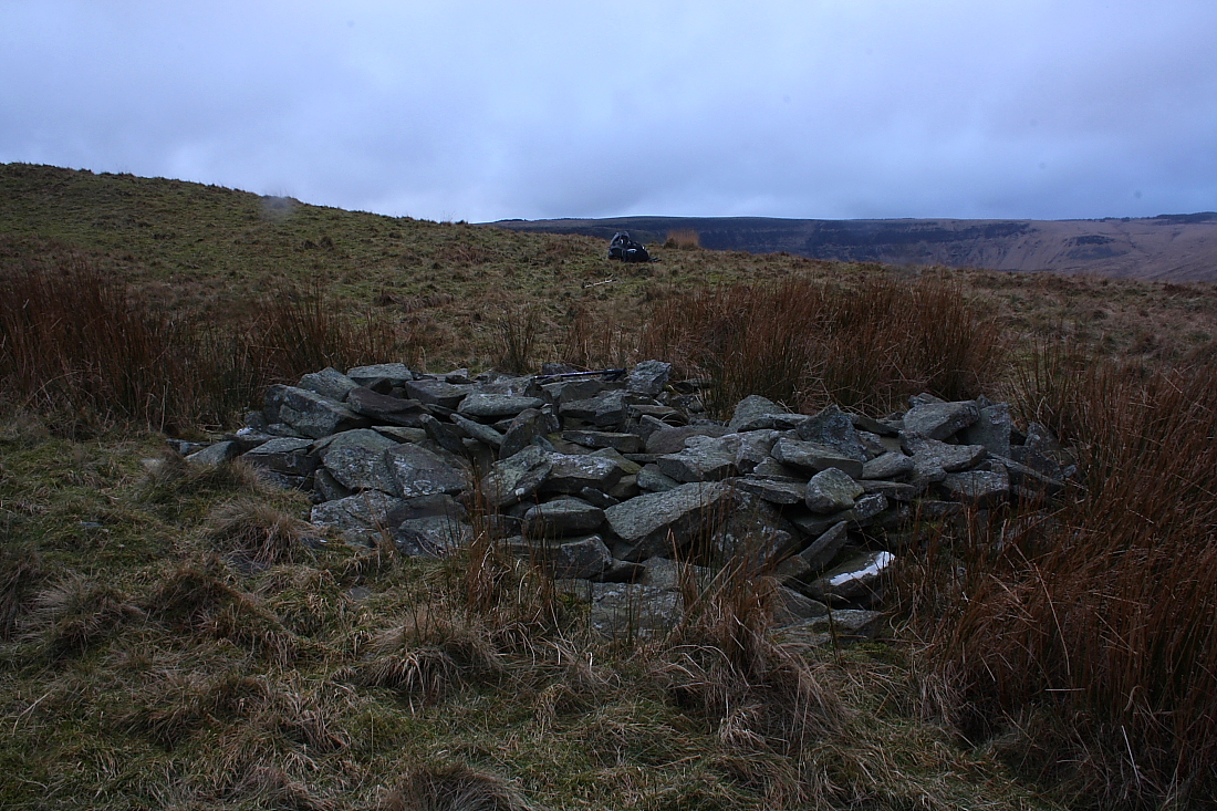
The ruinous remains of the cairn. Maindy Camp is visible as a brighter green area on the ridge in the middle distance behind.

The remains of the cairn in its upland location, looking east down the Rhondda Fawr. The odd conical bump on the skyline is Tylorstown Tip.
Visited 22.8.12
Didn’t think I would find this one but for a change I did!
Directions:
At the junction of the A4107 / A4061 there is a view point with a large car park.
Park here. (If you are lucky there is sometimes a burger van parked there)
Looking down the valley there is a ‘path’ running along the hillside to the right.
This is the ‘path’ which runs close to the Cairn. You cross a small stream on the way.
Looking at my notes and the terrain in front of me I didn’t expect to find this Cairn but thought I would try anyway.
It takes about 15 minutes to walk to the site and the Cairn is quite difficult to spot.
It is in amongst ‘spiky’ grass and consists of a small mound of stones.
Despite being a pretty bleak place to visit there are decent views to be had.
One best to visit on a nice day – if they ever have nice days up here?
I rejoin the bridleway and continue southwest. The ground climbs steadily now, then sharply, before levelling again to a crest just above the 450m mark. At the edge of this little plateau, the OS marks a further cairn. The views to the east over the Rhondda Valley and back to Maendy Camp have now opened up, and to the north the tops of the central Beacons, Corn Du, Pen y Fan and Cribyn are now visible. It takes me a while to find the cairn, supposedly a ring cairn. In the end, all that appears to be left is a pile of stones. There’s no obvious mound or ring at all and the pile itself is shapeless. Still, a good place to stop and enjoy the views, before the pull up to the top of the hill.


