Images

Image of Cwm Cowlyd (Ancient Village / Settlement / Misc. Earthwork) by thesweetcheat

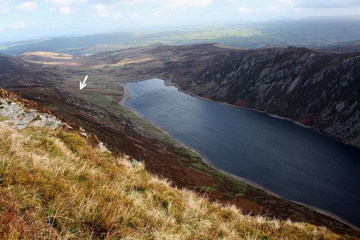
A reverse of Gladman’s dusk image, taken from the northern summit of Creigiau Gleision. The settlement would be far left I think. The hill in the centre is Moel Eilio, behind which is another settlement and the Cae Du ring cairn. Tal-y-Fan, surrounded by lots of sites, can be seen in the distance.

Image credit: A. Brookes (9.11.2014)
Image of Cwm Cowlyd (Ancient Village / Settlement / Misc. Earthwork) by GLADMAN

Highlighting the approx position of the settlement from near the summit of Pen Llithrig Y Wrach... any prospective visitors should note that it is possible to drive up a very steep road from Trefriw and park below the dam...

Image credit: Robert Gladstone
Image of Cwm Cowlyd (Ancient Village / Settlement / Misc. Earthwork) by GLADMAN

One of the Cwm Cowlyd hut circles? Looking across a very hostile Llyn Cowlyd towards Y Creigiau Gleision at dusk.... impossible to avoid camera shake. Obviously.

Image credit: Robert Gladstone

Articles

Miscellaneous

Cwm Cowlyd
Ancient Village / Settlement / Misc. Earthwork

The Gwynedd Archaeological Trust (PRN5546) cites several structures in upper Cwm Cowlyd as the remains of prehistoric ‘scattered hut circles’....

Unfortunately I arrived in the vicinity (on my return from Pen Llithrig y Wrach) with darkness fast drawing in, not to mention being subjected to vicious hail fronts moving down the cwm with ever increasing frequency.... hence just the one image at an extreme exposure limit, I’m afraid. I believe what I’ve captured is one of the hut circles, but a return visit is necessary to confirm this.

Sources :
Hut Circle Settlement Survey , SMITH, G. , 1998 , PRN 3990 , SHERRIFF, A. , 1983

Sites within 20km of Cwm Cowlyd