
The spectacular view from Mitchell’s Fold. March 2018
Image credit: Carol27
The spectacular view from Mitchell’s Fold. March 2018

Mitchell’s Fold was very cold March 2018. Snow all the way up (though you can’t see much of it here) and a biting, icy wind that turned us blue.

Mitchell’s Fold March 2018. Very bleak. VERY cold.


Coldest equinox ever!

Clouds conspire against me once more

Equinox sunrise March 2018


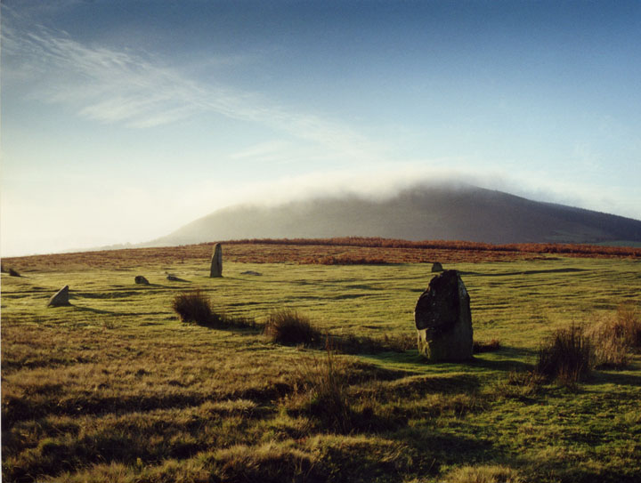
Towards snowy Corndon Hill. The hill to the left of centre is Heath Mynd.

A gloomy January day, but the circle’s magnificence more than compensates.

Approaching from the outlier.

September 2014

September 2014

September 2014

September 2014

September 2014

September 2014

I don’t know why I expected this circle to be bigger, it seems dwarfed by the width of the plateau of land it occupies. One of a series of sites in the area I guess it’s just one part of a much bigger picture.


The outlier, with the circle beyond.

Out in the midday sun.

The northern arc.

Stone has split along a natural fault.

This stone reminded me of a worked stone tool. The nearest edge looks almost as though it has been knapped, like a flint.

Looking NW towards the ranges of southern Snowdonia.

Looking NE towards Stapeley Hill.

Approaching from Stapeley Hill, with Corndon and Lan Fawr behind.

A touch of contemplation.


The sky on fire at moonrise...

Spooky Face Stone!


A wee bit of stone hugging going on!Duplex filter applied.

Alive! Taken at the king stone of Mitchell’s fold,salop.Long lens.

Taken at mitchell’s fold on the keystone,entitled ‘warmth of the sun‘

Medgel and a rainbow. Aaah!


Mitchell’s Fold – May 2006 – split stone

Mitchell’s Fold, May 2006

November 2005 – following 24 hrs of constant rain, the sun came out just in time for our walk up to Mitchell’s Fold.


It had rained constantly for 24 hours and then the sun came out!

A composite photograph from the top of Corndon Hill showing prehistoric sites present, destroyed, and possible around the Mitchell’s Fold / Stapeley Hill area.

The circle and its immediate surroundings in the thrall of Corndon Hill (for Rhiannon)

The views around to the SW and west are gorgeous, contrasting with Corndon Hill rearing up to the south and giving extra drama

The view away from Corndon Hill

The Witch stone and Corndon Hill


Mitchell’s Fold at the 2003 Winter Solstice sunrise


The Mitchells Fold outlier


The large upright at Mitchell’s Fold, July 2002.

Taken 20th July 2002: Mitchell’s Fold is on Common Land, so you’re not supposed to drive near it. In practise farm vehicles drive right past it (I was waiting for this one to go through the middle of the circle, but he skirted round it).

Taken 20th July 2002: There was serious rain bearing in on us from the west when I took this. The only view that wasn’t obscured by rain was this one (looking south west).

Summer Solstice 2002

Summer Solstice 2002

March 2002

March 2002

“Hey nonny no”

March 2002
View from Mitchell’s Fold


This stone was tipped over by a dickhead farmer back in 1997, it has now been re-erected.


Visited 8.4.2011. First, a little preface. My only other visit to Mitchell’s Fold was in August 1999, when I came with my Dad. It turned out to be our last day out together, as he died a few months later. Along with a visit earlier the same week to Four Stones, I treasure those days out, as we were probably closer then than we had been for a long time.
So, as I walk down Stapeley Hill, eager to get to the circle, I am suddenly hit by a powerful and unexpected wave of emotion. And it turns out to be anger. Anger that my Dad stupidly let himself drop dead, so that he isn’t here to share these visits with me. Blimey, perhaps you don’t get over these things as much as you think. And then it’s gone, passing as quickly as it arrived, like clouds across the sky on a windy day.
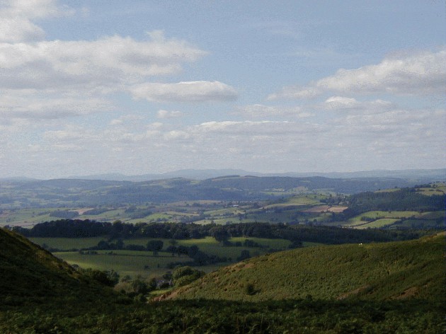
And without further ado, the circle is upon me. Or I’m upon it, rather. Although my previous visit is remembered fondly, I also remember it being busy. And I don’t remember the circle being quite so brilliant. But today I have it under a clear blue sky, all to myself. This is a magnificent site. A spacious ring of stones, of varying sizes up to a slender pillar, taller than I am. Corndon Hill looms to the south, an obvious relationship. But over to the west, the panorama of Mid-Wales and southern Snowdonia, across to Cader Idris, makes for a truly jaw-dropping setting.
The nearby outlier and cairn add to the sense of this being part of a complex setting, but there’s too little left to give enough clues. But then that’s how we like it, perhaps.
I spend a long while in and around the circle, still in splendid isolation. Eventually I must leave, as there’s still the long climb up Corndon ahead and the sun is beating down fiercely. Cheers Dad, I’m only sorry you weren’t with me on such a lovely day.
Visited 27.6.10.
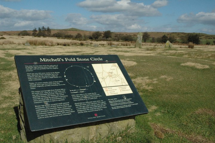
There is a small sign post off the A488 – near a bend so easy to miss. Follow the lane and up the rough track to the small car park. It’s only a 10 minute walk over the cattle grid and across the moor land to the stone circle. The stones are not visible from the car park but just walk straight ahead and you can’t miss them. There is a ‘remote’ feel about this site and lovely views to be had. There are a number of stones outside the circle which would easily fool me into thinking that they were more than ‘natural’. However, I know little about these things and I accept they are! An E.H. information board gives some interesting reading. The stone circle isn’t massively impressive but the location certainly is. There were ‘offerings’ placed around the top of the tallest stone in the circle – ribbons / leaves / flowers etc. Well worth a visit.
*** Before you turn right onto the track which leads to the car park there is a large cairn to be seen on your left. I have not been able to find any information about this cairn but it is worth a quick look when visiting the stone circle ***
Easy to find, clearly signposted and just a short walk from the nearest place to park Mitchell’s Fold is a cracking stone circle up on some heathland with glorious views all round.
Overlooked by the very close Corndon Hill, itself the site of a whole bunch of bronze age burial sites, most of the stones are just small stumps now, but one of two larger, taller stones remain. Here it definitely is a case of the sum being greater than the parts. We spent two hours here without even trying, just looking, enjoying the sunshine, lying in the grass, drinking in the tranquility.
Visited 20th July 2002: Having approached from the Chirbury direction we headed towards Mitchell’s Fold from the north west. There’s a footpath onto the common that follows a farmer’s track from this direction. In our ignorance we drove up this track to the edge of the common without realising that we would land up almost right next to the circle.
I wouldn’t drive this route again, armed with the knowledge that once you’ve started it you can’t easily park up or turn around until you’re there. Also anything less than a 4x4 would have trouble with it, and it’s embarrassing enough having a 4x4 without parking it next to a stone circle like some sort of klutz. Next time I think I’ll try approaching from another direction on foot!
Mitchell’s Fold is a very calm circle, and the views are spectacular. While we were there it threatened to rain really hard, and we had the pleasure of watching an enormous rain storm gentle roll towards us from Wales.
I’ve been here a number of times, it’s one of my favourite places. The views are terrific. It’s best to avoid driving down the muddy track, the walk is only 200 yards or so. There is a RoW onto Stapeley Hill which is worth the walk.
In ‘Secret Britain’, (published by Guild Publishing, London), it was said ‘that in lean times, a beautiful white cow appeared at Mitchell’s fold. No matter how many came to milk her, so long as each person filled just one pail, she would never run dry. But when an old witch called Mitchell milked her dry by milking her into a sieve she vanished, never to return.‘
In some versions the cow is said to have transformed into the rampaging Dun Cow of Dunchurch, Warks, which was eventually killed by Guy of Warwick.
The story of the Witch and the White Cow is said to have been attached to the circle in the 18th Century. At around the same time, another story told of ‘Medgel’s Fold’, a place where a giant kept his cows. The name is a suggestion that the circle was a ‘pound’ or ‘fold’ of a giant.
The story of the magic white cow is also associated with the stone circle at Callanish, Lewis.
Charlotte Burne (in Shropshire Folklore, 1883) related that:
There used to be more stones than there are now, but they have been taken away at one time or another. There was a farmer lived by there, and he blew up some of them and took away the pieces to put round his horsepond, but he never did no good after.
This circle is known in the neighbourhood by the name of Mitchell’s Fold. The traditionary story of which is – that within this circle an old man of the name of Mitchell kept a cow, which cow was indued with so much benevolence for the human race, that she contributed to the supply of almost all the wants of the surrounding peasantry, constantly suffering herself to be milked for any one’s benefit; and whatever was the quantity required by the person who was milking her, she supplied it. No vessel, however capacious, was suffered to return empty, nor to be only partially filled; till, at last, an old wicked hag of a witch, jealous of and hating so great a good, brought her pail and milked the generous beast; at the same time threw a spell over her, which prevented her from ever afterwards supplying her owner, or the neighbourhood with a single pailful.
p144 in ‘Museum Europaeum’ by Charles Hulbert (1825).
This version misses off the more satisfying ending which I know, viz, the cow was pretty disgusted and disappeared, never to be seen again – and meanwhile the witch was turned into the largest standing stone.
But on second thoughts, maybe the people were taking advantage of the overly generous cow – and the witch did a good job of saving the poor animal from Abuse. They didn’t have the RSPCA in those days you know.
There are apparently some good carvings of the story at a church at SO298993, done in 1879, which could be worth a look.
The story is mentioned in the third volume of ‘The Family Memoirs of Rev. William Stukeley’:
Cherbury, Shropshire.-- “A proverb in this country, ‘Medgelly’s cow, for one that gives a deal of milk.’ The report of this temple is that a cow in this place gave milk to all the honest and good folks of the neighbourhood; but one of evil life milked her into a sieve, whereupon the cow disappeared and never came more.” --1753. p179.
Stukely quoted in Edward Peacock’s contribution to
Notes and Queries
The Folk-Lore Journal, Vol. 6, No. 4. (1888), pp. 273.
I do like Mitchell’s Fold. Its wide wild views are fantastic. It has friendly horses sometimes too.
The Shropshire Tourism website (shropshiretourism.info/south-shropshire/mitchell_fold/) suggests King Arthur drew Excalibur out of one of the stones here. Apparently this was something recorded by William Stukeley [but see the comments below, perhaps this romanticism is more modern]. I guess it’s prime territory for Arthur, right on the border between England and Wales.
Here is some information about what else you may find around the circle, gleaned from the Shropshire sites and monuments record.
Mitchell’s Fold stone circle (also known as Medjices Fold and Madges Pinfold) is situated in a high saddle between Stapeley Hill to the north and Corndon Hill to the south. The stones were probably brought from Stapely Hill to the north west – they are all the same geologically.
It is thought there may be a central stone in situ below the turf. The interior of the circle is criss-crossed with lines – not all of them modern vandalism apparently, as the ridge is said to be the old coach route from Shrewsbury to Aberystwyth.
Ninety metres SE of the circle is a 0.7m standing stone on a small bump. Immediately north east of this is is a low mound believed to be the base of a robbed cairn – several stones show through the turf covering it.
Panoramic from the circle, clearly showing Corndon Hill – the source of many Neolithic axes.


