From up the slope to the southwest. The view would be towards Avebury and the Ridgeway.
Image credit: A. Brookes (22.12.2017)
From up the slope to the southwest. The view would be towards Avebury and the Ridgeway.

Some unidentifiable lump of iron farm machinery has been dumped on top of the mound.

Looking east towards Harestone Down.

Any surrounding ditch has been silted up.

From the northeast. The site of the next barrow in the group is near the tree in the background, left, but it’s so ploughed down as to be invisible on the ground.

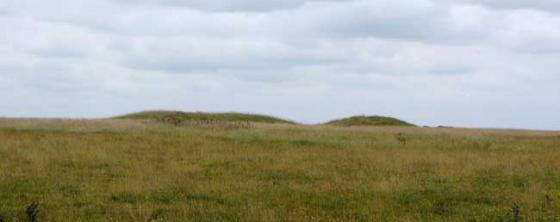
Landscape context for Allington Down from Harestone Down. Tan Hill is the highest hill, the Down runs NE on the skyline. The ploughed-down barrows are towards the high point, the much better-preserved survivor is just visible due to the darker bushes on it, above and to the left of the barns. The hill on the extreme right is Cherhill.

Looking up towards the top of the Down, NE barrow in centre of picture.

The NE barrow, looking WSW.

The edge of the NE barrow. Summer wouldn’t appear to be the time to go looking for a surrounding ditch!

The NE barrow, looking north towards Silbury.

Looking from the highest part of the down towards the NE barrow (with three bushes growing from it). The top of Silbury can just be seen to the left, peeking out from behind a clump of trees.

The site of the two SW barrows, ploughed to destruction.
Sadly the barrows on Allington Down have been rather less well-treated than their neighbours up on the ridge. Once a group of six, there’s nothing to see of all but one now. The plough has taken care of the rest. However, the one that does remain is very decent. It’s quite overgrown with nettles and long grass, topped with three shrubby May Trees in bloom, making it difficult to see whether there’s damage to its top.
I can see Silbury, peaking out from trees and indicating how far I still have to go to get to Avebury today. So I go.
Curiously, to support my speculation about a golden torc [see Tan Hill – Ed.], I found the following in M E Cunnington’s ‘Introduction to the Archaeology of Wiltshire’ (1949).
A piece of gold torque, or collar, weighing about 2 1/2 oz., was found by a man digging hard chalk on Allington Down, near Tan Hill, in 1844.* When the early Iron Age site at All Cannings Cross was being excavated in 1920-22 an old man who had known the finder of the torque gave the following account of its discovery. At first the finder thought it was brass, and hung it on a hurdle near where he was digging, and there it stayed for about a week; he must have had his doubts about it, for he then took it away and showed it to his master, who offered him half a crown for it; this he refused, because he thought, if the master was willing to give him half-a-crown, it’s likely as not to be worth more; so he took it to a bank in Devizes, where they soon found it to be solid gold, and thus led it to being claimed by the lord of the manor, the then Lord Ilchester, in whose family it is still.
I bet he wished he’d kept his mouth shut. The common law of treasure trove at the time was “when any gold or silver, in coin, plate or bullion hath been of ancient time hidden, wheresoever it be found, whereof no person can prove any property, it doth belong to the King, or to some Lord or other by the King’s grant, or prescription”. But I don’t suppose a poor digger had much chance of arguing it wasn’t ‘hidden’.
Anyway, so perhaps there was local knowledge that a gold torc had been found sometime in the past, and this had got converted/incorporated into the story below? Who knows the Complicated Workings of Folklore. Or it could really have been a ghost of course.
*(also see Wilts Arch Mag 36 p435)
The OS 1/25000 shows a linear group of four barrows, running SW-NE along the ridge of the Down. Pastscape indicates that there were six barrows originally. Only the NE barrow remains readily visible, due to ploughing and cultivation.
Pastscape descriptions:
SU08606540: 2 Bronze Age bowl barrows forming part of a linear round barrow cemetery containing 6 barrows in all running south west to north east across Allington Down. Both mounds are situated on an ancient boundary which is also the boundary between 2 farms. The north barrow has been reduced by cultivation and is 13 metres diameter and 0.2 metres high. The southern barrow has also been reduced and is only visible as a slight stony spread 12 metres diameter. An early track, now a public right of way, runs along the western side of the current field boundary which crosses the site. Scheduled.
SU 09176598: Bronze Age bowl barrow forming part of a linear round barrow cemetery containing 6 barrows on Allington Down. The mound is 13 metres diameter and 0.2 metres high. It is surrounded by a quarry ditch about 2.5 metres wide which now survives as a buried feature. In about 1900 2 sherds of Middle Bronze Age pottery and part of a human femur were found on the surface of the mound. The location of this barrow was originally plotted at SU 0916 6598 by the Ordnance Survey. Scheduled.
SU 09376619: Bronze Age bowl barrow forming part of a linear round barrow cemetery represented by 6 remaining barrows on Allington Down. The mound is 20 metres in diameter and 1 metre high. Middle and Late Bronze Age pottery sherds with burnt bone fragments have been found within the mound. Scheduled.