Skip to content
Julian Cope
presents
The Modern
Antiquarian
Latest
Posts
Sites
Map
Blog
Forum
search
Search
⚠️
Sign in
more_horiz
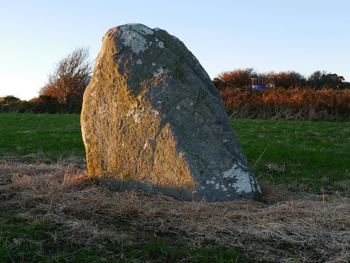
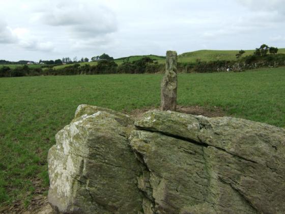
Eire
County Cork
Killacoosane
Standing Stone / Menhir
W238355
expand_more
Nearest town:
Leap (3km W)
OS reference:
W238355
OS sheet:
89
Latitude:
51° 34' 1.59 N
Longitude:
9° 5' 56.68 W
Added to TMA by
Meic
Images (6)
Add
content
Images
28th November 2012
Image credit: Michael Mitchell
Meic
Nov 29, 2012
28th November 2012
Image credit: Michael Mitchell
Meic
Nov 29, 2012
28th November 2012
Image credit: Michael Mitchell
Meic
Nov 29, 2012
28th November 2012
Image credit: Michael Mitchell
Meic
Nov 29, 2012
28th November 2012
Image credit: Michael Mitchell
Meic
Nov 29, 2012
28th November 2012
Image credit: Michael Mitchell
Meic
Nov 29, 2012
Sites within 20km of
Killacoosane
Drombeg
Stone Circle
•
0.95km E
photo
47
forum
1
description
8
link
2
Lettergorman (South)
Stone Circle
•
2.22km ENE
photo
36
description
3
Curraheen
Standing Stone / Menhir
•
3.6km ENE
photo
3
Carrigillihy
Standing Stones
•
3.86km SSW
photo
6
Carrigillihy
Cup Marked Stone
•
3.93km SSW
photo
8
description
1
Ballyroe
Dolmen / Quoit / Cromlech
•
4.04km NW
photo
7
description
1
Gurteenaduige
Stone Row / Alignment
•
4.84km WNW
photo
7
description
1
Tullig Stone
Standing Stone / Menhir
•
5.3km N
photo
2
description
1
Rosscarbery
Standing Stone / Menhir
•
5.71km ENE
photo
3
description
1
Killinga
Cup Marked Stone
•
5.97km NW
photo
5
description
1
Reanascreena
Stone Circle
•
6.12km NNE
photo
32
forum
3
description
5
Tinneel
Standing Stones
•
6.19km ENE
photo
7
description
1
Burgatia
Dolmen / Quoit / Cromlech
•
6.34km ENE
photo
4
description
1
Freahanes
Rath
•
6.56km NE
photo
7
Ahaglaslin
Portal Tomb
•
6.92km ENE
photo
2
forum
1
description
1
Bohonagh
Stone Circle
•
7.09km ENE
photo
36
forum
1
description
7
link
1
Gurranes
Stone Row / Alignment
•
7.44km WSW
photo
22
forum
1
description
3
Carrigagrenane SW
Stone Circle
•
7.87km N
photo
7
description
2
Knockdrum
Stone Fort / Dun
•
7.96km SW
photo
10
description
2
Derryduff
Standing Stone / Menhir
•
8.35km ENE
photo
4
Carrigagrenane NE
Stone Circle
•
8.45km N
photo
6
description
1
Sarue
Stone Row / Alignment
•
8.75km NNE
photo
6
forum
1
description
1
Reavouler
Standing Stone / Menhir
•
8.99km NW
photo
13
description
1
Maulatanavally
Stone Circle
•
9.06km NNE
photo
24
forum
1
description
2
Maulatanvally
Standing Stones
•
9.24km N
photo
6
description
2
Glanbrack
Stone Circle
•
9.61km NNE
photo
15
Garrygalss
Stone Circle
•
9.8km NNW
Garryglass
Stone Circle
•
9.82km NNW
photo
2
forum
2
description
1
Galley Head
Standing Stone / Menhir
•
10.77km E
photo
3
Inchinattin
Standing Stone / Menhir
•
10.82km NNE
photo
1
description
1
Knocks S
Stone Circle
•
10.86km NE
photo
16
description
2
Knockawaddra W
Stone Row / Alignment
•
10.95km NNE
photo
16
description
1
Knockawaddra E
Stone Row / Alignment
•
10.97km NNE
photo
14
description
1
Coolnagarrane
Standing Stone / Menhir
•
11.06km W
photo
1
description
1
Knocks
Stone Row / Alignment
•
11.39km NE
photo
12
description
1
Knocks
Standing Stone / Menhir
•
11.46km NNE
photo
1
description
1
Knocks N
Stone Circle
•
11.83km NNE
photo
19
forum
1
description
1
Coorleigh South
Cup Marked Stone
•
11.84km ENE
photo
8
forum
1
description
1
Knockatlowig
Stone Row / Alignment
•
12.11km NE
photo
8
description
2
Lettergorman (North)
Stone Circle
•
12.13km N
photo
23
description
2
Coolnaconarty
Standing Stones
•
12.35km NE
photo
8
description
1
Ahaghilla
Stone Circle
•
12.53km NE
photo
11
description
2
Milleennagun
Standing Stone / Menhir
•
12.54km NNE
photo
3
Milleennagun
Wedge Tomb
•
12.54km NNE
photo
11
description
1
Ballyvackey
Stone Circle
•
12.72km NE
photo
26
description
2
Abbeystrowry
Standing Stone / Menhir
•
13.26km WSW
photo
5
Baurnahulla
Dolmen / Quoit / Cromlech
•
13.78km WNW
photo
2
description
1
Lissangle
Standing Stone / Menhir
•
14.15km W
photo
5
Cloghboola
Standing Stone / Menhir
•
14.45km W
photo
5
Cashelisky
Standing Stones
•
14.48km NE
photo
8
forum
1
description
1
Bawnishall
Standing Stone / Menhir
•
14.52km W
photo
2
description
1
Caherkirky
Dolmen / Quoit / Cromlech
•
14.53km NNE
photo
8
description
3
Letter (site E)
Dolmen / Quoit / Cromlech
•
14.84km NE
photo
9
description
2
Shronacarton
Standing Stone / Menhir
•
14.99km WNW
photo
6
Barnabah
Cup Marked Stone
•
16.14km WSW
photo
2
Skeagh
Cairn(s)
•
16.57km W
photo
3
Ballyhalwick
Stone Row / Alignment
•
16.64km N
photo
3
Clodagh
Stone Circle
•
16.74km NW
photo
18
description
1
Clodagh Row
Stone Row / Alignment
•
16.81km NW
photo
10
description
2
Nedinagh West
Standing Stones
•
16.89km N
photo
3
Templebryan
Standing Stone / Menhir
•
17.05km ENE
Templebryan
Stone Circle
•
17.13km ENE
photo
18
description
4
Dunmanway North
Standing Stone / Menhir
•
17.5km NNW
photo
5
Foherlagh
Stone Row / Alignment
•
17.63km WSW
photo
8
Lyre
Standing Stone / Menhir
•
17.64km W
photo
6
Knocks (East)
Dolmen / Quoit / Cromlech
•
17.75km NE
photo
6
description
1
Inishbeg
Burial Chamber
•
17.77km WSW
photo
4
description
1
Ahidelake
Standing Stone / Menhir
•
17.82km E
photo
3
Garranes North
Standing Stone / Menhir
•
18.25km WNW
photo
5
description
1
Derrynasafagh
Standing Stone / Menhir
•
18.37km NNW
photo
2
description
1
Cullenagh
Stone Circle
•
18.53km NW
photo
10
description
1
Ballymacrown
Standing Stone / Menhir
•
18.55km WSW
photo
6
Hollyhill
Standing Stone / Menhir
•
18.63km WSW
photo
5
Cullenagh
Stone Row / Alignment
•
18.76km NW
photo
9
Darrary
Standing Stone / Menhir
•
18.94km ENE
photo
4
Lisnagun
Standing Stones
•
18.95km ENE
photo
6
description
1
Lissaclarig West
Stone Row / Alignment
•
19.76km W
photo
7
Like all websites everywhere,
we use
cookies
.
OK
search
I’m looking for…
location_on
photo
ondemand_video
forum
description
link