

A view of two of the pits, which are currently waterlogged, the embankment is behind them and two of the Three Howes in the background

I came across this little fella today on a relatively stoneless section of the moor. The stone is about 2 metres high and is situated on a slight rise just north of Danby Beacon, there is one other stone in the middle of the moor which has the look of a boundary marker
From Elgee’s Early Man In North-East Yorkshire
Pub 1930

Cross Section of Pit
After J.J. Burton

One of the many alligned pits with rucksack for scale

long stone

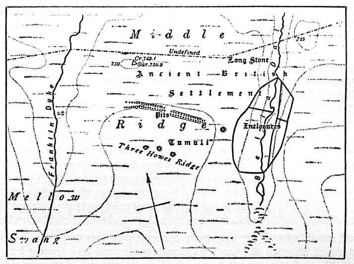
Long Stone with barrows & location of pit allignments

The Long Stone

boundary stone

boundary stone

boundary stone

Boundary stone
I was back on the moor today in search of Elgees enclosures in Bella Dale Slack themodernantiquarian.com/post/12986. The slack is completely waterlogged, thank god for G-Wax.
There is quite a defined bank & ditch on the westerly margins of the slack but as for his other enclosure walls, I’m not so sure.
I took a look at the pit alignment, one of the pits appears to have been excavated, I’m not sure whether this was done in the past or recently, I can’t recall it being there before.
This is a site that has puzzled the antiquarians for at least a hundred and fifty years, mainly because of it’s famous pits, but we come to that presently.
To get there you should park up in the Scaling Dam Sailing club car park, walk back out of the main gate, turn left past the wee clump of trees and then turn left again along the bridleway (quarry road). Follow the footpath over the various bridges and duckboards past the Boghouse beck and the end of the reservior. Turn south and head up onto the moor. You will see a number of prominant dykes and ditches along the way. I dont know the age of these features but judging from the standing stones along their margins, some of them are ancient.
The standing stones are marked on the map as BS, boundary stones, but unlike typical NYM boundary stones they are unworked natural monoliths with no markings upon them. Follow this track as it turns west and crosses the Bella Dale slack.
Presently you’ll come to the Long Stone, a handsome 3 1/2 -4m stone with some weathered lettering on the south face (the letter ‘c’ I think).
400m to your south you’ll see the Three barrows of Three Howes Rigg. I recommend you wander over to them and check out the famous pits.
Basically what you’ve got is a double alignment of circular pits bounded by a low dyke. The pits run in the same NNE SSW alignment as the barrows.
There is no sign of spoil around the pits and they are 3-4 m apart so I don’t think they are the result of mining activity. If anyone did want to mine the thin iron stone bands, they would have worked the two valleys that bound the area and I could find no evidence of any such activity. The pits are circular, about 3m diameter and ‘flush’ with the ground. About 200m from the eastern end of the pits is a large mound which I presume is another barrow. The theory that these pits were habitations seems a little bizzare, they seem more defensive, but defending what?
Beats the hell out of me!
Anyway check it out ,its a lovely place and the area is covered in barrows and lovely stones.
“Two miles east of the Herd Howe and one mile north of Danby Beacon is the celebrated ‘British Village’ on Easington High Moor, first described by Young, the scene of so many antiquarian pilgrimages, and the subject of so much discussion. This ‘village’ consists of two more or less paralell rows of circular pits lying across the central part of a spur between two small streams at an altitude of about 750 feet. The pits are in two groups, and on the outer side of each row runs a small wall of earth and stones. One of the pits near the middle of the south row is much larger than the others and interrupts the continuity of the outer wall. Excavations and probings show that the average depth of the pits is from 4-5 feet and that they vary from 10-12 feet in diameter.
In addition to this main group there is another group on the opposite side of the valley that bounds the spur to the east. As described by Young (1817) they begin near the verge of the sloping bank and extend eastward for over a hundred paces in a double row of 28 pits with an outer wall on both sides. a little to the south east is a similar double row of 6 pits also provided with outer walls.
Young was confident that these holes were ancient habitations. He commented on their proximety to the Three Howes, to standing or druidical stones (one of which, the Long Stone, stands a little to the north), and to two semilunar enclosures in the valley on the east, all of which he thinks were made and used by the same people.”
Early Man In North East Yorkshire
Frank Elgee
Pub 1930


