A visit starting at the car park below the hillfort.
I started along the road westish until the rough grassy track that obviously leads to the top of Birky Hill. ( OL42 map) . Upon gaining the summit of this low hill there are stones that look placed and are possibly the remains of well robbed burial cairns. This place needs a LiDAR survey like chips need salt. Just Northish down the slope is a large “square” looking chunk of rock with cup and rings on top. A basin has formed and another cup made in this. The other half of this stone is next to it and the break is obvious. There is another cup marked stone, which someone had torn the grass back from, revealing several I’d not seen, there appear to be lines connecting some of the cups.
Keeping to the grassy ridge you will meet a track that takes you across a piled stone line which apparently was the boundary of a deer park at some point, anyway , the Adder Stone ( aka Horseshoe Stone) is just along the way. I got a treat with bright sunshine low in the sky casting fine shadows ( there are lots of pics on here, mine are the same) it really looked like a snake today.
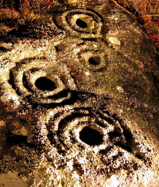
From here follow the deer park boundary stone pile thing uphill on the well used track to the “Main Stone” (aka Channel Stone). This is the prize of the bunch and was “busy” but everyone had time enough to themselves. Nice shadows revealing the mydrid cups and rings.
North East the track leads to the hillfort up a gentle slope. A boulder beside the track has possible sharpening marks but I have no idea of the origin weather ancient or more recent, it’s a good grit stone that I use at home for various things. I like to walk round the ramparts and today was as good as it gets for vegetation, it gets swamped with bracken in summer and the heather hides lots. There are “hut circles” dotted about. I’ve tried laying down in one and can’t ( I’m 5’10” on a good day). Views to enjoy in every direction and today I got the best of them.
Take your time strolling round the banks and when you get to the North look along the ridge and you will see the remains of a cain burial. A track leads that way and it makes a nice silluette on the skyline as you get close. The biggest stone has grooves down it which may be natural or accented by man. On the East side there are cup marks in one of the associated stones on the edge of the cairn site. You are looking down onto a watershed between you and the next hill and a stream flanked by small birch, alder and thorn can be seen leading down towards Rothbury. If you look towards the hill, East, there are several cup and groove marked slabs among the heather, I got lucky and found all the ones shown on here, some are fantastic. I took water to reveal the grooves better. It’s a job to know what is natural, what is manmade and what is a bit of both.
I then headed across the watershed and had a nose about on the low slopes of the hill but am leaving it for another day. I was 5 hours ambling, chatting, photographing and pondering. I could have done it in two but I had no rush today.
Wear your boots and tough pants, watch out for burnt heather stalks from land management, some areas are being used for grouse rearing and sheep so dogs are not allowed everywhere, signs advice, and there is plenty of space for everyone and their pooch. This is the time of year to visit before the bracken and heather cover it all up. This was my best visit for rock art because I used this site to learn before I went, and I’ve been coming here 30 years!