Ever wondered how a Wessex long barrow was constructed? Suffice to say the local fauna are about as meticulous excavators as the Victorians were in their day.
Image credit: Robert Gladstone
Ever wondered how a Wessex long barrow was constructed? Suffice to say the local fauna are about as meticulous excavators as the Victorians were in their day.

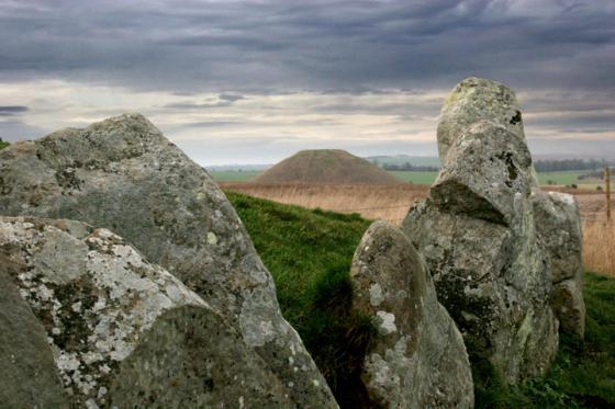
Liddington Hill’s copse – the hill fort is to its left – may not be as enigmatic as that at Minning Low... but it’s getting there. Note the position of the LB’s possible ‘chamber’. And the bloody fence splitting the monument in half.

There’s nothing like embedded stone upon an ancient mound to make this Gladstone glad he stopped by. Simple things..

Whereas this stonework appeared to possess proper structure, appeared integral to the monument?

Stonework upon the long barrow. I had the feeling this grouping was probably field clearance; but that’s just my hunch.

Toward Sugar Hill from the long barrow... I was debating with myself – as you do – whether the extension would be worth the effort. Suffice to say it is. Incidentally the excellent Aldbourne Four Barrows are located upon the hillside far right background.

The only glimpse most drivers get of the barrow looking up from the B4192. The damage to the Western side of the barrow is very evident from this angle.

The damage done by the erected fence of 1890 and the modern wildlife. This shot gives a good indication of the higher valley sides.

One of the protruding sarsen stones which may be part of the unexcavated burial chamber.

The Long Barrow with the Aldbourne Circular Route and bridleway stretches off towards Sugar Hill and down to the Aldbourne Four Barrows

All trace of the side ditches has been ploughed out or filled in.


The Long Barrow as seen from the Aldbourne Circular Route, the bridleway which runs along side the barrow.
Liddington Warren Farm Long Barrow – May 11th 2008
This long barrow sits on top of a ridge over looking the B4192 from Liddington to Aldbourne.
The road shows the precision of a Roman hand and I get the impression that this was the territory prized for it’s fertility. This whole area of the Ridgeway was rich agricultural land long before any Roman marched here.
The Aldbourne Circular Route, a bridleway/ride, follows the ridge and runs next to the barrow.
The way this route follows the top of this ridge, from the old Ridgeway at Liddington Castle down to the Aldbourne Four Barrows and on into the church at Aldbourne, is very processional. This whole area must had been the height of pre-roman achievement. Once the Romans came, it would had mushroomed into a major agricultural complex.
To visit this Barrow, I would suggest you park at SU 21822 80419, where the other cars pull up when visiting Liddington Castle, at the top of the hill. The traffic is slower here and you can see what’s coming. This road is an accident black spot, as the signs proclaim. If you park here, there is a stile leading into the field and a straight track directly up to the barrow. If you want to get nearer, park at SU 22035 80044 and get under the wire. The road past this point is tree lined with Horse Chestnut trees and can get very dark. It is very wide too, with well dug side ditches and numerous pieces of sarsen half buried. I could imagine it being a drover’s road, long before any car thundered along it.
It would have been the main road out to Cirencester, the second largest city in Roman Britian.
Walking up to the barrow you can see the fence line cutting the Eastern flank. This fence is the border. The parish was marked out on known landmarks and you don’t get much older a Neolithic Long Barrow. The barrow has been mutilated by man and beast. The black and whites are resident here and they have made quite a mess. When the fence was erected in 1890, three skeletons were dug from the barrow with a fourth, that of an adult male, was found later. The bones of at least one of these were forwarded to St Thomas’s Hospital. All are now lost.
The barrow mound is ovoid in plan and orientated WNW-ESE.. It survives to 42m in length, is 30m wide and stands 1.5m high. Although no longer visible at ground level, flanking ditches, from which material was quarried during the construction of the monument, run parallel to the north and south sides of the mound. These have become in filled over the years but survive as buried features 3m wide.
The barrow was first recorded by A.D. Passmore in 1922, who recorded a mound 165 feet long, 42 feet wide and up to 5 feet high, oriented SE-NW. Any sign of the side-ditches had been obliterated by ploughing. L.V. Grinsell was quoted as believing twelve sarsens protruding from the mound, although I could only see two. As it has never been properly excavated, these may be in situ from the original burial chamber. The hollow in the central area of the barrow mound represents only partial excavation by antiquarians, probably in the 19th century.
There might not be a lot to see at this barrow, but it does date from the same period of the ancient Ridgeway. It survived for 5000 years, but has only fallen into a ruin in the last 100 years.
Opening of two barrows on Liddington Warren Farm, N. Wilts, 1893.
The first barrow opened is close to a green road leading from Shepherd’s Rest to Marlborough. It is a bowl-shaped barrow, and as it has been ploughed over for many years it has spread over a considerable space, its diameter from north to south being about 68ft., and from east to west 80ft., whilst its height is now only about 4ft. A trench was started on the south-east side, and at 13ft. from the centre the edge of a cairn of sarsens was reached, 3ft. in depth and built up on the original surface-level. The stones were so evenly built in that it was with difficulty that a pickaxe could be forced between them. Following these along they were found to rise within 6in. of the surface of the tumulus. When these had been removed to a depth of 4ft. the original chalk level was reached, when a cist was found in the centre full of burnt hones, on the top of which was the rim of an imperfectly burnt urn, and a small turned conical button pierced under its base in pulley fashion with a hole for the string, apparently of Kimmeridge shale, similar in shape to specimens now in the Stourhead Collection at Devizes.The second barrow lies in a ploughed field near the 6th milestone from Swindon on the Hungerford Road. It seems really to consist of two barrows joined together. A trench was dug in the eastern most of the two, beginning on the south-east side. At 3ft. from the centre the bottom of an “incense cup” was discovered, and when within 1ft. of the centre the chalk on the original surface level was found to be of a dirty brown colour and was rammed down so hard that the pickaxe would hardly enter it. On the surface of this chalk, and not in a cist, under the centre of the barrow was a heap of burnt bones. Nothing else was found.
A. D. Passmore, Swindon
W.A.M. No. 27 pages 175 to 176
Wiltshire Web mentions that:
“This barrow is 150 feet long by 40 feet wide and only 4 feet high. The sarsens from the burial chamber protrude from the barrow. It is a local landmark used as a parish boundary. Three skeletons were found here in 1890 during the erection of a farm fence. ”