Looking northeast towards Crippets.
Image credit: A. Brookes (11.5.2024)
Looking northeast towards Crippets.

Eastern rampart, looking north.

The view from Barrow Wake, as the works to re-route the A417 carry on below.

Looking along the eastern ramparts towards Barrow Wake and Birdlip Camp.

Eastern ramparts.

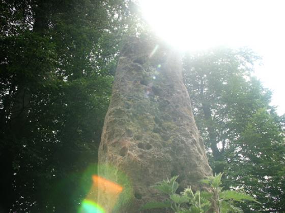
The Devil’s Table.

The overgrown limestone slab of the Devil’s Table, looking towards Cooper’s Hill with Gloucester and Robinswood Hill to the right.

Southern end of the ramparts.

Looking south towards the neighbouring promontory fort of Birdlip Camp (in the trees).

The ground falls away steeply to the southwest, before rising again to wooded Cooper’s Hill.

Deserted on Easter Monday. Looking across the Vale of Severn, with Robinswood and Churchdown Hills in the middle distance, the Malverns far right skyline.

Looking off the escarpment over the Vale of Severn. The outlying hills are Robinswood (far left), May Hill (centre) and Churchdown Hill (right). The Forest of Dean rises beyond.

The Neolithic long mound.

Later Neolithic fenced shrine and “processional way”, from the information board.

Depiction of the Neolithic long mound from the info board.

Looking along the eastern Iron Age rampart. The hill on the left is Churchdown (Chosen) Hill, a probable hillfort itself.

The Neolithic settlement area, looking towards the inside of the Iron Age eastern rampart.

The circular feature at the end of the Neolithic long mound.

The northern scarp slope provides natural defence.

Crickley Hill across Witcombe Reservoir. Birdlip Camp is on the far right.


The northern side of the fort and the Cotswolds escarpment.

The southwestern flank, looking towards Cooper’s Edge floating above the temperature inversion.

Below the Iron Age rampart.

Zoom on the Iron Age rampart, from Barrow Wake to the south.

Crickley Hill rises above the autumn temperature inversion filling the vale of Severn.

The linear Neolithic earthwork.

The enigmatic circular feature inside the Neolithic enclosure. Looking towards Cooper’s Edge and Gloucester.

The northwestern escarpment. Bredon Hill, with two forts, can be seen far left skyline.

The Iron Age ramparts.

Crickley Hill and neighbouring sites, seen from Cooper’s Hill Wood to the SW.

The impressive eastern rampart, looking north.

Looking SW from the ramparts across Witcombe Reservoirs to Cooper’s Hill, with High Brotheridge Camp rising slightly higher beyond.

Not the easiest thing to photograph, but the circular feature in the foreground is probably the most enigmatic aspect of the site (see fieldnotes). Churchdown Hill can be seen in the middle distance.

The very steep southern scarp face, looking across to Barrow Wake.

The northwestern aspect of the fort, where the natural scarp does much of the defensive work. Crippetts long barrow is hidden behind the tree line on the right skyline.


Walking along the ramparts of Crickley Hill hillfort

Towards Crickley Hill from the north-east...... approx south of Crippets Long Barrow.

The Iron Age rampart, from outside the fort.

The Iron Age rampart in freezing mist.

Looking south along the Iron Age rampart.


Crickley Hill from Barrow Wake. Churchdown Hill is on the left, with the Malverns along the horizon.

Crickley Hill (bare hill centre) and Birdlip Camp (right behind tree) seen from Witcombe Villa – see fieldnotes.

Looking along the Iron Age rampart. Churchdown Hill with its own hillfort is on the left, the Malvern Hills on the skyline.

The Neolithic earthworks, looking WSW(ish), with May Hill on the horizon

The Iron Age rampart viewed from the Neolithic settlement

The various trails around the hill top.

Crickley from Birdlip.
Beyond, not clouds but the Malverns floating above the mist.

Bank at E end of Neolithic settlement area.

There’s a bit of a view to the north north west....
(Shame my software can’t match the images up better – this is the best I can do)

The classic view of the settlement area from the east, looking roughly WSW

The area where the settlements were, from the west. I found it quite difficult to imagine huts amongst all the banks and mounds....

The inner ditch at the west and the unescapable stunning view to the north!

Looking out towards the north

view looking west over Gloucester – Brecon Beacons on the left, Malverns on the right
lovely

western wall defences
The National Trust says it has saved the site of one of the first battles known about on British soil which was under threat because of rabbits.
The site of the battle of Crickley Hill, near Gloucester, which took place more than 5,000 years ago between rival tribes, was in danger of being destroyed through erosion caused, largely, by rabbits.
The National Trust put up fences to stop erosion and back filled rabbit warrens to preserve the iron age hillfort.
Archaeologists said a major battle took place there in around 3,600BC, and the site was placed on the Heritage At Risk register until this year.
Walked up from Shurdington at the start of my sixth section of the Gloucestershire Way (17.4.2021) on a beautiful Spring morning.
The walk has already had a set-back due to the farmer at Greenfield Farm blocking the path, which leads to an annoying detour west then south, followed by a steep climb up from the A417. I’m out of practice at hills after a couple of months of being largely inactive as the latest lockdown combined with rubbish weather has kept me at home. My Gloucestershire Way efforts resumed a couple of weeks back on the flatlands of the Severn, this is the first uphill section since leaving May Hill and the Forest of Dean.
I’ve not come up here on this route before, and I had never heard of a limestone block called the Devil’s Table until route-planning. Like the Devil’s Chimney at nearby Leckhampton Hill, this appears to be a remnant of quarrying rather than a natural feature. When I get up there, puffing and panting, I find it’s partially buried in brambles, but it offers an excellent place to stop for a while, cool down and take in the extensive views across the Severn vale. I idly wonder why the quarrymen were so keen on giving Devilish names to their workings.
From here it’s a short pull up to the fort itself and familiar territory. It’s great to be back here on such a beautiful morning and the fort is quiet.
After a wander around in the sunshine, my route heads off through the lovely beech woods to the Air Balloon and then to Emma’s Grove round barrows.
My last visit to this fine site was in falling snow and a black and white world. Not so today. The walk through the woods of Crickley Hill Country Park to the northeast is lovely, sun streaming down. I stop at the Visitor Centre briefly, it’s usually been closed when I’ve been here before and it’s worth a look to see the information boards, together with some prehistoric finds and a model reconstruction of the site.
The site itself is quite magnificent, probably the best hillfort encountered so far along the Cotswold Way as, unlike Cleeve Cloud and Leckhampton Hill, it hasn’t been so badly damaged by quarrying (although it hasn’t entirely escaped). The Way passes through the impressive Iron Age ramparts that cut off a large wedge-shaped promontory. Inside this, various hut circles are marked out by concrete posts, although there’s nothing else remaining of them. The main features of the view today are Robinswood Hill and Churchdown Hill, two conical outlier of the Cotswold escarpment. The Malverns are but dimly seen through a haze more reminiscent of summer.
The most enigmatic part of the site is the circular feature at the northern end of the Neolithic earthwork, although little remains of it now. The circle, 8 metres across, was enclosed by stones and had a central hearth. “Ritual” purposes abounded, no doubt. From the western tip of the promontory, my route ahead comes into view for the first time, Barrow Wake across the steep-sided valley that now houses the A417, with Birdlip Camp, Witcombe Wood and Cooper’s Hill beyond. The Mother River, the Severn/Hafren, lies broad and glinting to the southwest.
It’s busy here today, as you’d expect on such a lovely day, and before long the impulse that pushes me onwards, away from the crowds, comes back. The Cotswold Way turns back along the southern edge of the promontory, where the ground falls away most steeply, before leaving the fort into yet another delightful beech wood.
I continue along the Cotswold Way to Crickley Hill. By now the snow has started to fall again and as I sit at a bench in the picnic area for a welcome cup of metallic tea I’m joined by a magpie, appropriately enough on such a monochrome day. I salute and wish him a good afternoon, after which he departs, apparently satisfied that the necessary dues have been paid.
By the time I enter the fort itself, through the entrance in the northeastern rampart, the snow is threatening to turn heavy. Freezing mist reduces visibility and photos start to become splodged. Needless to say, I am alone here today. After a circuit of the rampart, I make my excuses and leave through the woods to the east.
A beautiful, warm Autumn day, my first visit to Crickley Hill Country Park. The site of the neolithic settlement, hillfort and later roundhouses is impressive.
The following information was taken from a ‘time-line’ information board:
Archaeological investigation suggest the hill was intermittently inhabited for about 4000 years between 3500BC and 500AD. The soil on the hill is shallow but has never been ploughed so many of man’s past activities are recorded in not only the bedrock but also the subsoil. Excavations over the years have produced hundreds of thousands of finds, pieces of bone, fragments of pottery, daub from the walls of buildings, metal work, glass, charcoal, and various stones, many of which are foreign to the site.
A wonderfully evocative site with the later roundhouses marked out by circular ‘post’ marks. Spectacular views towards Cheltenham and Gloucester – the Malvern Hills just visible through the afternoon haze.
Visited 17.7.10.
My last site to visit of the day and what a site to finish on!
Easy to get to – well sign posted from the surrounding major roads and a large free car park with toilet facilities etc. There are plenty of visitor information boards around and the path to the Hillfort was easy enough to find. A very informative information board was at the entrance to the Hillfort giving time periods, site development and archaeological digs information. The ramparts are fairly well preserved and there were a series of different coloured concrete circles in the ground which I assume show the position of buildings? Unfortunately these were not mentioned on the boards. The main thing about the site has to be the view – simply stunning across into Wales. WOW!
Worth the visit for the view alone – you can see for miles and miles and miles….
Visited Witcombe R***n V***a and Birdlip Camp on 29.3.2009. Sitting in the sunshine at the Villa, the proximity to the two Iron Age settlements at Crickley and Birdlip is striking. The villa was constructed originally during the first century AD, during the early years of the occupation. Evidence of late Iron Age habitation and funerary practices has been found at Crickley and at Barrow Wake, which lies between Crickley and Birdlip.
Crickley had been an important high-status centre for 4,000 years by the time the Romans came, so the builders of the villa must have been able to impress their friends with the view of these former bastions of power.
Visited 1.2.2009 as it started to snow! There were still plenty of people up here, 12 or 15 cars in the car park. Nothing much to add to Moth’s access notes below, there are a couple of car parks and a toilet block, there are also a series of “trails” waymarked around the hill, one of which is the “Hillfort Trail”. NB: There are no litter bins, the idea is for people to take their litter home.
The bank and ditch of the Iron Age fort is quite impressive, the remains of the Neolithic settlement less obvious (although there is an information board). The position of various Iron Age features as determined by excavated post holes are marked by coloured concrete sunk into the ground.
As Moth said, the real reason for coming is the views, which despite the snow are stunning (I could even see Clee Hill, near where I grew up, which is 50 miles away).
From here I followed the Cotswold Way to Crippets long barrow and then Leckhampton Hill.
Although it’s very close to home it was only yesterday that I finally got to visit Cold Slad, bizarrely enough with kids on a trip from the school at which I work. The earthworks left me underwhelmed but the sense of place is fantastic with views as far as the Black Mountains.
Access sorry to say I can’t really remember, but here are my vague impressions.... It’s got a big car park and I reckon you can have at least a bit of a look around without having to go up steps or over stiles.
There might possibly be a gate or 2 that could be a bit awkward for wheelchairs. The ground is certainly fairly uneven in places and being a hillfort, there are some reasonably steep bits. The one thing I DO remember is that the (pretty helpful) info boards about the fort & settlement are on a raised platform that I’m pretty sure can only be reached by steps.
Monday 15 September 2003
I’d better start by saying that I know even less about hillforts, settlements and enclosures the like than I do about other stuff. And I don’t regard myself as very knowledgeable about the other stuff!
I must admit that they don’t interest me as much. I’m sure I’m missing out, but try as I might I can’t find the same ‘glamour’ and ‘mystique’ as at a stone circle or stone row, a long barrow or dolmen.
I do like ‘em though!!!
Probably the least surprising and certainly the first thing that struck me was that the views are stunning – looking out as Crickley Hill does, over miles and miles of plain, the Severn Valley and on to the Malverns. (Yes, it has those boards to show you notable places in the landscape, otherwise I’d not have known what I was looking at....)
The earthworks of the enclosure are fairly impressive, but I have to say that the mounds and dips where the settlements were left me fascinated but bemused. Couldn’t really work out what was going on there, even with the help of the informative info boards. Perhaps it was just me.
I ended up simply enjoying wandering around for half an hour, looking and wondering. It’s good for you sometimes I think – much better than giving yourself a headache trying to get your head round stuff that just won’t sink in.
Certainly a highly significant and interesting place and I’m heartily glad to have been there! Wouldn’t mind going back for another look sometime.
Details of site on Pastscape
Crickley Hill is a multiperiod site with occupation ranging from the early Neolithic until the fifth century AD. Features include a Neolithic causewayed enclosure, two phases of hillfort occupation, and Iron Age/Roman and sub Roman settlements.
It is a roughly triangular promontory projecting westwards from the Cotswolds edge. Excavations occurred at the site between 1969 and 1993, initially as part of a project focused on hillforts on the Cotswolds edge. The Crickley excavations uncovered evidence for a long sequence of intermittent activity on the hilltop ranging from the earlier Neolithic until the 5th century AD, with some more sporadic use after that date. The Neolithic and Early Bronze Age activity is described in SO 91 NW 43, the Late Bronze Age and Iron Age phases in SO 91 NW 44, and the Roman and Early Medieval occupation in SO 91 NW 45. During the Medieval period the northern slopes of Crickley Hill were used for grazing by Brinkworth parish. A small rectangular stone-walled building situated within the parish boundary may have been used as a shepherd’s hut. Post Medieval features on the hill include 17th century pits for limeburning, and activity which may have destroyed about an acre of the prehistoric settlements. Quarrying also removed substantial areas of the hill. Beginning in the 18th century, it had produced steep cliffs by the early 19th. Although in decline by the 1930s, the quarrying continued until the 1960s. An additional possible medieval or later feature is the long mound regarded by the excavator as being of Neolithic date, but suggested by some to be a pillow mound.
There was late pre-Roman iron age reoccupation of the hillfort within the entrance area, after a period of abandonment:
Dixon, P.W. 1994 Crickley Hill: The Hill-Fort Defences University of Nottingham
And a burial of the same date was located on the north slope of the hill:
Staelen, Yvette J. E. 1983 ‘The Birdlip Cemetery’ in Transactions of the Bristol and Gloucester Archaeological Society, 1982 Vol 100, pp. 19-32
Robert Bewley’s “Prehistoric Settlements” (Batsford 1994) says that the first occupation was a burial-less oval barrow before the causewayed camp came about. He also talks of the ‘shrine’ being associated with an orthostat and continuing in use long after the place was abandoned.
I’ve just been thumbing through Castleden’s Neolithic Britain, and came across the section on Crickley Hill. The site’s produced some pretty interesting finds – definitely some food for thought if you should trek up here.
The spur was originally cut off by two arcing ditches in the Neolithic, way before the Iron Age hillfort that you assume Crickley Hill is. The ditches were apparently filled and recut several times – rather strange, but this was done at other Neolithic causewayed enclosures too.
After they’d done with this stage the site was given even deeper ditches and a drystone wall rampart topped with a timber stockade. Inside there were houses and roadways – a fortified village. This is very uncommon for the Neolithic. There were two entrances closed by substantial gates (gathered from the size of the postholes), and round these were found over 200 arrow heads (I’m not one for too many material items, but ooh I’d love a neolithic arrowhead) and evidence of burning. The site was apparently attacked c. 2500bce (the late neolithic).
The western tip of the spur had been developed as a shrine area from early on – a cobbled stone platform surrounded by fences and approached by a narrow fenced path. A stone barred access directly to the platform from the path – the archaeologists could tell that people had walked round it to the left and passed through a gateway to get onto the platform. The platform was extremely free of finds (kept clean?), but at its edges were piles of bones and pottery and flints (offerings?). A small building was at the west of the platform, its open side facing the path, and fires were lit outside it.
The ritual platform was later destroyed, but about 400 years after its construction (c2300bce) the west end was covered with a cairn and a stone circle raised. The interior of the circle was cobbled, with a large slab at the middle (where they found evidence of burning).
The cairn was later extended to make a 100m long 4m wide mound, using topsoil from somewhere outside the site. At the east end of the mound was a paved semicircular forecourt and a large post hole (to hold what? Castleden suggests a ‘totem pole’). At the west end there was another paved area. Looking at the trampling, archaeologists were able to suggest that people processed along the side of the mound and then clockwise round inside the stone circle. Pretty cool if it’s true, because you usually imagine such information to be unknowable.
The long mound is still there on Crickley Hill, but not the stone ring which ‘has been reburied for its own safety’. Castleden concludes: “There is no surface trace of the destroyed Neolithic settlement, and, in fact, little to suggest that this is a key site in British archaeology.” I guess we’ll have to use our imaginations then, but that’s ok.
Park open every day from 6.00am [locked 6.00pm January, February, November and December; 7.00pm March and October; 9.30pm April, May, June, July, August and September.
Visitor centre is open during afternoons from 1st April until 30th September
Toilets, including disabled facilities
Picnic benches
Barbecues: Six steel barbecues on site for your use free of charge, bring your own charcoal. They cannot be reserved. You may bring your own barbecue and use it at the barbecue site; they should not be set up on the wooden picnic tables
All terrain mobility scooter for hire
View Crickley Hill Country Park in a larger map
Car parking charges:
£1.00 for up to 2 hours
£2.00 for up to 4 hours
£3.00 all day
Alternatively, purchase season ticket parking (£15 per month, £45 per quarter, £150 per year)
The charging period is all year, 6am – 6pm