
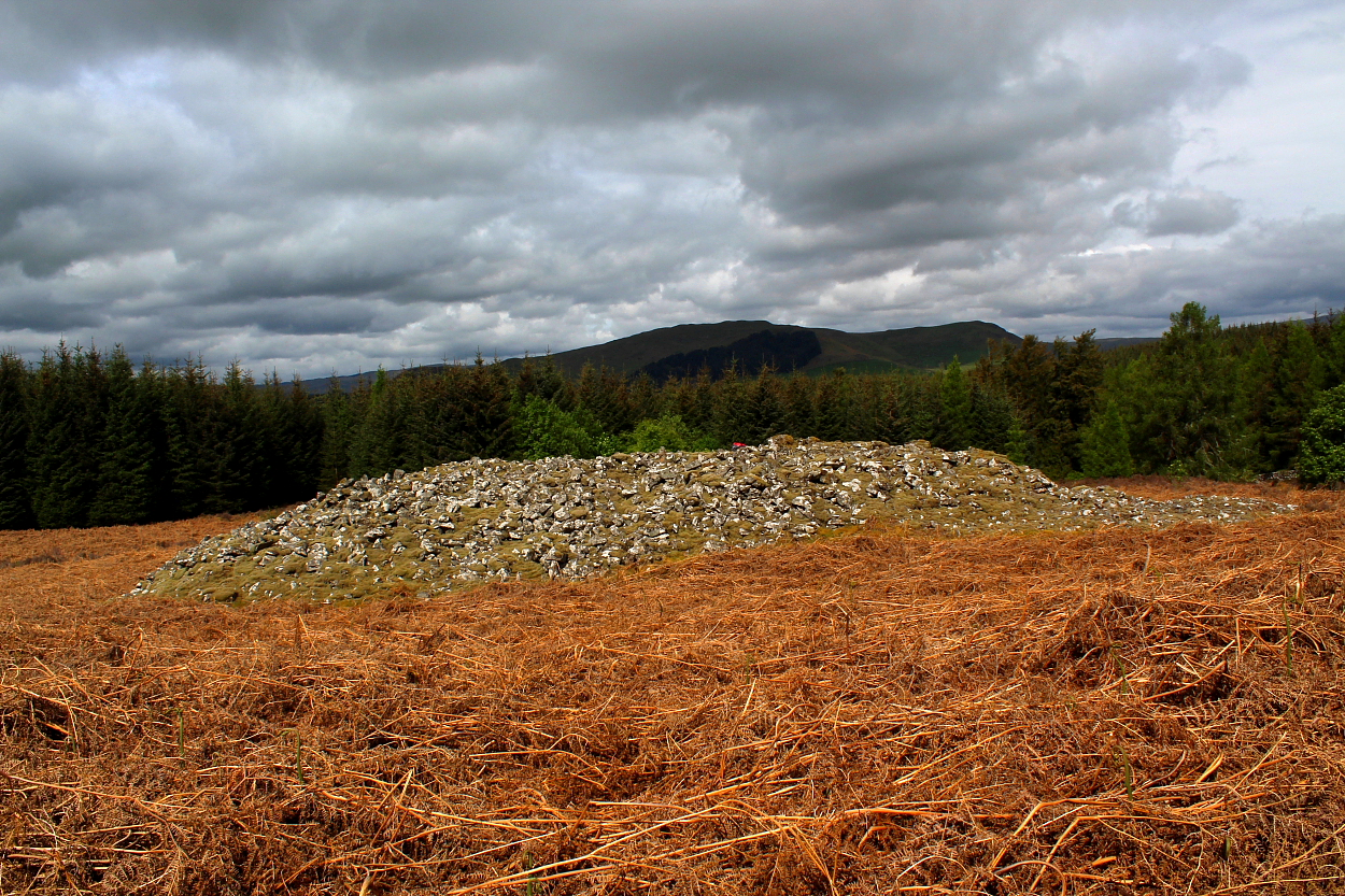
Capenoch Loch Cairn NE-SW Axis viewed from NE. The NE half has largely been stone robbed. (07.04.12)
Image credit: Mark Johnstone
Capenoch Loch Cairn NE-SW Axis viewed from NE. The NE half has largely been stone robbed. (07.04.12)

Capenoch Loch Cairn NE-SW Axis viewed from SW. Two excavated hollows are visible along the axis. (07.04.12)
I had intentions to also visit the nearby fort of Tynron Doon before heading north... however, the vibe here was so exquisite I stayed for the full term.


I initially thought this end of the long cairn was the result of stone robbing... but left reckoning this ‘horn’ was maybe part of the design? However Audrey Henshall disagrees – and she knew a bit about cairns, to be fair – so upon reflection, best go with her!

There’s something about mossy cairns that connects with the primaeval in me...

Concur with Greywether... 15 years after the event: a very well preserved long cairn, this.

General view from E.
The cairn is 34m long x maximum 16m wide. Up to 3m high.
Bogrie Hill in the distance.

SW end

NE end
Directions to Capenoch Loch Long Cairn
The path starts in a gateway opposite Barr Farm on the A702 between Moniaive and Penpont. The farmer has prohibited parking in this gateway. Due to this restriction an extension of 0.33 miles N to the nearest lay-by at NX 82877 92845 is necessary. A forest track heading NE starts opposite Barr Farm. Follow the track for c. 0.35 miles to reach a junction. Turn right then bear right after c. 80 yards. Follow the track SE for c. 0.3 mile to NX 8375 9244. Head N up a narrow forest ride for c. 100 yards. Capenoch Loch Long Cairn is c. 80 yards NE in the centre of a large clearing. My route can be viewed on Capenoch Loch Long Cairn.
Visited 07.04.12
Capenoch Loch Long Cairn is located in a large forest clearing c. 250 yards SE of Capenoch Loch, c. 1.5 miles SSW of Penpont, a village in Dumfries and Galloway. The stony mound measures c. 36 yards on the NE-SW long axis. The transverse axis tapers from c. 17 yards at the SW end to 9 yards at the NE end. The NE half has been stone robbed to ground level but the SW half is relatively intact reaching up to 9 feet high. There are two excavated hollows along the NE-SW axis in the SW half but no chambers are visible on the cairn.
Furter detail of Capenoch Loch Long Cairn are available in Canmore ID 65334.
This long cairn, unlike many in SW Scotland, has not been mucked about to build sheep pens or field walls. It is therefore a good, well-preserved and easily accessible example of this type of monument.
It sits in an elevated position (170m) near a stream in a forest clearing which to the W is currently new plantation – so the views SW to Bogrie Hill (432m) are maintained.
Surrounded at the time of my visit with chest-high bracken – not the best time to go there!
Access Park opposite Barr House (NX833923) where permission can be obtained. Walk NE up the track towards the loch shortly before which the cairn becomes visible on the right.
Visited 9 September 2004
From Robert Gladstone:
“I am the owner of this site. I welcome public access on foot, but would like to correct the website entry. Parking is not allowed at Bar Farm on the A702. This access and gate is in constant use by farm and timber traffic. Parking is possible at a laybye on A 702 200 meters to East of Ford farm roadend.”


