Skip to content
Julian Cope
presents
The Modern
Antiquarian
Latest
Posts
Sites
Map
Blog
Forum
search
Search
⚠️
Sign in
more_horiz
United Kingdom
England
Southern England
Devon
Dartmoor
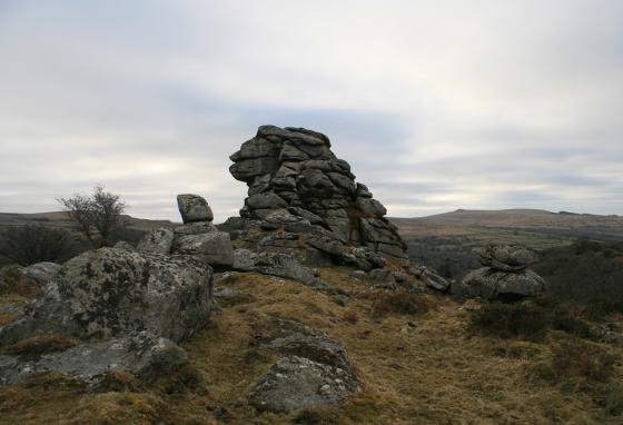
Gutter Tor
Natural Rock Feature
SX578669
expand_more
Nearest town:
Plympton (11km SSW)
OS reference:
SX578669
OS sheet:
202
Latitude:
50° 29' 2.43 N
Longitude:
4° 0' 16.7 W
Added to TMA by
Lubin
Images (2)
Add
content
Images
A rock basin on the top of the Tor.
Image credit: Peter Castle ©
Lubin
Jun 1, 2007
A rock basin on the top of the Tor.
Image credit: Peter Castle ©
Lubin
Jun 1, 2007
Sites within 20km of
Gutter Tor
Gutter Tor Cist
Cist
•
0.22km WSW
photo
12
description
1
Gutter Tor settlement
Ancient Village / Settlement / Misc. Earthwork
•
0.22km SSW
photo
3
Gutter Tor cairns
Cairn(s)
•
0.54km W
photo
6
Whittenknowles Rocks Settlement
Ancient Village / Settlement / Misc. Earthwork
•
0.73km ENE
photo
8
description
1
Yellowmead SE cairn
Cairn(s)
•
0.85km NNW
photo
3
description
2
Yellowmead Multiple Stone Circle
Stone Circle
•
0.95km NW
photo
52
forum
3
description
11
link
3
Willings Wall Warren
Ancient Village / Settlement / Misc. Earthwork
•
1.1km SSE
photo
3
Eylesbarrow South West
Cist
•
1.2km NE
photo
9
description
2
Ditsworthy Cairn Circle
Cairn circle
•
1.3km SE
photo
1
description
1
Outcombe
Cist
•
1.3km N
photo
1
description
1
Ringmoor Down cairns
Cairn(s)
•
1.34km WSW
photo
3
Drizzlecombe Megalithic Complex
Complex
•
1.41km ENE
photo
116
description
8
link
1
Legis Tor Cist
Cist
•
1.45km S
photo
5
description
1
Ditsworthy Warren
Cist
•
1.53km ENE
photo
7
description
1
Willings Walls Warren cist
Cist
•
1.74km SSE
photo
2
Ringmoor Down Cist
Cist
•
1.77km SW
photo
3
description
1
Ringmoor Cairn Circle and Stone Row
Stone Row / Alignment
•
1.8km SW
photo
52
description
7
link
3
St Leonard’s Well
Sacred Well
•
1.83km W
photo
2
description
2
Hen Tor North /
Shavercombe Brook
Cairn(s)
•
1.84km ESE
photo
7
description
1
Brisworthy Stone Circle
Stone Circle
•
1.91km SW
photo
57
forum
1
description
8
link
1
Higher Hartor Tor
Round Cairn
•
1.92km ENE
photo
3
description
1
Ringmoor Kerbed Cairn
Kerbed Cairn
•
1.92km WSW
photo
6
Cuckoo Rock
Ancient Village / Settlement / Misc. Earthwork
•
1.93km NNE
photo
2
description
1
Trowlesworthy Warren
Cist
•
2.31km SSW
photo
1
description
1
Down Tor South
Cist
•
2.31km N
photo
2
description
1
Plym Steps Round Cairn
Round Cairn
•
2.4km ENE
photo
5
Trowlesworthy
2.4km S
Little Trowlesworthy Tor
Ancient Village / Settlement / Misc. Earthwork
•
2.4km S
photo
2
Plym Steps
Ancient Village / Settlement / Misc. Earthwork
•
2.46km ENE
photo
10
Down Tor
Stone Row / Alignment
•
2.53km NNE
photo
69
forum
1
description
7
link
1
Willings Walls Reave
Ancient Village / Settlement / Misc. Earthwork
•
2.55km SSE
photo
1
description
1
Down Tor NW
Round Cairn
•
2.56km NNE
photo
1
Spanish Lake
Cist
•
2.59km SE
photo
1
Hingston Hill North
Cist
•
2.65km N
photo
3
Ringmoor Down Reave
2.69km WSW
photo
1
Eylesbarrow
Cairn(s)
•
2.7km NE
photo
15
description
3
Narrator Brook Head enclosure
Enclosure
•
2.87km NNE
photo
9
description
2
Langcombe Brook /
Deadman’s Bottom
Cairn(s)
•
2.89km E
photo
35
description
1
Narrator Brook Head cairn
Cairn(s)
•
2.89km NNE
photo
10
description
1
Trowlesworthy Warren
Stone Circle
•
2.9km S
photo
24
description
2
link
2
Trowlesworthy Stone Row West
Stone Row / Alignment
•
2.91km S
photo
20
description
3
link
1
Leather Tor South
Cist
•
3km NW
photo
2
Trowlesworthy Stone Row East
Stone Row / Alignment
•
3km S
photo
17
description
3
link
1
Calveslake Tor
Cairn(s)
•
3.05km ENE
photo
2
description
1
Grim’s Grave
Ring Cairn
•
3.42km E
photo
14
description
1
Tory Brookhead
Cairn(s)
•
3.49km SSE
Shell Top
Cairn(s)
•
3.63km ESE
photo
3
Tory Brookhead
Enclosure
•
3.66km SSE
photo
7
Wigford Down
Cairn(s)
•
3.71km WSW
photo
11
description
1
Peek Hill
Ring Cairn
•
3.71km WNW
photo
1
description
1
Emmets Post
Cairn(s)
•
3.83km S
photo
1
description
1
Great Gnat’s Head
Cairn(s)
•
3.92km ENE
photo
2
description
1
link
1
Wigford Down
Ancient Village / Settlement / Misc. Earthwork
•
3.97km WSW
photo
2
Raddick Hill
Cairn(s)
•
4km NNW
photo
17
Saddlesborough summit cairns
Cairn(s)
•
4.11km SSW
photo
3
description
1
Leeden Tor South
Cist
•
4.14km NW
photo
1
description
1
Saddlesborough settlement
Ancient Village / Settlement / Misc. Earthwork
•
4.16km SSW
photo
9
description
1
Saddlesborough
4.2km SSW
West Saddlesborough Hut Circles
Ancient Village / Settlement / Misc. Earthwork
•
4.24km SW
photo
8
description
2
West Saddlesborough Stone Row & Cairn Circle
Stone Row / Alignment
•
4.24km SW
photo
19
description
3
Sharpitor
Multiple Stone Rows / Avenue
•
4.25km NW
photo
10
description
5
Sharpitor Cist
Cist
•
4.28km NW
photo
3
description
2
Sharpitor cairns
Cairn(s)
•
4.29km NW
photo
16
description
2
West Saddlesborough Cairn
Cairn(s)
•
4.29km SW
photo
5
description
2
Penn Beacon
Cairn(s)
•
4.51km SE
photo
2
Fox Tor Mire
Cist
•
4.54km NE
photo
1
description
1
Black Tor
Stone Row / Alignment
•
4.54km NNW
photo
17
Cholwich Town (destroyed)
Stone Row / Alignment
•
4.65km SSE
photo
1
description
2
Horseyeatt
Stone Row / Alignment
•
4.71km WNW
photo
4
description
1
Dewerstone Settlement
Ancient Village / Settlement / Misc. Earthwork
•
4.79km SW
photo
4
description
4
Hart Tor
Stone Row / Alignment
•
4.8km NNW
photo
45
forum
1
description
3
Penn Beacon South
4.87km SE
photo
3
Black Tor
Rocking Stone
•
4.91km NNW
photo
8
description
1
Goldsmith’s Cross/
Fox Tor Mire
Cist
•
5.1km NE
photo
4
description
1
Shell Top South West
Enclosure
•
5.23km SW
photo
9
Collard Tor
Stone Row / Alignment
•
5.24km SSW
photo
11
description
1
Ranny Brook
Ancient Village / Settlement / Misc. Earthwork
•
5.33km ESE
photo
3
description
1
Ingra Tor
Cist
•
5.47km NW
photo
1
description
1
Dendles Waste
Cist
•
5.59km ESE
photo
1
description
1
Devil’s Gully Settlement
Ancient Village / Settlement / Misc. Earthwork
•
5.59km N
photo
8
Childe’s Tomb
Cist
•
5.71km NE
photo
5
description
2
Stall Moor Stone Row
Stone Row / Alignment
•
5.85km ENE
photo
12
description
2
Yes Tor Bottom
Ancient Village / Settlement / Misc. Earthwork
•
6km NNW
photo
1
description
1
Erme Pound
Ancient Village / Settlement / Misc. Earthwork
•
6km E
photo
4
description
1
Stall Moor Cairn
Cairn(s)
•
6.02km E
photo
5
description
2
Erme Plains
Ancient Village / Settlement / Misc. Earthwork
•
6.11km E
photo
1
Stall Moor Stone Circle
Stone Circle
•
6.2km E
photo
15
description
6
link
1
Coombebrook North East
Cairn(s)
•
6.28km ESE
photo
1
description
1
Broken Barrow
Round Cairn
•
6.43km NE
photo
10
description
1
Hook Lake
Stone Row / Alignment
•
6.43km E
photo
3
description
1
Hook Lake
Enclosure
•
6.47km E
photo
4
description
1
Ter Hill
Cist
•
6.51km NE
photo
2
description
1
Blatchford Bottom settlements
Ancient Village / Settlement / Misc. Earthwork
•
6.55km E
photo
3
Harrowthorn Plantation North
Cairn(s)
•
6.56km ESE
photo
1
description
1
Royal Hill Cist
Cist
•
6.67km NE
photo
24
Royal Hill
6.76km NE
Stalldown Cairns
Cairn(s)
•
6.78km ESE
photo
6
description
1
Stalldown Stone Row cairns
Cairn(s)
•
6.96km ESE
photo
4
description
2
link
1
Stalldown cairn circle
Cairn circle
•
7.01km ESE
photo
5
Stalldown Stone Row Cairn NE
Cairn(s)
•
7.04km ESE
photo
4
description
2
The Crock of Gold Cist
Cairn(s)
•
7.07km NNE
photo
4
forum
1
description
3
Stalldown Stone Row
Stone Row / Alignment
•
7.08km ESE
photo
40
forum
1
description
6
link
2
Stalldown Stone Row Cairn S
Cairn(s)
•
7.38km ESE
photo
3
description
2
link
1
Joan Ford’s Newtake
Cist
•
7.41km NE
photo
3
description
1
Pecked Circle
Stone Circle
•
7.42km NE
description
1
Hillson’s House
Cairn(s)
•
7.54km ESE
photo
5
description
2
link
1
Hucken Tor
Natural Rock Feature
•
7.55km NW
description
1
link
1
Western White Barrow
Cairn(s)
•
7.62km E
photo
9
description
3
Yellowmeade
Cist
•
7.64km NNW
photo
2
description
1
Blakey Tor
Cist
•
7.68km NNE
photo
5
description
1
Roborough Beacon
Enclosure
•
7.74km WSW
photo
8
description
2
Buckland Ford Cairn Circle
Cairn circle
•
7.96km E
photo
10
Boringdon Camp
Hillfort
•
8.04km SSW
photo
13
description
1
Merrivale Stone Circle
Stone Circle
•
8.09km NW
photo
39
description
3
Swincombe Ford Newtake
Cairn(s)
•
8.12km NE
photo
2
Round Hill
Cairn(s)
•
8.18km NNE
photo
8
Stalldown South-East
Ancient Village / Settlement / Misc. Earthwork
•
8.18km ESE
photo
8
description
2
Skir Hill
Cairn(s)
•
8.21km ENE
photo
1
Vixen Tor
Cist
•
8.22km NW
photo
14
description
4
link
1
The Plague Market At Merrivale
Multiple Stone Rows / Avenue
•
8.23km NW
photo
105
description
19
link
1
Heap of Sinners
Cairn(s)
•
8.37km ENE
photo
11
ondemand_video
1
description
2
Huntingdon Warren Settlement
Ancient Village / Settlement / Misc. Earthwork
•
8.49km E
photo
1
description
1
Merrivale Bridge Settlement
Ancient Village / Settlement / Misc. Earthwork
•
8.59km NW
photo
8
forum
1
description
1
Ryder’s Hill
Cairn(s)
•
8.61km ENE
photo
2
description
1
Maristow Camp
Enclosure
•
8.66km WSW
Three Barrows
Cairn(s)
•
8.67km E
photo
10
Sherberton Stone Circle
Stone Circle
•
8.75km NE
photo
26
description
4
link
1
Sharp Tor
Cairn(s)
•
8.8km ESE
photo
5
description
1
Biller’s Pound
Ancient Village / Settlement / Misc. Earthwork
•
8.81km E
photo
2
description
1
Barn Hill /
Whitchurch Down
Cist
•
8.82km NW
photo
1
description
2
Eastern White Barrow
Cairn(s)
•
8.85km E
photo
9
ondemand_video
1
description
1
Burford Down
Stone Row / Alignment
•
8.98km ESE
photo
18
description
5
Snowdon
Cairn(s)
•
8.99km E
photo
6
description
1
Burford Down cairn and cist
Cairn(s)
•
8.99km ESE
photo
8
description
1
Piles Hill stone row
Stone Row / Alignment
•
9.22km ESE
photo
3
description
1
Down Ridge
Stone Circle
•
9.31km NE
photo
12
description
2
Pupers Hill
Cairn(s)
•
9.38km ENE
photo
11
ondemand_video
1
description
3
Harford Moor
Cist
•
9.45km ESE
photo
15
description
2
Piles Hill cairns
Cairn(s)
•
9.58km ESE
photo
8
description
2
Little Mis Tor
Ancient Village / Settlement / Misc. Earthwork
•
9.62km NNW
photo
8
Long Plantation
Cup and Ring Marks / Rock Art
•
9.68km N
photo
1
forum
1
description
1
link
1
Holne Moor
Cist
•
9.72km ENE
photo
1
description
2
Piles Hill longstone
Standing Stone / Menhir
•
9.78km ESE
photo
12
description
2
Brockhill Foot West
Ancient Village / Settlement / Misc. Earthwork
•
9.98km E
photo
9
description
1
Brockhill Enclosed Settlements
Ancient Village / Settlement / Misc. Earthwork
•
10.03km E
photo
1
Brockhill Ford West
Cairn(s)
•
10.05km E
photo
2
Mardle Valley
Cairn(s)
•
10.13km ENE
photo
1
description
1
Butter Brook Ford
Ancient Village / Settlement / Misc. Earthwork
•
10.2km ESE
photo
5
description
1
Glasscombe Ball
Cairn(s)
•
10.2km ESE
photo
3
description
2
Great Western Reave
Ancient Village / Settlement / Misc. Earthwork
•
10.21km NW
photo
1
description
1
Glasscombe Ball North
Stone Row / Alignment
•
10.21km ESE
description
1
Dunnabridge Pound
Ancient Village / Settlement / Misc. Earthwork
•
10.25km NE
photo
4
description
2
Glasscombe Corner
Stone Row / Alignment
•
10.27km ESE
photo
11
description
2
Rider’s Rings
Ancient Village / Settlement / Misc. Earthwork
•
10.3km E
Butterdon stone row
Stone Row / Alignment
•
10.31km ESE
photo
16
forum
1
description
3
Corringdon Ball Stone Row
Multiple Stone Rows / Avenue
•
10.32km E
photo
15
description
1
Cox Tor
Cairn(s)
•
10.36km NW
photo
2
description
1
Dean Moor
Cairn(s)
•
10.5km E
photo
8
forum
1
description
1
Holne Moor Triple Row
Stone Row / Alignment
•
10.54km ENE
photo
2
Corringdon Ball Long Barrow
Long Barrow
•
10.6km E
photo
14
description
1
Spurrell’s Cross Stone Row
Stone Row / Alignment
•
10.67km ESE
photo
6
description
2
Glaze Meet
Cairn(s)
•
10.69km ESE
photo
3
description
1
Wistman’s Wood
10.71km NNE
photo
2
description
2
Weatherdon Hill
Cairn(s)
•
10.73km ESE
photo
2
description
1
Black Newtake
Cairn circle
•
10.83km NE
photo
9
description
1
Butterdon Hill (north) cairn
Round Cairn
•
10.84km ESE
photo
3
description
1
Gripper’s Hill
Cairn(s)
•
10.85km E
photo
13
ondemand_video
1
description
1
Aller Brook
Cist
•
11.02km ENE
photo
1
description
1
Addicombe
Ancient Village / Settlement / Misc. Earthwork
•
11.13km ESE
Roos Tor Northeast
Cairn(s)
•
11.14km NW
photo
1
Butterdon Hill cairns
Cairn(s)
•
11.22km ESE
photo
21
description
2
Butterdon Hill cairn circle
Cairn circle
•
11.23km ESE
photo
4
description
2
Littaford Tor
Ancient Village / Settlement / Misc. Earthwork
•
11.28km NNE
photo
1
Laughter Tor
Standing Stone / Menhir
•
11.32km NE
photo
7
description
4
Langstone Moor
Enclosure
•
11.32km NNW
photo
3
Langstone Moor
Cairn(s)
•
11.39km NNW
photo
4
description
1
Bellever Tor West
Cist
•
11.44km NNE
photo
8
description
1
Langstone Moor Stone Circle
Stone Circle
•
11.48km NNW
photo
18
forum
1
description
4
Harbourne Head cairns
Cairn(s)
•
11.5km E
photo
2
description
1
Yar Tor Hut Circle
Ancient Village / Settlement / Misc. Earthwork
•
11.56km NE
photo
6
Bellever
Ancient Village / Settlement / Misc. Earthwork
•
11.69km NE
photo
26
description
7
link
1
Butterdon Hill Chambered Tomb
Chambered Tomb
•
11.71km ESE
photo
8
description
2
Coffin Stone
Natural Rock Feature
•
11.76km NE
description
1
Stennen Hill
Cist
•
11.86km NNE
photo
9
description
1
Harbourne Head
Standing Stone / Menhir
•
11.91km E
photo
5
description
1
Cuckoo Ball
Chambered Tomb
•
11.93km ESE
photo
13
description
2
Aish Ridge
Stone Row / Alignment
•
11.97km E
photo
2
description
2
Crow Tor
Cist
•
12km N
photo
2
description
1
Western Beacon
Cairn(s)
•
12.05km ESE
photo
19
description
5
White Tor Stone Row
Stone Row / Alignment
•
12.1km NNE
photo
8
ondemand_video
1
description
1
White Tor East
Cist
•
12.12km NW
photo
6
description
1
Arch Tor (South-West)
Round Cairn
•
12.17km NNE
photo
3
Langstone Moor Stone Row
Stone Row / Alignment
•
12.21km NW
photo
10
description
1
Conies Down
Multiple Stone Rows / Avenue
•
12.22km N
description
1
Yar Tor summit cairn
Cairn(s)
•
12.24km NE
photo
9
description
1
White Tor Settlement
Ancient Village / Settlement / Misc. Earthwork
•
12.24km NW
photo
17
Yar Tor
Stone Row / Alignment
•
12.42km NE
photo
20
forum
1
description
1
Cantrell Stone Row
Stone Row / Alignment
•
12.56km ESE
photo
3
description
2
Lakehead Hill
Stone Row / Alignment
•
12.64km NNE
photo
43
description
2
Riddon Ridge Field Systems
Ancient Village / Settlement / Misc. Earthwork
•
12.67km NE
photo
3
description
1
Rowtor Bog Cairns
Cairn(s)
•
12.67km NNE
photo
16
description
1
Beardown Man
Standing Stone / Menhir
•
12.82km N
photo
13
description
2
Riddon Ridge
Round Cairn
•
12.85km NE
photo
5
Kraps Ring
Enclosure
•
12.98km NNE
photo
4
description
1
link
1
Corndon Tor
Barrow / Cairn Cemetery
•
13km NE
photo
33
description
1
Corndon Tor
Ancient Village / Settlement / Misc. Earthwork
•
13.29km NE
description
1
Archerton, Newtake
Ring Cairn
•
13.31km NNE
photo
1
forum
1
description
2
Brent Hill
Hillfort
•
13.59km E
photo
1
Chittaford Down
Cist
•
13.76km NNE
photo
9
description
2
Chittaford Cairn and Cist
Cist
•
13.86km NNE
photo
8
description
2
Roundy Park
Ancient Village / Settlement / Misc. Earthwork
•
14.16km NNE
photo
3
Roundy Park
Cairn(s)
•
14.16km NNE
photo
16
description
2
Broad Down Cairn
Cairn(s)
•
14.45km N
photo
2
description
1
Cator Common North Cairn
Cairn(s)
•
14.65km NE
photo
3
description
1
Hembury Castle
Hillfort
•
14.83km ENE
photo
19
description
5
link
1
Soussons Common Cairn Circle
Cairn circle
•
15.17km NE
photo
23
description
8
link
2
Cut Hill
Stone Row / Alignment
•
15.92km N
photo
12
description
4
Stannon Newtake
Cist
•
16km NNE
photo
1
description
1
Soussons Down
Cairn(s)
•
16.07km NE
photo
2
The Dun Stone
Natural Rock Feature
•
16.38km NE
description
1
link
1
Sittaford
Stone Circle
•
16.71km NNE
photo
14
forum
1
description
1
link
1
Sittaford Tor hut circles
Ancient Village / Settlement / Misc. Earthwork
•
16.73km NNE
photo
3
Heathfield Beacons
Round Barrow(s)
•
17.02km WNW
description
2
Water Hill
Cairn(s)
•
17.03km NNE
photo
2
Water Hill
Ancient Village / Settlement / Misc. Earthwork
•
17.17km NNE
photo
1
Brent Tor
Ancient Village / Settlement / Misc. Earthwork
•
17.27km WNW
photo
22
description
7
The Greywethers
Stone Circle
•
17.29km NNE
photo
63
forum
4
description
11
link
3
Wittaburrow
Cairn(s)
•
17.57km ENE
photo
11
Tunhill Rocks
Ancient Village / Settlement / Misc. Earthwork
•
17.72km ENE
photo
1
Assycombe Hill
Stone Row / Alignment
•
17.73km NNE
photo
33
description
3
Blackslade Down
Cist
•
17.76km ENE
photo
7
description
1
Challacombe
Multiple Stone Rows / Avenue
•
17.83km NE
photo
19
description
2
Hurston Ridge
Stone Row / Alignment
•
18.15km NNE
photo
17
forum
1
description
2
link
1
Birch Tor
Cairn(s)
•
18.21km NE
photo
13
description
1
Doe Tor
Cist
•
18.22km NNW
photo
5
description
1
Hurston Ridge
Ancient Village / Settlement / Misc. Earthwork
•
18.24km NNE
photo
3
Foale’s Arrishes
Ancient Village / Settlement / Misc. Earthwork
•
18.26km ENE
photo
9
Top Tor
Cairn(s)
•
18.43km ENE
photo
7
Hamel Down
Cairn(s)
•
18.44km NE
photo
6
West Vitifer
Cairn(s)
•
18.51km NNE
photo
2
Horridge Common (West)
Cairn(s)
•
18.56km ENE
photo
1
description
1
Grimspound & Hookney Tor
18.6km NE
photo
49
description
8
link
1
Fernworthy Round House
18.63km NNE
photo
19
description
1
Seven Lords’ Lands
Cairn(s)
•
18.75km ENE
photo
7
description
2
link
2
Fernworthy SE
Cairn(s)
•
18.81km NNE
photo
2
description
1
link
1
Fernworthy Stone Row (South)
Stone Row / Alignment
•
18.82km NNE
photo
7
description
2
Fernworthy
Stone Circle
•
18.83km NNE
photo
54
description
6
link
2
Fernworthy Cairn and Cairn Circle (Eastern)
Cairn circle
•
18.86km NNE
photo
5
description
2
Rippon Tor
Cairn(s)
•
18.86km ENE
photo
22
ondemand_video
1
East Lowton settlement
Ancient Village / Settlement / Misc. Earthwork
•
18.88km NNE
photo
17
description
1
Grims Lake Mire
Cist
•
18.95km NE
photo
10
description
1
Whitehorse Hill
Cist
•
18.96km N
forum
1
description
6
link
1
Fernworthy stone row (North)
Stone Row / Alignment
•
19.01km NNE
photo
15
forum
1
description
3
link
1
Hingston Down East
Round Barrow(s)
•
19.06km W
description
1
Shapley Tor
Cairn(s)
•
19.09km NE
photo
6
Mount Edgcumbe Barrow
Barrow / Cairn Cemetery
•
19.15km SW
photo
1
description
1
Heath Stone
Standing Stone / Menhir
•
19.18km NNE
photo
1
description
1
East Bovey Head
Ancient Village / Settlement / Misc. Earthwork
•
19.25km NE
photo
14
description
1
Metherall Settlement
Ancient Village / Settlement / Misc. Earthwork
•
19.3km NNE
photo
12
description
2
Horridge Common
Round Barrow(s)
•
19.42km ENE
photo
3
Gallows Hill
Round Barrow(s)
•
19.45km NW
photo
1
description
1
King’s Barrow
Round Barrow(s)
•
19.5km NE
photo
8
description
1
Horridge Common
Round Cairn
•
19.51km ENE
photo
8
Thornworthy Down
Cist
•
19.52km NNE
photo
12
description
1
Great Links Tor
Round Cairn
•
19.7km NNW
photo
10
ondemand_video
1
description
1
Hingston Down
Barrow / Cairn Cemetery
•
19.73km W
photo
1
description
1
Chagford Common
Ancient Village / Settlement / Misc. Earthwork
•
19.73km NNE
photo
3
Shapley Common
Platform Cairn
•
19.79km NE
photo
12
Like all websites everywhere,
we use
cookies
.
OK
search
I’m looking for…
location_on
photo
ondemand_video
forum
description
link