
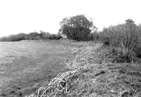
Greenbarrow – 31.3.2004. Looking South, past what is left of possible kerb, and slight ditch. Great Care Hill is just peeking out in background.
Image credit: Martin Bull
Greenbarrow – 31.3.2004. Looking South, past what is left of possible kerb, and slight ditch. Great Care Hill is just peeking out in background.
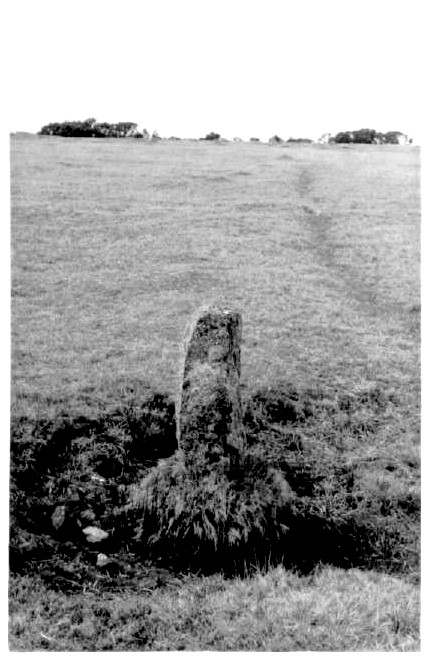
Pic 8 – Trehundreth Downs Menhir / markstone – 31.3.2004. From South east.

Trehundreth Downs Stone Setting / Row – 31.3.2004. Looking towards possible barrow on the west side.

Trehundreth Downs Stone Row – 31.3.2004. Sorry, not easy to photograph (yes, the stones are those dark bumps!) Note – another ‘landmark’ to look for when trying to spot the stone row is a small marker / boundary stone about 30 metres north of the row.

Colvannick Tor Stone Row – 31.3.2004. The final stone at the south end.

Colvannick Tor Stone Row – 31.3.2004. the renultimate stone at the south end before the long gap to the very final stone

Colvannick Tor Stone Row – 31.3.2004. The four main stones at the south end of the stone row (3 in foreground, and the final stone in the far background). Looking south east.

Colvannick Tor Stone Row – 31.3.2004. The stone at the north end of the row, looking west.

Colvannick Tor Stone Row – 31.3.2004. The north end of the stone row, looking up the alignment of the row (I think).

Pencarrow Rings Hill Slope Fort – 31.3.2004. In a negative style. The sign advetising the hillfort, with the ramparts in the far background at the road.

Pencarrow Rings Hill Slope Fort – 31.3.2004. The ramparts on the north west side.
Symonds Yat – 24.4.2004
The OS map shows three parallel lines of defences on the south side of the Symonds Yat Rock, and an extra bank at the west end. This would have attempted to cut the whole of Huntsham Hill off from the mainland, with the River Wye surrounding it on three sides.
They are situated on the west side of the road (B4432), just to the south of the entrance to the car park for people with disabilities. Three lines of banks and ditches are clearly visible (but not large), with the northern one being the largest. This one seems to straddle the road as well. This is not actually the high ground in the area, and the defences are slight, so this seems to be a relatively low-key attempt at any sort of ‘defence’.
The nearby Yat Rock is a major viewpoint in the area and is well worth a visit. Another excellent viewpoint exists just off the east side of the road, opposite the banks and ditches.
The Long Stone (Staunton) – 25.4.2004
This is a very impressive chunky stone, marred only by being so close to the road and thus taking on a bit of a novelty factor. It is quite literally 2 metres from the edge of the road, on the north side.
It must be more than 7ft tall because my 6’ 5” friend stood next to it and quite a lot of it went over his head. I’d say it must be close-ish to 8ft tall.
Harold’s Stones – 25.4.2004
First things first – these are ENORMOUS! After several trips in Cornwall (and other places) searching out the minor league stones and barrows, I’d almost forgotten what things like this looked like.
None of the posts on here actually said how big they are, and the only other report I had read also didn’t mention the height, and the pic I saw made them look distinctly human size. I hadn’t read the page in the TMA book before going – oops. However it actually made it better by not knowing what to expect. The largest stone (the cock stone as Jane says – or the ‘Cock Rock’ I reckon!) is actually about 14 ft tall and dwarfed us all.
The middle stone is strangely circular and looks a bit like a missile ready to fire. The third stone then looks a little out of place, as it is the smallest and most upright, is less rough and crumbly, and is more of a shape that you would find in a stone circle.
I didn’t actually visit the stone today, but did see it from a distance as it is visible from all the minor roads around (the best view is from Old Forge on the other side of the River Wye).
From a distance this stone looks like a thick beast with a rutted head. When I later saw pictures of it (see link below) this was dramatically confirmed.
King Arthur’s Cave – 24.4.2004
I don’t think I’ll try to explain much about how to get here because we came via a walk along the river and a detour up to the stunning views off the Seven Sisters Rocks. Personally I’d say that the easiest way is probably from a mini layby at SO548157, a hundred metres or so before you get to the bigger car park (circa SO548158) that is at the edge of the entrance to the Biblins Camp Site. From this layby head south down a track, past the old quarry on your left, and then you will come across several sets of caves on your left (opposite a lovely grassy field on your right). The caves range from large ones to tiny holes and possible rock shelters. Given a lack of information over which one exactly is ‘King Arthur’s Cave’, I can’t say for certain if the most impressive one is King Arthur’s Cave or not. Oh well; they were all pretty atmospheric anyway.

Stanton Drew – The Great Circle – 30.12.2003 – recumbent, and thin, stone on the east side with amazing round bowls in it. Looking across the south west part of the Great Circle

Stanton Drew – 30.12.2003 – four huge stones of the circle with the village in the far background.

Stanton Drew – The North East Circle – 30.12.2003 – two huge stones in the North East circle

Stanton Drew – The Avenues – 30.12.2003 – the stone avenue from the main circle down to the other two stones

Stanton Drew – The Great Circle – 30.12.2003 – the second stone in from the main entrance. A massive recumbant slab.

The Three Shires – 23.1.2004, from a difficult angle (over the wall)

The Three Shires – 23.1.2004, from the ditch at the side of the road

the ramparts of Little Solsbury Hill on a misty day – 23.1.2004

One of the lansdown barrows – 29.12.2003. My other pic came out even flatter!

the top of Tolborough Tor Cairn – 28.3.2004 – Looking north towards the Brown Willy area. Note – Catshole Long Cairn is in the distance, straight over the gorse bush (can’t really be made out in the pic though!).

Council Barrow – 28.3.2004 – From behind some abandoned farm machinery, towards tracks that go up and over the barrow! Taken from the north west side.
Castle Canyke Hill Fort – 28.3.2004 – South west section of the hill slope fort as it arcs around to the south

Stantonbury – 30.12.2003. Part of Wans dyke, on the north side of the hill.

Stantonbury – 30.12.2003. From the road on the north east side. The hill looks a bit like a beached whale.

Stantonbury – 30.12.2003. An entrance seems to partly survive on the north east corner of the top of the hill.

Piuc 35 – A possible for the ‘Chambered Stone Dwelling’ – 30.3.2004. This is the dwelling mentioned in the field notes, and the more I think about it, the more this is not the stone dwelling. I’ve included it here to show you what I saw, and to give any future visitors an idea of where it is.

Ackland’s Moor Cairns (North) – 30.3.2004. This is the cairn at SS13234478, with the quarry pit in the foreground.

Ackland’s Moor Standing Stone (West) – 30.3.2004.

Possible pic of the ‘Ackland’s Moor Hut Circle & Enclosure’ – 30.3.2004. Not easy to photograph! I was definately in the right area.

Pic 30 – a possible for the ‘Ackland’s Moor Cairn Stones’ – 30.3.2004. For want of a better name, the penis and scrotum stone, at it’s end.

a possible for the ‘Ackland’s Moor Cairn Stones’ – 30.3.2004. For want of a better name, the penis and scrotum stone is the one on the right!

a possible for the ‘Ackland’s Moor Cairn Stones’ – 30.3.2004.

Pic 27 – Ackland’s Moor Standing Stone (north) I think – 30.3.2004. At this point the recording of my pics was going astray.

Ackland’s Moor Standing Stone (south) I think, form a different angle, looking out to sea? – 30.3.2004. At this point the recording of my pics was going astray.

a possible for the ‘Beacon Hill Stones’ – 30.3.2004. This is more like likely to be the stone in question (compared to another pic I took in the area – unpublished) because it fits the description better and has stones propping it up.

South West Field Stone & Cairn – 30.3.2004 – I think I found this site. A small standing stone with a cairn behind it. Looking north.
Extract from English Heritage’s record of scheduled monuments, via the MAGIC site.
Please Note – this link takes you directly to a PDF document. You will need a PDF viewer such as Adobe Acrobat Reader to view it.
Extract from English Heritage’s record of scheduled monuments, via the MAGIC site.
Please Note – this link takes you directly to a PDF document. You will need a PDF viewer such as Adobe Acrobat Reader to view it.
Extract from English Heritage’s record of scheduled monuments, via the MAGIC site.
Please Note – this link takes you directly to a PDF document. You will need a PDF viewer such as Adobe Acrobat Reader to view it.
Extract from English Heritage’s record of scheduled monuments, via the MAGIC site.
Please Note – this link takes you directly to a PDF document. You will need a PDF viewer such as Adobe Acrobat Reader to view it.
Extract from English Heritage’s record of scheduled monuments, via the MAGIC site.
Please Note – this link takes you directly to a PDF document. You will need a PDF viewer such as Adobe Acrobat Reader to view it.
Extract from English Heritage’s record of scheduled monuments, via the MAGIC site.
Please Note – this link takes you directly to a PDF document. You will need a PDF viewer such as Adobe Acrobat Reader to view it.
Extract from English Heritage’s record of scheduled monuments, via the MAGIC site.
Please Note – this link takes you directly to a PDF document. You will need a PDF viewer such as Adobe Acrobat Reader to view it.
Extract from English Heritage’s record of scheduled monuments, via the MAGIC site.
Please Note – this link takes you directly to a PDF document. You will need a PDF viewer such as Adobe Acrobat Reader to view it.