Interesting pathways? Standing Stone’s Michael Botts ruminations on the long cairn.
moss
If you are interested in wells, then just before you get to the village of Duloe, take the right hand lane (to Herodsfoot) from St.Keyne, and along that lane you will come on a very pretty moss and fern laden well of St.Keyne’s. Robert Southey’s poem will explain the consequences of getting married should you drink from the well.
The Old Wife’s Well lies under the dreaded heading ‘Site of Disputed Antiquity’ and of course it is but its location next to a flint Mesolithic site and an old Roman road??? – See below for another explanation – gives it validity, and anyway it is a source of local water for those who have lived or passed this way over the moors, not forgetting the way marking, very probably prehistoric stones, that can be found a couple of miles on along this lonely stretch of moor and also of course the burial cists that can be found under the stone track way.
It is difficult to find the well though it is only a few yards from the road but buried inside the forestry trees. There is a forestry track way where you can park on the right just out of the village of Stape, walk along here if you want to see Mauley Cross. To find the well, turn left on the road towards the village and walk a few hundred metres along it, to your left you will see a faint path which will lead to the well. The well has it ‘clouties’ hanging on nearby trees, so does have visitors. Before the vast swathes of the forests were planted around the 1920s on the moors, this would have probably been farm land…… So maybe the spring of water with its unusual inscription may in fact be part of a much earlier prehistoric history…..
As the Roman Road/causeway does not appear on TMA here is the explanation for the Wheeldale Linear Monument being interpreted as a Neolithic boundary structure, and mentioned by Fitz..
en.wikipedia.org/wiki/Wade%27s_Causeway
“here are some objections to the interpretation of the structure as being a road at all, including the fact that several burial cists along the structure’s course protrude through its surface by up to 0.4m, highly unusual for a road surface. Since 1997, authorities including English Heritage have accepted the possibility that the structure may not be a road. Archaeological consultant Blaise Vyner suggested in 1997 that the structure may be the collapsed and heavily robbed remains of a Neolithic or Bronze Age boundary wall or dyke. There are other Neolithic remains on the North York Moors, including boundary dikes, although Knight et al. report that the later Neolithic is very poorly represented archaeologically in the North York Moors area] and neolithic use of the moors was likely very limited in extent. Bronze Age presence in the moors, including earthworks, is well represented generally in the archaeology of the area, and therefore is a more plausible origin. Evidence against the identification of the causeway as an early Neolithic structure includes the statement by Elgee in 1912 that the causeway had been identified as cutting across an earlier British earthwork just north of Julian Park, suggesting that it must post-date it. One possibility that could explain several of the anomalies in trying to definitively identify the site is the suggestion by Knight et al. that it was commonly observed practice in the area for dykes to be reused as track ways.
To account for the uncertainty regarding the structure’s original function, the term “Wheeldale Linear Monument” was introduced in the 2010s to refer to the structure. English Heritage in 2013 stated that the balance of opinion had swung to favour a prehistoric, rather than Roman, origin for the structure. As of 2013, the uncertainty regarding the monument’s purpose and origin is reflected by the information board at the end of the Wheeldale section of structure, where it meets the modern road. The original sign, pictured in 1991 states that the structure is a Roman road, whereas new signage installed in 1998 admits that the origin and purpose of the structure are unknown.”
Well to add to the story of the person in the ‘boat coffin’, Jacquetta Hawkes writing in her ‘Prehistoric Monuments’ tells a somewhat different story, perhaps I should say a more embroidered rendition, considering the only remains found in the coffin was part of a foot, with shoe/clothes, etc. But see Pastscape link below..
“which proved to cover a Bronze Age burial of an unusual kind. The excavators struck suddenly on an oaken timber near the base of the mound, and from it gushed gallons of water. This had been contained in, and was helping to preserve, a boat-shaped coffin with neatly fitting lid, which had contained a body extended full length, wearing clothes and shoes and with the head resting on a straw-stuffed pillow. Oak coffins are know elsewhere; what was unique at Loose Howe was the presence beside the coffin (itself carefully carved to suggest a craft) of a dug-out canoe, perhaps a ritual vessel, perhaps one which had been made for practical use”
Well according to Pastscape this other canoe, may have been in fact another coffin.....
There is a book of poems written by Jeremy Hooker, “The Soliloquies of a Chalk Giant”, in which our giant appears, rather sadly at times. The last verse on one of the poems is below...... As he is a disputed giant on TMA, legends will abound of course.
“The god is a graffito carved on the belly of the chalk,
his savage gesture subdued by the stuff of his creation.
He is taken up like a gaunt white doll by the round hills,
wrapped around by the long pale hair of the fields.”
But Jeremy Hooker went on to speculate about the naming of this giant, and to quote him, I have found something I wrote ages ago, his book was borrowed from the library some years back..
If as Hooker says, he comes from this time than he must be Helith – “In which district the god Helith was once worshipped” This comes form an old document, and is part of his legend. Helith, an iron age god who takes his name from Hercules. Romano-Britains would have adopted and changed the old roman god to fit their own religion.
Augustine’s mission in 601 AD seemed to have renamed him as Cerno El, the pagan saxons renaming him as Heil. But apparently during the saxon period he shared his valley with another god whose neophytes purified the waters that had long been sacred.
But to conclude, here is Hooker’s meaning for the words Helith....
“Helith; that is holy stone – or a corruption of Helios, maybe the sun. A sunstone, pediment in earth. The ground is dense with holy names; Elwood, Elston hill, Elwell, Yelcombe (y l cwm). Was there a standing stone on Elston Hill before Helith was fleshed out below the Trendle: Where beth they, beforen us weren? Make your enquiry of the dust, I make no enquiry there. Give me a living name”
Geographical facts and numbers of stones in the three stone circles, collected whilst following Daniel Gumb’s history...
The Hurlers consist of three rings of stones, they stand on the open moor one and a half miles west of Upton Cross, just west of Minions. The stone circles are set on a line north east, south west and if we work north to south the dimensions are as follows diameter 110ft with 13 standing stones, 135 ft with 17 standing stones and 105 ft with 9 standing stones. The rings can be studied carefully and it can be seen that each ring would have had many more stones at one time, probably between twenty five and thirty five each. The group lies on a route way between the rivers Lyhner and Fowey and are aligned with a number of monuments close by, the cairns on Caradon and stone rows on one axis and long toms cross and Rillaton barrow on the opposite axis. It has been confirmed that the stones had been placed in pits with stones packed around them. They had been hammered smooth and the chippings strewn over the interior. Little was found in the stone circles. The central circle contained an upright stone placed off centre and the northern circle had been paved with granite blocks. Between the central and southern circle lay another patch of paving and a small pit. To the south west, 120 metres away are two more standing stones. known as The Pipers, possibly the remains of another circular monument or an alignment running down to the river Fowey. It is highly likely that the circles were built over a lengthy time span and a single site might retain its significance for centuries. Perhaps the central circle was at the nucleus of a monument collection of different dates.
Taken from.... Daniel Gumb’s Country Deborah Bennett
Robin Fleming in her book ‘Britain after Rome 400 to 1070’ mentions that, this complex landscape of hillforts and Saxon royal palace was part of a ritual landscape. She goes on to say.....
“that Bede did not mention that the king’s hall and other major structures were erected in a straight line between the stone circle and the barrow and that the layout of the ‘modern’ seventh-century complex was thus determined by these ancient and enigmatic monuments”
The Saxon complex seems to have had a 7 tiered theatre, and pits filled with ox heads, evidence of ritual use. The use of earlier prehistoric monuments such as barrows for instance were often used by these later settlements to add prestige to families and the small kingships that abounded at this time.
Found the following verse sometime back and wrote about it, Iolo Morgannwg was obviously an interesting character but fought shy of truthfulness....
As the sun, so shy, speeds on to hide behind the western hills
I stand within this
Ancient circle with its rugged stones
Pointing to the sky
Like the digits on the clock of time -
The time that has refused to move,
As if the keeper of this heather hearth has gone to bed
Remembering not to lift
The fallen weights of Time and Space.
The first verse of one of Iolo Morgannwg’s poem, some would call him a fantasist who created an idea or vision of a Celtic Druidic order in the 18th century.
His first meeting of the bards was on Primrose Hill in London, where he had erected twelve stones called the Great Circle and a central altar stone known as the Maen Llog, this was in 1792. It is said of Iolo that he constructed an “elaborate mystical philosophy which he claimed represented a direct continuation of ancient Druidic practice. His use of laudanum may have contributed to this fabrication, though many of his writings fall between a small truth and a large imaginative myth that he wrote!
In 1795, a gorsedd meeting took place at the Pontypridd Rocking Stone, near Eglwysilam in Glamorgan. This was a huge slab of natural slate stone (the Maen Chwyf), and this stone became a meeting place, though the circles were yet to be put up.
The word gorsedd, which in Welsh means throne, but is also loosely used as a coming together of bards. Julian Cope in his book The Modern Antiquarian says of this rocking stone ‘that it stands high on the ground overlooking the confluence of the two great sacred rivers Rhodda and Taff,’ and that this gorsedd stone must have had great significance in prehistoric times. The stone is surrounded by two circles plus an avenue but the circles are not prehistoric, and it now sits in a pleasant landscape next to a small cottage hospital.
This is truly miscellaneous, stones that no longer exist. But just to the east of Bitton Barrow, in between two fields called Mickle Mead and Holm Mead there are several stones following a line just above the River Avon.
So to record them for posterity the grid refs for Oldmap Uk are 367552,168907.
Well they maybe stones from a stone circle given their site near the river (and the fact that Stanton Drew is not too far away), this part of the world has a lot of Roman history as well, situated under North Stoke, in the hills above with its large ‘spout’ of water by its church and of course the church in Bitton also supposedly a ‘heathen’ temple..
The present site of the stones (which must have been moved in the 19th C probably for the road) is I believe a sewage plant!
Map of stones..
maps.nls.uk/geo/explore/#zoom=16&lat=51.4175&lon=-2.4674&layers=6&b=1
Squinancywort (asperula Cynanchica)
“Every time a botanist journeyed from London to Bath, he was tempted to get down from his horse and climb Silbury, as Thomas Johnson had done in 1634, for in 1570 the Flemish botanist De l’Obel had written having been up the mound..this ‘acclivem cretaceam et arridam montem arte militari aggestum’(this steep chalky hill dry hill raised by military art) as he called it.... On Silbury he found a plant blossoming in July and August which seems to have been Asperula Cynanchica, which he called Anglica Saxifraga, the first record for Gt.Britain.
Squinancy is the quinsy,sore throat and this waxy--flowered little perennial of the downs made an astringent gargle”
Taken from The Englishman’s Flora by Geoffrey Grigson.
Note; Squinancywort is similer to sweet woodruff which you can find in woods, but I doubt Silbury still has Squinancy on its slope.
Sun Discs;
northstoke.blogspot.com/2008/02/lansdown-barrows-and-golden-disc.html
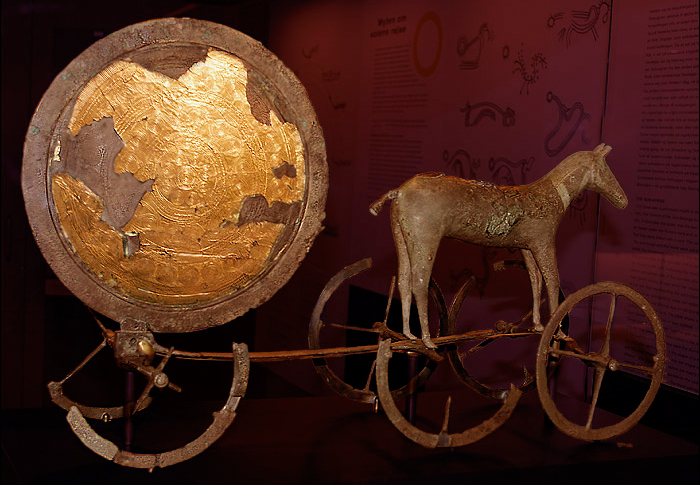
A few days ago someone who is writing a book on Lansdown race course asked me about the Bronze Age ‘sun disc’ that was found in one of the barrows. It was in fact gold over bronze (most of the gold having disappeared) and was in such a terrible state and in so many fragments that its reconstruction is a matter of drawing the complex pattern on paper, which both Rhiannon and Mike Aston have done.
Having delved through what little information there is, I was struck by the fact that the term ‘sun disc’ might be a misnomer for some of these artefacts. These Irish sun discs are buttonlike almost....
gutenberg.org/files/26880/26880-h/26880-h.htm#Page_62
There is a similar small gold disc found at Jug’s Grave also,
themodernantiquarian.com/site/7660/jugs_grave.html
a few miles from the Lansdown, here we are in Wessex kingdom land of course, where gold is occasionally found in the B/A barrows. So was the 6 inch Lansdown a bigger version of a sun disc, and are the smaller ones more like ornamentation for horses or people, And not to forget the Trundholm Sun-Chariot a gold/bronze depiction of a mare pulling the sun, the disc has a certain similarity to the Lansdown one...
This is a place I have never been to, and it looks like no one else has either. Its another Chevaux de Frise, though not the same as the ‘Bryn Cader Faner’ cairn which is so striking.
According to N.P.Figgis (Prehistoric Preseli) the method employed in building these treacherous out pointing stones might have been the result of an itinerant architect, be that as it may Castell Henllys, which is close to Carn Alw, has similar defence methods in its ditch, now covered by a later bank.
Carn Alw though situated at the back of Carn Meini if my map reading skills are right, is defended by “a wide chevaux de frise, incorporating set and naturally grounded stones in roughly three bands” on the easily accessible south-east side.”
Figgis goes on to speculate as to whether the elaborate entrance and boulder lined lane with a kink in its length has something to do with a stock enclosure, either for bulls or ponies, as the area defended is very small. Wild ponies still graze these moors, and they are very like the small ponies depicted on Iron Age coins......
The question as to whether the burial cairns had been used for ‘walker cairns’, or other purposes remain unanswered. But the following information does state that one of the cairns was excavated in the 19th century. It is also interesting about the extensive settlement pattern below the summit cairns.....
“Carneddau Estate – Moel Faban,
prehistoric houses, paddocks and fields;
The rounded hump of Moel Faban (“moel” in Welsh means bare or bald hill in this context)
dominates the village of Bethesda and on both its east and west sides is extensive evidence of prehistoric settlement.
The east side was surveyed by RCAHM (Wales) for part one of the Caernarfonshire Inventory published in the 1950s but further evidence of prehistoric land use has become more apparent recently, and a new survey as part of a more long-term and comprehensive survey of the hill was commissioned.
The summit has a series of Bronze Age cairns, one of which was excavated in the nineteenth-century from which a collared urn of the middle Bronze Age was removed (now in the British Museum).There is no clear relationship at all but it is thought that some of the dwellings within the field-system could also have Bronze Age origins, but by analogy with similar sites they would normally be thought later. None has been excavated so this earlier date has by no means been confirmed. As well as concrete evidence of cultivation, or at least controlled pasturage, this immediate area has other tantalising evidence of prehistoric life.
This includes Bezant Lowe called the “arrow stone”, a massive boulder on the top of which is extensive evidence of the sharpening of blades. There is to the east of the hill fairly conclusive evidence of burnt mounds situated by the stream of the Ffryddlas where food was cooked by dropping heated stones into small constructed pools, a technique that has been proved to work, as anyone watching “Time Team” will know!”
The ‘Arrow Stone’ on Rockartuk
rockartuk.fotopic.net/c1224904.html
References:
RCAHM(W) 1956 Carnarvonshire vol 1
Bezant Lowe,W. 1927 In the Heart of Northern Wales pp53 – 56
Griffiths,W.E.1959 Arch. Camb 101, pp44
The plundering of megalithic tombs by vikings,
“Amlaibh, Imhar and Auisle (Audgisl) three chieftains of the gaill; and Lorcan, son of Cathal, King of Meath, plundered the land of Flann (North Brega).
The cave of Achadh-Aldai (Newgrange); the cave of Cnoghba (Knowth); the cave of the grave of Bodan over Dubadh (Dowth); and the cave of the wife of Gobhan at Drochat-atha (Drogheda) were broken and plundered by these same gaill.”
Taken from the Annals of Ulster
The viking raids on the great megalithic tombs of the Boyne valley in 863; by Olaf (Amlaibh) Ivar (Imhar) and Audgisl, probably carried out because after all the monastic raids that had been undertaken over the previous years, ‘treasure’ was by now getting hard to find.
Is it true you may ask yourself, well it was recorded, and though there is some dispute about Newgrange (according to Gordon), it is a fascinating fact. The book I found this information from goes on to speculate, that one of the ‘gaills’ Ivar might have been the son of Ragnar Lothbrok, who spent three days in Maes Knowe because of a storm raging violently outside, and left the following scrawled on the wall...
This mound was raised before Ragnar Lothbrok’s...
His sons were brave, smooth-hide men though they were...
It was long ago that a great treasure was hidden here...
Happy is he that might find the great treasure...
Be that as it may, I expect there was’nt much treasure in the great tombs of the Boyne valley either.
Information gleaned from ‘The Fury of the Northmen’ by John Marsden.
Although the Kenward stone is considered natural there is another story attributed to it that may give it a prehistoric link. John Chandler has written about it in this Wiltshire Council link....
wiltshire.gov.uk/community/getconcise.php?id=60
which states that the stone had been removed from a field in which other stones lay...
“about 1890, he reported, he had been told by two of Chute’s oldest inhabitants that the stone had been moved there from a field where there were other big stones, some of which had been buried out of the way. But nobody by 1924 could remember where, and so part at least of the pseudo-Kenward stone’s mystery remains.”
This really is miscellaneous, but today someone sent me a photograph of a stone circle on the cliff top at Trefin Cove. It is probably a fairly modern one (though it looks real) but there is no literature for it. But some weeks ago, someone mentioned a circle in this area, so if you’re on your way to Carreg Samson, stop off at Trefin Cove and look up to the cliffs, some information would be interesting as well.
a photo; geograph.org.uk/photo/1332814
Prehistoric artwork has been discovered by an amateur archaeologist at a Perthshire mountain range.
The ancient carvings were discovered by rock art enthusiast George Currie at Ben Lawers, near Loch Tay.
Mr Currie discovered a piece of rock which has more than 90 cup marks, which are circular depressions in the stone.
Some of the cups have rings around them and a number of linear grooves can also be seen, with some still showing the individual blows of craftsmens’ tools.
Similar discoveries have been made in the area, but it is unusual to find so many markings on the one stone.
The purpose of the artworks are still unknown.
Derek Alexander, archaeologist for the National Trust for Scotland, said: “This is an exciting find as it shows that there remains undiscovered prehistoric rock art to be found in the Scottish hills.
“More surprising are the quantity and variety of the symbols displayed on this boulder.
“Through both targeted research by professional archaeologists and the work of dedicated amateurs like George Currie we now know that Ben Lawers forms one of the major concentrations of cup and ring marks in the Highlands, which suggests it was a very significant landscape in prehistory.”
Well as people find it difficult to get to, some information from Jody Lewis’s ‘The Neolithic of Northern Somerset‘
She says that when she surveyed it in 1998 that they found over 30 stones, some standing, some recumbent, the stone following the long axis e/w.
Stones remaining seem to be a section of passage at the east end, a chamber opening off and a chamber at the end, and that around the end chamber, are many stones that have the appearance of fallen capstones. It looks like she is saying that quarrying took place as well, and stones put back in are field clearance......
four chestnut trees on the mound and a lot scrub around, so unfriendly farmers, and large trees on top!
There is a whole cluster of longbarrows in this area, ruined by farming mostly...
Big Tree; Orchardleigh; Giants Grave; Barrow Hill; Fromefield, and slightly further afield Brays Down, and Stoney Littleton which of course is the best preserved of the whole group here.
Several years later and wandering through the Welsh saint book, and my stone just might be part of a stone circle and not disputed ;)...
The church was named after Rhian – 5th or 6th century, a follower of St.David. He founded a church here, “probably a wattle and daub building behind an earth wall” Breverton goes on to say..“In Llanrian parish, not far from Tregynon, is Llain y Sibedau (Place of Whispers) a ruined stone circle”
The Book of Welsh Saints.
1849 – Llanrian
“Near the church are some Druidical remains, consisting of many large stones, most of them now broken: they were formerly erect, and, in their arrangement and general appearance, formed in miniature, according to Mr. Fenton, a tolerably correct representation of Stonehenge”.
From: ‘Llanrhychwyn – Llansawel’, A Topographical Dictionary of Wales (1849), pp. 85-98. URL: british-history.ac.uk/report.aspx?compid=47856
A book by Adrian Arbib on
Solsbury Hill
Chronicle of a Road Protest
Foreword by George Monbiot and Paul Kingsnorth
Taken from the Cornish Ancient Site....
This is a reconstructed barrow in a class of monuments called entrance graves or chambered tombs. It consists of a circular kerb of stones with an entrance; Brane barrow is similar.
Approximate Neolithic dating 3000-2500 bc and has a diameter of 4.95 m and a height of 1.5.m approximately. It was excavated in 1984, when a primary deposit in a pot was discovered, it also had, interestingly enough, turf and topsoil in the chamber – ritual deposits?
Entrance passage was deliberately positioned to face the midwinter solstice sunrise (same as Brane Barrow).
Again Nicholas Thomas....but he is good on description.
“Battlesbury is irregular in shape, its defences following the contours of the hill. Its triple ramparts, double on the S.E. enclose 23.1/2 acres. There are entrances with outworks N.E. and N.W, Pits found within the fortifications contained late I/A pottery, the hub of a chariot wheel, an iron carpenter’s saw and a latch-lifter for a hut door. These indicate permanent occupation and a date in the 1st C. That its inhabitants came to a violent end is indicated by the discovery of many graves containing men, women and children outside the N.W. entrance...It is not known whether roman legions put people to the sword, or whether this was the result of inter-tribal warfare before the roman conquest”.
A Guide to Prehistoric England.
According To Nicholas Thomas (A guide to Prehistoric England) Rhiannon..he says this about Scratchbury;
“This superbly placed hillfort, looking across at Battlebury Camp, encloses 37 acres within a bank and ditch with a counterscarp bank. Its irregular four-sided shape follows the contour of a steep hill. There are two entrances on the E side, and possibly a third on the N.W.. Remains of a much smaller inner earthwork of much smaller size can be seen. This resembles the earlier enclosure at Yarnbury and has recently been dated 250 b.c...He goes on to say that there is a romano-british or later ditch, running E/W, and turning S, sharply at the SW corner of the hill-fort overlies the I/A eartworks. Main ramp[art must have been built in the 1st C. BC”
The following extract taken from Paul Ashbee’s “Barrows, Cairns and a few imposters” highlights an interesting longbarrow with a mortuary enclosure. There seemed to be no evidence of any timber remains under the barrow itself amongst the flints when it was excavated, but that ‘the flints remained in a roughly ridged form’.
The collapse of the barrow on itself, timbers decaying over time, had forced out ‘stacked long bones’; skulls were also found in an ‘exploded’ condition. The barrows length was 135 feet.
“What did barrows look like when first raised? At Fussell’s Lodge long barrow, near Salisbury, the discovery of post-holes in a lengthy, trapezoidal structure showed that initially there had been a structure resembling a Neolithic long house of the type found widely on the Continent. Subsequent long barrow excavations showed that this formula was widely followed. These surrogate long houses contained deposits of human bone that were added to and subtracted from, for more than a millennium, and rites pertaining to ancestors and fertility were no doubt performed. Long barrows, the long houses of the dead, should be regarded as shrines rather than mausolea.”
britarch.ac.uk/ba/ba32/Ba32feat.html
The ‘long houses of the dead’ are explored by Richard Bradley in his book ‘The Significance of Monuments’.
Further to Rhiannon’s notes, (reference later) Garn Turne is one of three megaliths clustered around the hamlet of Colston, and apparently seem to be the end of the monuments that delineate the Myndd Preseli group....
It is an enormous capstone Nash says, one of the largest in Britain(weighing more than 60 tons,) now collapsed.
It had a ‘v’ shaped forecourt similar to Pentre Ifan and Irish court tombs, facing north-east toward the large rocky outcrop. Apparently it has a large, pointed sandstone conglomerate block within the centre of the forecourt (think Pentre Ifan started with one singular stone).
It’s ‘hidden’ or at least merges into the stony outcrop that surrounds it, a feature of a lot of the cromlechs round here, and of course the siting near to a distinctive outcrop; the ‘gorsedd’ maybe of Julian Cope fame...
ref; Neolithic Sites of Cards, Carms, and Pembs. by Geo.Children and Geo. Nash
The “Kyber Pass”.. Close to Clifton Suspension Bridge, 3 promontories have been fortified by earthworks, these three camps are within 800 yards of each other. Apparently all were identical in design, which could point to them being contemporary. Dated to 300bc to 100 ad, some use in medieval period.
Stokeleigh Camp faces Borough Walls across a short valley. Two bank and ditches, with additional banks on the N.W, and also at the S.E. overlooking Nightingal Valley. Entrance close to S.W. corner, area enclosed about 6 acres. Taken from....
Guide To Prehistoric England – Nicholas Thomas
Reverend Skinner had a theory that the Wansdyke might have been extended in this direction.
Tunley Cromlech destroyed. Identified by Skinner as a capstone with two supporting stones, but was already being broken up by 1812 for road material. Skinner says;
“there was a cromlech on the highest point to the east of Tunley Camp”
Jodie Lewis (Monuments Ritual and Regionality) Neolithic of north Somerset says, that it could either have been the remains of a Cotwold Severn barrow or a simple portal dolmen.
A Poem addressed to the destructive process of the new road being built through Tara’s historic landscape. Sacred to prehistory and to the history of Ireland, for this a few protestors will go to prison, people will write letters in vain to newspapers, and politicians will procrastinate and write their lies...... it is wise to remember that progress has a heavy boot to wield and often hasty and ill-concieved laws to underwrite the handiwork of the bully and developer...... the poem is taken from the Save Tara site.
Song to Progress
no swan , no snail must stop this dash
to tear around with wads of cash
and get at speed from A to B
and not to Dawdle pointlessly
So – move Along ! – wont it be Grand !
when Ireland’s just like Legoland
my work will only be Complete
when Boyne to Liffey’s all Concrete
and Shoefayre stands where Fianna fell
and Leisureworld – and Next as well
IKEA – if we’re really lucky
and drive-in Chicken from Kentucky
THIS is what we want to see
not grass and trees and history
but modern stuff – and this and that
and things on which we can put VAT
and if you want to get more slim
why walk ? – just buy a Multigym
When we’re encased in cans of steel
both hands attached to steering wheel
and eyes fixed on the road ahead -
we may as well be effing Dead
this stretch of road – built over bones
is one of many thousand clones
did we just pass the Lia Fail ...?
it could be anywhere at all
just sit like this an hour or two
as if you’ve nothing else to do
and work and work all day and then
stay sober and drive back again
a quarter million cars a day
is JUst what Dublin needs I say !
aMAZing what they get to pay
to park the things – we’re making hay !
cos there’ll be car parks to be built
and lots of pockets to be filled
there’ll be no end to means and ends
cos its so nice to have good friends
there is a railway – but you see
it closed in nineteen sixty three
it could be opened up again
but that somehow doesnt seem to happen
Mad Suibhne sitting in his tree
is keeping feathered company
he watches as the human race
is drifting loose from sense of place
and capsulated in a car
of who and where and what we are
so every weekday without fail
we slave to buy a better jail
or hang on to the one we have
by hook and crook and tooth and nail
and so far is now the space
and so far have we come apart
we even think to cut the Heart
“Progress”
?
though feathered Suibhne looks absurd
he doubts if it’s the proper word
marcellavee 1/08/07
The following taken from George Witt’s Archaeological Handbook of the County of Gloucester 1882; he places it under the name of Littleton Drew Barrow.
“This was first noticed by John Aubrey in his MS., “Monumenta Britannica,” in the seventeenth century; it was called “Lugbury.” It lies in the parish of Nettleton, but close to Littleton Drew, in Wiltshire, just outside the boundary of our county. •It measures 180 feet in length, and 90 feet in breadth, its greatest elevation being six feet. Its direction is nearly due east and west. There are three stones at the east end, on the slope of the barrow, thirty feet from its base; the two uprights are •six feet six inches apart, two feet thick, and four feet wide; one is •six feet six inches high, the other •five feet six inches. Resting on the mound and leaning againstº the uprights is a large stone, •twelve feet long, six feet wide, and two feet thick. A cistern was discovered •about sixty feet from the east end, containing one skeleton. Another cistern was found on the south side. Three other cisterns were also found, •about ten feet long, four feet wide, and two feet deep, formed of rough stone. The total number of skeletons found numbered twenty-six. Several flint flakes were also discovered. ”
“There seem to be few genuine traditions attached to the Horse, for its ‘traditional’ attribution to King Alfred is almost certainly due to Francis Wise in 1738 and is not mentioned by Baskerville or Defoe”
Can’t let that pass, the person who wrote it had obviously not read Jacquetta Hawkes on the subject or H.J.Massingham – two favourite books, if you want to read about the emotional love affair people have with their English countryside ;) look no further than early 20th century literature.
The scouring ceremony is first mentioned by Aubrey and the best early record dates from 1677 when Baskerville wrote;-
“Some that dwell hereabouts have an obligation upon their hands to repair and cleanse this Lande marke, or else in time it may turn green like the rest of the hill and be forgotten”
The Uffington White Horse sired nearly every other 18th century chalk horse in the district!
He holds within his image, the beautiful celtic curvilinear design to be found on the horse furnishings around this area, he can be called a Saxon horse because of association with King Alfred and white horses, and of course he belongs to St.George and his dragon. His various mythical and magical guises link him to gods and harvest ceremonies....
Wayland Smithy is a place that has a haunting atmosphere, and as I am reading a Peter Please book at the moment, he is a ‘wayfaring soul’ of Bath much given to walking the Wiltshire countryside,I thought it would be nice to recommend his book; “The Chronicles of the White Horse”, written for children and adults it is a good book and the story culminates at Wayland’s Smithy...
In the following quote he invokes the bloodied hooves of the horse pounding between the standing stones, calling the dead and all things that have ended back into the barrow....
“I was at the door of the manger, the horseshoe chamber of Waylands. Not a grave, but a door,
a passage between two worlds; a spirit cavern for the dead and all that is dying....
and on a happier note;
“I heard the bells ringing in Wayland’s Smithy. I heard the larks above White Horse Hill.I saw the flowers opening. I saw the barley growing. I saw the lambs in the meadows. I heard the earth singing. And even when the last of the light had faded to a pinprick in the sky, and the last of the stars had disappeared.....
Myself when I wrote about it found it an utterly peaceful place but I expect it was because there were no people around – dead or alive ;)
“Neolithic Dew-ponds and Cattleways.” The brothers, Arthur and John Hubbard, wrote this lovely book, though its facts are slightly on the wild side, at the beginning of the last century, they diligently recorded the cattleways and dewponds around such places as Cissbury, Chanctonbury and Maiden castle hill forts. Wolf platforms; Maybe they got it wrong, but wolves, can you not see them, like great lions guarding the gates of Martinsell hillfort, really does send the imagination racing.
“The month which we now call January our Saxon ancestors called wolf-monat, to wit, wolf-moneth, because people are wont always in that month to be in more danger to be devoured of wolves, than in any other season of the year; for that, through the extremity of cold and snow, those ravenous creatures could not find of other beasts sufficient to feast upon”
Richard Verstegan
“Restitution of Decayed Intelligence in Antiquities 1673”
As you can be see, I didn’t find the cromlech, it is apparently but a few metres east of the rocky tor/outcrop on above photo which obviously gives the cromlech its significance according to Neolithic Sites of Pembs., Children & Nash). To get nearer the outcrop would have involved pushing through three lots of barbed wire plus climbing stone banks – something the Welsh farmers really get cross about!
Given its narrative within the landscape, (some cromlechs are hidden from view) this one, according to Children, its importance is linked with the rocky outcrop. It was not a visual concept, such as Carreg Samson maybe, but one constructed through ritual and symbolic knowledge of the landscape.
My interpretation of what he means by this, is that the shape of the outcrop is similar to the shape of a burial mound. Similar tor like shapes are found on the Preseli mountains – natural places being seen as the burial stones of long dead ancestors.
Neolithic mine shafts; to add to Rhiannon’s post, my book says there is a line of 39 shafts to be seen outside the south entrance of the fort. Some of the shafts go down 40 feet through the chalk, cutting through 6 or 7 seams of flints, with galleries radiating horizontally from the main shaft. Apparently there were two burials down there (one maybe accidental fall), no serpents though.
Iron age;60 acres roughly egg shaped, with two banks, and ditches, 250 bc. In its first form the chalk rampart stood 15 feet high and faced with vertical timbers, also had tie beams as well. The ditch, separated by a berm, was 10 ft deep into the chalk and about 25 feet across.
Fell into decay after 200 years, and was ploughed in the roman period, with the iron age ‘celtic’ fields in and around the fort. Then refortified for a short time at the end of the roman period against the Saxons this time, they won the day of course because there are saxon burial mounds on the Chanctonbury Ring Fort.
A guide to Prehistoric England Nicholas Thomas;
According to Nicholas Thomas – A Guide to Prehistoric England, this is a hill-slope fort and boundary ditch. He goes on to say that it is interesting because it is the only example in Wessex of this type. He also says its less defensive more to do with the herding of cattle, similar to ones found in Cornwall, Devon and South Wales. Date approximately 2nd-1st Century bc.
Two main earthworks – outer one, kidney shaped enclosing 12 acres, and an inner one roughly circular, but not concentric with the outer one, 2.1/2 acres.
A series of ditches radiate out from the Rings, could be late B/A but more likely iron age, being a ‘celtic’ field system, apparently the west ditch is probably the track down to the river for watering the cattle presumably...
The earthworks enclose about 15 acres. Two lines of ramparts on all sides except the north, which is protected by the river Frome and only has one (though two ditches). Original entrance through the east inner rampart, close to the mouth of the railway tunnel (quoting here from 1960’s book). Its one of those interesting hillforts that has timber revetments on the inner rampart, which is built of chalk and has a berm between it and the ditch. Probably 13 foot high, with a corresponding depth for the ditch. This work carried out 3rd century BC (maybe contemporary with Maiden Castle).
Then just before the roman conquest an outer ditch and bank was added, and the inner bank widened and heightened, AND a limestone parapet was built on the crest.
There is a story waiting to be written here.... apparently, according to the book, those responsible for this reconstruction were the Durotriges tribe who had seized Maiden Castle. Poundbury was important because it overlooked a ford across the river.
ref;A Guide to Prehistoric England – Nicholas Thomas- Batsford 1960.
A hillfort and a Roman signal tower?. Triangular in plan, its defences encloses 4 and half acres. On the N.S. and E. the earthworks comprise 2 banks with a ditch between them. At the S.E. level ground has caused the building of four ramparts with ditches outside them.
Maybe Roman bit; At the S.W. earthworks have been altered at some later stage so that an almost square earthwork has been constructed in the angle of the inner bank.
Within the hill-fort to S.E. are a group of about 9 circular depressions could represent site of huts B/A? south west of them is the mound of a bronze age bowl barrow.. Presumed Date; 250-50 bc.
Taken from A Guide to Prehistoric England – Nicholas Thomas 1960.
The following information is taken from Jodie Lewis – Monuments... The Neolithic of Northern Somerset..
3 circles, 2 avenues, a cove and a henge, with of course the geo-phys’d timber circles. Great stone circle has a dia; of 112.2.m and has 26 stones, the great avenue is 49 m long and 10.4.m wide. It could well be that the timber, stone and earth phases are contemporary, with the inner sacred centre of timbers (either in situ/or rotted) being the focus round which the stone circle and the henge (for viewing) were viewed. The open/closed nature of the central timber structure could be augmented with hurdles/planks for hiding rituals. But of course timber and stone periods might be different, the stone circle just acknowledging the sanctity of the older timber circles
North-east circle is 44 m to the n/e and has 8 very large stones, the largest in the complex, diameter of the circle is 29.6.m. One of the things to be noticed about these stones, no female/male typology, just large square blocks of stone. Leading from this circle is the n/e avenue with 7 stones. Apparently in the centre of this circle were 4 anomalies (maybe pits) sharing an alignment as the four pairs of stones that are the circle, but these circles had orchards around them so therefore tree remains cannot be ruled out.
The South west circle is recorded in 1881 as having some of its stones removed for the fencing round an orchard, so presumably stones have been moved around. It lies 137,2 m s/w of the great circle, has a dia. of 44.2m and is comprised of 12 stones, and Jodie Lewis goes on to say stones have almost certainly been moved around. Again geophysics noted 3 concentric rings of pits within this circle, so again presumably another timber circle within the bounds of a stone circle.
Note; this is written down, not just for anyone reading it but for those two young men sheltering from the cold wind behind a stone (one playing some pan pipes) when I was there last autumn and when they asked for an explanation – did my best at the time but did’nt have the book...
web.arch.ox.ac.uk/archives/underhill/viewarchiveslide.php?imageID=26&albumID=1 map plan in the Underhill Archives showing the Avenue
As a note; Stanton Drew circles do not seem to relate to any outstanding landscape feature, such as Maes Knoll, but are focussed towards the river Chew, Jodie Lewis makes the point that at certain times of the year, due to flooding, the river turns red from the clay and soil leaching into the river., this would give it a significance as a meeting place (there is lithic scatter found near the site). This river also joins the River Avon further down at Keynsham were ammonites are found, such as the one at Stoney Littleton.
Part of the henge can still be seen in the foreground of Morfe’s photo;
Well, according to this link, sacredsites.com/europe/england/cerne_giant.html.
If you take a sightline/alignment on May Day you should see the sun coming up;
to quote; “a sightline taken up the giant’s penis on May Day points directly at the sun as it rises over the crest of the hill”
So to verify this fact if anyone is around at dawn on May Day next year – please check..
All these eight barrows were investigated by the Reverend John Skinner in 1815, and all barrows produced one or more cremations. Some of these contained Early Bronze age urns and were covered with stone slabs (similar to Lansdown barrows cemetery). Three barrows had bronze daggers, one in a wooden sheaf. One barrow contained a rich burial which included beads and other objects of amber (maybe faience) and a miniature incense cup. There are a further two, much larger barrows, located north of the main cemetery.
Taken from;
British Barrows (A Matter of Life and Death) by Ann Woodward.
Freezing Hill, took some photos the other day of the lynchets that lie to the east and south of this maybe defended enclosure but no inner bank It is mentioned as a hillfort in Iron Age southern map, (1960) but not scheduled on Magic..
The barrow is at ST722.715. There seems to be a pattern of settlement around these forts/enclosures that needs to be explored. Its on private land, with lots of frisky bullocks around at the moment.
Edit;This site, is in many ways similar to Hinton Hillfort. A promontory hillfort, but in this instance guarding two valleys down from the Cotswold; a distinctive territorial barrier also perhaps. As Wick burial chamber is not too faraway, neolithic finds round this area would be expected (Rhiannon’s post).
Freorig = cold chill,(freosan – freezing) Anglo saxon.
Should anyone be in the area; a standing stone was recorded at Priddy close to the wall of St.Lawrence Church at ST 528513 standing 0.7 m above ground, (much weathered) also stones at ST510524 and SO595238. There is a tumulus nearby, just off Nine Barrows Lane.
Proceedings of Somerset Arch. Soc; Vol; 1984
Countering Goff’s slightly dismissive impression of the Chalice Well it does indeed have a small history. It is a major spring and in olden times would have served the settlement on Glastonbury Tor and the later abbey. A small excavation in 1961, which had to go pretty deep down because of silting, found flint and roman pottery. Also nearby the remains of a yew tree stump, bringing to mind the pagan reverence for a “sacred tree”, and yew trees have been found growing by the roman temple site at Pagan Hill nearby on the Mendips.
Today when you look down at the well you are looking through a hole of the roof of the old medieval wellhouse, which just shows how much it has silted up.
Taken from; Glastonbury, Myth & Archaeology – P.Ratz and Lorna Watts
St.Non’sWell, Pelynt.. directions
From Pelynt, take either minor road east down a steep hill to Watergate. Turn left on the road to Duloe. Before crossing the bridge over the West Looe River, bear left up a steep hill road signed “Hobb Park, at the top of the hill park at the cattle grid. The well is signed in the first field on the left. Go through the gate and turn left. After three minute walk you can see the well
Taken from Celtic Saints, Passionate Wanderers, Elizabeth Rees.
1967 Excavation by Geoffrey Wainwright of I/A hillfort on Bathamption Down.
80+ acres univallate fort, plus its relation to a field system was examined. Conclusions were that this was an early hillfort and was probably used as a stock enclosure... The ramparts were small and probably non-defensive, and the banks of the field system overlay the fort banks.
Reading everyones field notes, and if ones speculates, the stone circle would most probably be on the north side near to the river and facing Solsbury Hill, with the avenue(if it existed) leading down to the river. A bit like the missing stones on the other side of Bath, near to the river and facing Kelston Hill.....
This site is an important prehistoric settlement, in the sense that it is always mentioned in books on prehistory. It features in the landscape as a small twin-peaked saddled rocky outcrop, set about a mile back from the sea.
Two periods are archaeologically defined, the later iron age settlement is a rectangular enclosure, measuring 100m x 25 metres. Two, possible third, neolithic houses have been found placed centrally within the ramparts. The area around the settlement site shows evidence of Mesolithic activity, and there is probably continuous occupancy of this area of 4000 years. One of the huts had been burnt which maybe implies ritual burning on abandonment.
Hav’nt explored its interior, due to exhaustion from long walks!, but will do so this year. Also worth noting that the burial tombs of Carn Llidi and Coetan Arthur may belong to these people.
information taken from Geo.Nash and Geo.Children- Neolithic Sites.....Pembs, Cards, Carms.
Lugbury has as the first syllable the name of a celtic god, Lugh or Lugus found mostly in Gaul but also in Britain, its Welsh equivalent is Lleu, and the land round here would probably have been Old Welsh country. Strange therefore, that two kilometres from the longbarrow should there be but the temple site of Nettleton Shrub, a romano-british shrine of several periods. The earliest being an early native round enclosure or temple. The dedications found at this site refers to Diana and her hound, Mercury and Rosmerta and Apollo Cunomaglus (the hound god)..... As Sulis was coupled with Minerva at Bath, Lugus as a celtic god was probably coupled with the roman Mercury. So does that mean that this longbarrow has carried the name down through the centuries, or has it been named by antiquarians? 28/7/06 to answer my own question, it seems to be called Lockstone on the 18th map of Andrew and Dury
E/W orientated was originally about 190 feet long and 90 feet wide, there are two small burial chambers, one on the north side, the other one visible on the south, maybe a false entrance on the east end. East and west end have only been recently destroyed (this statement made back in the 1960s.) Apparently 20 burials were found in the chambers and evidence from the bones suggest that it was used by one family.
Taken from A Guide to Prehistoric England – Nicholas Thomas.
The Hubba Low story may have got a bit mangled with the history of Chippenham and Alfred.. The Dane leader Guthrun had camped at Chippenham, 878AD, after he had defeated the saxons. Alfred eventually trounced him at Edington, and Guthrun was baptised into the faith and stopped harassing Wessex; Guthrum finally settled in East Anglia. Hubba, another Danish leader at this time, was defeated and killed in Devon at Kenwith castle by Odun.
Well here’s another story from Mrs.Clifford, Rhiannon, she could do sums as well..
She estimated that the Rodmarton l/b contained at least 5000 tons and writes
“The stones in the body of the cairn are placed with some care, not thrown in haphazardly. Not more than 20 men could do this at one time. This would employ 20 men placing, 20 men carrying, 40 men digging, and 20 directors (you can see its all male) and those engaged on ancillary activities – a total of 100. The 40 men digging won half a ton of stone a day,250 working days would be needed to provide 5000 tons, or one year with stoppages for weather, festivals, rest etc, and another year for preparation of site and erection of megaliths which would involve continuous employment of 100 men for two years”.....
not sure how she worked that one out, but the Glyn Daniels book I have taken it from,” Megalithic Builders of Western Europe”, shows Rodmarton as a Portal tomb, I suppose she is the one to blame for the destruction of the portal opening. Avening down the road was also a portal tomb. Its a stylistic difference – two opposing vaguely K shaped stones making the entrance....
The holy well at St.Madron is one of Cornwall’s oldest and most famous wells. St.Madern, of whom nothing is known may have been unique to this area, though apparently it has been a local surname. Madron church is an ancient church with a pre-christian standing stone now in the church, it was re-used in the 6th/7th C to mark a christian burial
St.Madern’s well is a mile north of the church, it is set in a grove of sallows and bubbles up through marshy ground.
Hung on the branches are hundreds of clouties and strips of cloth; these are symbolic prayers for healing or in gratitude of a cure. The chapel is 75 metres along the track, foundations of a 12th C building with a granite altar and a baptismal basin in its n/w corner. During the 17th century a great thorn tree’s branches formed a leafy roof over the ruined chapel, and the people used turf to repair a green bank by the altar which they called St.Madern’s Bed, and which, of course, sick people lay on and were cured......
Above taken (almost verbatim) from Elizabeth Rees – Celtic Saints in their Landscape.
1-50 of 62 miscellaneous postsNext page