
Low sunlight strikes Victoria Tower and the earthworks at Castle Hill.
Image credit: Andy H
Low sunlight strikes Victoria Tower and the earthworks at Castle Hill.

Castle Hill from the nearby fields off Ashes Lane.


Castle Hill – The Dragon Andy The Golden Cradle

The Cock Crowing Stone (not ‘Growing’ as some people have misread it) stands near the roadside, below West Nab on Meltham Moor. It’s impossible to miss due to having it’s name painted on in large white letters!
I’ve got no real further information regarding it’s provenance, folklore or otherwise. I’d only heard of it before, as when I found it quite by accident, I thought, “ah, there it is!“.
It’s name would suggest some kind of sunrise significance. It wouldn’t relate to any alignment on West Nab, so something else must be afoot.
If anyone has any further info, I’d love to see it. Maybe Mr Bennett can help on this one?
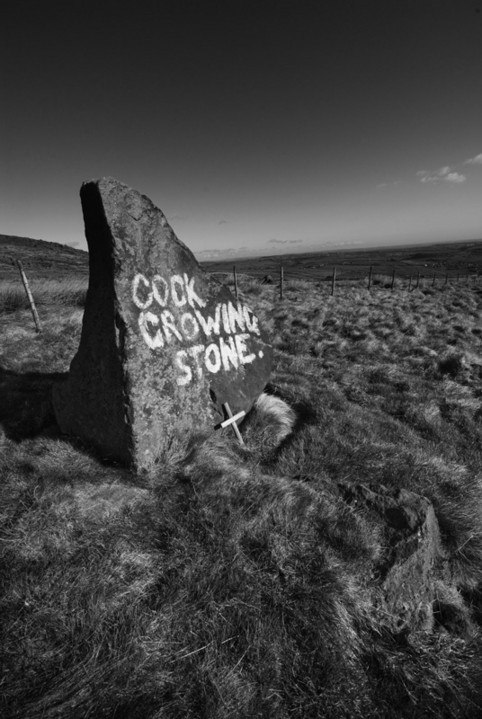
The Cock Crowing Stone on Meltham Moor.
According to Dr Bill Bevan’s report for Moors for the Future, Carl Wark is thought to have been mainly for ceremonial use. The wall built to block the view across Hope Valley to Mam Tor.
Stuart Piggot thought the wall to be similar to those at Dark Ages forts in Scotland.

Carl Wark from Higger Tor at sunrise. Mist clings to Burbage Brook.


Carl Wark from Higger Tor on a morning when Hathersage Moor looked more like arctic tundra than the Peaks. Even the sunrise didn’t make an appearance.

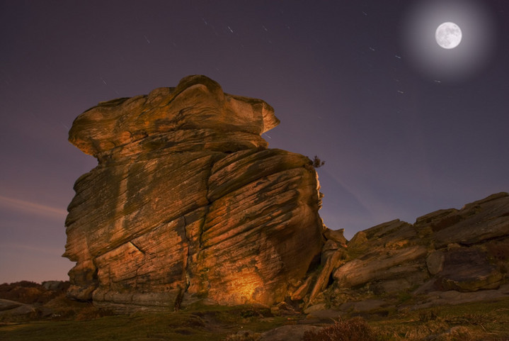
I have developed a bit of a fascination with Mother Cap recently!
Considering the history of Hathersage Moor and it’s conspicuous positioning, I thought that a bit of research may be called for. I came across a piece of information (probably StuBob’s notes) that suggests that Mother Cap may have been used as a marker for much of the prehistoric activity in the surrounding hills and was possibly illuminated by fire at night.
This caught my imagination and I thought it may be fun to try to recreate how the massive outcrop may have looked by firelight (of course not wanting to set half of the moor on fire, I used a 5 million candle power torch). So on Tuesday night, I found myself trudging up the lower slopes of Over Owler Tor by the light of a brilliant full moon. Over Owler is an odd place at the best of times, a bit of a geologist’s playground with rocks worn into all manner of strange shapes. But by moonlight it is amazing!
The exposures were about two and a half minutes at f8 to catch the colours in the sky, with short blasts from the torch to fill areas of the rock in. Some shots look as if the light is coming from within the rock. The moon is dropped in from a different exposure as the long exposures blew it out to a non-descript glare.


Title: Triple Aspect
Medium: Digital Art
Description: Inspired by the Ellers Wood Prehistoric Rock Carving, Wharfedale.

Title: Ascension 2
Medium: Digital Art
Description: Inspired by the Panorama Stone Prehistoric Rock Carving, Ilkley.

Title: Ghost in the Wood
Medium: Digital Art
Description: Inspired by the Barmishaw Stone Prehistoric Rock Carving, Ilkley Moor.

Title: Hangingstones 2
Medium: Digital Art
Description: Inspired by the Hangingstones Prehistoric Rock Carvings, Ilkley Moor.


Single standing stone on the lower slopes of Beinn Ghobhlach (The Horned/Forked Hill). An indistinct track leads from a wooden gate to the stone, which is only just visible from the single track road from Dundonnel to Badrallach. The stone seems to be set in a raised mound. The drive here is excellent with amazing views, steep rocky hillsides and every chance of seeing Buzzards at close quarters.


A vitrified fort originating from the Iron Age, An Dun was probably re-modeled during the early centuries AD by the Vikings and later became the seat of local Mackenzie and Macleod chiefs. Little can now be seen above ground, but excavation has found sections of fire-fused stone walling.


Located at the back of the ruined church, just a few paces away from the Pictish carving, is a small stone in which is a basin. Local legend says that the basin never dries of water and can cure warts and ailments. The churchyard itself is interesting, with a circular boundary and a number of small standing and recumbent stones used as gravemarkers, as was the custom before inscribed gravestones.

Detail of the arc of the wall

Detail of the arc of the wall

The doorway of the hut circle

Large circular hut setting, nestled in the sand dunes at the edge of the caravan park.


Cairnholy II showing outcrop of bedrock on which it stands


Nearest cairn to the single track road. One of five cairns.


Single Standing Stone in field, visible from road past houses at the field gate.

Single Standing Stone in field, visible from road past houses at the field gate.


