The Modern Antiquarian. Stone Circles, Ancient Sites, Neolithic Monuments, Ancient Monuments, Prehistoric Sites, Megalithic MysteriesThe Modern Antiquarian

Get the TMA Images feed
greywether's Latest Posts

Latest Posts
Previous 50 | Showing 1851-1900 of 2,244 posts. Most recent first | Next 50

Shovel Down & The Long Stone (Multiple Stone Rows / Avenue) — Images (click to view fullsize)

<b>Shovel Down & The Long Stone</b>Posted by greywether<b>Shovel Down & The Long Stone</b>Posted by greywether

Scorhill (Stone Circle) — Images

<b>Scorhill</b>Posted by greywether<b>Scorhill</b>Posted by greywether

The Greywethers (Stone Circle) — Images

<b>The Greywethers</b>Posted by greywether<b>The Greywethers</b>Posted by greywether

Drizzlecombe Megalithic Complex — Images

<b>Drizzlecombe Megalithic Complex</b>Posted by greywether<b>Drizzlecombe Megalithic Complex</b>Posted by greywether<b>Drizzlecombe Megalithic Complex</b>Posted by greywether<b>Drizzlecombe Megalithic Complex</b>Posted by greywether<b>Drizzlecombe Megalithic Complex</b>Posted by greywether<b>Drizzlecombe Megalithic Complex</b>Posted by greywether<b>Drizzlecombe Megalithic Complex</b>Posted by greywether

Drizzlecombe Megalithic Complex — Fieldnotes

Difficult site to describe without a plan so I have posted a sketch plan.

All rows run NE/SW and have cairns at their NE ends (uphill) and longstones at their SW ends.

Row 1 is 150m long and ends in a 3.0m high longstone - its broad face in line with the row. The SW half of the row is a single row which then becomes double for 47m then single again.

The Row 2 longstone is 4.2m high (the tallest standing stone on Dartmoor). Its broad face cuts across the line of the row. The row is 83m long - single with several large gaps.

Row 3 (like Row 1) is 150m long but is single throughout. Its longstone is 2.3m high.

The Giant's Basin cairn (22m diameter by 4m high) sits to the SE of the Row 1 cairn.

There are several other cairns at the site not marked on the plan.

Drizzlecombe Megalithic Complex — Images

<b>Drizzlecombe Megalithic Complex</b>Posted by greywether

Brisworthy Stone Circle — Miscellaneous

Butler reports a cup-marked boulder set into the wall to the SW near the entrance to Brisworthy. 15 to 18 shallow cups.

Brisworthy Stone Circle — Images

<b>Brisworthy Stone Circle</b>Posted by greywether

Brisworthy Stone Circle — Fieldnotes

25m diameter stone circle restored in 1909 at which time only four stones in the SW quadrant were standing.

Ringmoor Cairn Circle and Stone Row (Stone Row / Alignment) — Links

A Dowser's View


Photos and plans

Ringmoor Cairn Circle and Stone Row (Stone Row / Alignment) — Images

<b>Ringmoor Cairn Circle and Stone Row</b>Posted by greywether<b>Ringmoor Cairn Circle and Stone Row</b>Posted by greywether<b>Ringmoor Cairn Circle and Stone Row</b>Posted by greywether<b>Ringmoor Cairn Circle and Stone Row</b>Posted by greywether

Ringmoor Cairn Circle and Stone Row (Stone Row / Alignment) — Fieldnotes

Burl certainly does call this a 530m row but Jeremy Butler in his epic Dartmoor - Atlas of Antiquities claims it is only 369m long.

The difference, he claims, is due to the the restorer who "mistakenly added 180 yds to its length". He puts the original ending at the 1.2m high stone in the row of stones N of the low bank some 300m from the cairn circle.

He also claims it was probably a single row originally as in the areas where there is a double alignment some of the stones are set across the row suggesting they were re-erected incorrectly.

Down Tor (Stone Row / Alignment) — Images

<b>Down Tor</b>Posted by greywether<b>Down Tor</b>Posted by greywether<b>Down Tor</b>Posted by greywether<b>Down Tor</b>Posted by greywether

Down Tor (Stone Row / Alignment) — Fieldnotes

This is a wonderful site. Far enough away from the car parks at the E end of Burrator Reservoir to deter casual visitors but a pleasant enough walk in for the rest.

Its open location, the grading of the stones and the way they run downhill and then up make it look like a Richard Long landscape sculpture.

See the links below for directions, descriptions and plans.

Cosdon Hill (Stone Row / Alignment) — Links

A Dowser's Perspective


Photos and plans.

Cosdon Hill (Stone Row / Alignment) — Images

<b>Cosdon Hill</b>Posted by greywether<b>Cosdon Hill</b>Posted by greywether

Cosdon Hill (Stone Row / Alignment) — Fieldnotes

Park at SX654923 and walk up footpath.

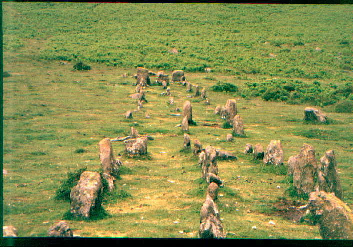
One of four triple rows on Dartmoor. Runs for 146m E (downhill) from a cairn. W half better preserved.

The Plague Market At Merrivale (Multiple Stone Rows / Avenue) — Links

A Dowser's Perspective


Photos and plans

The Plague Market At Merrivale (Multiple Stone Rows / Avenue) — Images

<b>The Plague Market At Merrivale</b>Posted by greywether<b>The Plague Market At Merrivale</b>Posted by greywether

Merrivale Stone Circle — Images

<b>Merrivale Stone Circle</b>Posted by greywether<b>Merrivale Stone Circle</b>Posted by greywether

Hart Tor (Stone Row / Alignment) — Images

<b>Hart Tor</b>Posted by greywether

Hurston Ridge (Stone Row / Alignment) — Links

A Dowser's Perspective


More photos and plans

Hurston Ridge (Stone Row / Alignment) — Images

<b>Hurston Ridge</b>Posted by greywether<b>Hurston Ridge</b>Posted by greywether

Sharpitor (Multiple Stone Rows / Avenue) — Images

<b>Sharpitor</b>Posted by greywether

Sharpitor (Multiple Stone Rows / Avenue) — Fieldnotes

Re pure joy's choice of name, it corresponds with that used by Burl so can be confirmed.

There are actually three rows here. The NW one is described below and is the best preserved. Double row running for 112m NE from cairn and ending in terminal stone.

N of the tor at SX561709 is a ruined double stone row running W from a cairn and visible for about 27m.

To the W, on the other side of the road at SX559707, is a single stone row running SW from a cairn for 132m ending in a terminal stone.

Hart Tor (Stone Row / Alignment) — Fieldnotes

To avoid crossing the River Meavy, park at Devil's Bridge on the B3212 and walk south along the east bank.

Two stone rows, one double (N) and one single (S). Both run roughly E/W from cairns at their E ends.

The N row runs for some 125m but is damaged in places by a ditch and a leat. An 1859 account says that it ended in a pillar 7.7m high which had fallen at that time. It is no longer there but would have been the largest on the moor. A low circle of stones surrounds the cairn.

The S row runs for 60m and is also damaged by a ditch. Its cairn is also surrounded by a circle of stones.

Hurston Ridge (Stone Row / Alignment) — Fieldnotes

Park on the B3212 near Warren House Inn and follow the footpath N.

Double stone row with 49 well preserved paired stones running northish from a cairn for about 140m and terminating in a blocking stone.

Soussons Common Cairn Circle — Miscellaneous

In a 1903 excavation of the cist, two large coils of human hair were found - apparently connected with contemporary withchcraft practices and not the original burial.

Yellowmead Multiple Stone Circle — Images

<b>Yellowmead Multiple Stone Circle</b>Posted by greywether

Yellowmead Multiple Stone Circle — Miscellaneous

The circles were reconstructed from the fallen stones in 1921 - apparently faithfully to their original positions.

There is another fourfold circle at Shovel Down.

Trowlesworthy Stone Row West (Stone Row / Alignment) — Images

<b>Trowlesworthy Stone Row West</b>Posted by greywether
Previous 50 | Showing 1851-1900 of 2,244 posts. Most recent first | Next 50
"Progress was all right. Only it went on too long."
James Thurber

My TMA Content: