
panorama view over the common from ‘Barrow 2’ towards the Great Pond – looking at ‘Barrow 3 + 4‘
Image credit: jonnee_l@soundnet associates ltd 2007
panorama view over the common from ‘Barrow 2’ towards the Great Pond – looking at ‘Barrow 3 + 4‘

‘Barrow 1’ – wow! although trampled and plundered this must be the prettiest covered Bronze Age burial mound in the whole of SE england?!
Following up on slumpystones interesting discovery I had to see this site for myself.
I’d like to think if this pile of stones had any significance it would have been fenced off (without the iron railings! ;0) ) and lovingly had the upkeep of English Heritage!
But --- on first appearance this does seem to be a curiously dumped pile of sarsen stones, which are great to see considering most others from this area have long been broken up and all we can enjoy in Kent are the great significant remnants at Kits Coty and of course Coldrum. It’s just the way they have been dumped; thought I’d add some pictures for people to get a better view!
At least four of the stones (including the ‘shaped’ triangular ones) are buried very deeply, all the rest are of various different shapes and cuts have character, the two at the back are absolutely huge; the main triangular stone with the hotly disputed cup and ring marks looks to me like a lot of glacial weathering, but I am way far from being an expert;
Even more curious is that there are further stones located a short distance nearby deep in the undergrowth – a single smoothed buried ‘post’ stone approx 15ft further NE from the collection, and two stones (again one very deeply buried) 30ft SE easily seen from the beaten path.


180 degree view from the outer earthworks on Mount Caburn

View of Mount Caburn from Ranscombe Camp

Panorama view approaching Mount Caburn... with Windover Hill and Firle Beacon to the left of picture – Mount Caburn enclosure – and Ranscombe Camp to the right.

sheep nibbling away around the barrow located nearest to Mount Caburn: grid ref TQ445092. Firle Beacon and Windover Hill in the distance!

Tumulus at grid ref TQ577009 on the South Downs Way, south east from Bourne Hill

Tumulus at grid ref TQ579020, Cold Crouch, south east from Coombe Hill (seen on the left)

The disc barrow by the Coombe Hill Neolithic enclosure looking south east

View from the middle of the enclosure, looking east to the east bowl barrow, the disc barrow on the centre right. The enclosure and banks are hard to portray via photo, but this gives an idea of the surrounding countryside.

panorama view of the bowl barrow to the east of the Coombe Hill Neolithic enclosure

Coombe Hill (or The Combe) certainly warrants a visit if you are in the South East Of England. I found it best to approach walking from the village of Jevington and following the South Downs Way, and if armed with an OS map (recommended!) you will notice there are plenty of other barrows marked on the way.
The top of the Hill has spectacular views and the three barrows are indeed impressive and extremely well looked after, so much so that the disc barrow is easy to define. If you walk south east then south from the enclosure you can be treated to further barrows, that are less impressive but worth a visit. I got to the large one at the top of Bourne Hill (TQ577009) before heading back to Jevington after an exhilarating and breathtaking walk on a fab summers’ day in the East Sussex countryside.

Ranscombe Camp, as seen down from Mount Caburn, September 2006


Parish council sign at the edge of Hilly Fields. Up from The Hare and Hounds pub and public footpath. Top pub! Well worth dropping in for a snifter or two after a hard days Modern Anitquarian wandering (and hopefully NO digging!)

View of barrow(s) from NW edge of Hilly Field
Godstone Village in Surrey provides a central hub to explore various interesting sites ranging from the Mesolithic, Bronze and Iron Ages.
This is great to find just outside of the M25 and a short trip away from London!
Recent Mesolithic finds are found at North Park Farm
Near to the village are the remains of some Bronze Age tumuli and are well worth checking out. North of the village green – take the public footpath by the Hare And Hounds pub and after 100 yards or so enter the field marked as Hilly Fields which is marked as owned by English Heritage, and follow the path(s) to the north where there is an obvious incline containing supposedly two Bronze Age barrows. There are no signs but a deliberate path has been cut and takes you up and onto a clearly defined mound – where the centre appears slightly hollow (no doubt from historical digging).
I struggled to pinpoint the location of the second barrow due to the summer plant growth (yay! thistles too!) but presumed it was directly south on the rise below the main barrow. The field undulates before you with many possibilities that this could have been a cemetery, but is rudely cut off to the north by a fence and the boundary to a private reservoir.
To the south east of the village and the Parish church at Leigh Place there is evidence of an Iron Age fort and a spring called Diana… link here
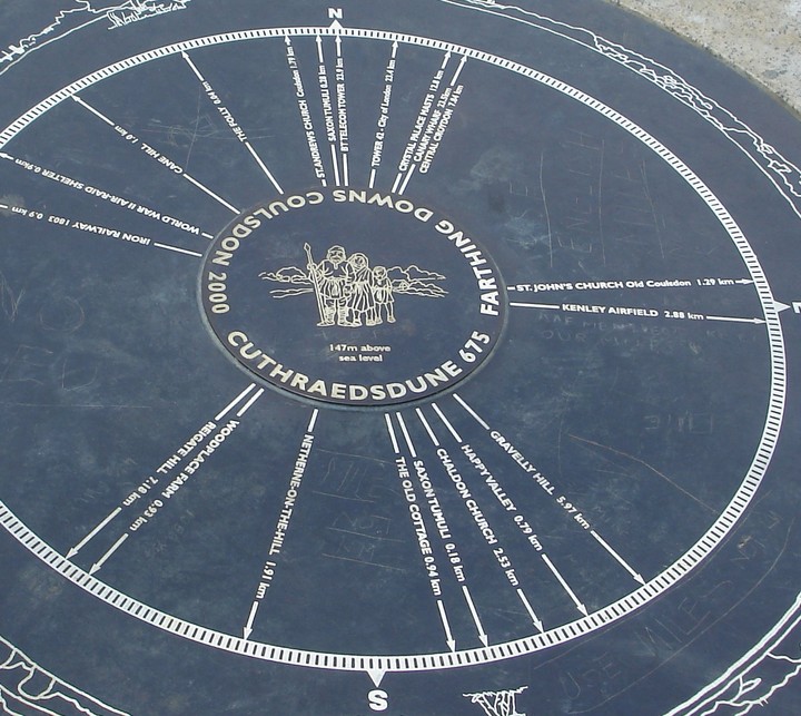
detail of the Cairn giving directions to the tumili and surroundings... with cartoon depiction of some er,
previous inhabitants of the area times gone bye?!...

The centre of Farthing Downs, looking south with more tumili and Iron Age earhworks ahead... and the Millenium Cairn which has good pointers to the nearby features on the landscape...

The main predominant mound of the cemetary, on the horizon (centre right) in the cluster of Saxon tumili – before reaching the Folly and Cairn – heading south...

Chalk and flint lanscape of Farthing Downs – difficult to capture, but depicted are the remains of some of the Saxon cemetary mounds...
A real treasure to discover in South London, and close to Croydon!
Stone / Iron Age, Roman and Saxon history in abundance – all located on common open grassland on a ridge leading into the North Downs and ancient woodlands and pastures, that commands great views stretching as far as to The City and Docklands around the surrounding urban and rural landscape.
Visible today are low banks indicating ancient trackways and Iron Age fields, and the excavated remains of several 6th or 7th century Saxon burial mounds, of which at least seven are clearly defined on the Downs’ landscape.

View from The Ring with barrow (seen in the middle) and cross ditch (below the horizon)

Large stone built into the wall at Sloe Lane

Three small stones south of Alfriston Church
The pretty village of Alfriston has so much to intrigue, considering it’s location with Firle Beacon to the west and Wilmington to the east. Going by the extensive write up here I tried to track down some of the stones mentioned. Go the church and note the mound it is built on. Three small stones (that could have been imported from Brighton) are located south on the green under a clump of trees, then take it from there. At the north of the village head west down North Street which leads to a (very steep!) path up the South Downs where some barrows and Long Burgh are located.
Oh, there are four pubs too!

View of possible barrow at OS ref: TQ236504, looking west. It is very difficult to gain any perspective amongst the trees and woods, but well worth wandering around and guessing!
This site is easily found and well worth checking out, for all those close to South London and have a car, to find the best examples of possible Bronze Age barrows as close to London as you may find (the next being possibly Croham Hurst in South Croydon).
Take the A25 route from Reigate to Dorking and less than 1km from the town centre you will easily see a turn off into the Heath down Flanchford Road – you can park in a dedicated car park a few hundred yards down. Cross the road and heading NE, you are on the heathland and upon the first of the tumuli that are marked on the nearby council information board – though it is very difficult to discern from the rest of the increasingly undulating landscape that unfolds the further you walk on…
Carry on up the main path and into the trees and take your guess and use your instincts as to where exactly the other tumuli might be – despite the claim to there being seven barrows here! There are two more pronounced barrow like formations as indicated on the notice board and OS maps at TQ236504 (picture to follow) and TQ237505, approx. 30 ft in diameter, with no discernable alignment, and a possible 2 or more north of these a little off the beaten path and very close to the edge of the A25/Buckland Road.
It is an attractive area to walk around despite the close proximity of yet another damn golf course! (re: Addington and Gally Hills closer to Croydon) but you can freely navigate this area! – and do take time to venture south west towards and up around the windmill/chapel for a perspective on the landscape, with rewarding views all around, especially the Downs to the north!


Happpened upon Morden Park as a detour from wandering along the River Wandle nearby… Despite the iffy history (Roman; built upon previous older pre-historic remains and burial ground?) it is a clearly contrived mound built for some special purpose that makes you wonder.
Sadly littered and graffitied, with the mentioned information sign at the top of the mound removed, probably vandalised; (and yes – if you can deal with the muddy trek!) – despite that it is a wee oasis of calm in London, and commands quite a dominant position in the landscape with views all around, especially more spectacular at this time of year looking at the Winter sun setting through the trees…

The Countless Stones – September 2004
