
panorama view over the common from ‘Barrow 2’ towards the Great Pond – looking at ‘Barrow 3 + 4‘
Image credit: jonnee_l@soundnet associates ltd 2007
panorama view over the common from ‘Barrow 2’ towards the Great Pond – looking at ‘Barrow 3 + 4‘

‘Barrow 1’ – wow! although trampled and plundered this must be the prettiest covered Bronze Age burial mound in the whole of SE england?!


180 degree view from the outer earthworks on Mount Caburn

View of Mount Caburn from Ranscombe Camp

Panorama view approaching Mount Caburn... with Windover Hill and Firle Beacon to the left of picture – Mount Caburn enclosure – and Ranscombe Camp to the right.

sheep nibbling away around the barrow located nearest to Mount Caburn: grid ref TQ445092. Firle Beacon and Windover Hill in the distance!

Tumulus at grid ref TQ577009 on the South Downs Way, south east from Bourne Hill

Tumulus at grid ref TQ579020, Cold Crouch, south east from Coombe Hill (seen on the left)

The disc barrow by the Coombe Hill Neolithic enclosure looking south east

View from the middle of the enclosure, looking east to the east bowl barrow, the disc barrow on the centre right. The enclosure and banks are hard to portray via photo, but this gives an idea of the surrounding countryside.

panorama view of the bowl barrow to the east of the Coombe Hill Neolithic enclosure


Ranscombe Camp, as seen down from Mount Caburn, September 2006


Parish council sign at the edge of Hilly Fields. Up from The Hare and Hounds pub and public footpath. Top pub! Well worth dropping in for a snifter or two after a hard days Modern Anitquarian wandering (and hopefully NO digging!)

View of barrow(s) from NW edge of Hilly Field
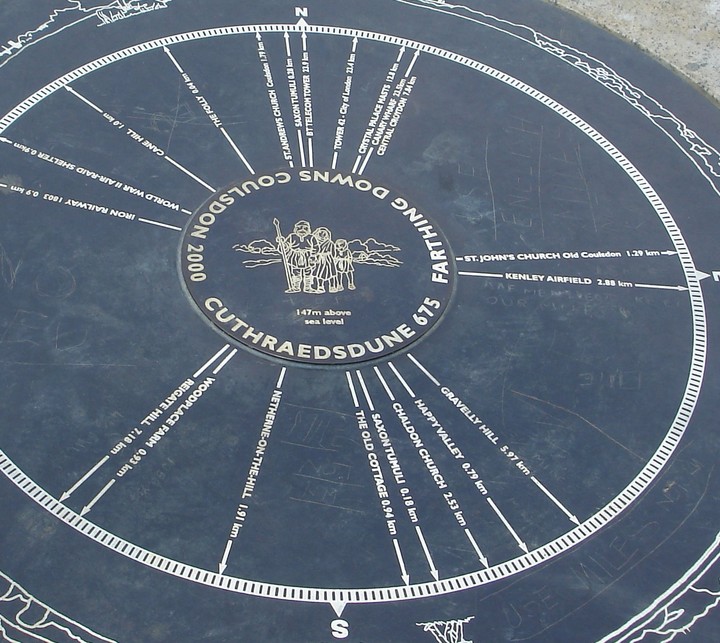
detail of the Cairn giving directions to the tumili and surroundings... with cartoon depiction of some er,
previous inhabitants of the area times gone bye?!...

The centre of Farthing Downs, looking south with more tumili and Iron Age earhworks ahead... and the Millenium Cairn which has good pointers to the nearby features on the landscape...

The main predominant mound of the cemetary, on the horizon (centre right) in the cluster of Saxon tumili – before reaching the Folly and Cairn – heading south...

Chalk and flint lanscape of Farthing Downs – difficult to capture, but depicted are the remains of some of the Saxon cemetary mounds...

View from The Ring with barrow (seen in the middle) and cross ditch (below the horizon)

Large stone built into the wall at Sloe Lane

Three small stones south of Alfriston Church

View of possible barrow at OS ref: TQ236504, looking west. It is very difficult to gain any perspective amongst the trees and woods, but well worth wandering around and guessing!


The Countless Stones – September 2004
