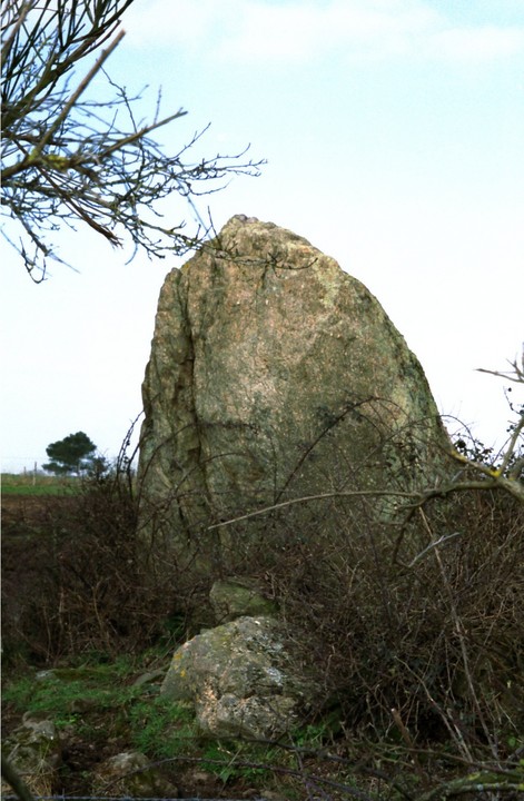
The Modern Antiquarian
Log in
|
Register
Home
Latest Posts
Forums
Maps
Help
Browse Sites
News
Blog
Contributors
The Books
Select
-
Belgium
Denmark
Eire
France
Germany
Greece
Italy
The Netherlands
Norway
Portugal
Republic of Malta
Spain
Sweden
Switzerland
United Kingdom
Loire-Atlantique (44)
Menhir de Mégerie
Standing Stone / Menhir
Menhir de Mégerie (Standing Stone / Menhir) on The Modern Antiquarian, the UK & Ireland's most popular megalithic community website. 1 image, 1 fieldnote, plus information on many more ancient sites nearby and across the UK & Ireland.
Image © Mark Williamson
Latitude:
47° 14' 57.55" N
Longitude:
2° 4' 50.86" W
Added by
Spaceship mark
Images (1)
Fieldnotes (1)
0 discussions
Start a topic
Show |
Hide
Web searches for Menhir de Mégerie
Flickr
Google
Google Images
Bing
Stone Pages
Wikipedia
Show map
(inline Google Map)
- Sites within 20 km -
-
Menhir des Cassis (0.48km WSW) (2 posts)
Menhir de Pierre Bonde (1.63km NE) (2 posts)
Menhirs des Pierres Blanches (2.26km N) (3 posts)
Dolmen de la Briordais (4.64km WSW) (2 posts)
Menhir de Plessis-Gamat (5.55km W) (2 posts)
Dolmen des Rossignols (6.77km WSW) (4 posts)
Menhir du Menhir (7.21km SW) (2 posts)
Menhir du Boivre (7.56km SW) (3 posts)
Tumulus Des Mousseaux (15.08km S) (5 posts)
Tumulus de Dissignac (15.19km W) (5 posts)
Joselière Dolmen (16.33km SSE) (2 posts)
- Add -
-
Add news
Add an image
Add fieldnotes
Add folklore
Add miscellaneous
Add a link
-
Add a site
Add an alternative name/spelling
Images
(click to view fullsize)
Add an image
Fieldnotes
Add fieldnotes
Another chunky menhir guarded by, not just a fence, but cows too! Could be on a mound or it could just be the pricklys that the cows don't want to eat. NEXT!
Comments (0)
|
Add a comment
|
Permalink
Posted by
Spaceship mark
6th November 2007ce