The Modern Antiquarian
Log in
|
Register
Home
Latest Posts
Forums
Maps
Help
Browse Sites
News
Blog
Contributors
The Books
Select
-
Belgium
Denmark
Eire
France
Germany
Greece
Italy
The Netherlands
Norway
Portugal
Republic of Malta
Spain
Sweden
Switzerland
United Kingdom
County Carlow
Brandon Hill
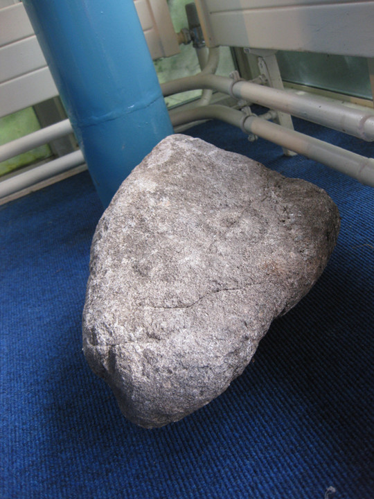
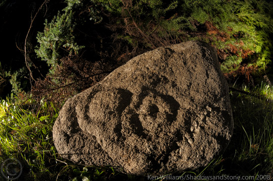
Cup and Ring Marks / Rock Art
Brandon Hill (Cup and Ring Marks / Rock Art) on The Modern Antiquarian, the UK & Ireland's most popular megalithic community website. 2 images, plus information on many more ancient sites nearby and across the UK & Ireland.
Image © Ken Williams/ShadowsandStone.com 2008
Nearest Town:
Graiguenananagh (0km E)
OS Ref (IE):
S707437 /
Sheet: 68
Latitude:
52° 32' 24.56" N
Longitude:
6° 57' 28.27" W
Added by
CianMcLiam
Images (2)
0 discussions
Start a topic
Show |
Hide
Web searches for Brandon Hill
Flickr
Google
Google Images
The Megalithic Portal
Bing
Stone Pages
Wikipedia
Show map
(inline Google Map)
- Sites within 20 km -
-
Carriglead (2.5km E) (0 posts)
Brandon Hill (3.57km SSW) (0 posts)
Newtown (4.18km ENE) (2 posts)
Ullard (4.9km NNE) (5 posts)
St Mullin's Well (5.88km SE) (2 posts)
Ballinvarry Irish (5.89km SSE) (1 post)
Tinncarrig (6.06km ENE) (5 posts)
Dranagh (now in St. Mullins) (6.12km SE) (6 posts)
Gowlin (6.69km E) (0 posts)
Dranagh Standing Stone 2 (6.93km ESE) (4 posts)
Cullaun (7.03km S) (0 posts)
Dranagh (7.04km ESE) (2 posts)
Kyle (7.5km NE) (0 posts)
Dranagh (7.9km ESE) (2 posts)
Dranagh Cairn(s) (8.16km ESE) (2 posts)
Aghnaglear (8.72km E) (3 posts)
Kilmissan (8.74km ENE) (0 posts)
Rathgeran Hill (9.05km ENE) (8 posts)
Kilmissan (9.05km ENE) (0 posts)
Rathgeran (9.14km ENE) (7 posts)
Ballyellin and Tomdarragh (9.15km NNW) (3 posts)
Knockmore (9.16km NE) (2 posts)
Rathgeran Upper (9.25km ENE) (3 posts)
Ballinasilloge (9.38km NNE) (11 posts)
Spahill (9.58km NE) (2 posts)
Curraun (9.74km ESE) (2 posts)
Tomdarrach (9.9km NNW) (2 posts)
Rathgeran (10.07km ENE) (4 posts)
Kilgraney (11.49km NNW) (11 posts)
Killoughternane (11.9km NE) (0 posts)
Killoughternane/Knockscur (11.9km NE) (4 posts)
Knockscur (11.93km NE) (0 posts)
Ballinkillin (12.56km N) (3 posts)
Ballinkillin (12.58km N) (0 posts)
Knockroe (12.61km ENE) (6 posts)
Crannagh (12.74km NE) (0 posts)
Knockroe (12.97km ENE) (9 posts)
Crannagh (13.19km ENE) (3 posts)
Kilcruit (13.28km N) (2 posts)
Slievebawn (14.83km NE) (5 posts)
Mount Leinster (14.9km NE) (5 posts)
The Nine Stones (15.44km NE) (4 posts)
Fenniscourt (15.65km NNW) (7 posts)
Commons or Newtown (15.88km SE) (4 posts)
Irishtown (15.92km SSE) (3 posts)
Lacken (15.98km SE) (0 posts)
Glencloghlea (16.08km S) (6 posts)
Ballylowra (16.28km WSW) (4 posts)
Coolasnaghta (16.66km NE) (2 posts)
Toberbride (17.02km NNE) (0 posts)
Shanbogh (17.18km S) (1 post)
Freestone Hill (17.22km WNW) (3 posts)
Freestone Hill (17.22km WNW) (3 posts)
Ryleen (17.73km SE) (0 posts)
Robinstown Great (17.8km ESE) (11 posts)
Clarabricken (18.34km WNW) (0 posts)
Curraghacruit (18.63km N) (0 posts)
Smithstown (18.84km SSW) (1 post)
The Three Friars (19.02km SW) (3 posts)
Dunleckny (19.11km N) (1 post)
Rossard (19.75km ENE) (0 posts)
- Add -
-
Add news
Add an image
Add fieldnotes
Add folklore
Add miscellaneous
Add a link
-
Add a site
Add a nearby facility
Add an alternative name/spelling
Images
(click to view fullsize)
Add an image