The Modern Antiquarian
Log in
|
Register
Home
Latest Posts
Forums
Maps
Help
Browse Sites
News
Blog
Contributors
The Books
Select
-
Belgium
Denmark
Eire
France
Germany
Greece
Italy
The Netherlands
Norway
Portugal
Republic of Malta
Spain
Sweden
Switzerland
United Kingdom
County Carlow
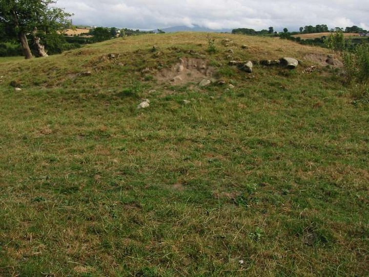
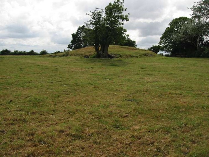
Kilcruit
Cairn(s)
Kilcruit (Cairn(s)) on The Modern Antiquarian, the UK & Ireland's most popular megalithic community website. 2 images, plus information on many more ancient sites nearby and across the UK & Ireland.
Image © ryaner
Nearest Town:
Goresbridge (4km SSW)
OS Ref (IE):
S709570 /
Sheet: 68
Latitude:
52° 39' 34.7" N
Longitude:
6° 57' 7.41" W
Added by
FourWinds
Images (2)
0 discussions
Start a topic
Show |
Hide
Web searches for Kilcruit
Flickr
Google
Google Images
The Megalithic Portal
Bing
Stone Pages
Wikipedia
Show map
(inline Google Map)
- Sites within 20 km -
-
Ballinkillin (1.61km E) (0 posts)
Kilgraney (1.93km SSW) (11 posts)
Ballinkillin (2.1km E) (3 posts)
Fenniscourt (2.85km WNW) (7 posts)
Tomdarrach (3.49km S) (2 posts)
Ballyellin and Tomdarragh (4.39km SSW) (3 posts)
Curraghacruit (5.43km N) (0 posts)
Dunleckny (5.88km N) (1 post)
Ballinasilloge (5.91km ESE) (11 posts)
Toberbride (6.06km ENE) (0 posts)
Spahill (6.99km ESE) (2 posts)
Killoughternane (7.45km E) (0 posts)
Killoughternane/Knockscur (7.45km E) (4 posts)
Kildreenagh 2 (7.5km NE) (2 posts)
Kildreenagh (7.61km NE) (5 posts)
Knockscur (7.67km E) (0 posts)
Rathwade (7.99km N) (0 posts)
Leighlinbridge (8.6km NNW) (5 posts)
Ullard (8.82km SSE) (5 posts)
Slievebawn (9.91km E) (5 posts)
Mount Leinster (10.01km E) (5 posts)
Coolasnaghta (10.37km E) (2 posts)
Kyle (10.66km ESE) (0 posts)
Knockmore (10.8km ESE) (2 posts)
Crannagh (10.83km E) (0 posts)
The Nine Stones (11.02km E) (4 posts)
Rathoman (11.04km NNW) (0 posts)
Tinncarrig (11.12km SE) (5 posts)
Kilmissan (11.88km ESE) (0 posts)
Myshall (11.94km ENE) (3 posts)
Rathgeran (11.95km ESE) (7 posts)
Freestone Hill (11.97km WSW) (3 posts)
Freestone Hill (11.97km WSW) (3 posts)
Rathgeran Hill (12.1km ESE) (8 posts)
Crannagh (12.13km E) (3 posts)
Kilmissan (12.42km ESE) (0 posts)
Clarabricken (12.85km W) (0 posts)
Rathgeran Upper (12.88km ESE) (3 posts)
Newtown (12.98km SE) (2 posts)
Huntsman's Cross Road (13.03km NE) (0 posts)
Rathgeran (13.26km ESE) (4 posts)
Brandon Hill (13.28km S) (2 posts)
Knockbower (13.33km NNE) (0 posts)
Knockroe (13.55km E) (9 posts)
Knockbrack Cairns (13.83km ENE) (0 posts)
Knockbrack (14.12km ENE) (2 posts)
Carriglead (14.62km SSE) (0 posts)
Knockroe (14.67km ESE) (6 posts)
Knockbarragh (14.87km ENE) (0 posts)
Gowlin (15.14km SE) (0 posts)
Sragh (15.74km ENE) (0 posts)
Kilmurray (15.96km ENE) (0 posts)
Brandon Hill (16.73km S) (0 posts)
Aghade (18.25km NE) (4 posts)
Aghnaglear (18.35km SE) (3 posts)
Rossard (18.42km E) (0 posts)
Cloch An Phoill (Aghade) (18.49km NE) (9 posts)
St Mullin's Well (18.87km SSE) (2 posts)
Glenoge (18.9km NNE) (2 posts)
Dranagh (18.96km SSE) (2 posts)
Ballynoe (18.97km NE) (1 post)
Dranagh Standing Stone 2 (18.99km SSE) (4 posts)
Killenora (19.01km NNE) (0 posts)
Dranagh (now in St. Mullins) (19.1km SSE) (6 posts)
Ballinvarry Irish (19.17km S) (1 post)
Dranagh Cairn(s) (19.38km SE) (2 posts)
Ardristan (19.48km NE) (11 posts)
Ardristan 2 (19.48km NE) (0 posts)
Dranagh (19.49km SE) (2 posts)
Ardattin (19.66km ENE) (3 posts)
Busherstown (19.71km NNE) (0 posts)
- Add -
-
Add news
Add an image
Add fieldnotes
Add folklore
Add miscellaneous
Add a link
-
Add a site
Add a nearby facility
Add an alternative name/spelling
Images
(click to view fullsize)
Add an image
 Image © ryaner