These notes date from the cold 'Spring' of last year. Again, should've put them on at the time....
A 'higher than expected' cloudbase looms above the eastern-most ridge of The Black Mountains, the more-or-less uniform, clean-cut lines of these snow-clad uplands (defining, with uncharacteristic finality, the England/Wales border) simultaneously mirroring and opposing the darkly menacing sky today. Perhaps the somewhat malignant vibe I sense this morning is influenced by the knowledge that today is April 1st.... April Fool's Day. Yeah, this traveller's summary rejection of the sundry self-serving tenets of organised religion notwithstanding, it is clearly not so easy to banish all superstition with Mr Spock logic when venturing forth in the great outdoors. One can feel so very small and insignificant.... so vulnerable. And rightly so. Guess the best I can offer by way of explanation is the feeble acknowledgement of entering an environment beyond normal everyday perception, a recognition of willingly subjecting the self to stimuli likely to result in sensory overload, to a greater or lesser degree. Perhaps a parallel can be drawn with the shamans of old, such a mental state enabling the individual to access primeval neural circuits long since filed away in the deepest recesses of the human genome, thought processes selected for animal survival, not logical deliberation. But enough cod-psychology... despite the passing of a sudden, freezing shower, I decide to head for the hills. Yeah, in the words of Andy Partridge... 'I've got 1,2,3,4,5; Senses working overtime'.
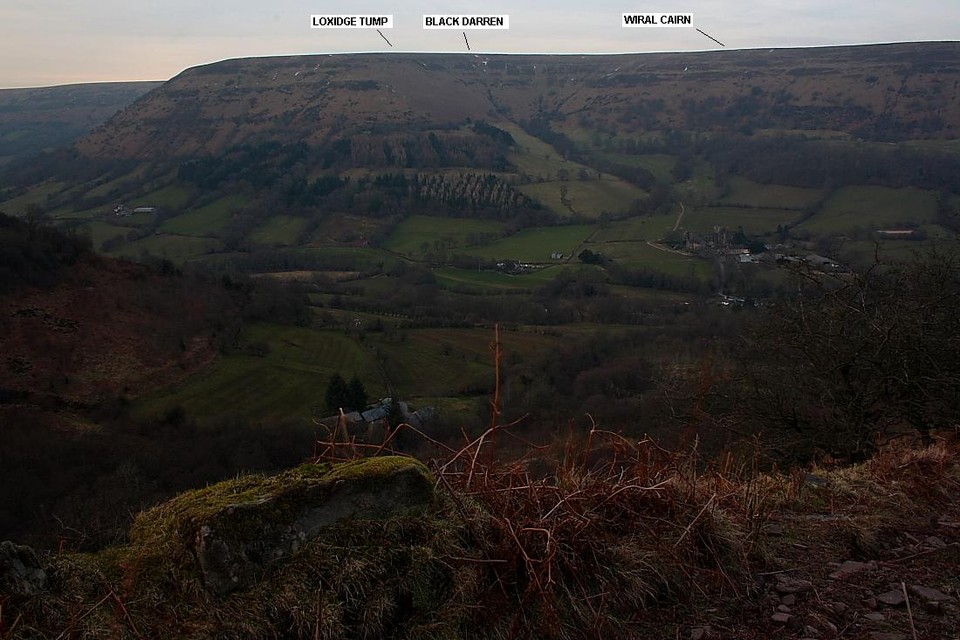
Walking back down the road from the (not surprisingly) almost empty car park adjacent to the gaunt ruins of Llanthony Priory a gate allows access to pasture land upon the gently rising southern slopes of Cwm Siarpal. I head for the foot of Loxidge Tump forming the left hand (western) flank of the cwm. From here a steep climb, with some fine retrospective views across the Vale of Ewyas to Cwm Bwchel etc, sees me eventually emerge upon bare, open hillside, the landscape now in the unrelenting, icy grasp of winter raiment above the snow line..... despite it ostensibly being Spring! Continuing approx north along the rim of the cwm the view south(ish) toward the great promontory fort of Hatterrall Hill is truly one to behold, sufficient reward for the inclement conditions underfoot. Not to mention the biting wind, the actions of which ensure 'I 'aint seen nothing yet' by having applied a progressively more potent 'freezing crust' to the snow mantle as I gain height. Hence what is - assuming my previous visit with the Mam C back in 2008 is any yardstick - a reasonably straightforward walk is transformed today into a full-on struggle for every step.
Consequently the appearance of the Bronze Age cairn is most welcome... in more ways than one. It is not a commanding monument, at least not in its surviving form, and appears even less so when almost subsumed within the snow! Nevertheless I'm determined not to repeat the error of yore and actually manage to remember to look at the map - for once - the cairn located a little west of the cwm headwall, to the left of the path.... assuming the path isn't obscured by snow, that is. Plonking myself on top it is immediately clear what a superb location this is, the sweeping view across Cwm Siarpal to the wondrous Vale of Ewyas (in my opinion) matching the aesthetic appeal of some of the area's top vistas. Hey, well worth the effort of a fine approach. Needless to say it's bloody freezing but, fortified by an inner glow like some post-Cold War 'Ready Brek kid', I discover that there is an excellent vibe to be enjoyed here upon this frozen far-from-waste-land.
After hanging out for a while I slowly - very slowly, not by choice but out of necessity - head approx north-west in an ultimately unsuccessful attempt to locate an 'enclosure' marked upon the 1:25k map. Snow too deep, unfortunately. Indeed... half way to the summit of Red Daren, the OS trig point conspicuous upon the far horizon, it dawns on me that my progress is so slow that I must choose between reacquainting myself with it .... or finally getting 'round to checking out Black Darren's cairn. Not enough time to do both justice. Suffice to say I choose the latter.
Another of a series of Bronze Age funerary cairns which surmount the most easterly ridge of The Black Mountains, this also doubling as the England/Wales border.
The Loxidge Tump cairn, well sited overlooking Cwm Siarpal and the beautiful Vale of Ewyas, is most directly reached via a popular path ascending from Llanthony Priory to the Offa's Dyke Long Distance route, the latter following the aforementioned ridge. As such, the Mam C and I have walked right by the monument without realising what is was. Doh!
According to Coflein it is 'A cairn, 6.5m in diameter and 0.7m high. (source Os495card; SO22NE8) J.Wiles 03.09.02'.


 Posted by GLADMAN