The Modern Antiquarian
Log in
|
Register
Home
Latest Posts
Forums
Maps
Help
Browse Sites
News
Blog
Contributors
The Books
Select
-
Belgium
Denmark
Eire
France
Germany
Greece
Italy
The Netherlands
Norway
Portugal
Republic of Malta
Spain
Sweden
Switzerland
United Kingdom
County Louth
Ballinloughan
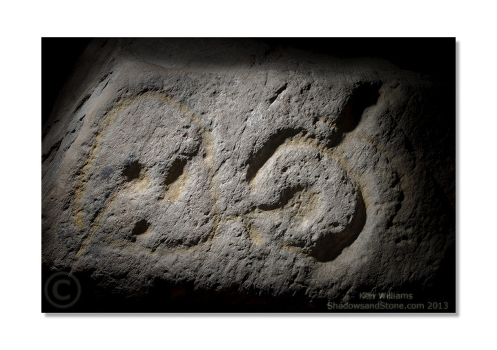
Cup and Ring Marks / Rock Art
Ballinloughan (Cup and Ring Marks / Rock Art) on The Modern Antiquarian, the UK & Ireland's most popular megalithic community website. 1 image, plus information on many more ancient sites nearby and across the UK & Ireland.
Image © Ken Williams/ShadowsandStone.com 2013
OS Ref (IE):
Latitude:
54° 0' 16.8" N
Longitude:
6° 23' 46.43" W
Added by
CianMcLiam
Images (1)
0 discussions
Start a topic
Show |
Hide
Web searches for Ballinloughan
Flickr
Google
Google Images
Bing
Stone Pages
Wikipedia
Show map
(inline Google Map)
- Sites within 20 km -
-
Castletown - Standing Stone (2.37km W) (4 posts)
Castletown (2.42km W) (0 posts)
Castletown - Souterrain (2.42km W) (0 posts)
Carn Beg (2.84km NW) (5 posts)
Balriggan (4.31km NW) (1 post)
Proleek (4.81km NE) (12 posts)
Proleek (4.81km NE) (31 posts)
Killin (5.01km WNW) (0 posts)
Lurgankeel (5.04km WNW) (0 posts)
Lurgankeel (5.23km WNW) (4 posts)
Faughart (5.34km NNW) (6 posts)
Cortial (5.54km WSW) (5 posts)
Cuchulains Stone (Rathiddy) (5.61km SW) (8 posts)
Ballymakellet (6.16km NE) (3 posts)
Ballymakellet Standing Stone (6.22km NE) (1 post)
Drumnasillagh (6.45km NNE) (7 posts)
Aghnaskeagh Chambered Cairn (6.75km NNE) (3 posts)
Aghnaskeagh (6.85km NNE) (2 posts)
Rockmarshall (7.36km ENE) (7 posts)
Kilnasaggart (7.61km N) (0 posts)
Carnawaddy (8.89km NE) (5 posts)
The Meadow (8.96km NE) (0 posts)
Drumsinnot (9.12km W) (8 posts)
Standing Stone (9.21km S) (0 posts)
Crannog (9.27km S) (0 posts)
Clermont Cairn (9.53km NE) (0 posts)
Drumgonnelly (9.62km WSW) (3 posts)
Ravensdale Park (9.67km NE) (10 posts)
Tullagee (9.98km WSW) (1 post)
Drumcah (10.54km WSW) (3 posts)
Corrakit (11.07km NE) (0 posts)
Riverstown (11.46km E) (0 posts)
Drumirril (11.6km WSW) (6 posts)
Clontygora - Court Tomb (12.83km NNE) (38 posts)
Callaigh Berra's Lough (12.96km NNW) (6 posts)
Grange Irish (Court Tomb) (13.16km ENE) (0 posts)
Callaigh Berra's House (13.19km NNW) (39 posts)
Commons (13.21km ENE) (4 posts)
Clonlum South (13.23km NNW) (9 posts)
Grange Irish (Ruined Tomb) (13.28km ENE) (0 posts)
Souterrain (13.52km ENE) (0 posts)
Miskish More (13.91km W) (1 post)
Clonlum (14.04km NNW) (3 posts)
Slieve Gullion - North Cairn (14.15km NNW) (10 posts)
Grange Irish cairn (14.16km ENE) (3 posts)
Carranmore (14.16km ENE) (0 posts)
Grange Irish bullaun (14.35km ENE) (4 posts)
Grange (14.44km ENE) (0 posts)
Warrenpoint Standing Stone (15.24km NE) (4 posts)
Latbirget (15.38km NW) (5 posts)
Ballykeel (15.48km NW) (24 posts)
Mucklagh (16km ENE) (0 posts)
Tullynavall (16.04km WNW) (4 posts)
The Ballard Longstone (16.4km NNW) (7 posts)
Ballymacdermot (16.57km N) (27 posts)
Burren (17.26km NNE) (6 posts)
The Well of The White Cow (17.36km SW) (3 posts)
Ballyedmond Cairn (17.4km ENE) (0 posts)
The Dorsey Entrenchment (17.76km NW) (7 posts)
Cross (17.93km N) (8 posts)
Annaghmare (17.93km WNW) (27 posts)
Rostrevor Standing Stone (18.03km NE) (6 posts)
Aghmakane (18.18km NNW) (6 posts)
Slieveemartin Cairn (18.21km ENE) (0 posts)
North Stone (18.49km SSW) (0 posts)
Barnaveddoge Mound (18.68km SSW) (0 posts)
South Stone (18.76km SSW) (2 posts)
Ballintur (18.94km ENE) (0 posts)
Dunany Point (19.13km ESE) (1 post)
Knockshee (19.19km ENE) (3 posts)
Knockdinnin (19.19km S) (0 posts)
Monalty Lough (19.21km WSW) (0 posts)
Skeaghmore (19.36km SSE) (0 posts)
Kilfeaghan (19.7km ENE) (13 posts)
Tamnaharry (19.84km NE) (0 posts)
Roestown (19.92km SSW) (0 posts)
- Add -
-
Add news
Add an image
Add fieldnotes
Add folklore
Add miscellaneous
Add a link
-
Add a site
Add a nearby facility
Add an alternative name/spelling
Images
(click to view fullsize)
Add an image