Log in
|
Register
Home
Latest Posts
Forums
Maps
Help
Browse Sites
News
Blog
Contributors
The Books
Select
-
Belgium
Denmark
Eire
France
Greece
Italy
The Netherlands
Norway
Portugal
Republic of Malta
Spain
Sweden
Switzerland
United Kingdom
England
Southern England
Wiltshire
Casterley Camp
Hillfort
Casterley Camp (Hillfort) on The Modern Antiquarian, the UK & Ireland's most popular megalithic community website. 2 images, 1 piece of folklore, plus information on many more ancient sites nearby and across the UK & Ireland.
Image © Sir Richard Colt Hoare Cir.1810
Nearest Town:
Devizes (14km WNW)
OS Ref (GB):
SU115535 /
Sheet: 184
Latitude:
51° 16' 47.9" N
Longitude:
1° 50' 6.36" W
Added by
pure joy
Images (2)
Folklore (1)
Miscellaneous (1)
0 discussions
Start a topic
Show |
Hide
Web searches for Casterley Camp
Flash Earth
Flickr
Google
Google Images
MAGIC
The Megalithic Portal
Bing
Stone Pages
Streetmap.co.uk
Wikipedia
Show map
(inline Google Map)
- Sites within 20 km -
-
Enford (2.34km ESE) (5 posts)
Broadbury Banks (3.02km WNW) (2 posts)
Slay Barrow (3.6km SW) (1 post)
Chisenbury Camp (3.7km ENE) (1 post)
Ell Barrow (4.7km WSW) (1 post)
Lidbury Camp (5.13km E) (1 post)
Marden Henge (and Hatfield Barrow) (5.32km NW) (31 posts)
Net Down (5.41km SSW) (1 post)
Grant's Firs Group (6.26km ENE) (1 post)
Woodborough Holed Stone (6.33km NNW) (6 posts)
Swanborough Tump (6.66km N) (9 posts)
East Down Long Barrow (6.85km SW) (2 posts)
Gallows Barrow (6.85km ESE) (6 posts)
The Hanging Stone (7.17km NNW) (6 posts)
Everleigh Barrows (7.27km ENE) (13 posts)
Sheer Barrow (7.51km ESE) (1 post)
Robin Hood's Ball (7.59km S) (5 posts)
Picked Hill (7.66km N) (13 posts)
Down Farm Group (7.85km ENE) (5 posts)
Knighton Longbarrow (8.3km SSE) (11 posts)
Ridgeway (Southernmost Remains) (8.32km NNW) (9 posts)
Pewsey (8.39km NE) (12 posts)
Pewsey Church (8.45km NE) (10 posts)
Weather Hill Long Barrow (8.46km E) (1 post)
Comesdeane Well Long Barrow (8.55km E) (5 posts)
Alton Priors (8.62km NNW) (21 posts)
Giant's Grave (Milton Hill) (8.73km ENE) (17 posts)
Brade Wyll (8.76km NNW) (1 post)
Weather Hill (9.11km E) (8 posts)
Larkhill Camp Long barrow (9.14km SSE) (3 posts)
Fargo Compound Group (9.25km S) (1 post)
Silver Barrow (9.34km SW) (10 posts)
Oldhat Barrow (9.36km ENE) (13 posts)
Durrington Down Group (9.4km SSE) (1 post)
Adam's Grave Fallen Stone (9.41km NNW) (5 posts)
Hot Cross Bun (9.43km E) (4 posts)
MOD Durrington (9.57km SE) (10 posts)
Old Coach Road Barrows (9.71km E) (3 posts)
Adam's Grave (9.89km NNW) (61 posts)
Knap Hill Pass (9.95km N) (1 post)
Strangeways Group (10.03km SSE) (1 post)
Lesser Cursus (10.04km S) (0 posts)
Barrows south-west of Knap Cottage (10.09km N) (1 post)
Knap Hill (10.11km N) (37 posts)
Summer Down (10.13km ENE) (16 posts)
Walker's Hill Barrows (10.24km NNW) (1 post)
Knap Hill car park Barrows (10.26km N) (3 posts)
Dunch Hill Barrow (10.33km E) (9 posts)
Silk Hill (10.33km ESE) (1 post)
Snail Down (10.35km E) (5 posts)
White Horse Barrow (10.39km NNW) (1 post)
Durrington Walls (10.49km SE) (34 posts)
Sidbury Hill (10.5km E) (5 posts)
Knap Cottage Barrows (10.52km N) (2 posts)
White Barrow (10.56km SW) (9 posts)
Milston Down Firs (10.57km ESE) (5 posts)
Knap Cottage Enclosures (10.57km N) (2 posts)
Golden Ball Hill (10.58km N) (7 posts)
Knap Cottage Stone (10.59km N) (1 post)
The Stonehenge Cursus (10.61km S) (52 posts)
Cursus Longbarrow (10.62km SSE) (10 posts)
Cuckoo Stone (10.65km SE) (20 posts)
Draycott Hill (10.66km N) (19 posts)
Fargo Plantation Henge (10.7km S) (3 posts)
Stonehenge Cursus Group (10.7km SSE) (36 posts)
Woodhenge (10.71km SE) (46 posts)
Monarch of the Plain (10.75km S) (7 posts)
New Henge (To be named) (10.79km S) (0 posts)
Rybury (10.87km NW) (22 posts)
Old King Barrows (10.88km SSE) (14 posts)
Giant's Grave (Martinsell) (10.94km NNE) (7 posts)
Winterbourne Stoke Down Long Barrow (10.96km S) (3 posts)
Gate Ditch (10.96km SSE) (4 posts)
Godsbury (11.06km ENE) (5 posts)
Stonehenge Car Park Post Holes (11.1km SSE) (11 posts)
Tilshead Lodge Longbarrow (11.12km WSW) (9 posts)
Easton Clump (11.15km ENE) (3 posts)
The Avenue (11.17km SSE) (18 posts)
Altar Stone (11.25km SSE) (5 posts)
Stonehenge (11.25km SSE) (422 posts)
Tan Hill (11.28km NW) (12 posts)
Stonehenge Palisade (11.29km SSE) (12 posts)
Station Stones (11.3km SSE) (3 posts)
Droveway Long Barrow (11.33km SSE) (1 post)
Seven Barrows (Tidworth Camp) (11.34km E) (5 posts)
Old Ditch Longbarrow (11.35km SW) (22 posts)
Amesbury 11 Bell Barrow (11.36km SSE) (7 posts)
Bulford Longbarrow (11.41km SE) (18 posts)
New King Barrows (11.45km SSE) (18 posts)
Oval Twin Disc Barrow (11.52km SSE) (1 post)
Stonehenge Down (11.52km SSE) (2 posts)
Cow Down (11.54km E) (2 posts)
Milston Down Barrow Group (11.58km ESE) (1 post)
Amesbury Bowl Barrow (11.6km SSE) (6 posts)
Winterbourne Stoke East Group (11.62km SSW) (1 post)
Countess Farm (11.66km SE) (1 post)
Stonehenge Urn (A303) Barrow Group (11.67km SSE) (2 posts)
Normanton Gorse Long Barrow (11.74km SSE) (1 post)
Bulford Camp Barrows (11.8km ESE) (1 post)
King Barrow (Winterbourne Stoke) (11.87km S) (1 post)
Winterbourne Stoke Group (11.89km S) (26 posts)
Bulford (11.99km SE) (2 posts)
Tan Hill (west) (12.01km NW) (11 posts)
Coneybury Henge (site) (12.04km SSE) (3 posts)
Martinsell (12.09km NNE) (12 posts)
Winterbourne Stoke West Group (12.1km SSW) (1 post)
Vespasian's Camp (12.16km SSE) (25 posts)
Bush Barrow (12.19km SSE) (26 posts)
Normanton Down (12.19km SSE) (20 posts)
Little Avebury (12.19km N) (9 posts)
Kitchen Barrow (12.21km NW) (10 posts)
Bluestonehenge (12.29km SSE) (7 posts)
King Barrow (Coneybury Hill) (12.29km SSE) (3 posts)
Ratfyn Barrow (12.33km SE) (5 posts)
Normanton Down Long Barrow (12.42km S) (1 post)
Milston Down Long Barrows (12.43km ESE) (21 posts)
Allington Down (12.48km NNW) (8 posts)
Normanton Down Neolithic Mortuary Enclosure (12.49km S) (1 post)
Southly Bridge Barrows (12.51km E) (5 posts)
Barrow Copse (12.73km NNE) (21 posts)
Kill Barrow (12.74km WSW) (1 post)
Harestone Down Stone Circle (12.89km NNW) (17 posts)
Lake Group Earthwork (13km S) (5 posts)
King Ina Earthworks (Eastern section) (13.22km E) (3 posts)
Prophet Barrow (13.23km S) (2 posts)
Ratfyn Barrow Group (13.29km SE) (1 post)
East Kennett Longbarrow (13.29km N) (41 posts)
Lake Group (13.3km S) (14 posts)
Ludgershall 1 (13.32km E) (7 posts)
Lake Group Long Barrow (13.32km S) (1 post)
Windmill Hill (Ludgershall) (13.34km E) (3 posts)
Ludgershall 2 (13.34km E) (7 posts)
Boscombe Bowmen (13.35km SE) (4 posts)
Horton Down (13.38km NW) (2 posts)
Pickpit Hill Barrow (13.51km E) (2 posts)
Easton Down (13.62km NW) (12 posts)
Roughridge Hill (13.62km NW) (6 posts)
Amesbury Area Burials (13.64km SE) (1 post)
Devil's Ditch (13.64km ESE) (7 posts)
Wilsford Group (13.69km SSE) (0 posts)
Beckhampton Plantation Stone Circle (13.75km NNW) (3 posts)
Beckhampton Penning Barrow Cemetery (13.83km NNW) (1 post)
Amesbury Archer (13.94km SE) (4 posts)
Lockeridge Dene (14.07km N) (18 posts)
Newton Barrow Group (14.19km SE) (1 post)
Lake Down Group (14.19km SSE) (0 posts)
White Barrow (Lockeridge) (14.22km N) (1 post)
West Kennett Round Barrow Pair (14.23km NNW) (1 post)
West Kennett (14.33km NNW) (195 posts)
West Kennett Five Barrows (14.34km NNW) (1 post)
Overton Hill (14.39km N) (45 posts)
Fairmile Down (14.41km ENE) (21 posts)
Amesbury Down (14.44km SSE) (1 post)
Beckhampton Penning Enclosure (14.46km NNW) (1 post)
The Sanctuary (14.49km N) (64 posts)
Swallowhead Springs (14.56km NNW) (34 posts)
West Kennett Palisaded Enclosures (14.6km NNW) (5 posts)
Silbaby (14.82km NNW) (26 posts)
Baltic Farm (14.83km NW) (1 post)
Berwick St James (14.85km SSW) (8 posts)
Stukeley's Disc Barrow (14.89km NNW) (1 post)
Lake House (14.92km SSE) (7 posts)
North Down (15.01km NW) (12 posts)
Silbury Hill (15.17km NNW) (210 posts)
Piggle Dene (15.3km N) (14 posts)
Yarnbury Castle (15.33km SSW) (29 posts)
Ogbury Camp (15.43km SSE) (2 posts)
West Kennet Hollow Way (15.45km NNW) (1 post)
Wilbury House (15.49km ESE) (1 post)
West Down Long Barrow (15.51km NW) (1 post)
West Down Roman Road Barrows (15.52km NW) (1 post)
Waden Hill (15.52km NNW) (4 posts)
Furze Knoll (15.65km WNW) (1 post)
West Kennett Avenue Barrow (15.7km NNW) (1 post)
Wagon and Horses Barrow Cemetery (15.73km NNW) (1 post)
West Kennet Avenue Settlement Site (15.76km NNW) (1 post)
Grafton Disc Barrows (15.78km ENE) (7 posts)
Falkners Circle Mounds (15.8km NNW) (1 post)
Falkner's Circle (15.8km NNW) (28 posts)
Falkners Circle Barrow (15.81km NNW) (1 post)
Long Stones (15.82km NNW) (15 posts)
Granham Hill (15.83km NNE) (2 posts)
Beckhampton Road Enclosures (15.85km NNW) (2 posts)
Mother Anthony's Well (15.86km WNW) (7 posts)
Oliver's Castle (15.88km WNW) (21 posts)
South Street (15.88km NNW) (11 posts)
West Down (15.92km NW) (0 posts)
Beckhampton Avenue (15.97km NNW) (13 posts)
Penning Barn (15.98km NNW) (3 posts)
Clatford Barrows (15.98km N) (1 post)
The Longstone Cove (16km NNW) (53 posts)
Falkners Circle Long Barrow (16.01km NNW) (1 post)
West Kennett Avenue (16.03km NNW) (114 posts)
Morgan's Hill (16.07km WNW) (16 posts)
Longstones Neolithic Enclosure (16.08km NNW) (1 post)
Avenue stone with axe grinding marks (16.09km NNW) (7 posts)
Broad Stones (Clatford) (16.21km NNE) (2 posts)
Little Down (Great Durnford) (16.21km SSE) (1 post)
King's Play Hill (16.22km WNW) (14 posts)
Knoll Down Barrows (16.27km NW) (1 post)
West Down Gallops Barrows (16.29km NW) (1 post)
Manton Round Barrow (16.37km NNE) (10 posts)
Tow Barrow (16.42km ENE) (18 posts)
Ring-stone or Handfasting stone (16.43km NNW) (6 posts)
Pickledean Cairn (16.49km N) (2 posts)
Pickledean Stone Circle (16.5km N) (4 posts)
Avebury Henge Enclosure (16.53km NNW) (1 post)
Avebury (16.57km NNW) (455 posts)
Devil's Den (16.59km N) (101 posts)
The Cove (16.62km NNW) (48 posts)
Marlborough Mound (16.63km NNE) (27 posts)
Laundry Bungalows (16.69km ESE) (1 post)
Yatesbury Field Cursus Group (16.93km NW) (1 post)
Barton Copse Barrows (17km NNE) (1 post)
Cherhill Down and Oldbury (17.01km NW) (46 posts)
Barrow Field Clumps (17.05km ESE) (4 posts)
Yatesbury Field Cursus (17.07km NW) (1 post)
Experimental Earthwork (17.14km N) (7 posts)
The Mother's Jam (17.19km N) (14 posts)
Oldbury Long Barrow (17.19km NW) (7 posts)
Horslip (17.23km NNW) (6 posts)
Overton Down (south) (17.25km N) (2 posts)
Knoll Down Earthwork (17.29km NW) (1 post)
Crofton (17.33km ENE) (2 posts)
Fyfield 1 and 2 barrows (17.35km N) (3 posts)
Monster Stone (17.38km N) (6 posts)
Avebury Down (17.39km NNW) (16 posts)
Fyfield Down (17.5km N) (8 posts)
Castle Barrow (17.64km WSW) (1 post)
Tinhead Hill (17.68km WSW) (1 post)
Penning (17.69km NNW) (10 posts)
Forest Hill Farm (17.8km NNE) (5 posts)
Yatesbury (17.95km NW) (0 posts)
Newton Barrow (17.96km S) (1 post)
Marlborough Common Golf Course Barrows (17.97km NNE) (2 posts)
Yatesbury Field Barrow (18.02km NW) (1 post)
Long Tom (18.02km N) (12 posts)
Little London Pair (18.05km NNW) (8 posts)
Manton Down (18.07km N) (16 posts)
Picket Barrow (18.08km NNW) (7 posts)
Tidcombe Long Barrow (18.09km ENE) (17 posts)
Windmill Hill (18.1km NNW) (70 posts)
Knook Castle (18.13km WSW) (1 post)
Knook Barrows (18.15km WSW) (2 posts)
Little London Barrow (18.44km NW) (1 post)
Winterbourne Monkton (Churchyard) (18.46km NNW) (8 posts)
Quarley Hill (18.52km ESE) (5 posts)
Codford Circle (18.56km SW) (2 posts)
Boles Barrow (18.63km WSW) (3 posts)
Kenward Stone (18.81km ENE) (13 posts)
Yatesbury Village Barrow (18.81km NW) (1 post)
Ebsbury Hill (18.87km SSW) (1 post)
Grovely Castle (18.9km SSW) (3 posts)
The Bloodstone (18.91km WSW) (3 posts)
Botley Copse (18.95km ENE) (1 post)
Merewether's No 29 (19.04km N) (1 post)
Temple Bottom (19.29km N) (4 posts)
East Castle (19.3km SSW) (4 posts)
Noland's Farm Barrow (19.35km NW) (1 post)
Mount Wood (19.36km NW) (10 posts)
Winterbourne Gunner Group (19.4km SE) (1 post)
Old Chapel (19.44km N) (2 posts)
Upton Great Barrow (19.48km SW) (3 posts)
Rough Hill Barrows (19.5km N) (1 post)
Rough Hill Row (19.58km N) (1 post)
- Facilities within 20 km -
-
The Millstream (Pub: 5.3 km NW)
The Barge Inn (Pub: 8.2 km NNW)
Travelodge Amesbury St... (Motor Lodge: 12 km SSE)
Amesbury Friar Tuck Cafe (Cafe: 12.7 km SSE)
Devizes Museum (Museum: 13.3 km WNW)
The Wiltshire Heritage... (Museum: 13.3 km WNW)
The Crown Inn (Pub: 13.3 km NW)
The Old Forge (Bed & Breakfast: 13.9 km N)
Avebury Tourist Inform... (Tourist Information: 16.5 km NNW)
The Red Lion Inn (Pub: 16.7 km NNW)
Alexander Keiller Museum (Museum: 16.7 km NNW)
Manor Farm (Bed & Breakfast: 16.7 km NNW)
The Lodge Avebury (Bed & Breakfast: 16.7 km NNW)
Teachers Cottage (Holiday Cottage: 16.7 km NNW)
Marlborough Tourist In... (Tourist Information: 17 km NNE)
Raj Indian Restaurant (Restaurant: 17.4 km NNE)
Cafe in a bus (Cafe: 17.6 km S)
Avenue Farm (Camping Site: 18.6 km NNW)
The New Inn (Bed & Breakfast: 18.6 km NNW)
- Add -
-
Add news
Add an image
Add fieldnotes
Add folklore
Add miscellaneous
Add a link
-
Add a site
Add a nearby facility
Add an alternative name/spelling
Images
(click to view fullsize)
Add an image
Photographs:
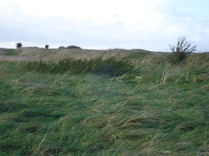
Maps / Plans / Diagrams:
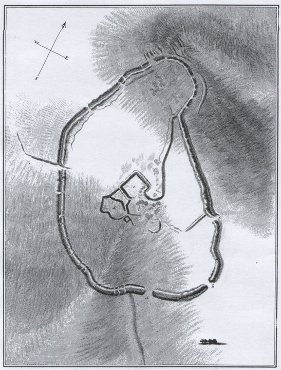
Folklore
Add folklore
There was a belief that a gold chair was buried in the ramparts. Another old story says that Upavon village was originally sited at Casterley Camp.
Comments (0)
|
Add a comment
|
Permalink
Posted by
pure joy
26th March 2003ce
Miscellaneous
Add miscellaneous
When this Iron Age hillfort was excavated four human burials and 14 red deer antlers were apparently found, which seems slightly unusual.
Comments (0)
|
Add a comment
|
Permalink
Posted by
pure joy
26th March 2003ce