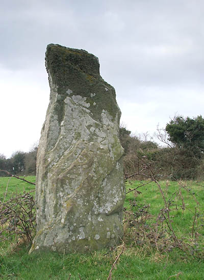
The Modern Antiquarian
Log in
|
Register
Home
Latest Posts
Forums
Maps
Help
Browse Sites
News
Blog
Contributors
The Books
Select
-
Belgium
Denmark
Eire
France
Germany
Greece
Italy
The Netherlands
Norway
Portugal
Republic of Malta
Spain
Sweden
Switzerland
United Kingdom
County Louth
Baltray
Standing Stones
Baltray (Standing Stones) on The Modern Antiquarian, the UK & Ireland's most popular megalithic community website. 11 images, 1 weblink, plus information on many more ancient sites nearby and across the UK & Ireland.
Image © Anthony Murphy, www.mythicalireland.com
Nearest Town:
Drogheda (7km WSW)
OS Ref (IE):
O154762 /
Sheet: 43
Latitude:
53° 43' 21.59" N
Longitude:
6° 15' 5.58" W
Added by
FourWinds
Images (11)
Links (1)
1 discussion topic
Start a topic
Show |
Hide
Web searches for Baltray
Flickr
Google
Google Images
The Megalithic Portal
Bing
Stone Pages
Wikipedia
Show map
(inline Google Map)
- Sites within 20 km -
-
Termonfeckin (4.64km NW) (0 posts)
Laytown (An Inse) (4.89km S) (6 posts)
Dardisrath (5.42km NNW) (0 posts)
Drogheda (5.97km WSW) (0 posts)
Bey More (6.43km WSW) (0 posts)
Milltown (6.68km WNW) (0 posts)
Clogher Head (8.21km NNE) (1 post)
Fieldstown (9.62km W) (7 posts)
Piperstown (9.81km WNW) (1 post)
Gormanston (10km SSE) (6 posts)
Gormanston Beach (10.01km SE) (3 posts)
Oldbridge (10.08km WSW) (7 posts)
Walshestown (10.16km NW) (0 posts)
Drumshallon (10.3km WNW) (0 posts)
Mullahteelin (10.51km SSW) (0 posts)
Labanstown (10.73km NNW) (0 posts)
Bremore (11.01km SE) (36 posts)
Townley Hall Barrow (11.65km W) (0 posts)
Hilltown Little (11.75km SW) (0 posts)
Cloghalea (11.97km WSW) (6 posts)
Bellewstown (11.99km SW) (5 posts)
Dowth Henge (12.12km WSW) (10 posts)
Townley Hall Souterrain (12.35km W) (0 posts)
Paddock (12.44km W) (15 posts)
Dowth Mound I (12.54km WSW) (0 posts)
Dowth II (12.56km WSW) (1 post)
Greenanstown (12.59km SSW) (4 posts)
Littlegrange (13.06km WSW) (9 posts)
Herbertstown (13.16km SSW) (4 posts)
Dowth (13.24km WSW) (4 posts)
Dowth I (13.25km WSW) (68 posts)
Tullog (13.45km S) (0 posts)
Dowth Mound III (13.46km WSW) (0 posts)
Skeaghmore (13.53km NW) (0 posts)
Kilbride (Talbotstown Lower By.) (13.55km W) (6 posts)
Dowth Mound II (13.66km WSW) (0 posts)
Longford (13.72km WSW) (0 posts)
Hodgetown (13.9km S) (0 posts)
Heathtown Henge II (14.03km SSW) (5 posts)
Heathtown Mound (14.12km SSW) (4 posts)
Hedgerow Stone (14.23km WSW) (2 posts)
Mellifont (14.26km W) (0 posts)
Newgrange Tumulus B (14.31km WSW) (3 posts)
Micknanstown (14.49km SSW) (2 posts)
Monknewtown II (14.56km WSW) (3 posts)
Heathtown Henge I (14.61km SSW) (0 posts)
Newgrange Tumulus A (14.64km WSW) (3 posts)
Fourknocks (14.68km SSW) (5 posts)
Monknewtown (14.76km WSW) (2 posts)
Fourknocks (14.77km SSW) (35 posts)
Newgrange Cursus (14.86km WSW) (2 posts)
Monknewtown Pond (14.97km WSW) (4 posts)
Newgrange (15.05km WSW) (128 posts)
Newgrange Standing Stone C (15.15km WSW) (6 posts)
The Great Circle (15.15km WSW) (23 posts)
Dunany Point (15.17km N) (1 post)
Newgrange K & L (15.25km WSW) (10 posts)
Inch (15.51km SE) (0 posts)
Balrothery (15.66km SE) (7 posts)
Boolies Great (15.94km SW) (0 posts)
Knowth (15.94km WSW) (120 posts)
Westown North (16.29km S) (1 post)
Kichenstown (16.37km S) (0 posts)
Knockbrack (16.47km S) (0 posts)
Balgeeth (16.61km SW) (2 posts)
Barnageeragh (16.82km SE) (2 posts)
Knockbrack (16.87km S) (1 post)
Gaulstown (17.08km SW) (3 posts)
Knockdinnin (17.56km WNW) (0 posts)
Rossnaree (17.76km WSW) (3 posts)
Moorepark (17.79km SW) (0 posts)
Hollywood Great (18.27km S) (1 post)
Nags Head (18.27km S) (0 posts)
Grange (18.29km SE) (11 posts)
Mount Oriel (18.54km W) (3 posts)
Stanley Hill (18.61km WSW) (0 posts)
Gallows Hill (18.63km WSW) (0 posts)
Hill of Slane Souterrain (18.76km WSW) (0 posts)
Damastown (18.79km S) (3 posts)
Mallahow (18.91km S) (0 posts)
Balcunnin (19.09km SE) (3 posts)
Ho Stone, Balcunnin (19.1km SE) (2 posts)
Rathmaiden (19.25km W) (0 posts)
Hill of Slane Barrow (19.35km WSW) (1 post)
Roadmain (19.55km SW) (0 posts)
Piercetown (19.59km SW) (0 posts)
Johnstown (19.6km WSW) (0 posts)
Mullaghash (19.61km W) (2 posts)
Mullaghash (19.61km W) (3 posts)
Garristown (19.7km SSW) (0 posts)
North Stone (19.77km WNW) (0 posts)
South Stone (19.87km WNW) (2 posts)
Dunmore (19.88km W) (0 posts)
- Add -
-
Add news
Add an image
Add fieldnotes
Add folklore
Add miscellaneous
Add a link
-
Add a site
Add a nearby facility
Add an alternative name/spelling
Images
(click to view fullsize)
Add an image
Links
Add a link
Mythical Ireland - Winter Solstice discovery at Baltray
Local researchers have discovered the Baltray standing stones have a Winter Solstice alignment, confirmed in local mythology.
Comments (0)
|
Add a comment
|
Permalink
Posted by
mythicalireland
11th November 2002ce
Edited 29th September 2004ce