Medway & Bucks
It's been a few weeks since I've had a serious stone-chasing trip. This week was no exception.
However, our various travels did afford an opportunity to meet some old friends on Saturday in the form of the Medway sites.
We wandered across the Thames and into the navigational black hole that is South London. Somehow, some way, we emerged near Croydon unscathed by the journey and with our passporst intact. Being gluttons for punishment we headed back in toward Beckenham to feed Mikki's retail leanings. After this came a bit more wandering, trying to rely on my unerring navigational ability, whioch sadly found us near another of her preferred outlets in the lovely village of Shoreham.
But at least I knew where I was now. We headed off down the A20 and were soon passing the bulk of Oldbury Camp, towards Addington, with Coldrum off to our left.
My objective today, if I were to admit having one, was to finally see the Coffin Stone. I looped up through Aylesford then off toward Eccles before heading back across toward Kits Coty and the area known as Great Tottington.
Whilst in the area, I also visited the Countless Stones and Kit's Coty, just to say hello again.
About 25 yards south of the Countless Stones is a turn off. I precariously parked here and crossed the road to an entrance to a bridleway to see if I could see the Coffin Stone in it's field. Luckily, the crop had been harvested, and the stone(s) stood proud of the field, in full sight. I didn't approach the stones on this ocassion, being contented enough just to see them, and not wanting to encroach on what is obviously a cropping field. A couple of hundred yards further south is an entrance to Great Tottington Farm. I may ask here next time for permission to actually visit the stones.
There is also supposedly a circle, or ruined circle of stones (The Tottington Sarsens) at the head of the stream on the farm. It would be interesting to see if anything remains of this site/monument.
We then popped into Rochester to browse the bookshops there and have a bite to eat before heading home. Baggins books has a good selection of archaeological books, but they don't discount, even for bulk purchases, so I left empty handed.
On Sunday, we headed up toward Whipsnade and checked out the Tree Cathedral, which was very peaceful and had a wonderful atmosphere about it for a couple of pagans like us, even if it is laid out in the form of a mediaeval Christian Cathedral. The chancel would be ideal for our handfasting...
From there, we headed off (the Whipsnade Lion could do with a good scouring!) past the car park for Ivinghoe Beacon and made our way across country, roughly following parallel to the route of the Icknield Way to Aston Clinton.
From here, it was a short drive down country lanes to take a look at Cholesbury Camp, an interesting site, where one quarter of the fortifications have been taken away to build a small housing estate, and a church resides in the fort itself.
Finally, the call of food won us over and we headed for Berkhamstead for a meal before, once again, heading for home.
Only three weeks before we hit Cornwall again...
|
Pottering about for new sites
I've been particularly taken with the MAGIC web site (www.magic.gov.uk) just recently.
Whenever Mikki wants to go to a new shop now, Magic is my first port of call. Many of the Scheduled Monuments on there are out of our timeframe, but there are occassional goodies that pop up.
This weekend was a Glocs and Oxon weekend again, so I checked out the site as usual. I *think* I've seen most of the major Oxon sites now, though there is always new stuff to see.
I decided on three potentially easy sites, Lad Barrow, New Street Stone and the Burnt Hill Dolmen for this week's excursion. Fieldnotes for all three are included below.
So off to Glocs, and after some heavy retail therapy I checked the map. We were very close to Barrow Elm barrow, just outside of Hatherop, so I checked there first. Very little to see, and so damaged/unrecognisable that I didn't feel it was worth adding to TMA. So we made our way up to Lad Barrow.
Visited this at the weekend, but not much to see, to be honest.
Parked at the bottom of the hill, there's a parking area at the junction with the main road. Pleasant enough walk up the hill (the road is marked as no through route for motor vehicles) - very quiet, even the traffic noise was negligable, so very peaceful.
If you walk up the road and reach the pylons, you passed the barrow. It's in a field to the left - no obvious way in and it's in the middle of a cultivated field so I didn't trespass to get to it at all. All that can be seen is an uncultivated 'lump', although there are apparently a couple of possible entrance stones to be seen.
There are good views all around. 2-300 yards difference in the location and it would be a different story though.
After the brisk walk up the hill, lunchtime beckoned, so we worked our way up toward Stow and Chipping Norton. Burford and Stow were both officially FULL - nowhere to park at all in either town, so we continued up toward Chastleton to search (unsuccessfully) for the Burnt Hill Dolmen.
I failed to find this at the weekend.
The EH Monuments record describes the site thus:
"The site lies on a gentle south east facing slope at the north east corner of a small wood.
The portal dolmen has one large upright and one adjacent inclined stone, together with a number of smaller stones on the northern side of a roughly square depression which measures 3m across and 0.2m deep. The upright limestone block measures 1.54m long, 0.72m thick and stands 0.94m high above the present ground level. The inclined stone immediately to the east measures 1m long, c.1m wide and 0.5m thick. Surrounding the central depression is a circular bank of small stones which measures c.10m in overall diameter. The bank is 2m wide and stands 0.4m high to the south."
I could see two possible candidates for the 'small wood', but couldn't find a way through the hedge from the road (which is a bit of a racetrack!) I'll have to leave this for someone more local to investigate further.
There is also a possible Long Barrow in the same vicinity, which is close to Chastleton Barrow Fort and the Goose Stones, so lots of evidence for this being an important centre at one time.
Heading for Chipping and our usual ports of call there - the New Mill Cafe, and the Old Bookshop, we briefly paid our respects to the New Street Stone which was just around the corner, then had a wonderful lunch and bought several books.
Popped in here on Saturday to pay our respects. As Jane says, it's almost totally hidden and you wouldn't know it was there unless you were specifically looking for it.
"You didn't see me, right?"
To finish the day off, we headed for Jane's abode. A wonderful afternoon of stones chat ensued, with Jane, her partner and the additional bonus of Treaclechops(!) before finally heading off home.
|
Not much of a stones weekend, really...
On Saturday, we decided to drive up to Suffolk, to revisit the bookshop in Clare, that has a good range of old topology and archaeology books at excellent prices. The only site we bothered with en-route was the Sturmer Barrow. I did have details of some other possibles on the way, including a cursus at Harlow, but the time didn't feel right for investigating further.
Taken from the EH Scheduled Monument record:
A bowl barrow situated on a west facing slope overlooking the River Stour. The barrow is visible as an earthen mound which measures 48m in diameter and 2.5m high. Although no longer visible at ground level, a ditch, from which material was excavated during its construction, surrounds the mound. The ditch has become infilled but survives as a buried feature 2m wide.
This bowl barrow 500m north-west of Sturmer Hall is well preserved.
On Sunday, we fancied a stroll down to the New Forest, and rather than hunt down more barrows, I set myself the task of trying to find the South Baddesley Stone. I failed.
South Baddesley is a small place: a church, a school and a few cottages. We parked in the church car park, a couple of hundred yards North off the Lymington-East End road.
I walked back down the lane to the junction, but could see no sign of a sarsen, even though the GPS said I was on the spot. There's a small triangle of grass at a junction with a side lane, that would have been an ideal spot if the stone had been moved, but it was bare.
Sadly it looks as if this is no more (or is now recumbent in a ditch, covered by undergrowth)
We stopped off on the way home at Figsbury Ring - a weird place with a most amazing collection of butterflies.
I only spotted this on the way home as I took a wrong turning. Parking in a layby I looked across and thought "hello, what's that?". Checking the map, the opportunity was too good to miss, and we carefully made our way up the deeply rutted track to the even more deeply rutted car park.
As others have said, the 'fort' is impressive. I was totally unprepared for the inner ditch, and knew right away that this was special in some way. It's a bit too 'jagged' for a proper henge ditch, to my mind, and looks a bit rough and ready.
Great views though, and a large and varied butterfly population.
The only Stones connection for the weekend was the traffic for the concert at Twickenham on the way home... but I don't suppose that counts?
|
A Hertfordshire Henge?
Today's task, on the face of it, was impossible. Find a henge monument in Hertfordshire!
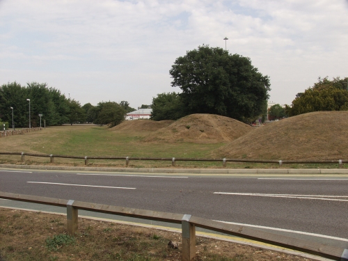
We started the day with a warm-up at Stevenage Six Hills, a series of Iron Age barrows.
I was quite surprised when I found out where these were. A few years ago, before my TMA interests, I’d attended a job interview in the modern office block that overlooks the mounds. I remember assuming at the time that they were just a modern landscaping feature…
Antiquarian descriptions state that the mounds were once all surrounded by ditches and outer banks, but these are no longer visible. What are visible today are the inevitable cycle tracks across the tops of the mounds, which are situated a short walk from the shopping centre. The mounds are fairly evenly spaced, on a N-S line. Only one is undisturbed, three having large depressions indicating where shafts have been sunk, and the two most southerly have been tunnelled from the sides.
All in all, a bit of an anachronism in the modern(!) town, but I’m glad they’ve managed to survive.
After a quick (2 hour!) visit to a craft fair for Mikki, we headed north toward Baldock, and Weston Hill Henge, which was easier to find than I'd expected although I needed the GPS to confirm the location, as there's not much to see at ground level.
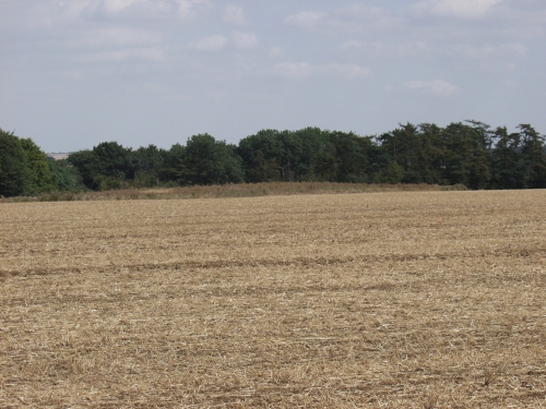
This is definitely one for the completists. The henge does not appear on the OS map, but is mentioned on the MAGIC web site as a scheduled monument. The henge is about 1m in height, and around 65m in diameter. There are apparently two opposing entrances, identified from crop marks, in the East and West. The Icknield Way passes by and is visible to the NE.
I approached on the path from the NW. The henge site can be seen across a field surrounded by barbed wire, showing signs warning of Rat Poison and other evils. Staying on the path (marked on the OS Map), and skirting around this field leads to the field with the henge in it. Luckily, the crop had recently been harvested and I crossed to the henge site itself, which was heavily overgrown with weeds. Sadly, there’s really not much to see here, unless you enjoy staring at an uncultivated patch of land surrounded by farmland. The site is associated with a local legendary giant called Jack O' Legs who was supposed to have lived in a cave nearby.
Various versions of the story exist. See http://www.mysteriousbritain.co.uk/england/hertfordshire/weston.html
http://www.ausbcomp.com/~frets/smwcmort.htm#LegendThe henge can faintly be seen, in the dark field, just south west of the trees.
On the way home, I decided to push my luck and seek out some barrows in Graffridge Wood, near Knebworth. The wood is wonderful, and teeming with life – game fowl abound, and the insect life is diverse and colourful. I managed to find the Roman barrow (TL 217209), but failed on the Bronze Age bowl and bell barrows (TL214208), mainly because the fern and bramble undergrowth was so dense. I had a nice walk in the woods though, which made up for the disappointment.
|
Essex Fringes
No real plan today, other than to head toward Southend and turn North up toward Suffolk and maybe take a look at Alphamstone before heading for home. We got as far as Raleigh (and the inevitable retail experience) before the traffic got 'difficult' on yet another 'hottest day of the year so far'.
Heading North we avoided the A12, which was also busy, and soon found ourselves at Halstead, northwards on the A131. A right turn signposted Pebmarsh put us on the road toward Alphamstone, and a friendly local pointed out that the church was around the next bend just as we thought we must have missed it.
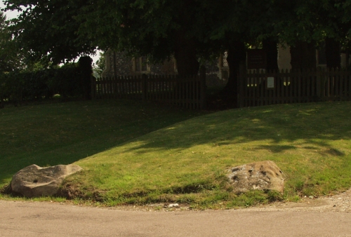
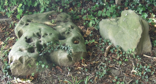
This is weird. A church, with a whole bunch of sarsens around it.
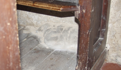
The two stones in front of the church are not in their original positions, according to a helpful local lady, who also pointed out the sarsen poking inside the SW wall of the church, under the rear pew. Reports of the number of stones varies. I thought I counted as many as 13 stones or remnants, but figures of 9,10 or 11 are more usually reported.
Was this originally a circle? It’s difficult to determine that from what I saw. Most of the stones are on the Southern edges of the churchyard rather than spread around. R*man fragments of a hypocaust were found in an adjoining field, and a kiln site lies nearby, so the area has been in use since the Iron Age, if not earlier.
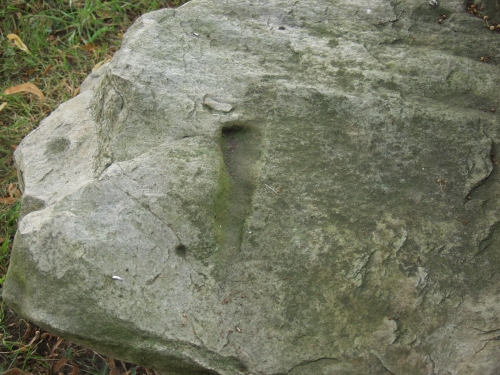
I'm no expert on cup marks, but several of the stones had round indentations in them. Could this be weathering? Another had a triangular 'groove' cut into it, which intrigued me - see photos for details of these.
We then headed across country through the Hedinghams, where we got lost and skirted through Sudbury. At Cavendish we stopped at the Sue Ryder Museum for a bite to eat in the cafeteria, which was nice. In the next village along, Clare, we spotted a bookshop and screeched to a halt. Good call, it was a goldmine and I picked up several archaeological themed books at knockdown prices (9 books for a tenner is a bargain in anyone's books). It proves it's always worth looking…
Slightly further along, we passed the site of a set of ring ditches at Chapel Farm (TL732434). I couldn't see any obvious evidence from the road, despite the crop having been harvested and the field recently ploughed, so we continued on.
At Saffron Walden, we passed close by the Maze, and were going to check out the hillfort at Ring Hill but decided against stopping as time was getting on.
The final stop of the day was reserved for Newport, just south of Saffron Walden.
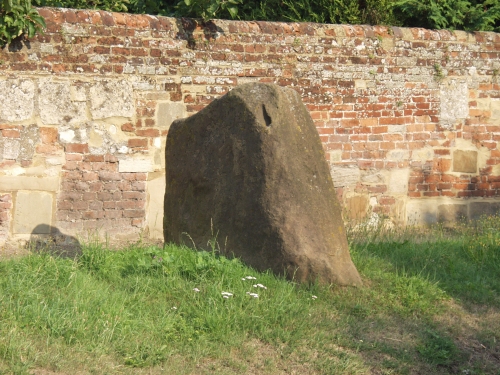
Just at the northern limit of the town, on the B1383, is the entrance to Shortgrove House. We parked here, and walked the 100 or so yards further south along the road to where the Leper Stone stands at the side of the road. This is a large stone, reportedly the largest in Essex.
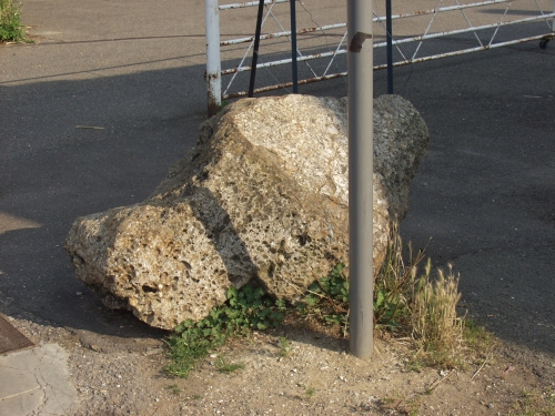
Slightly further south in the town, in Station Road lies a recumbent block of puddingstone outside the village hall.
|
|
An ex-Londoner based in West Cornwall, any sites on the wrong side of the Tamar are now effectively out of reach as time marches on for me.
I was usually accompanied on trips by my partner and soulmate Mikki, who is disabled and unable to walk far. I'm indebted to her for her patience and understanding.
Favourite place? Cornwall without a doubt. West Penwith in particular, Trencrom Hill as a prime example. The peninsular is so rich in sites and has an amazing atmosphere. Every trip there is like going home... Avebury currently comes a close second, but is starting to go the way of Stonehenge (see below) and Glastonbury for me - over-used and over-rated.
Most overrated? Stonehenge - I can't understand the excitement that this totally spoiled site induces in people. I first went there in the 1960's with school and have been back several times since. Each was an anti-climax.
|