|
|

|
|
FernworthyStone Circle
|
||||||||||||||||||||||||
|
|
|
Images (click to view fullsize) |
|
Photographs: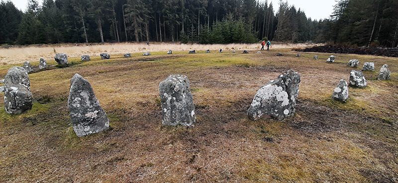


 Maps / Plans / Diagrams:
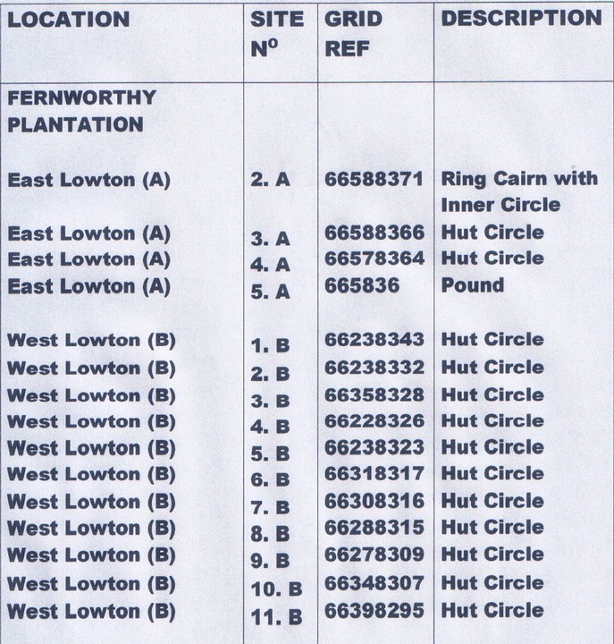
|
Fieldnotes |
|
|
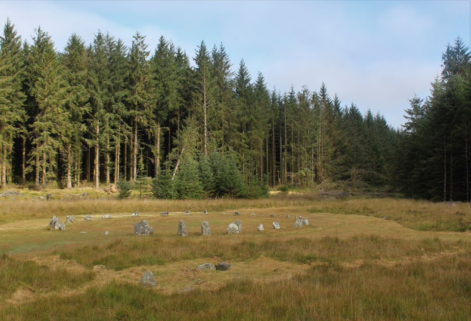
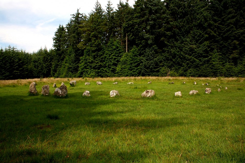
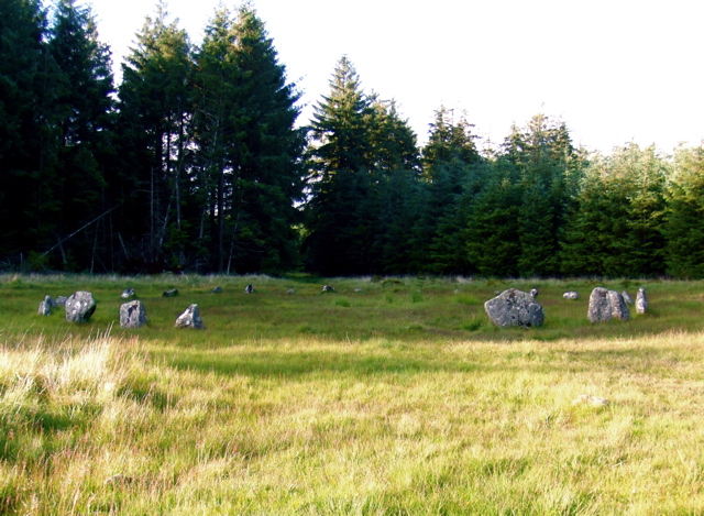
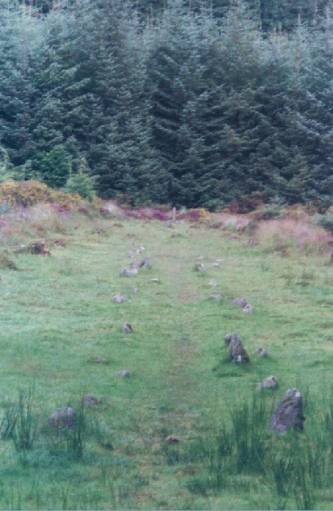
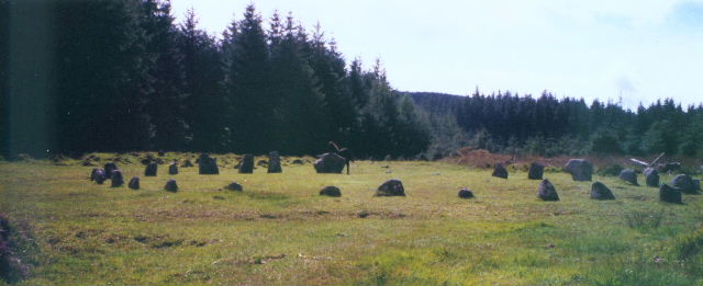
At last...in a landscape where any features of interest are hidden by dense forest and unfollowable tracks...a real stone circle! By the time I got to Fernworthy Circle I had given up on ever finding Assycombe...I navigate by reading the landscape and using an OS map...in forestry nothing ever corresponds with an OS map but I had decided that Assycombe required a climb...and under a baking sun and no wind the thought of climbing along paths that I had no way of telling if they were the right one or not did not entice me. So I had carried on to Fernworthy hoping that it would be easy to find...and it is. It sits inside a nice clearing which gave me the impression that this might have been how some of these circles were when they were erected all those years ago. (I know many will argue that this isn't so and that they would have been on top of hills so they could be seen..but) Part of me wanted to climb one of the trees on the edge of the clearing and look down onto the circle...but I feel my days of tree climbing are behind me...and looking at the spindly branches I decided to forgo this fancy. I had a quick look at the stone rows...mainly hidden by the midsummer grass..and then met up with another walker who offered to lead me through the maze of tracks to Grey Wethers.. |
3rd July 2010ce |
|
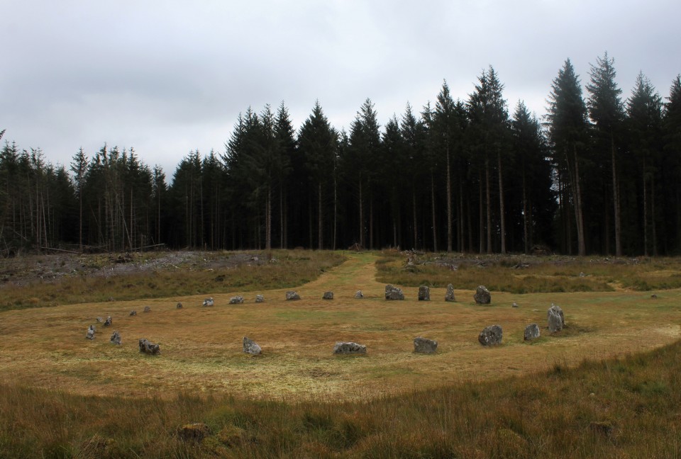
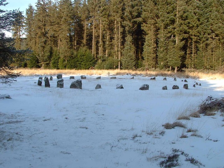
The short walk uphill on the forestry road from the car park by the reservoir took me 10 minutes (but then I don't walk fast uphill). The weather was still pretty nasty though the plantation gave us some protection. The circle and rows now lie in a clearing in the trees. This means there are no sight lines or views, but the circle captivated me, nevertheless. It is lovely here - the circle is small but not tiny and the stones are small, too, but in proportion to the diameter. They seemed to spin above the boggy ground and were watched by me and Moth and a battalion of purple foxgloves. Another 50 minutes walking would take us to the Greywethers, but given the climate today I had no intention of attempting it. It would have to wait. This post appears as part of the weblog entry The 'Must-Sees' we saw on Dartmoor
|
 Posted by Jane
10th July 2005ce Edited 10th July 2005ce |
|
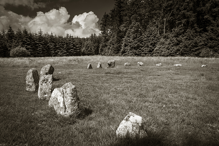
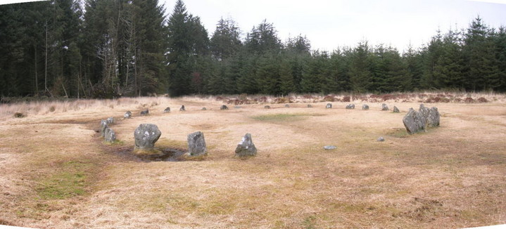
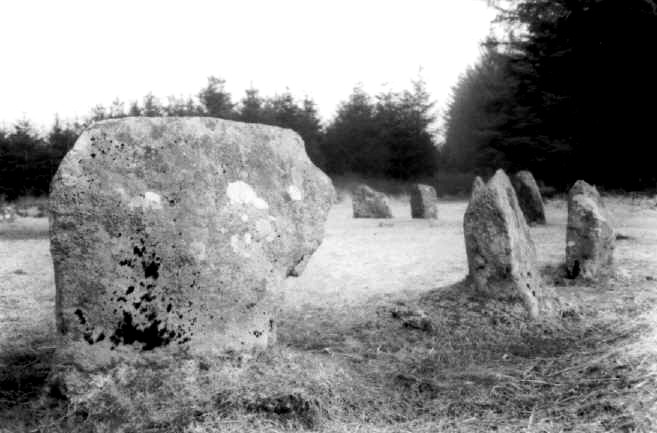
Visited 3rd October 2003 Like Martin, we drove as far as possible along the approach road, past the official car park. The forest track heads off to the left from this point (don't follow the footpath immediately ahead). The track rises steadily for a way (took me what felt like about 5-10 minutes, but with no watch it's hard to say). Suddenly the clearing appeared to the right. Two large stones proclaimed the entrance, but I think they're there to stop possible vehicles (which obviously use the track) from progressing further. The site opened up from this point on, everything being nicely laid out before me. There was no fire damage evident within the circle, although there was a fire pit just outside of it. What was obvious to me, was the slant of the circle, with taller stones on the south progressing down to smaller ones on the northern side. I'd seen this effect before, during our trip to Ireland earlier this year. I don't recall seeing this in other circles in this country, but then I don't remember what I had for breakfast this morning! Later: I saw this Frith photo which shows the site in 1907 - quite a difference! Access: A fair uphill trek to get to the area of the sites. I wouldn't want to push a wheelchair up here - it's quite a bumpy path. This post appears as part of the weblog entry What we did on our holidays...
|
12th October 2003ce Edited 12th October 2003ce |
|
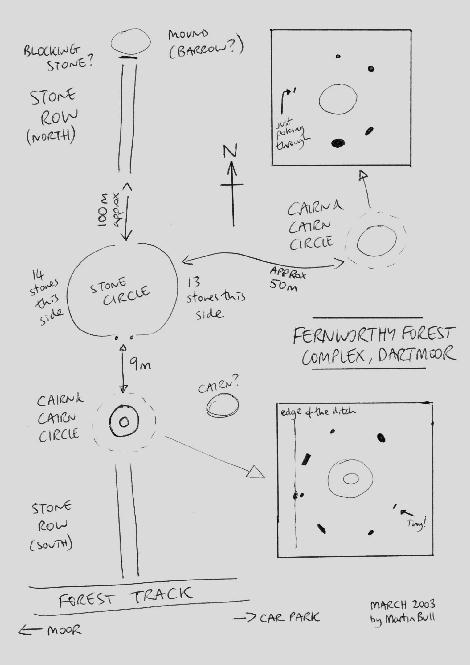
In a stroke of genius I booked another week in Cornwall for the week the clocks change, and a week of stunning weather! It is early April and Bodmin Moor is tinder dry. Just before I arrived there had been several small fires in North Cornwall nd the day I left there was a large gorse fire at the other end of Cornwall (on the Lizard peninsula). I stopped off in Dartmoor on the way, the sun was blazing and Fernworthy forest was so peaceful. Although it’s usually only the circle that is talked about Fernworthy is one of these ‘complexs’ with a stone circle , two cairns and cairn circles, two stone rows, and possible others. I was so taken in that I began to think I was an archaeologist for a day and soon I will have to unleash diagrams onto this fantastic TMA site! The south side of the forest also has a stone row. And a brisk walk onto the moor brings you to the Greywethers, a restored and stunning double circle. I also tried to find the Heath Stone on the way out. Does visiting ancient sites get much better than today? On Sunday I went to the St Breock Downs area, checking out the St Breock Wind Farm Barrow, the colossal Men Gurta Menhir, and peering at the St. Breock Downs Menhir. I then moved south to the China Clay country (sounds like a theme park) to find the moved Menevagar / Roche Longstone and the huge Hensbarrow - this is the highest natural point in the area and the views back across the valley are stunning, with the St Breock Downs wind farm clearly visible. However, if you ignore the nice bit of the view you could just as easily think you are sitting on the moon as the clay works surround you. To round off a pretty lazy day I visited the two sites closest to where I was staying – Headon Barrow and Warbstow Bury, the later being quite stunning and the best-preserved hill slope fort in Cornwall. On Monday I pleasured myself (steady on!) with a trip to the St.Austell Brewery - http://www.staustellbrewery.co.uk - and onto Mevagissey for sarnies on the harbour. I had forgotten my maps so instead of heading off for some yomping on Bodmin Moor I had to pull Plan B out, which was a visit to The County Museum in Truro - http://www.royalcornwallmuseum.org.uk - I knew that the famed cup marked stone from the Tregiffian Burial Chamber was there, as was a copy of the Rillaton Cup, and other things. There is a huge amount to see and as they are a registered charity it is £4 well spent (and please fill out a Gift Aid form, so they can reclaim your tax!) Tuesday led me on a huge barrow hunt, including the massive Tich Barrow, one of the Starapark Barrows, the Advent Triple Barrow (a rarity), and the Crowdy Reservoir Barrow and then several wind swept hours in the Roughtor area, including the Showery Tor ring cairn and cheesewring, and the Showery Tor Embanked Avenue, the Showery Tor Downs Cairn, Roughtor Slopes Cairn and three possible standing stones in the area. In an action packed day I also went to the fascinating King Arthur’s Hall, , the nearby King Arthur's Downs Stone Circles, the Casehill Cairn, and explored around the area; expect a diagram soon! On the way home I had a quick stop at Helsbury Castle. Like it or loathe it I thought The Museum of Witchcraft - http://www.museumofwitchcraft.com - was worth a visit so the next day I went to see it in Boscastle’s picturesque harbour. I was glad to see the Museum asking people not to have fires, leave rubbish or ‘inappropriate offerings’ at ancient sites. Later I visited three great cliff castle’s close by – Willabury Cliff Castle (Boscastle) plus the fascinating ‘stitch’ system of agriculture on Forrabury Common, Willabury Cliff Castle (Tintagel), and Tintagel itself. I also saw the curious Rocky Valley Rock Carvings but I’m even less convinced now. I had a quick search for Ugworthy Barrows (actually over the border in Devon) and the rare Woolley Long Barrow. I really don’t seem to have got the hang of these ‘holidays’ have I? Not much resting going on, so I only went out on the moors late on Thursday, and spent some of Friday re-reading one of favourite books on the beach at Crackington Haven (‘Life and Times of Michael K’ by J.M.Coetzee if anyone is interested). So several hours on Thursday were spent on Fox Tor & East Moor and in the Leskernick area of Bodmin Moor. Two totally different environments in one way (the former gorsey and brown, the later green but scarred and pitted like the moon) separated by the A30 but both full of ancient sites, and continued finds. East Moor includes the Fox Tor Stone Row (apparently), the East Moor Stone Row, and possible Menhir / Stone setting, and the Nine Stones of Altarnun. The Leskernick area is still being explored and new things still being found. My few hours included Leskernick Stone Row, a cairn near the stone row, Leskernick Stone Circel (Northern), Leskernick Stone Circle (South), the Leskernick ‘Quoit’, the Cairns on the summit of The Beacon, and a possible Kerbed Cairn and Barrow Cemetery on The Beacon This post appears as part of the weblog entry Another Kernow Week
|
 Posted by pure joy
6th April 2003ce |
| The Northern stone rows seem out of alignment with the circle and are incomplete, the Northernmost stones apart from the blocking stone appearing to be missing. Still a nice site though and quite easily accessible. |
Posted by Lard 22nd April 2002ce |
Miscellaneous |
|
|
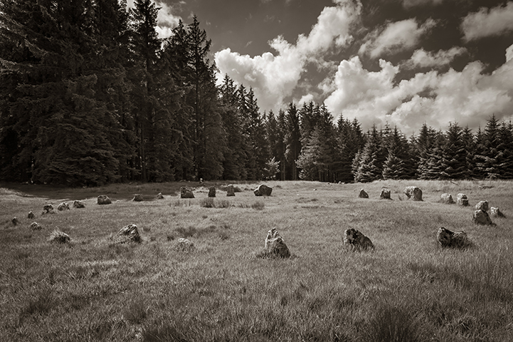
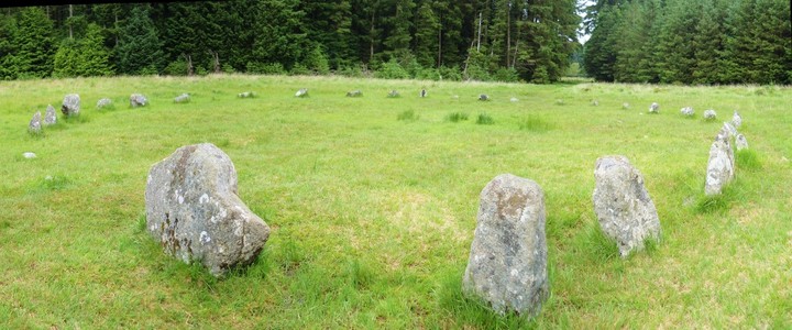
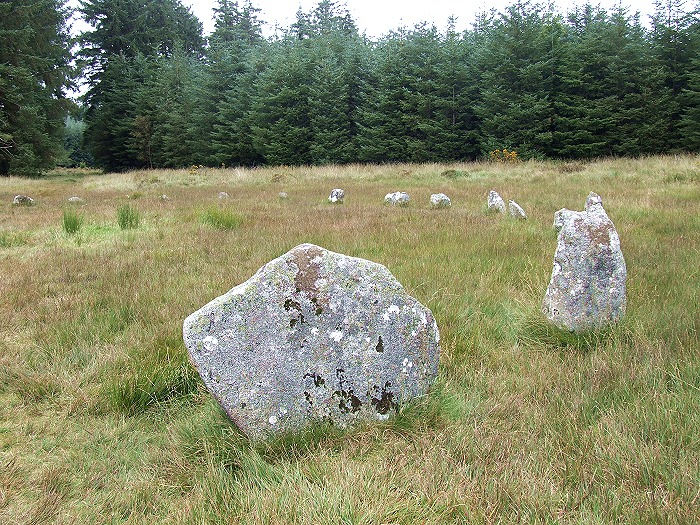
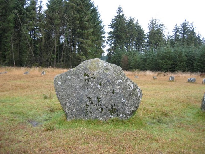
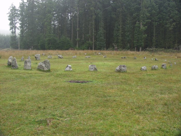
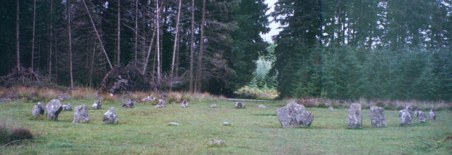
Details of stone circle on Pastscape (SX 65488412) Fernworthy Circle (NAT) Stone Circle (NR). (1) Fernworthy stone circle is 64 1/2 feet in internal diameter and is very nearly complete, with 26 stones standing and only four missing. The circle was examined in 1898 but no finds were made except charcoal on the surface of the 'growan'. No trace of any burials. (2) Diameter 19.5., the circle now comprises 27 stones, the largest being 1.1m high. (3) SX 64108320. This cairn is situated in a shallow natural depresion on a gentle S-facing slope at 475m OD. The area has been extensively disturbed by peat cutting activity. It is a turf-covered stony mound 5m in diameter and a maximum 0.5m high. There is no evidence of a kerb or excavation pit. (5) Centred SX 65488412 in a clearing in Fernworthy Forest is a stone circle currently containing 29 stones (excluding trigger stones). It has an internal diameter of 19.3m (N to S) by 18.6m and is circular for all but an inward-turning kink in the N edge. The stones average between 0.6m and 0.5m tall, although they are generally larger in the S side, being up to 1.1m tall. Two stones not depicted by Butler (7) or Worth (2) visible in the S edge nearly flush with the ground. Around the stones in the SE, SW and NW areas of the circle are substantial erosion hollows with channels leading away under the adjacent trees. Inside the circle are a number of amorphous hollows, mounds and scarps which are probably associated with the excavation work of 1897 which found little except for charcoal over the surface of the bedrock. (6) |
 Posted by Chance
12th April 2016ce |
Links |
|
Some photos and video of Fernworthy circle. . |
 Posted by wickerman
10th July 2012ce |
Fernworthy Panorama360 degree panorama from the centre of the circle. |
 Posted by Chris Collyer
28th September 2008ce |
Megalithic Walks siteStone circle and stone row on Dartmoor 3 photos and guide to site |
Posted by phil 13th January 2002ce Edited 21st July 2005ce |