The Modern Antiquarian
Log in
|
Register
Home
Latest Posts
Forums
Maps
Help
Browse Sites
News
Blog
Contributors
The Books
Select
-
Belgium
Denmark
Eire
France
Germany
Greece
Italy
The Netherlands
Norway
Portugal
Republic of Malta
Spain
Sweden
Switzerland
United Kingdom
Scotland
Perth and Kinross
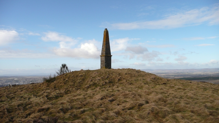
Murrayshall Hill
Cairn(s)
Murrayshall Hill (Cairn(s)) on The Modern Antiquarian, the UK & Ireland's most popular megalithic community website. 2 images, plus information on many more ancient sites nearby and across the UK & Ireland.
Image © thelonious
Nearest Town:
Perth (5km SW)
OS Ref (GB):
NO1647225358 /
Sheets: 53, 58
Latitude:
56° 24' 46.83" N
Longitude:
3° 21' 14.16" W
Added by
thelonious
Images (2)
0 discussions
Start a topic
Show |
Hide
Web searches for Murrayshall Hill
Flickr
Google
Google Images
MAGIC
The Megalithic Portal
Bing
Stone Pages
Streetmap.co.uk
Wikipedia
Show map
(inline Google Map)
- Sites within 20 km -
-
Arnbathie (0.77km NE) (6 posts)
Law Hill (0.78km NE) (8 posts)
Law Hill (1.05km NE) (9 posts)
Kilspindie (1.17km E) (11 posts)
Kilspindie (1.17km E) (3 posts)
Kilspindie (1.17km E) (17 posts)
Bonhard (1.5km WNW) (15 posts)
Shien Hill (1.59km NE) (9 posts)
Deuchny Wood (2.09km SW) (5 posts)
Shianbank (2.22km NW) (13 posts)
Pole Hill (3.15km ENE) (8 posts)
Goddens (3.41km ENE) (6 posts)
Sandy Road Scone (3.42km W) (8 posts)
Evelick (3.47km ENE) (12 posts)
Murrary Royal Standing Stone (3.93km WSW) (3 posts)
Beal Hill (4.41km ENE) (5 posts)
Over Durdie (4.49km E) (11 posts)
Inchyra (4.84km ESE) (9 posts)
St.Martins (4.89km NW) (4 posts)
Dove Craig (5.29km NNW) (4 posts)
St Madoes Stone Row (5.41km ESE) (7 posts)
Blairhall (5.52km W) (1 post)
Brownies Knowe (5.55km NNW) (8 posts)
Ardgilzean Cottage (5.64km WNW) (10 posts)
Hawk Stane (5.7km ESE) (8 posts)
St Martins (5.85km NNW) (7 posts)
Moredun Top (6.07km SSW) (2 posts)
Williamston (6.09km NW) (9 posts)
Witch's Stone (6.26km NNW) (6 posts)
Williamston (6.32km NW) (2 posts)
Craigclowan (6.37km SW) (4 posts)
Moncreiffe Hill (6.4km SW) (1 post)
Rait Farm (6.47km ENE) (4 posts)
Blackfaulds Stone Circle (6.63km NW) (19 posts)
Fingask (6.64km ENE) (12 posts)
Rait (6.64km ENE) (10 posts)
Moncrieffe (6.69km SSW) (4 posts)
Moncrieffe House (6.69km SSW) (8 posts)
Grey Stane (7km E) (5 posts)
Hilton Of Moncrieffe (7.09km SW) (3 posts)
Druids Seat Stone Circle (7.13km WNW) (29 posts)
Bandirran Circle West (7.15km NE) (30 posts)
Bandirran Circle East (7.2km NE) (20 posts)
Craigmakerran (7.26km NW) (2 posts)
Denmarkfield / King's Stone (7.32km W) (9 posts)
Bandirran 4-poster (7.37km NE) (4 posts)
Wolfhill (7.61km NW) (8 posts)
Denmarkfield Farm (7.67km W) (2 posts)
Dunsinnan Hill (7.87km NE) (12 posts)
Colen Wood Stone Circle (7.92km WNW) (18 posts)
Callarfountain (8.17km WSW) (3 posts)
The Long Man's Grave (8.31km NE) (12 posts)
Balmalcolm (8.57km NE) (4 posts)
Perth Western Edge (8.7km WSW) (5 posts)
Pitlandie (9.01km W) (6 posts)
Little Dunsinane (9.2km NE) (5 posts)
Abernethy Den (9.52km SE) (10 posts)
Huntingtower (9.55km WSW) (1 post)
Overbenchil Farm (9.74km WNW) (9 posts)
East Whitefield (9.76km N) (2 posts)
Inchmartine (9.85km ENE) (5 posts)
Macbeth's Law (9.85km NNE) (4 posts)
Newbigging (9.87km NNW) (5 posts)
King's Seat (10.08km NE) (4 posts)
Gellybank Stone Row (10.15km W) (11 posts)
Castle Law (Abernethy) (10.2km SSE) (13 posts)
Gallow Hill Wood (10.63km N) (5 posts)
Macduff's Cross (10.64km ESE) (9 posts)
Black Cairn (10.68km ESE) (12 posts)
Clatchchard Craig (10.89km ESE) (3 posts)
Balholmie (11.05km NNW) (9 posts)
Moneydie (11.08km W) (18 posts)
Dron Hill (11.25km SSW) (4 posts)
Loak (11.6km WNW) (7 posts)
Loak (11.74km WNW) (7 posts)
Castle Law (Forgandenny) (11.83km SW) (4 posts)
Lyndoch East Stone (13.06km W) (4 posts)
Glenduckie (13.12km E) (11 posts)
Lyndoch middle stone (13.43km W) (4 posts)
Lyndoch west stones (13.98km W) (4 posts)
Forteviot (14.05km SW) (7 posts)
Dron Hill (14.09km ENE) (21 posts)
Falcon Stone (14.11km ENE) (11 posts)
Hill Of Dores (14.15km NE) (13 posts)
Pitsundry (14.16km WNW) (6 posts)
Druids Park (Murthly Hospital) (14.58km NW) (8 posts)
Carmichael Cottages Cursus (14.88km ENE) (1 post)
Norman's Law (14.89km E) (15 posts)
Pitcur Souterrain (14.9km NE) (15 posts)
Cleaven Dyke (14.92km N) (16 posts)
Abbots Deuglie (15.37km SSW) (1 post)
Market Knowe (15.58km ENE) (10 posts)
Creich Manse (15.97km E) (20 posts)
West Blair (16.06km SSW) (5 posts)
Green Craig (16.21km E) (11 posts)
Bachilton (16.26km WSW) (1 post)
Knowehead (16.41km NNE) (9 posts)
Caputh (16.48km NW) (9 posts)
Easter Nether Urquhart (16.56km SSE) (5 posts)
Collessie Farm (16.85km ESE) (10 posts)
Muirheadstone (16.88km WNW) (11 posts)
Murthly Castle (17.01km WNW) (7 posts)
Leadketty (17.07km WSW) (0 posts)
Glendelvine Cairn (17.1km NW) (6 posts)
Glendelvine House (17.17km NW) (9 posts)
Witch's Stone (17.22km WNW) (11 posts)
Staredam (17.24km WNW) (18 posts)
Leadketty (17.37km WSW) (1 post)
Collessie (17.63km ESE) (3 posts)
Dunning (17.9km SW) (12 posts)
High Keillor Farm (18.01km NE) (20 posts)
Green Hill (18.07km E) (9 posts)
Mains Of Fordie (18.09km NW) (14 posts)
Cairn Muir (18.2km NW) (6 posts)
Hurly Hawkins (18.25km ENE) (4 posts)
Leys of Marlee (18.42km NNW) (37 posts)
Tullybeagles Moor (18.59km W) (7 posts)
Gallowstone (18.74km E) (1 post)
Coultra Hill (18.74km E) (6 posts)
Devil's Stone (Invergowrie) (18.92km ENE) (9 posts)
West Lomond Hill (18.97km SSE) (19 posts)
East Cult Standing Stones (19.1km WNW) (27 posts)
Craig Obney (19.13km WNW) (5 posts)
Fir Hillock (19.14km N) (6 posts)
Birnam Hill (19.15km WNW) (10 posts)
Braco (19.18km W) (4 posts)
Kinpurnie (19.18km NE) (6 posts)
Maiden Castle (Lomonds) (19.31km SE) (14 posts)
West Mains (19.37km NE) (7 posts)
Milton of Rattray Cursus (19.58km N) (1 post)
Kinloch (19.61km NNW) (8 posts)
Gray Stone (19.63km SW) (6 posts)
Battle Law (19.63km E) (4 posts)
The Kor Stone (19.65km W) (5 posts)
Newtyle Two Poster (19.73km WNW) (13 posts)
Balgarthno (19.74km ENE) (33 posts)
Arthurstone (19.97km NNE) (1 post)
- Facilities within 20 km -
-
Tayside Hotel (Hotel: 9.7 km NW)
The Famous Bein Inn (Pub: 12 km S)
Ballathie House Hotel (Hotel: 12.1 km NNW)
Meikleour Hotel (Pub: 14.5 km NNW)
Glenfarg Hotel (Hotel: 15.1 km S)
Kirkstyle Inn (Pub: 18.1 km SW)
Dunning Hotel (Hotel: 18.2 km SW)
- Add -
-
Add news
Add an image
Add fieldnotes
Add folklore
Add miscellaneous
Add a link
-
Add a site
Add a nearby facility
Add an alternative name/spelling
Images
(click to view fullsize)
Add an image
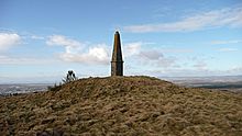 Image © thelonious