Marvellously, you can read online or download for free, two brand new books about the site that analyse Chantel Conneller, Nicky Milner and Barry Taylor's excavations between 2003-15.
Volume one is called 'A persistent place in a changing world' and the second is 'Studies in technology, subsistence and environment'.
The site was occupied / used for about 800 years. The first people there deposited worked wood, articulated animal bone and flint tools into the lake. The next period was the main phase of occupation, in which large timber platforms were made at the lake's edge, and items were still being deposited into it. And in the last phase both the dry land and the wetland margins were still being used, "often for craft activities," and making axes and tools - and the oldest known British Mesolithic art - a shale bead - was found there. I love a shale bead, me. They're in chapter 33 of the second volume. The famous antler frontlets are in chapter 26.
|
Old people believe that at regular times during the year the fairies hold important horse fairs. One special 'fairy' man near this village relates how he was ordered to get up in the middle of the night to change horses from Mount Mary near the town of Ballygo down to Rathcroghan near Tulsk.
Hundred of horses with small 'mineen' riders galloped down across the country in the moonlight November Eve.
The great grandfather of the present blacksmith had his instructions to be always ready on Halloween night to put on shoes on the little travellers' horses.
One night he was dozing by the fire when a shout + tramp of horses wakened him. He was going to lift the horse's hind foot, when he noticed the animal had only three feet. "I can't shoe this horse" he said. "It's all right we will help you" said a score of little riders. The work was done and away went the fairy host, galloping like the wind, on their way to Rathcroghan for the great horse fair. From the 1930s 'Schools Collection' of folklore, now being digitised at Duchas.ie. It seems like another one of those half-told tales (the three footed horse) where you are supposed to be in the know already and instinctively understand what it means from all the other three-legged animal tales you know. I'll have to work on it.
|
Elf Stones:- The following account is given by Michael Fitzsimons, age 75, Doon, Tierworker, Bailieboro.
Elf stones were supposed to fall out of the air with a shower of rain. They are a grayish white colour nearly like a sea-shell. If any of them fell on a cow she would get into a sickness called Paralysis. It was said that people would cure the cow of the sickness if they got nine of these elf-stones in a porringer or any other suitable vessel and go to a stream bordering two counties before the sun rises in the morning and get some of the river water in the vessel along with the elf-stones and bring them home and go round the sick cow three times.
While doing so keep praying some special prayers. Before very long the cow would be better.
A man named Philip Carry, Doon, Tierworker, Bailieboro, Co. Meath had two sets of Elf-stones and all the people round this locality used to go to Philip Carry's for the elf stones when they had cows sick. Elf stones are kept at certain houses yet. The nine stones were in the Prophet Malcolmson's house. Then a man named Andrew Clarke Lisnasanna, Kingscourt, Co. Cavan got them to make the cure and another named Connor Muldoon, Cordoy, Kingscourt got them from Clarke to make the cure and they remain in that house yet.
When they are given away to make the cure the man that gave them away could not take them back to keep, unless to make the cure or they would be no good. They are kept at some houses yet. It was a good cure for paralysis.
When cows were struck with those stones they were said to be "elf shot". The hair would stand on them and they would be unable to move until the cure was made. From the Schools' Collection of folklore, made in the 1930s, and now being transcribed at Duchas.ie. Elf stones can also be interpreted as Neolithic arrow heads. But you never know.
|
  
|
There's an article on this massive stone by Serge Cassen and colleagues in this month's edition of the Cambridge Archaeological Journal (v28:2, 259-281 - 'The 'historiated' Neolithic stele of Saint-Samson-sur-Rance'). Eight meters'-worth sticks out of the ground at 42 degrees, and the four sides are aligned to the points of the compass. It's made of granite, the nearest source of which is 4km away.
The researchers recently used various lighting and 3D techniques to highlight the carvings on the stone, and conclude that those on the different sides represent different aspects of the world (viz. an empty boat (east), human artefacts (south), wild animals (west) and domesticated animals (north). Whether you agree with this analysis is up to you… the depictions look a bit ambiguous to me but what do I know. There are also 100 cupmarks (none on the east face).
They talk about the folklore too, which is mostly from a 1902 article by Lucie de Villers ('Le Menhir de Saint-Samson pres Dinan' in Revue des Traditions Populaires 17(6)):
The vein of quartz diagonally crossing the stone was supposed to be from the devil's whip, or perhaps from the chains he used to try to drag it into hell. The devil wanted to use the stone as a key to open up hell (so he could pop some sinners in there) - but Saint-Samson and his pal Saint-Michel chased him away before he'd completed his evil plan.
There are various beliefs about a flood in Armorica: Ys is a legendary city in the bay of Douarnenez - it was submerged when the key of the dyke protecting the city was stolen from the king. In the 19th century local people said the stele was the key to the sea, and if the stone was removed, the sea would flood across the whole of France.
In other legends the stone is only one of three keys to the sea (one of the others was stolen by an evil woman from Breton in cohoots with the devil, and the third was kept in a distant country - or perhaps the other two were lost, or in the hands of a witch). The reason the stone is at such an angle is because the devil tried to take it away but didn't succeed. If someone dares to turn the stone, the sea will bubble out from under it and cause more trouble than Noah's flood.
One of the alternative names for the stone is 'Pierre Bonde' - bonde is the same word as the wooden bung used to seal a barrel.
Despite all this connection to the sea, the stone is about 20km from the sea and 55m above it. It's suggested in the article that it's at the point of the river where the maximum extent of the tidal wave would have been in the Neolithic, and that points to the reason for its location.
|
I've not been up here for a very long time. Perhaps you're guilty of the same sort of thing - tending to overlook local places for new and exciting ones that are further away. But my sister and I found this excellent, complete with its air of weirdness. (A couple of vaguely peculiar things happened while we were here, although normal people wouldn't have given them a second thought. Maybe you find more weirdness when you're expecting it.)
It was exposed here but dry, and we could see great globs of low dark cloud moving across the landscape, pouring on less fortunate places. There's a 360 degree view - quite uncommon round here where lots of high spots are joined onto bigger bits of land like Salisbury Plain.
We were mostly here for the wildlife (we saw kites, a yellowhammer and oil beetles among other things) and specifically for the snails. It got hilariously competitive as we hunched over little chalky scrapes out of the wind, my sister triumphantly brandishing a tiny shell a few millimetres high - What?! Why haven't I got that one... (Competitive snailing eh, whatever next. But it's amazing how much variety there is, and because they're empty, you don't have to feel too guilty about collecting a few shells.)
On reflection I suppose we climbed the hill in a spiralling way like the shape of a shell. Much nicer than the more ghastly straight-up approach - it's precipitously steep in places. Most of the hill is so windswept and open, but the quarried area on the south is such a strange muddle of lumps and bumps. They loom up over you and it feels strangely enclosed and surprisingly claustrophobic. But the quarried area doesn't take up the amount of space that you expect from the carpark. It's only a little area really.
There are other earthworks too -the Iron Age ridge that circles the hill for one. It doesn't feel very usefully defensive but maybe the slope would be enough to put most people off storming up. I did start to wonder, did anyone ever really live up here? The top isn't particularly big or flat like nearby Scratchbury and Battlesbury. You can imagine people in their huts there but not so much here. Yet Martin and Dave from the National Trust did find some here with their resistivity experiments.
This strange isolated hill advertises itself from all sorts of spots for miles around. You'd want to know who was in charge of it. And who was buried in the Bronze age barrows on top? It's funny to sit in their lea and have the same sort of view that people have seen for thousands of years (if you ignore industrial agriculture). There's also a linear dyke that's said to cut across one of the barrows, dating it at least a bit.
We also walked down the amazing sunken lane on the hill's south (part of the Mid-Wiltshire Way) - recommended as another numinous spot.
|
The Tolmen of Constantine.
Mr. R. Edmonds called attention to this rock - the finest of its kind in Britain; it is ten time as large as the Logan Rock, which is estimated at 70 tons. The Tolmen (or holed-stone) is about 33 feet long, 19 broad, and 15 high. Of this fine relic, Mr. Edmonds said that unless a subscription be immediately set on foot to purchase the rock, together with that portion of the cairn which it covers, there is reason to fear that the fragments will soon form part of the national buildings now in progress at Chatham or Plymouth, as the granite quarries have already reached within a few feet of it. If the three Royal Societies of Cornwall were to interest themselves in the preservation of this noble monument and effect its purchase, the comparatively small sum thus expended would confer honour on all its contributors, but if it were suffered to perish, the disgrace to our native county would never be effaced. A warning against complacency when it comes to believing other people will look after the best interests of our monuments in their landscape. In the Royal Cornwall Gazette, 12th October 1849.
|
For the young antiquary. Series IV.
Hole stones are more abundant in Ireland than is generally supposed, and we have some fine examples in the North. The best I know is "The Holestone," Doagh, County Antrim, a very massive galean of basalt, with a bevelled hole through the upper part, bevelled on both sides so that the actual hole or centre of the stone is not large. Whatver may have been the original use to which this stone was put, one legend says criminals were chained to it, others that it was a contract stone, contracts of various kinds being ratified by joining hands through the hole. In later days it seems to have been - and possibly still is - used by engaged couples to ratify their engagement. It stood when I last saw it very close to the edge of a quarry that was rapidly approaching it. I trust that it may not follow other fine prehistoric memorials of the same area destroyed through the ignorance or apathy of the farmers on whose land those memorials stood. [...] Robert J Welch encouraging the youth in the Northern Whig, 20th March 1924.
|
The line of the Devil's Ditch and the county boundary runs pretty straight towards Park House (still a hotel, on the old line of the A303), which sounds like where Park Gate must have been, and presumably the stone. So it makes you wonder if this huge stone did have some significance. I can't see it marked on a map so not sure quite where it was - it's hard to tell which direction the 'narrow lane' was heading (possibly NW back along the boundary but who knows). Now the area is carved up with roads so I fear it won't be there any longer. But it sounds impressively big.The county boundary at Clarendon Hill, about a mile west of North Tidworth, turns towards the south along an old landmark called the "Devil's Ditch," on the western side of Beacon Hill, down to Park House. The burial mounds called barrows abound in the direction of Ambresbury; and no wonder, for we are approaching what was once the fashionable burying-ground of eminent Ancient Britons.
[...] At Park Gate, on the county boundary, on the road between Andover and Amesbury, there is, or was, in a field abutting on a narrow lane leading from the roadside inn, a flat stone, of large dimensions, 11ft. long, 12ft. in breadth, and 5ft. in thickness. One of the many traditions about Stonehenge is that the great Sarsens came from Andover, and this Park Gate stone, in order to help the tradition, is quoted as having been on its way thither but abandoned. From 'Notes on the Border of Wilts and Hants' by the Rev. Canon J.E. Jackson, in WANHM v21, 1883.
|
The following letter from "The Proprietor of Stonehenge" appeared in the Times, of Thursday last:-
In a recent impression of the Times "A Visitor to Stonehenge" complains of the general damage done in thirty years past, and of particular damage done on the day of his visit. I believe no one of our old monuments has suffered less during the period first mentioned, and, considering the thousands who annually visit it, I think the public deserve much credit for the very little damage done.
On inquiry I find that about a fortnight ago an individual of the mechanic class brought a large sledgehammer, and, notwithstanding the remonstrances of a person who is usually at the stones holding horses, persisted in breaking the corners of two of the fallen stones. This is the only recent damage I can find, after a careful inspection. If I knew his name and place of residence, I should assuredly try what the law could do in such a case of wilful mischief; but, speaking generally, and judging from results, I believe an appeal to the public interest in such monuments and to the good feeling so generally entertained is the best preservative.
In the few cases of attempted mischief I am bound to say that the operative class are not those principally implicated. A member of the professional classes was one evening found, in the interests of science, as he asserted, endeavouring to ascertain the depth of the foundations. He apologised in the county paper, and the matter dropped.
A respectable paterfamilias, who arrived in a well-appointed barouche, was heard by a relative of mine asking for "the hammer and the chisel." On being requested to desist from the intended operation, the answer was, "And who the deuce are you, Sir?" On being told the petitioner claimed to be the proprietor of the threatened institution, he declared he had always believed it "public property."
In another instance three young men, being found on the top of two of the standing stones, stated they were about to carry off a piece of what is called the Sarsen stone for a relative of one of them, who was a distinguished archaeologist. On my writing to that gentleman, depracating a renewal of his relative's visits with such intentions, he assured me no relative of his would be guilty of such an act, adding, as a further assurance, that the act was unnecessary, as he already possessed a piece of the stone in question; he added, "given him by a friend."
I think I can re-assure the public mind as to the question, and I may surely ask those who take an interest in it, when they see attempts of the sort, to offer one of those good-natured remonstrances which will carry weight with the offender, and are sure to enlist the sympathy and assistance of the great body of bystanders. Re-reported in the Salisbury and Winchester Journal, 23rd September 1871. I love the dry retelling of the anecdotes. And the final paragraph surely still holds as good advice today.
|
A few weeks since, a labourer employed in digging flints, near Hollingbury Castle (the ancient earthwork or camp on the summit of the hill between Brighton and Stanmer), discovered an interesting group of antiquities, placed very superficially in a slight excavation on the chalk rock. It consisted of a brass instrument, called a celt; a nearly circular ornament, spirally fluted, and having two rings placed loosely on the extremities, and four armillae or bracelets for the wrist, of a very peculiar shape. All these ornaments are composed of a metallic substance, which, from the appearance of those parts where the green patina, with which they are encrusted, has been removed, must have originally posessed a lustre but little inferior to burnished gold. They are clearly either of Roman or Anglo-Roman origin, and probably were buried on or near the site of interment of the individual to whom they belonged. From the Salisbury and Winchester Journal, 7th February 1825. It seems they're in the British Museum now: I found their photo here. Not quite so flash as a gold torc but I like them. They've got a very modern minimal look about them.
|
That night the three heroes [Laegaire, Conall and Cuchulain] were given as good a feast as before, but they were put to eat it in a room by themselves. When night came on, three enchanted monsters, with the shape of cats, were let out from the cave that was in the hill of the Sidhe at Cruachan, to attack them.
When Conall and Laegaire saw them, they got up into the rafters, leaving their food after them, and there they stayed till morning. Cuchulain did not leave his place, but when one of the monsters came to attack him, he gave a blow of his sword at its head; but the sword slipped off as if from a stone.
Then the monster stayed quiet, and Cuchulain sat there through the night watching it. With the break of day the cats were gone, and Ailell came in and saw what way the heroes were. "Are you not satisfied to give the Championship to Cuchulain, after this?" he said. "We are not," said Conall and Laegaire; "it is not against beasts we are used to fight, but against men."
...
There was at Cruachan the Hill of the Sidhe, or, as some called it, the Cave of Cruachan. It was there Midhir brought Etain one time, and it is there the people of the Sidhe lived; but it is seldom any living person had the power to see them.
It is out of that hill a flock of white birds came one time, and everything they touched in all Ireland withered up, until at last the men of Ulster killed them with their slings. And another time enchanted pigs came out of the hill, and in every place they trod, neither corn nor grass nor leaf would sprout before the end of seven years, and no sort of weapon would wound them. But if they were counted in any place, or if the people so much as tried to count them, they would not stop in that place, but they would go on to another. But however often the people of the country tried to count them, no two people could ever make out the one number. From Lady Gregory's 'Cuchulain of Muirthemne' (1902), page 68 and page 148.
|
Mr John S. Leitch, Longformacus, told the party of an old tradition about the stones and said that this was that "Auld Nick" had undertaken to build a cauld at Kelso across the Tweed. As he could not get the material at Kelso, he had gone to Dunbar for it, and there he had filled his mittens. As he had flown back from Dunbar one of his mittens had rubbed against the top of a hill with the result that the mitten burst and the contents fell where they now saw the stones. So angry had "Auld Nick" been that he had refused to build a cauld at Kelso.
Mr Leitch went on to tell the company that during the last war a German bomber had dropped 27 bombs close behind the stones, killing three sheep. He had told an old man in the village about this and the old man's reply was that it was not the first time things had been dropped at Byrecleuch. (Laughter.) From a trip of 70 members of the Berwickshire Naturalists' Club, reported in the Berwick Advertiser, 26th May 1949. I didn't know the word but a cauld is a weir or dam on a river.
|
On the way back to the carriages [from the Boscawen-Un circle] the party visited Careg-Tol, a fine pile of granite rocks not far from the Circle, commanding an extensive view. Thereon are some shallow rock basins, the outline resembling a human foot, and which, being of superhuman size, are locally called giant's or devil's footprints. From a report of an excursion of the Penzance Natural History and Antiquarian Society, in the Cornubian and Redruth Times, 3rd September 1869.
|
Some stoney folklore from the hill (not unfamiliar from elsewhere):On a farm called Craggs, near Sabden, on the sloping side of Pendle, is a mass of sandstone rocks, which have fallen down from the scar above. On one side of the big stones are two marks side by side, about two feet six inches long, and about six inches wide. They resemble gigantic footmarks, and are said to be those of the Devil. However, when he alighted on the stone he must have crossed his legs, for the left footprint is on the right side of the stone. The outline of this foot is quite perfect, but the other is ill-formed. This is accounted for by the well known fact that the Devil has a club foot.
About a mile from the "Devil's Footprints," and on the crest of the hill above Ashendean Clough, not far from the Well Springs public-house, are a quantity of stones scattered about on the ground, locally known as "The Apronful." Nearly in the centre of them is a hollow in the ground, and the writer is inclined to think that these stones were formerly built into a rude wall round the hollow as a base for a beacon fire, and that they have since been scattered about as they now lie.
The local legend however, is as follows. One day the Devil was coming with an apronful of stones for the purpose of knocking down Clitheroe Castle. He stepped from Hambledon Hill on to the side of Pendle, where he left the footmarks on Cragg's Farm before alluded to. His next step was to the Apronful. Here being in view of the Castle, he took one of the stones and threw it towards Clitheroe; but just as he was in the act of doing so, his 'brat string' broke, and all the stones he was carrying were tumbled on to the ground. [The stone he was throwing] fell short of the mark, and may now be seen, with the marks of his fingers on it, in a field above Pendleton.
The breaking of the apron-string is a very common incident in folk stories. It occurs in connection with the building by the Devil of a bridge near Kirkby Lonsdale; and in an Ormskirk legend of the Devil. From a piece in the Burnley News, 8th January 1916.
|
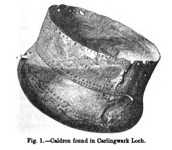
From volume 7 of the Proceedings of the Society of Antiquaries of Scotland (1870).December 1866. The Donations to the Library and Museum were as follows, and thanks were voted to the Donors:-
1. By Samuel Gordon Esq. and J T Blackley, Esq, Castle-Douglas, Kirkcudbrightshire.
Large Caldron, formed of very thin plates of yellow bronze, the bottom being formed of one large sheet, and the sides of various smaller portions, all riveted together. It is patched in various places with additional bronze plates of various sizes riveted on. The caldron measures 26 inches in diameter across the mouth, the sides being straight, but bulging out to the extent of 1 inch above the rounded and flattened bottom. Part of the circumference of the mouth, where the handle had been attached, has been torn away.
The caldron was dredged up by the donors from Carlingwark Loch, Kirkcudbright, and contained
an adze, 7 inches in length, 2 inches across the face (Plate 1 fig. 1);
three axe-heads, measuring from 4 1/2 to 5 1/2 inches in length, and 2 to 2 1/2 inches across the face (figs. 2, 3, 4) - each of these tools have small projections of the metal on each side of the half-hole;
four small picks or hammers, with narrow extremities, from 6 to 7 1/4 inches in length (fig. 5) and apparently a broken half of another hammer-head, 4 inches in length;
hammer-head with flattened ends (fig. 6);
portion of a small saw, 6 1/2 inches, with blade 1 inch in breadth - a portion of the wooden handle remains riveted to the blade (fig. 7);
portions of a fine cut saw, 2 1/2 inches in length and 1 1/2 inch in breadth;
nine portions of double-edged blades, with pointed extremities resembling sword points, from 2 1/2 to 6 inches in length, and from 1 1/2 to 2 inches in breadth;
nails of various lengths, one with a large head, with a cross marked on each side (fig. 8);
small slender chisel, 5 inches in length, 3/4 of an inch across the face; portion of another chisel; three punches, 4 3/4 to 5 3/8 inches in length (fig. 9);
four split bats with eyes (figs. 10 and 11);
two large holdfasts; six hooks, varying in size from 2 1/2 inches to 5 inches in length (fig. 12);
iron buckle (fig. 13);
two handles with loops, apparently the handles of a bucket, one rudely ornamented with punched parallel lines (figs. 14, 15, 16);
wooden handle (fig. 17);
an iron implement (fig. 18);
iron tripod or ring, with three feet, apparently for supporting a pot (fig. 19);
and an iron frame, with numerous bars, and having two feet, the other two apparently awanting, the whole resembling a rude gridiron; five pieces of iron handles, one measuring 5 3/4 inches in length by 1/4 of an inch in breadth, has a loop at each extremity (fig. 20);
snaffle horse-bit, with check-ring 3 inches in diameter (fig. 21);
file, 9 3/4 inches in length and 1 inch in breadth; various scraps of iron plates; portions of iron hoops or bands perforated with holes. That's a lot of stuff. I started to regret typing the list. There are a few more things listed but I got the impression they were other stuff being donated by the two men mentioned, rather than stuff found in the caudron. There's a photo of the cauldron here on the NMS database, along with all its miscellaneous contents.
|

|
Just to warn you, if you see a horse here. Just leave it alone.The Seven Herds of Sallachie and the Water-horse.
Lang syne, when men, and flocks, and herds were plenty in Sutherland, there were seven herds watching their flocks by Loch Shin, and it was evening. They all quarrelled among the others. Said one herd to the other, "That is my father's horse." "No, it is my father's horse": and they fell to fighting (for the horse looked different to each of them). The first jumped up. "There is room for two," said the second, and jumped up also. The others were angry.
"It is a bonny horse, too," said a girl that came by, when they were all up but one. And she patted its shining skin, but her hand stuck to it.
"Oh! Annach," cried her brother,"will ye die with the others, or want your hand?" "Oh! take off the hand and let us run."
So he took the hand off, and they two ran home, and the seven herds of Sallachie were never seen again.
Mr Young, Lairg. It's a bit ghastly isn't it, with hands being chopped off and magic water horses willfully drowning people. Excellent.
From Miss Dempster's "The Folk-lore of Sutherlandshire" in The Folk-Lore Journal volume 6.
|
From Mr Borlase's article in The Cornish Telegraph, 27th April 1864:Having obtained the kind consent of William Rashleigh, Esq. of Menabilly, Cornwall (to whom the property belongs), I visited Chapel Uny on the 10th of August, 1863. The ground above and around was intersected by the low dilapidated walls of an ancient British village somewhat similar to, but in no way so perfect as, those at Chysauster (where there is also a cave), at Bossullow Crellas, and other places in the neighbourhood.
In two places the ground had fallen in, disclosing in the one a portion of the side of a circular subterranean building; and in the other a deep and dark cavity. It appears that for the last century the cave has remained in exactly the same state as it is at present. Traditions of the place aver that it terminates beneath a huge 'cairn' [where] treasure is concealed; and also that it leads to the fortification of Caer Bran, which is about a quarter of a mile distant: but the former of these curious traditions has already proved to be incorrect. I guess he's suggesting the fogou at Carn Euny connects with this spot.
|
I've found Grinsell's source about the Gappergennies:There was another barrow, over which the road to Fontmel now runs, by Folly Hanging Gate, near Washer's Pit. In this lonely place, till within living memory, strange sounds were made by creatures in the air called Gappergennies, or however else the name may be spelt.* Of the nature of these sounds I have not been able to learn anything, ecept that they could be successfully imitated by human lips.
When, perhaps fifty years ago, a metalled road was made to Fontmel instead of the old cart-track, this barrow, which lay close to the old road and on the line of the new one, was dug up, and the bones it contained buried in the churchyard. As there is no entry of the fact in the register, this was no doubt done without the burial service.
On the down, by the roadside, a cross had always been kept cut, opposite the barrow. This has been neglected since the reinterment; and since then, also, the strange sounds have not been heard.
The low mound and the cross on the turf are well remembered. On the common below Sandpits Field is a line of small barrows, which seem to have been opened at some remote date. No exploration of any of these Ashmore remains has in recent times been attempted...
* Otherwise called Gabbygammies. The late Mr Stephen Hall, of the Manor Farm, who had often heard the sounds, thought they were made by badgers. (E.H.) God what a let down. But also in the book:With the hollow below the Folly, where the road to Fontmel crosses the bottom, a legend is connected, well known in Ashmore, into which the name of the Barbers has been introduced, though the story must be far older than their time. It runs that a Squire Barber, or perhaps his daughter, for the tale is variously told, was warned in a dream on three successive nights, or else three times on the same night, that some one was in distress at Washer's Pit.
The person warned woke the household and asked for a volunteer to go down to the place. No one would venture, except the cook. Her master gave her his best hunter for the ride, and she went forth to find a lady in white hanging by her hair from an ash tree over the well, now closed, at Washer's Pit. She released the victim and carried her back on the horse to Ashmore [...]
Connected with the same ground as this legend and that about the barrow at Folly Hanging Gate, is another of a woman in white, who has been seen and felt brushing by them, within the last fifty years, by travellers between Spinney's Pond and Washer's Pit. I have heard it connected with the barrow, but the true form of that story is the Gappergennies; and the affair at Washer's Pit ended too happily to generate a ghost. This must be some third and independent legend.
It is curious that in a parish full, as Ashmore is, of dark and lonely places, no other neighbourhood than these few yards on the road to Fontmel should have its story. Pp 3 and 20 in Ashmore, Co. Dorset: A History of the Parish, by E W Watson, 1890.
Washer's Pit is actually the other side of Ashmore and nowhere near the longbarrow. But as an example of excellent local barrow folklore I hope this is the best place to record it.
|
Doubtless there is not a single jot of evidence for the following. But if you want to experience a thrill about those savage Ancient Britons then it's just the thing. Also, it's always nice to involve the Phoenicians in some way, don't you find.Some months since a query was asked in these columns as to the derivation, &c., of the word 'toot'. Much interesting information was given, but I don't think the derivation as given below was hinted at. This derivation I found in a book published in 1888, written by Theodore Compton, and called "Winscombe Sketches of Rural Life and Scenery."
Speaking of Cleeve Toot, "a remarkable crag or conical rock, the top of which can be seen above the Brockley Woods from the railway between Nailsea and Yatton," we are informed that this is supposed to be one of the Toot Hills used by the Ancient Britons for sacrifices to the Celtic god Teutas. Also there are several other Toothills in different parts of England, as well as other places supposed to be named from the same deity - Tottenham, Tutbury, Tooting, to which might possibly be added Chewton Mendip and Chew Magna, near which is the Druid Temple of Stanton Drew. The Celtic deity Teutas was identified with the [Roman] god Mercurius, the Greek Hermes, the Egyptian Thoth and the Phoenician Tautus. Finally, reference is made to the human sacrifices which used to be made on Cleeve Toot. -- F.F. In the Notes and Queries section of the Taunton Courier, 13th May 1936.
|
Derham, or Durham, is remarkable for certain huge Ramparts and Trenches, which shew, that it has antiently been the Scene of some Military Action; and here Ceaulin the Saxon, in a bloody Engagement, slew three British Princes, and by that Means dispossessed the Britons from that Part of the Country: 'Tis likewise noted for many fine Springs, which supply the Boyd. From The Natural History of England, volume 1, by Benjamin Martin (1759).
|
In the parish of Glantane formerly called Kilshannig, and six miles distant from Mallow is the place called Carrigcleena or Cleena's Rock. It is a townland and gets its name from the conspicuous rampart of rock that is situated in it and pointed out as the entrance to the dwelling place of Cliodhna, the Fairy Queen. Many are the stories told about Cliodhna around this locality.
Cliodhna's father was called the Red Druid and generally regarded as the last of the druids. He, it is said, was made prince of the territory which now embraces the town of Fermoy and its neighbourhood by the reigning King of Munster, whose life he had saved in battle when the latter was fighting with the High King of Ireland. On this occasion the Red Druid raised a great storm by his magical powers and compelled the High King's forces to retire from the engagement.
Cliodhna and her sister Aeibhill are famous figures in Irish fairy lore, and their period is believed to have been the middle of the eighth century. Cliodhna, the elder daughter of the Red Druid, seems to have inherited strange powers like her father. She fell in love with a young chieftain named O'Kieffe, who was lord of the territory adjoining that of her father. But, unfortunately, the younger sister, Aeibhill, also became enamoured of the same chieftain, and this aroused the wrath of Cliodhna, who was of a proud, passionate and haughty disposition. Full of jealousy, Cliodhna resolved to make her own union with the chieftain secure at all costs, and to this end, as the story goes, she changed her sister Aeibhill with a magic wand into a beautiful white cat, after the latter had refused to renounce her affection for the man to whom Cliodhna was betrothed.
When the Red Druid and his wife learned of the fate of their daughter, they both took the sad news so much to heart that they died shortly afterwards. The Druid was buried on the summit of a hill about three miles from Rathcormac since called Carn Thierna, and his wife was laid to rest near Glanworth.
(N.B.: We read of some interesting finds recently, including the bones of a woman, in the great dolmen called Leaba Chaillighe, near Glanworth, Co. Cork. Were these the remains of the Red Druid's wife, who, according to tradition was buried beneath this dolmen!)
But to return to the story, Cliodhna married the chieftain O'Kieffe, and all went well until he came to hear of her sister's fate at her hands. They became estranged as a result and Cliodhna retired to an underground palace, having been discarded by her husband. This palace is, according to many accounts in the townland above mentioned viz., Carrigcleena, so called by the natives "the Rock." This palace was long believed by the peasantry to be the scene of the general assembly of the fairies throughout Ireland, where they met to consider important matters relative to their race.
Aeibhill, after being enchanted by her sister took up residence, as local tradition goes, in an underground palace also, situated at Castlecor, near Kanturk, Co. Cork, beneath an old cave hidden by trees. It is also said that she resumes her natural form for a week each year at midsummer, appearing as a beautiful maiden of twenty. She was regarded as the guardian spirit of the Dalcassian race, and Queen of the Fairies of North Munster. The King of Ireland, Brian Boru, is reported as saying on the evening of the Battle Clontarf, that Aeibhill came to him the previous night and told him he should fall that day.
The last account of Cliodhna, as told by local residents around Carrigcleena, runs as follows:
Situated about two miles north of Carrigcleena, and on the road to Mallow, is a cross-roads called Pindy's Cross, Pindy being a corruption of pente, Greek for five. There are five roads branching off at these cross-roads. It seems there was a smithy or forge at this spot long ago, no trace of which is to be found now. Cliodhna, mounted on a white horse, appeared before the forge and asked the smith to put a shoe on one of horse's legs. This the smith promptly did. When leaving Cliodhna is reported to have called the smith's attention to a clump of bracken that was quite green-looking and growing nearby. She said that she was leaving the place, but did not disclose where she was going, and gave the smith a sign whether she would return again or not. The sign was the green bracken. If, on the following day, the bracken was green as usual, she would return, but on the other hand, if the bracken was withered, then never again would she come back. The smith next day saw the bracken shrivelled up and withered, and Cliodhna has never been heard of since. Written by Donal Archdeacon, a teacher at Carrigcleena More, for the 1930s Schools Collection of folklore. You can see the original document at Duchas.ie.
|
From the School's Collection of the 1930s, now being transcribed at Duchas.ie.In the town-land of Labbycally where I live there is a Cromlach or ancient grave called the "Hag's Bed" It is said that an old hag and her husband lived there with their five children. It is supposed that they were all buried there. There is one big grave and five small ones.
In ones of the stones there is a dent. The story that is told is that the Hag made an attempt to strike her husband with a hatchet and that she hit the rock. The dent is to be seen up to this day. The river Funcheon flows near the Hag's Bed and a big rock is to be seen in the middle of the river. The old saying is that the hag and her husband had a fight. He ran to the river and she flung the rock after him and killed him.
Told to Peggy Foley by Mrs Roche, age 68.
The townland of Labbycally, Glanworth, Co Cork is situated about 4 miles north of Fermoy on the road to Glanworth village. Near the road on the land now owned by Mr Quinlan there is a well known cromlech which is called the Hags Bed". An old hag and husband are said to have lived there long ago. People say that it was the hag that lifted the huge flat stone out of the river Funcheon and put it up on supports. There is a big underground tunnel running from the Hag's Bed to the river. One day the hag and her husband quarrelled and she is said to have flung a big stone at him. The stone landed in the Funcheon and is still there. There are marks on it it which are said to be the print of the hag's fingers.
Told to John Collins by Michael Collins, age 47.
|
Leitrim weirdness (and some casual destruction of archaeology), collected by the local teacher from Terence Geoghegan, a 55 year old farmer.In the townland of Mullaghgarve in the year 1936, I was working on a Relief Scheme, and I came on a mound of stones. There were big long limestone flags, standing up on end along the sides of the mound and at both ends. Outside the flags there were piles of stones of various sizes and shapes - some of them would weigh about 2 cwt. Inside the same standing flags there were a number of broken flags which appeared to me to have been a cover that reached from the standing flags on one side to those on the opposite side. Of the standing flags there was one on the western end higher than the others. Outside that flag we got ashes similar to that, that comes from a turf fire.
Between the standing flags or stones were stones of various sizes which we removed for road metal. At a depth of about three or three and a half feet we came on a number of what we thought, in the gathering darkness of the evening, were human bones, and part of a skull. I brought home a number of the bones with me to examine them, as I heard there was a Druid buried there.
This happened in the month of December. Just as we were quitting work a friend invited me to his house to spend a few hours there. I went to it and brought the bag containing the bones with me. The people of the locality saw lights coming from and going to the house while I was in it but I knew nothing of this whatever.
I left the house at 11 or 11.30 p.m. and when I was a short distance from it I saw a number of lights in front of me, and as I was making my way to the road which I was approaching at right angles, I saw more lights farther away from me coming down the road. They were like so many lanterns, and I hurried to overtake those in front of me, as I thought they might be young lads going to a dance, and that their company would help to shorten the road home. I did not succeed as they went off on the bye-road where I was working during the day. I then waited for the other lights that were still coming on, and when they came to the by-road they went down it too. I then thought it strange that I was within 12 feet of each group of lights, and that I heard neither talking nor walking. There were about 7 or 8 lights in all.
I then continued on home, and nothing strange occurred till I was about 400 yards from my home. Suddenly a small light sprang up in front of me, and it was about a foot up from the ground. I first thought it was a glow-worm, and I stood to find out what had it raised so high above the ground. I put my hand under it, and raised it up on my hand. I felt no heat from it, or any kind of feeling of weight or softness. I at once shook it off my hand, and away it sailed through the air, increasing in size, and it went in the direction of the road where I was working, that is, in the direction of the mound. It went as straight as an arrow for there, but as a hill intervened between me and the mound I cannot say where it went when it crossed the hill.
As soon as I got to the house (my home) the roosters started to crow louder than I ever heard them before. I then went out to see was there anything wrong with the cattle in the byre, and to find out what was disturbing the birds, but I noticed nothing unusual. I then returned to the house, and with candle light I examined the bones which I had brought with me, and I concluded they were those of a human being.
As long as I was awake the cocks kept up the crowing, but as I was tired I fell asleep soon after going to bed, but my wife told me they kept up the din till daylight. She did not know that I had any bones home with me till next morning, for if she did I am sure she would make me put them outside the house. From the Schools Collection, being digitised at Duchas.
|
One time the landlord Danny Hewittson of the Lough Veagh estate was erecting a mill in his yard and he sent some of his men to the old abbey in Gartan for a stone which he thought suitable for putting under the upright shaft. This stone was round in shape and there was a hollow in the centre. It was supposed to have been used by Colmcille for holding holy water in his abbey.
When the mill was complete he told the men to bring the horses along and [?] it but all the horses on the estate could not drive it. They removed the stone and put it back in the abbey and substituted another stone. The mill then worked perfectly. Sounds a bit like a bullaun stone to me. St Columkille / Colmcille certainly had a lot of stones.
From the Losad / Losset volume of The Schools' Collection, transcribed online at Duchas.ie. I can't make out the [?] though.
|
I'm not saying Mr Rh and I are unsociable, but we do seem to tend to head for the emptiest reaches of beyond on holiday these days. And the beach at Bostadh does feel like quite a long way from anywhere. You need to leave the Scottish mainland for Skye, catch the ferry to Lewis, drive up north and over the bridge to the island of Great Bernera, then aim for the furthest tip of that. It should probably be called the Outer Outer Hebrides if you ask me.
I can promise you pale sand and properly blue water that wouldn't look out of place in the Caribbean (it's just a bit draughtier). It was nice to just sit and watch the local birdlife flying around and bobbing about. But if you walk to the back of the beach you'll spot a thatched mound, its roof held on by long ropes weighted with holed stones. It's a recreation of the houses that once stood here in the Iron Age - a number were revealed in the 1990s when a storm blew away some of the dunes.
You must cross a little moat (which unfortunately isn't putting off the rabbits who are eating the roof - they've got the sense to use the bridge like you do) and descend into the sheltered low doorway. Then ducking down (even I had to duck) you enter the house.
It's absolutely pitch black, and although you can hear a welcoming voice telling you all will come clear in a moment, and inviting you to sit just there (or somewhere thereabouts) - well it's just as though you've gone blind. But gradually your eyes adjust, and in the meantime you can listen to the superb soft Lewissian lilt of the lovely and knowledgeable woman who is the house's curator. Eventually you'll believe her that it's even possible to read a book in this dim light.
I thought I might like to live in a house like this, cosily out of the draught, with my strongly-scented peat fire burning, doing a bit of weaving.
I thoroughly recommend you visit, it feels like time travel.
|
A warning in case you were thinking of doing some laundry in the sea loch to the north of the Dun. Although conceivably it could refer to somewhere similarly named - phonetic attempts in English to name Gaelic places are still pretty confusing 300 years later.There are several Springs and Fountains of curious Effects [on Lewis]; such as that at Loch-Carlvay, that never whitens Linen, which hath often been try'd by the Inhabitants. From Martin Martin's 'Description of the Western Isles of Scotland' (second edition of 1716).
|
... One comes unexpectedly to Lud Church entrance at which, on payment of threepence, with a reduction for quantity, in this case numbers, one passes through a rough wooden gate to the right and down worn steps into a long narrow chasm whose rocky sides vary between 30 and 50 feet in height.
The dank, damp air, moss-grown boulders, and air of desolation, produce an eerie atmosphere which is borne out by the history of this place. A ship's figurehead fixed high up in the rocks and known as the statue of Alice de Lud-Auk, or our lady of Lud, but in spite of the owners collecting dues from visitors this statue now lies merely a shapeless piece of wood on the floor of the defile.
So a part of history lies uncared for and some of us would wish that something had been done to preserve this most interesting feature.
Lud Church is also known as Traffords Leap because one Squire Trafford of Swythamley Hall, whilst hunting one day found himself on the brink of the chasm without opportunity of turning his horse and to save his life he made his horse leap across. Several hounds were killed as they failed to clear the cleft and fell upon the rocks below.
A popular superstition or legend avers that the redoubtable Friar Tuck here conducted services for Robin Hood and his merry men and it is certain that Lud Church has afforded sanctuary for outlaws and criminals.
It is also established that some of the Lollards held services and meetings for worship here during the persecutions of the reign of Henry V. At the upper end of the cleft is a cave which was used for those services of the Lollards, whose leader was Walter de Lud-Auk, and the story goes that soldiers surprised them during one of their meetings and attempted to fight their way into the cave.
Whilst the soldiers were being held at bay by Montair - a member of the sect - the rest tried to escape from the other end of the cleft. In this engagement, Alice, the beautiful daughter of Walter de Lud-Auk was shot by a bolt from a crossbow aimed by a soldier at Montair. Montair escaped to France and the rest of the Lollards were arrested. Walter de Lud-Auk died in prison.
The wooden effigy which used to commemorate Alice is said to have been the figurehead from a ship named "Swythamley" after the estate in which Lud Church is situated, which was taken after the ship was wrecked and erected in Lud Church in 1860.
Still another story claims that the figure represents Alice Lud who was shot by soldiers when they surprised a meeting of Luddites. Alice Lud was the leader of a band who met in Lud Church to make their decisions.
There have been attempts to explore the cave in which the meetings were held but falling stones have prevented any definite conclusion. The cave is estimated to have been 200 yards long and 100 yards deep.
[...] And just one more story, about Bonny Prince Charlie. The Prince had become separated from his army owing to a delay at Manchester, and was hurrying across the moors to meet his army which was expected to be below the Roches. Darkness had fallen when he reached Swythamley and so he and his bodyguard decided to sleep in Lud Church. Waking early next morning Prince Charlie was surprised to find a beautiful girl watching him. The girl ran away as soon as she saw he had woken but, when later he made a thorough search of the cleft, he discovered to his great delight that she was Flora MacDonald who had disguised herself as a member of his bodyguard in order to be near him. From a piece in the Sheffield Independent, 30th September 1938.TO PLEASURE PARTIES.
Visitors to Buxton are respectfully informed that E. ROBINSON, Dane Cottage, Quarnford, has permission from the owner, P. Brocklehurst, Esq. of Swithamley Hall, to SHOW LUDCHURCH. Refreshments may be had at the Cottage.
Buxton Advertiser. 8th September 1875. LUDCHURCH. Tourists can be provided (Sundays excepted) with TEA, &c.; also with Milk, at the Manor Farm, Quarnford. Good Stabling.
Buxton Advertiser. 25th September 1880.
|

|
Dun Dornghil, erroneously called Dornadilla, is represented at the termination of this Chapter. It was, in the memory of man, about thirty feet high, but is now much dilapidated. Not a stone of this fabric "is moulded by a hammer, nor is there any fog or other material used to fill up the interstices among the stone; yet the stones are most artfully laid together, seem to exclude the air, and have been piled with great mathematical exactness."
The following verse concerning it, is repeated by the inhabitants.
Dun Dornghil Mac Duiff
Or an taobh ri meira don strha
Scheht mille o manir
Er an rod a racha na fir do Gholen.
Translation.
The Dun of Dornghiall, son of Duff,
Built on the side of the strath next to Rea,
Seven miles from the ocean,
And in the way by which the warriors travel to Caithness.*
* Rev. A. Pope, in Archaeologia, v. From 'The Scottish Gael; or, Celtic manners, as preserved among the Highlanders' by James Logan (first published 1831).
|

|
Notes Archaeological, Geological, etc. on Beanley Moor and the vicinity of Kemmer Lough. From the MSS of George Tate. In the History of the Berwickshire Naturalists Club, volume 23, 1890.
He mentions the carved stones, and also the 'detached blocks of stones which are usually covered over with lichens, and hoary with age, are here called "Grey Mares".'
|
VANDALISM.
To the Editor of Saunders's News-Letter.
SIR- Yesterday, being in the neighbourhood of Glencullen, with two friends, we went to inspect a cromlech between that place and Ballyedmonduff named "Giant's Grave" in the Ordnance map. Imagine our surprise and indignation at finding only its site; it had recently been literally quarried away, perhaps, for some purpose for which any other stones would have answered just as well, and this too, at no great distance from quarries now being worked.
Archaeologists should learn from such cases as this, which unfortunately are only too common, the importance of never passing one of these structures without taking a sketch, or better still, if possible, a photograph, and measurements of it. It is much to be regretted that landed proprietors do not adopt proper precautions for the preservation of these interesting relics of remote antiquity from wanton destruction.
I am, sir, your obedient servant, W.H.S. Westropp, MRIA.
Blackrock, October 11, 1867. In Saunders's News-Letter, 15th October 1867.
|

|
After a little delay, the remainder of the journey was accomplished to the next regular stoppage, at a place called "The Piper's Stones." here, again, Lord Walter Fitzgerald had some information prepared for the members, which he read out at the spot. He explained that the existing objects of antiquarian interest lying a short distance to the south-west of Ballymore-Eustace are three in number. In the first place there are the large boulders of graite placed in a circle 31ft. in diameter in the townland of Broadleas Commons, called "The Piper's Stones." They are now 29 in number. Formerly they made up a complete circle of closely placed boulders, though now there are large gaps in the ring showing where in times past many had been broken up and carried away for building purposes.
At a place called Athgreney, there is another similar circle of stones, and in the Deerpark, near Blessington, formerly there was a third one, each called "The Piper's Stones," but this latter was demolished years ago for building purposes.
[...] The name, "Piper's Stones," was often applied to this class of monument, and must have its origin in some now forgotten legend. The only explanation the old people give for the name is that bagpipe music, played by the "good people" or fairies, is still occasionally heard at the spot.
A quarter of a mile to the north-east of "The Piper's Stones" are the remains of a Pagan sepulchral moat, called Knockshee, meaning "the fairy hill." Little of it is now left, three-quarters of it having been demolished years ago, probably by some farmers, for the purpose of top-dressing the adjoining lands.
[...] Half a mile to the north-west of "The Piper's Stones" is a prostrate granite monolith, known as "The Long Stone." It formerly stood in a small rath-like enclosure now levelled, and which was thrown down in the year 1836. From the Kildare Archaeological Society's annual excursion reported in the Warder and Dublin Weekly Mail, 22nd September 1900.
|
The farmers' sons and daughters of the parishes surrounding Eggardon Hill held their annual private picnic on the hill on Whit-Monday, and were joined by a number of friends from a distance. The Askerswell band was in attendance, and dancing commenced shortly after four o'clock. During the evening a great number of persons went on the top of the hill to enjoy the extensive scenery. About six o'clock they all sat down to an excellent tea, and as evening drew on the band played almost without ceasing, and dancing was kept up with great spirit. Through the kindness of the Misses Toleman, of Witherstone, and Misses Wrixton, of King's, there was an abundance of refreshments. The party broke up about 11 o'clock, and left the hill cheering and congratulating each other upon their evening's enjoyment. Fun on the hill reported in the 20th June edition of the Bridport News, 1868.
|
Somewhere in the vicinity of this site is or was a holy well and a bullaun stone:St Patrick, the great local saint, is commemorated at the present day by a holy well and "knee" situated in the field (locally known as the Street Park) lying west of the school-house. It was usual for an old resident (in the barracks) to make daily pilgrimages to the well. Some of the older residents believed that St. Patrick left the impress of his knee on a rock not far from the well. However, it is quite possible that the "knee" was a mixing place for cattle medicines. It was also usual for sufferers to drop some coins, pins or trifles into the knee. Superstition had it that the ailment would be relieved in this manner. If anyone should take any of these offerings out of the knee, he should be afflicted by warts. From information recorded for the Schools Collection of Irish folklore in the 1930s, online at Duchas.ie.
The information for the site on the Historic Environment Viewer says that there are exposed blocks of limestone visible in places in the bank of the barrow here. The local landowner pointed out that major drainage operations had taken place here over the years, so large parts of the ground were previously marshy or fully flooded, immediately to NE and E of the barrow. The holy well and bullaun are said to be about 400m to its east.
|
There is a field near my home on Mrs Joe McGlelland's farm in Duffcastle, a large stone standing on four smaller ones. It is supposed to be an ancient druid's altar. It has been told that long ago two men dug under these stones and unearthed one of the smaller pillars in search of gold. When they went back to their home they found that the healthy baby they had left in the cradle was now a sickly child. It seemed to have changed in appearance too. It was said that they had done wrong and the change in the child was their punishment. This child lived for years but never grew any bigger.
In Mr John Magovern's field just at Duffcastle crossroads there is a long stone standing upright.
There are five marks on it supposed to represent the fingermarks of some ancient warrior.
There are some strokes and dots on the bottom of the stone. It is supposed that this is Ogham writing.
There are many forts near my home but there is not much known about them. Recounted by James Tweedle for the Schools' Collection of Irish folklore in the 1930s. Digitised at Duchas.ie.
|
There is a cromlech in Byrne's field on Fieldstown Hill. The field is called Lios Dubh. Fionn Mac Cumhaill is supposed to be buried there. The cromlech is on the top of the hill. There are some stones standing upright in the ground and a large flat stone on the top of them. The stones are almost covered with clay and the place is overgrown with briars. Within the grave are bones. Recounted by James Winters for the 1930s Schools' Collection of folklore in Ireland. Online at Duchas.ie.
|
Another name for this Cromlech is "Lopa-Erma." It is said that this name was got from the giant that put it up.
Under the cross stones of the cromlech there is said to be stone steps for a long way down in the ground and it is said to be closed up by the chieftain O'Kelly some years ago. From Charles Fuery, a 60 year old local farmer, recorded for the Schools' Collection of Irish folklore in the 1930s. Online at Duchas.ie
|
Legend of Fiddler's Hill
Does Warham Discovery Prove Old Legend True.
Is the old legend of Fiddler's Hill, Warham, true?
What appears to be surprising confirmation of it has been brought to light by Norfolk County Council men working on the roads. They have discovered in a mound at the crossing of the Wighton and Stiffkey road and the Binham and Warham road the skeletons of a man and a dog.
For generations the cross-roads have been known as Fiddler's Hill because of the old folk story of the fiddler. Centuries ago there was a secret passage joining Walsingham Abbey to Binham Priory. One day a fiddler and his dog, runs the legend, attempted to walk from the Abbey to the Priory by way of the old secret tunnel. Their progress was followed by some friends above ground, for as he walked, the fiddler played. The strains of the music were plainly heard slowly moving away from Walsingham towards Fiddler's Hill. Then they ceased. The fiddler and his dog were never seen again, but mysterious music, it is sometimes heard at midnight.
The bones have been handed over to the police, who took them to Dr. Hicks, of Wells, for examination. Later they may be seen by an anthropologist. From the Thetford and Watton Times, 15th April 1933.
|

|
Beacon Fire- Mr. Langham, of "Needless Inn," informs me that he well remembers that thirty-four years ago there stood, on the highest point of Beacon, an erection of rude and ancient masonry, about six feet high, of a round form, and having in its centre a cavity about a yard deep and a yard in diameter, the sides of which were very thickly covered with burnt pitch. This, he says, had all the appearance of having been used for holding the beacon fires. He remembers, too, that at that period, the entrenchments were much more visible than they are now [...]
History and Antiquities of Charnwood Forest, T.R. Potter, 1842, p48.
Beacon Hill. - Not satisfied with my single opinion of these extraordinary remains, I requested Mr. Lester, a highly intelligent farmer and surveyor, who lives at the foot of Beacon, to examine them. He was perfectly astonished. Though long resident, almost upon the spot, and aware of the remains described as lying on the south-west side of the hill, it had never occurred to him that there were others. "Often," says he," as I have crossed that wonderful hill, and always with the feeling that it was a charmed spot, I have been either so occupied with the distant prospects, or so circumscribed in my immediate view by the inequalities of the surface, that I have never before once noticed the most remarkable fortifications to which you have directed me."
Potter, p49.
Wake at Nanpantan. - The Annual Wake, now kept on Nanpantan, but formerly kept on Beacon, the origin of which is lost in obscurity, may be a remnant of [a Druidical] festival.
Potter, p45. I'll take the Druidical festival with a pinch of salt, but the Beacon must have seen its fair share of revels. I totally understand the farmer not being able to look round for "inequalities of the surface" (i.e. trying not to fall over) - that often affects me. And I like his italicisation of charmed... it hints at a fairyish spot.
Collected into 'County Folk-lore: Printed extracts no. 3, Leicestershire and Rutland' by C.J. Billson (1895).
|

|

|
This hill, it has a meaning that is very important for me, but it's not rational. It's beautiful, but when you look, there's nothing there. But I'd be a fool if I didn't listen to it.
-- Alan Garner.
...I'd rather be
A Pagan suckled in a creed outworn;
So might I, standing on this pleasant lea,
Have glimpses that would make me less forlorn...
-- William Wordsworth.
Some interesting websites with landscape and fairy folklore:
http://earthworks-m.blogspot.co.uk
http://faeryfolklorist.blogspot.co.uk
|
|