From the church we walked up to the Roman encampment of "Cadbury Castle," which is most interesting. It was partially excavated in 1848, and on the previous evening we had been shown many interesting relics taken from it. The most valuable of these is a large ring of debased silver. On an intaglio of a light green antique paste is engraved an object supposed to be connected with the sacrifices of Apollo or Hercules. There are, besides, some smaller rings, some armlets, reminding one singularly of the present fashionable bangles, and making one remember that there is nothing new under the sun. Both the workmanship and design of these are singularly delicate. There were glass and enamel beads, horses' teeth, fragments of pottery, &c.
All these had been taken from a well in the centre of the camp. There has been an attempt to fill up this well, but it persistently sinks down in the centre. There is a tradition that there is an underground passage from the top of Cadbury Castle to Dolberry Hill (Killerton). Risdon gives us the following couplet:-
"If Cadbury Castle and Dolberry Hill down delved were,
Then Denshire might plow with a golden coulter and eare with a guilded sheer."
From the same source we learn "that a dragon, forsooth!" is supposed to guard these treasures.
The views from Cadbury Castle are both extensive and beautiful. The Dartmouth Tors were all plainly visible, and we saw Cawsand white with snow. Farther to the left our eyes rested on Exmouth and its Bar, and on the other side we saw the range of hills at Wellington, in Somersetshire. By 'Volo non Valeo' in the Exeter and Plymouth Gazette, 29th May 1885. Tristram Risdon wrote his 'Survey of the County of Devon' in 1632.
|
I don't understand how the traditional rhyme isn't already written here. So I don't apologise for the length of the following:[...] Folklore and science, romance and archaeology, the unlearned and the learned, have all contributed answers [to the meaning of the stones]. From the folklore of the neighbourhood we have gleaned the story of the stones which has undoubtedly proved the most popular, and which will probably be attached to them as long as they stand. Indeed it is probable that if we searched the whole of England we should not find a site in which the folklore is a more living thing.
The story is well-enough known, but here it is:--
A certain King set out to conquer all England and had arrived at the head of his forces at the hill on which Rollright stands. He had almost reached its crest when a witch who claimed the ground appeared and stopped him with the words -
Seven long strides shalt thou take and
If Long Compton thou canst see
King of England thou shalt be.
Exulting greatly, thinking his victory assured, the King called out -
Stick, stock, stone,
As King of England I'll be known.
and took the seven long strides, when, lo! there arose before him a mound of earth, which at the completion of the strides prevented him from seeing the village of Long Compton below. The witch then pronounced the doom --
As Long Compton thou canst not see,
King of England thou shalt not be,
Rise up stick, stand still stone,
For King of England thou shalt be none.
Thou and thy men hoar stones shall be,
And I myself an eldern tree.
And so it came about.
[...] The elder is abundant all around the stones and several bushes have been pointed out as that embodying the witch. If you find the right one and cut it her blood oozes out, and the stones are seen to shiver, in an endeavour to come to life, for when the witch's blood is drawn her spell is broken and the King and his army will pursue their triumphant march.
On Midsummer eve, when the elder was in bloom it was formerly the custom for people to come to the King Stone and stand in a circle. Then an elder bush near by was cut and those present have affirmed that the King moved his head. The inhabitants of the district have, however, a dread of breaking the spell, and the writer was told, not so long ago, that those of Long Compton will not burn elder sticks in their grates.
The fairies dance round the King Stone of nights. One Will Hughes, of Long Compton, now gathered to his fathers, had seen them. They were little folk, he said, like little girls to look at. His wife's mother, who had been murdered as a witch, remembered a hole in the bank out of which the fairies came, and she and her playmates had often placed a flat stone over the opening to keep them in, but it had always been turned over before the morning. Folklore and religion blend in the attitude felt towards the spot and Sir Arthur Evans tells of a labourer who always went to the stones on Good Friday, for there he would be on Holy ground.
Away to the south-east on the edge of the large field in which the circle is situated, is a rather jumbled group of five large stones, called the Whispering Knights, which are said to be five treacherous officers who had detached themselves from the King's army and were plotting treason when the spell operated. They have their own particular piece of folklore and at midnight are said to run down the hill to drink at a spring in little Rollright spinney, every night according to some, only at special seasons according to others. At dusk, it is said, you can hear them whispering to each other.
Many of the stories attached to Rollright are to be found in other parts of Europe, and it is evident that we have in them something more than local superstition, but the subject is too great to be discussed here.
Another legend says that the stones become men at midnight, join hands and dance round in a circle and in Cornwall the name "Stone Dance" is attached to such circles as Rollright, the explanation there being that they are dancers turned to stone for dancing on the Sabbath.
[...] Rollright and its kindred circles were to the prehistoric people who erected and used them, places as sacred as our cathedrals and churches are to us to-day. That it should come, as it did yesterday afternoon, under the auctioneer's hammer in a public saleroom, would have filled our ancestors, could they have foreseen and understood such a contingency, with the same kind of horror we should feel if the same auctioneers were to offer Westminster Abbey to the highest bidder. From an article in the Banbury Guardian, 30th June 1927.
|

|

|

|

|

|
To the Editor of the West Briton.
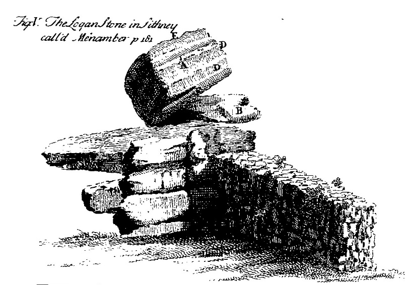
[...] In the year 1851 I was induced to visit Prospidnick village and hill, particularly the latter, by reading in Norden's Speculi Britanniae Pars, &c., 1584, an account, accompanied by an engraving, of a singular mass of rocks that is in the neighbourhood; and, on making inquiries, was informed that Men Amber was still in existence, but not in the same state as when sketched by Norden, whose description is here given verbatim:
"Mayne Amber, certain huge stones so sett and subtillye combined, not by art as I take it, but by nature, as a childe may move, the upper stone beinge of a huge bignes, with one finger, so equallie balanced it is, and the forces of menie strong men enjoyned, can do no more in moving it. It is to be imagined that theis stones were thus lefte at the general floude, when the earth was washed awaye, and the massie stones remayned, as are mightye rockes uncovered, standing upon lofty hills."
The following is from Carew, 1602:- "More certain though less wonderful, and yet for the strangeness well worth the viewing, Mayn Amber is a rock; Amber as some say signyfieth Ambrose, and a great rock the same is, advanced upon some others of a meaner size, with so equal a counterpoise, that the push of a finger will sensibly move it to and fro, but further to remove it the united forces of many shoulders over weak. Wherefore the Cornish wonder-gatherer thus describeth the same:--
"Be those thy mother Nature's work,
Or proof of Giant's might,
Worthless and ragged though thou show,
Yet art thou worth the sight.
This hugy rock one finger's force
Apparently will move,
But to remove it many strengths
Shall all like feeble prove."
Mr. Scawen, whose family had been established for a long time at Molenick, in St. Germans, tells us in his MSS., written in the latter part of the 17th century, when and by whom this logan stone was thrown down. Complaining of the mischief done by strangers, he writes:-
"Here, too, we may add what wrong another sort of strangers has done to us, especially in the civil wars, and in particular by destroying Mineamber, a famous monument, being a rock of infinite weight, which as a burden was laid upon other great stonesn; and yet so equally thereon poised up by Nature only, as a little child could instantly move it, but no one man or many remove it. This natural monument all travellers that came that way desired to behold, but in the time of Oliver's usurpation, when all monumental things became despicable, one Shrubsall, one of Oliver's heroes, then governor of Pendennis, by labour and much ado caused to be undermined and thrown down, to the great grief of the country, but to his own great glory as he thought, doing it, as he said, with a small cane in his hand. I myself have heard him boast of this act, being a prisoner then under him."
There was a tradition or prophecy, current at the time, that Mineamber, so called by Scawen, should stand as long as England had a king; its overthrow by Shrubsall seems to have been for the purpose of showing the loyal Cornish that kings were to reign no longer.
Borlase's account is as follows:-
"In the parish of Sithney stood the famous Logan stone, commonly called Men-amber; it is 11 foot long from east to west, four foot deep, wide six foot; there is no bason on the surface, but on the stone B there is one plain one. This top stone was so nicely poised that, as Mr. Seawen in his MSS. says, &c. There are some marks of the tool upon this stone, the surface, C D, being wrought into a wavy place, as in the Icon; and by its quadrangular shape I should judge it to have been dedicated to Mercury, as by a bason cut in the under stone B, I judge the stone A to be placed on the top of this karn by human art.
However that be, certain it is that the vulgar used to resort to this place at particular times of the year, and pay'd to this stone more respect than was thought becoming good christians, which was the reason that by cleaving off part of the stone B, the top stone A was lay'd along in its present reclined posture and its wonderful property of moving easily to a certain point destroyed. It was the top stone, therefore, of this Cragg which drew the common people together and raised their admiration; and I find that in the Cornish language Mea-an-bar signifies the top stone, and I do not at all doubt but that Men-amber is a corruption of Men-an-bar, and signifies nothing either relating to Ambrosius Aurelius, King of Britain, or to the Petrae Ambrosiae of the Ancients, as some learned men have thought." - Antiquities, 1754.
The letters in the last extract refer to a plan of the rock.[...]
Yours obediently,
Δ From a letter in the West Briton newspaper, 20th January 1870. He signs himself as a capital Delta. I guess the 1870 equivalent of an internet name perhaps?!
|

|

|
 
|
From inquiries that Canon Willcocks was good enough to get made for me amongst some of the oldest inhabitants of the district, it appears that the pillar-stone was always known as "the Clonegall stone." Gall is an ancient term for a pillar-stone; and "Clonegall," in the present instance, would no doubt signify "pillar-stone meadow." From Notes on a gallaun, or pillar-stone, at Leighlinbridge, County Carlow' by Sir Edmund T Bewley. In the Journal of the Royal Society of Antiquaries of Ireland v35, 1905.
|

|

|
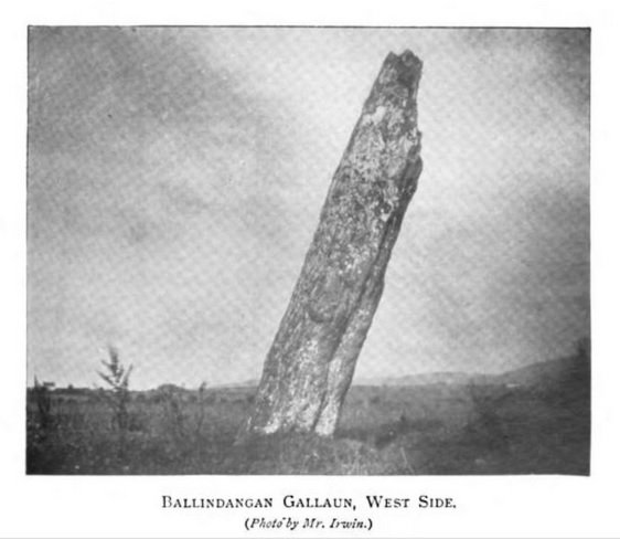
A Gallaun near Ballindangan, Co. Cork.
(By Courtenay Moore, Canon, M.A., Council Member C.H. and A.S.)
"Some months ago, a Corporal Oscroft of the Royal Engineers, who was engaged in this district, told me of the existence of the Gallaun. I went out on Saturday, July the 16th, to find it out. Stopping at the level-crossing of Ballindangan, on the Mitchelstown and Fermoy Railway, I asked an old woman at the gate-house about it; but whether it was owing to her deafness or ignorance, she could give me no information. However, help was at hand, a bright, intelligent girl, just entered on her 'teens, who overheard the conversation, and who answered to the name of Mary Kate, came forward and said she knew the stone and the way to it. Under her guidance I started off, and in about seven minutes we reached the place.
The Gallaun is a remarkable one, standing by itself in a field near the railway line. It is a monolith, ten feet nine inches in height, and five feet in superficial breadth; it is greatly scored and fissured, doubtless by the atmospheric influences and ice-action, but I could not see any human inscription on it of any kind. There is a small elder tree growing out of a cavity near the top.
The Gallaun is out of the perpendicular, probably owing to some yielding of the earth at the base, and inclines at an angle, roughly speaking, of some 12 or 20 degrees. It would be a great pity if this inclination increased, and that the stone should eventually fall.
On returning to the gate-lodge at the level crossing, I made some further enquiries, and by this time Mary Kate, my guide, was recognised by all and sundry as the proper authority. She said the Gallaun was in the town of Kilnadrow, "Spill it for him, Mary Kate, spill it for the gintleman," said her grandmother. Mary Kate accordingly "spilt it."
[...] The thickness of the stone is about one foot six inches. How much of it is under ground I have no definite idea; judging from the inclination, there is probably not very much. An old woman, who lives in the locality, informed me that a number of years ago, a man was ploughing up the field in which the Gallaun stands. The plough struck against a large flat stone, which he raised, and found under it an earthen urn containing some human bones. He replaced the urn, covered it up, and it has never been disturbed nor re-discovered since. At all events, the existence of the Ballindangan Gallaun is worth recording as a remarkable specimen of its class of pre-historic antiquities. In Historical and Topographical Notes etc...' collected by J G White (1905).
I love that these sound just like TMA fieldnotes, with chatty remarks about the difficulties of finding the stone, and the quirks of the people met in the process.
|
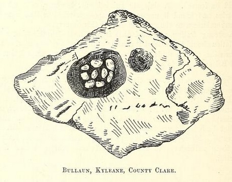
The "Wart Stone," or "Font," appears on the Ordnance Survey Map, No. 26, as "Doughnambraher Font." Thinking it very unlikely that there should be a font without a church, I came to the conclusion that there might be a bullaun at the spot marked. It is about three-quarters of a mile from Drummeen, or Barrycarroll Castle, and there is a sort of road all the way to it. We turned aside to visit the Castle, and so had to cross the fields to get to the bullaun.
We made inquiries once or twice from the inhabitants, and found out that the name of the place was Kyleane (three syllables), Killian on map; and that there was a stone there which would cure warts.
When we reached the place they pointed out, we soon found a large bullaun, of which I send a sketch. My friends thought it lay in a sort of fort, or enclosure, but I am not so sure. It is a large, flat sandstone, with one large basin in it, and something which looks like the beginning of a second. There are nine round stones in it which make part of the charm against warts: I suppose to turn them round like the Killeany stones.
We measured it as carefully as we could. The length of the stone is about 5 feet 7 inches, the width 3 feet 4 inches, while the basin is 1 foot 8 inches long, and 1 foot 3 inches wide. [...] Miss G C Stacpoole reports in the 1904 volume of the Journal of the Royal Society of Antiquaries of Ireland.
The information via the Historic Environment Viewer describes the bullaun and its stones. It says the stone is also known locally as 'Jack Baker's Well' and is made of Old Red Sandstone. It contains 'seven water-rolled 'cursing' stones'. Situated in the basin of a ballaun stone lying in the perimeter of an ecclesiastical enclosure. Seven 'fist-sized' egg-shaped water-rolled stones lie in the basin which is sometimes waterfilled and associated with the cure of warts. There were previously ten stones although the number seems to vary up and down over time. Stacpoole includes nine stones in his [her!] drawing. 'Rounds' performed here involved rubbing each stone against the afflicted part of the body and placing an offering of some sort under the bullaun. In February 1993 this practice continued. While stones of this type are generally classified as cursing stones there is no known evidence of their use for that purpose in this instance.
|

|
[The Daff Stone] is the name popularly given to a large stone which lies on a low mound of earth in a field close to the Moneydig cross-roads. It is roughly diamond-shaped, the longer diagonal reaching 7 feet, and the shorter about 4 feet. The average thickness is from 1 foot 9 inches to 2 feet.
[...] Recently, Mr. S. K. Kircker and myself, happened to be driving past the place. Noticing the stone, we stopped to have a closer look at it. To our astonishment we discovered that it was the cover-stone of a sepulchral chamber. Clearing away some dead thorn-bushes which were about, we found that the stone did not quite cover the chamber at one particular spot. We were afterwards told that the bushes were designed to prevent some young lambs, which were in the field, from falling through the opening thus formed.*
Making his way, with much difficulty, into the chamber by this "open door," Mr. Kircker, after taking some measurements, made a further discovery. He reported that one of the upright stones forming the chamber had some curious markings or scribings upon it.
I immediately secured some paper from a neighbouring shop, and he made me a rubbing, which, though not very satisfactory, showed at least that the stone was rudely decorated. [...]
The word "Daff" means in Irish 'a vat or tub'; and certainly the appearance which the chamber presents to anyone looking in justifies the name. Seven large stones form the staves of the 'cask', if I may so call it, and the cover-stone furnishes the lid.
[...] The stone marked X on the plan is the one which carries the scribings. They occur at about one-third of the height from the bottom as exposed, and cover a space 1 foot 7 inches broad by 1 foot high. On an average they are one-tenth of an inch in width. They are made up of five figures; the largest is a spear-shaped one, and runs almost across the entire space occupied. It also occurs below the other four.
The edges of the blade are formed by a series of scorings, at least five or six on the upper edge, and ten or twelve on the under one. The ends are open, and seem to curl outward - one of them certainly does. The space between these ends is filled with a smaller triangular figure, shaped like an arrow-head, with longish wings and no stem. A similar figure, but longer and sharper, occupies the top corner to the right.
The left-hand corner opposite this is taken up with a circular ornament, 5 1/2 inches in diameter. The circle is incomplete, or penannular, three inches or so of an are being wanting [sic]. There is no cup at the centre, but there are some five straight lines running downwards from the centre to the circumference, two of which are very distinct.
Though the rubbing shows only one circle, or rather partial circle, there are what seem to me faint traces of other concentric circles within this. Mr. Kircker is inclined to think that originally it was a spiral - and it may have been so; but the surface of the stone is so rough, and the scribings so faint, that it is impossible to make anything more out of the figure than what appears on the rubbing.
Between this circular figure and the point of the large spear-like one underneath the others is a fourth 'broad arrow.' Its point is in the opposite direction to that of the 'spear' and also of that which is within the open ends. In both these instances the direction of the point is determined by the shape of the space to be filled with the ornamentation.
I may add, before I leave this, that on the large stone directly opposite to the one bearing the decoration - the largest one, indeed, of all the uprights - there are a few lines scored, but there is no approach to a pattern [...] From George R Buick's article in the 1904 Journal of the Royal Society of Antiquaries of Ireland.
I love the way there's a sense of excitement as they explore the stones. And this* made me smile, I bet they found this out when the farmer came over to see what the hell they were up to, and told them off for removing the branches he'd deliberately put there.
It seems to me that there must be some quite complicated designs on the stones. And this would be very cool to see. But when I tried to find out about them on the internet, I drew a blank. The NISMR page is pretty sparse. The additional details link suggests the Official Visit in 1997 didn't notice any carvings at all. But George and his mate Mr Kircker didn't imagine them, surely? They took some rubbings of them - twice, because the first set went astray. You couldn't imagine them twice.
I know what I'd do if I lived nearby, I'd be over there with a torch and a camera.
|
 
|
 
|
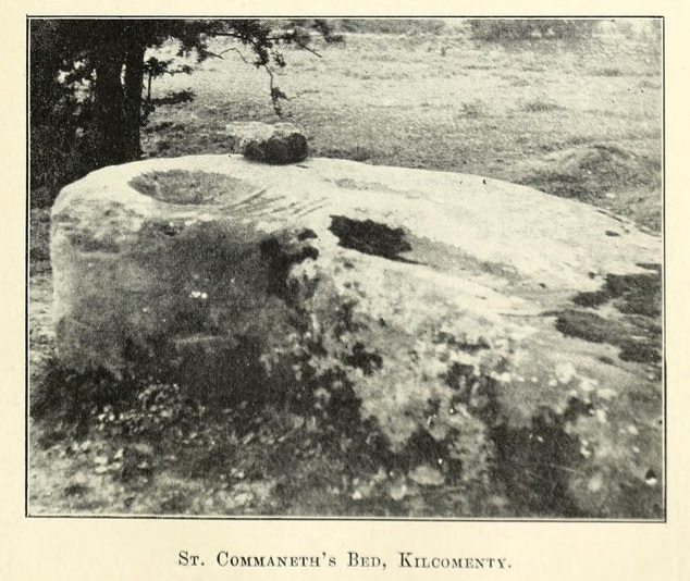
I cannot tell you how long it's taken me to track down the location of this site... variant spellings and unfamiliarity with the area did not help. But anyway it sounds superb so all this is worth the effort. I'd love to visit.
This is a naturally curious place, with a stream disappearing into the ground and reappearing: it's no wonder it's replete with folklore and Christianisation. I advise a glance at the Historic Environment Viewer map to see where the well, stream, 'bed', and bullauns all are.
This is an extract from an article on 'The antiquities of the Parish of Kilcomenty' in The Journal of the Royal Society of Antiquaries for 1904: About 30 yards east of the graveyard, a rapid stream which there issues from the ground is called St. Commaneth's Well. This stream flows from Ballinahinch, about two miles distant, and close beside the saint's bed; it is carried underground for nearly 200 yards, emerging at and forming the well; then, turning sharply by the south wall of the graveyard, it finally empties itself into the bog of Shower.
One of the legends told concerning the well is that long ago it was situated close by the stone known as St. Commaneth's Bed, but that some cattle having been accidentally allowed to sully its waters, the well in a single night moved down to its present site.
Two of the traditional trout said to frequent holy wells in Ireland are supposed to be here.
Over the well, completely shading its waters, are four ancient trees - one sallow, one whitethorn, and two ash. Those two last are in reality one enormous tree, which, near the lower part of the trunk, is divided in two, and its branches and the hollow by the well are covered with rags and votive offerings of every description, deposited by pilgrims who have made their rounds.
The summer of 1902 was exceptionally dry in North Tipperary, the month of August being phenomenally so. Springs, wells, and streams that in living memory had never been known to do so, ran dry; and St. Commaneth's Well formed no exception to the general rule, for it must be recorded that we failed to find even one drop of water within its usually brimming basin.
The rounds practised here are seven in number. Having taken seven pebbles from the stream running from the well, and having repeated the Lord's Prayer, Hail Mary!, Creed, and Gloria, the pilgrim throws one of the pebbles back into the brook, and proceeds to walk round the well. Following the course of the water for a time "sunwards," through the field south of the stream, he crosses it by a small bridge and enters the graveyard by a gate at the extremity of the south wall. Proceeding along a well-worn pathway by its north and east sides, he quits its precincts by a stile, which brings him to the well again, where he kneels and prays, and so on, until the appointed number of rounds are performed. While Mr. Westropp and I were in the cemetery, a country woman and two children "were making their rounds."
Close by the spot where the water of the stream disappears for a space under ground rests the traditional bed of the saint, lying north of the stream, and nearer to the road than the graveyard and well. It is a large irregular block of brownish sandstone, 8 feet long, and 4 feet 9 inches wide, extreme measurements, and stands about 2 1/2 to 3 feet high. The highest end is to the west, and here is a large and deep bullaun. To the west of this is a shallow, dish-like bullaun, and there are traces of two or more basins. Two sets of scorings are to be found on the stone; that nearer the top consists of six irregular broad strokes, not ogamic in character, while the set lower down consists of four slight scores. These markings are reputed to represent the impressions of the saint's ribs and hands. There's some extra folklorey information in Lives of the Irish Saints by John O'Hanlon. He mentions that the prayers at the well are good for "bodily and mental ailments."
He says of the trout: "The following is a local legend. A person of the neighbourhood, at one time, scorning to respect the well, took one of these trout home, and made an effort to roast it; nothing but blood appeared, and the rascal had to bring the trout back to the well; but from that day forward, the family has not had good luck."
He mentions of the bed: "About two hundred yards noth-east of the well, in the midst of hawthorn and alder trees, there is a great Druidic rock basin, of brown sandstone, quite unlike stone of the immediate place, which is limestone," and that the basins are "always full or half full of water."
I love the way he mixes Druids and saints. He says "There is no doubt, that the stone lay, in its present position, long before the period of the patron saint. On the conversion of the Druids, he may have used the basins for baptizing the early Christians of the place, and may have rested on it occasionally. There is nothing impossible or improbable in this presumption, and tradition may be perfectly correct."
|

|

|

|

|

|

|

|
This is a very British (i.e. a somewhat awkward, but rather endearingly so) trumpeting of the stone. The besuited Mr Chadwick is an accomplished musician in his other videos, so it must be nice for him to add Blowing Stone to his list of instruments.
I was struck by how similar the sound is to the carnyx - like those on the Gundestrup cauldron (you can hear some on this video ) - or is that just me overthinking things :)
|
Summary of Proceedings of the Bath Natural History and Antiquarian Field Club for the years 1865-6.
[...] The first [Excursion] of the season, to Wantage, the Berkshire White Horse, and Uffington, was a success in every way, due chiefly to the admirable arrangements made by Mr. Wasbrough for the transit and conveyance of the members. Under this gentleman's guidance the chief points of interest in the birth place of King Alfred were visited [...]. Leaving Wantage the members proceeded in carriages to the foot of the Downs, and essayed a blast upon the blowing stone (a mass of perforated silicious sandstone, said to have been formerly used for sounding an alarm over the neighbouring country).
The united efforts of all Bath were unable to produce a sound from the trumpet shaped hole. A native trumpeter, however, being found was more successful, and satisfied all present that when in its original place on the top of the Downs a most effective alarm could be raised.
|
The Hertfordshire HER says there is a (probable) henge here, with its entrances east and west, and a diameter of 85m. There used to be a dene hole inside it, in which Neolithic arrow heads were found. The hole was also known as being 'Jack O'Legs's Cave' (dully, it's now filled in). But you can't help thinking that a henge with built-in cave would be a rather marvellous thing.
On Jack O'Legs:
At Weston, two stones in the churchyard, 14ft. 7 inches apart, are said to be the head and foot stones of the giant Jack o' Legs, who is there buried with his body doubled up. He lived at Baldock, - where, as he walked along the street, he would look in at the first-floor windows, - and thence he shot an arrow, saying that where it fell he wished to be buried. It fell in Weston Churchyard, and, in its flight, knocked away a corner of the church tower. (Told in 1883). From 'Scraps of folklore collected by John Philipps Emslie', C.S. Burne, in 'Folklore' v26, no. 2 (June 1915).
Likewise he's mentioned in 'Handbook to Hitchin and the neighbourhood' by Charles Bishop (1875): On the Great North Road, near the village of Graveley, is a considerable elevation which goes by the name of "Jack's Hill," from its having been the scene of depradations on travellers by a noted highwayman called "Jack o' Legs." [...] In fact if you're interested, there's a whole book about this character by W.B. Gerish (1905). It suggests the cave was filled in around 1850.
|
You won't see much of a henge here now. But this comprehensive article will help you imagine the early henge here (and some of the surrounding prehistoricness) if you visit.
|
Manton Down Barrow Destroyed.
Discovery by Youth Hostel Party.
From our correspondent, Swindon, April 27.
The Long Barrow at Manton Down, near Marlborough, Wiltshire, which is believed to date from about 2,200 B.C., has been destroyed. Its destruction was discovered yesterday when a party of Youth Hostel Association members were taken to inspect the tumulus by Mr. N. Thomas, curator of Devizes Museum, and Mr. L.V. Grinsell, curator of the Department of Antiquities, City Museum, Bristol. Trees in the area had also been cleared.
Large stones which composed the barrow are scattered over a fairly wide area. Gathered around a solitary small tree are big sarsen stones at the point which was probably the burial chamber. Some now stand on edge. In a half circle from the rubble which originally composed the mound are groups of uprooted bushes and trees.
Mr. Thomas said to-day: "Mr. Grinsell and I are reporting the matter to the chief inspector of monuments at the Ministry of Works." The title of the barrow, he said, was something of a misnomer. It was, in fact, one of the shortest of the barrows, of which there are several in the locality. He put its length at about 80ft., and it would, he thought, have been about 3 ft. to 4ft. high. It was scheduled as an ancient monument. Featuring my favourite folklore icon, Mr Grinsell. From The Times, April 28th, 1953. Can you imagine their faces (or the language). The next part of the story is in another post below.
|
The Camp At Portskewett.
(From a Correspondent).
[...] Thanks to the members of the corps - about 20 in number - who, under the command of Captain Williams, proceeded to the camp on Saturday last, a sufficient number of tents had been pitched for our accommodation before our arrival en masse on Monday.
[...] There is nothing which indicates the whereabouts of the "soldiery" until one is as it were in the midst of them. The tents are completely hidden from view by the high ramparts which extend from the north-east to the south. The piece of ground enclosed within the ramparts is of a triangular form, the eastern line being formed by the waters of the Severn. Coming suddenly into a deep moat without the ramparts, one is as suddenly confronted by a sentry, marching with a soldier-like air, a guard-room, or rather a guard tent, and a number of the guard lounging about.
Immediately in front of the guard tent, there is a gap, cut right in the angle of the encampment, and looking through this the whole of the tents and their occupants within are at once visible, presenting to the visitor a lively and picturesque scene, of which, two minutes before, he could have had no perception.
[...] The weather has been glorious throughout the week, but the heat, which would be exceedingly oppressive in town, is rendered delightful here, with a stiff fresh breeze flowing across the water. Each day the men have worked and drilled with a subordination that would be creditable even to a soldier of long service, and order has been maintained night and day. Heavy gun drill has been gone into most zealously, and some good practice has been made [...]
Ghost stories are not wanting in the guard room, for one good reason. On the north-east are the ruins of an old Roman chapel known as the chapel of the Holy Trinity, and no doubt was connected with the Roman encampment. Sundry remains of the genus homo in decay have been found in this spot, although the outline of the graveyard which adjoined the chapel has been effaced. A sentry is posted in the vicinity of the old chapel, and more than one have felt a chill creep over him during the still hours; but it is unnecessary to mention the little rumours which have currency during the last couple of days.
I have forgotten to mention that the immediate vicinity of the camp is called Sudbrook, and also that the advantages of the spot were utilised as a place to land, conceal, and protect his soldiers by Oliver Cromwell before he stormed Caldicott Castle. The place is in the highest degree classic and historic ground, and is well worth visiting.[...] From the Western Mail, 4th August 1871.
|
G B Witts' article about the excavation of the barrow. In 'The Proceedings of the Cotteswold Naturalists' Field Club' 1881-82.
|
The Longhouse Cromlech, Pembrokeshire.
Mr. E. Owen Phillips, of the Cathedral Close, St. David's, writes thus to the Times:- I have just returned from visiting the celebrated Longhouse cromlech, which, I am glad to say, remains in its integrity, untouched by the rude had of the destroyer, and I am thankful to believe likely to remain so.
Mr. Griffiths, the owner of the farm on which the Cromlech stands, accompanied me to the spot, and I have his authority for stating that he takes the greatest interet in this magnificent monument of prehistoric archaeology and in its preservation. His father-in-law, a former tenant of the farm, spent much time and labour, in clearing away obstructing rubbish, in order to bring the cromlech into bolder relief and afford a better view of it all round - a great improvement, as it certainly presents a more grand and striking appeance at present than it did when I saw it some years since.
On my asking Mr. Griffiths for an explanation of the statement which appeared in a letter to The Times of September 6, that a labourer who was engaged in grubbing up stones near the monument to fill in a gap in a fence, said that he, the owner, "threatened to overthrow and demolish the monument altogether in order to construct a new bank across an adjacent field!" Mr Griffiths replied that "there was not a word of truth in it, nor any foundation for the statement, and that very probably the man was hoaxing the stranger."
Mr. Griffiths complains and feels aggrieved that, assuming the statement to have been made, Mr. Greville Chester did not call on him to ascertain the truth or otherwise of it; the more so as Mr. Chester must have passed within a few yards of his house on returning from the cromlech. The disturbance caused by the stones, which are now to be seen filling up a gap in a fence, does not in the slightest degree interfere with the stability of the cromlech, which the public will be interested to know the present landlord is as anxious to preserve as carefully as it has been in the past.
At the same time, I agree with Mr. Greville Chester that it was an oversight, at least, on the part of the Ecclesiastical Commissioners "not to insert a proviso in the deed of sale for the preservation of so important a monument of prehistoric archaeology;" since the farm might have found a purchaser in one whose conservative interest in this grand old monument was less than that of the present owner. In The Cambrian newspaper, 19th September 1890.
|
Geophysical survey of the area of the well, by Jan Dando (2012?). There seems to have been late Bronze Age or early Iron Age settlement nearby.
|
The Druid's Circle is situated two miles from Raphoe at Beltony. It is composed of sixty seven stones all standing erect in a circle.
South of this circle there is a large stone where all the victims were hung for there is a trace of a chain on it.
From this circle a giant threw a large stone to Nagherahane where a giant's grave now lies. Another grave is to be found in Mrs Craig's land. On top of it there is a large stone standing erect.
There is gold to be found at the Druid's Circle. Many tourists came from Derry to dig for the gold but found none.
Adjacent to this circle there is the 'Old Wind Mill' where a number of giants were buried.
The druids worshipped the sun or fire Bael teine - "fire of Bael".
Giants' graves are numerous in Ireland so that shows us there were a great many giants in olden times.
Molly McClean (age 14) Collected for the Schools Collection of the 1930s, now being transcribed at Duchas.ie.
|
Within 20 perches of where I live in Ballyglass is a Druidical circle formed of a big pile of stones each about 10 cwt. To the North of this circle is something like a rude altar composed of stones and also to the South end of the altar is another one.
Antiquarians who visit this place describe it as where the Druids offered up their sacrifice to their Gods in pre Christian times. Outside the Northern end of the circle are huge stones sunk in the earth and separated from each other. Antiquarians describe them as graves which are marked by these huge stones. Notwithstanding that it is of Druidical Origin the local people hold it very sacred and wouldn't interfere with it for their untold lives.
An old man who once lived in the vicinity of the Druidical Circle found himself on a Sunday morning without a razor to shave himself to go to Mass. It been on a fine Summer's day instead of going to Mass he entered the Druidical Circle and knelt down on a cromlech which is supposed to be the grave of some chief and said his prayers as he could not attend Mass. When he had his prayers said he lay down on the cromlech and fell asleep. When he awoke he found a razor by his side. It was so good that it would shave all the people in Mayo without an edge.
For about a hundred years it was an heirloom of the family until some young man stole it some years ago. Collected by Thomas Pryal from Andrew Pryal in the 1930s, for the Schools Collection (now being transcribed at Duchas.ie.
|
Tlachtga is an important site in many early Irish sources, incorporating several strands of Irish mythology. The site is reputedly named after a druidess, the daughter of the quasi-mythical sun-god figure Mog Ruith, named in another tale as the executioner of John the Baptist.
According to Geoffrey Keating's History of Ireland, Tlachtga was one of four great fortresses (along with Tara, Teltown and Uisneach) built by the high king Tuathal Techmar following the creatio of the kingdom of Mide in the early decades of the first millennium AD. Each of these fortresses was constructed from part of an existing kingdom: Uisneach from Connacht, Tlachtga from Munster, Tara from Leinster and Teltown from Ulster.
Tlachtaga was strongly associated with the festival of Samhain. It was reputed to be the site of the 'Fire of Tlachtga' which was used to summon 'the priests, the augurs and druids of Ireland' to assemble on Samhain eve in order to 'consume the sacrifices that were offered to their pagan gods'. It was decreed that all fires within the kingdom on that night were to be kindled from the Fire of Tlachtga, under penalty of fine. In recent times the tradition of a Samhain gathering on the hill has been revived, and fire once again burns on Tlachtga on Samhain eve.
In 1167 Tlachtga was the site of the last of the reform synods to be held under Irish kingship. Presided over by Ruiadri Ua Conchobair, the last high king of Ireland, 13,000 horsemen are said to have attended, along with provincial kings and key ecclesiastical figures of the day, including Gelasius of Armagh, St Laurence O'Toole of Dublin and Cadhla of Tuam. Five years later, in 1172, Tigeman Mor Ua Ruairc, king of Breifne for over 40 years, was slain on the hill 'by treachery' following failed negotiations with Hugh de Lacy regarding the succession of Meath to the Anglo-Normans. Later still, both Owen Roe O'Neill (1643) and Cromwell (1649) are reputed to have encamped on the Hill, accounting for some of the disturbance evident at the site today. From 'Heritage Guide no. 63: The Hill of Ward: A Samhain site in County Meath.' (Archaeology Ireland, December 2013).
|
The Hill of Slane overlooks a key fording point of the River Boyne, with clear views of the Hill of Tara and Skryne to the south. Little is known of the hill's prehistory, although geological work suggests that some stone for the Bru na Boinne tombs came from here.
A large enclosed mound hidden in the wood on the hill's western edge is classified as an Anglo-Norman motte. The nature of its enclosure and its association with a possible ring-barrow suggest that it originated as a prehistoric monument. Herity has compared it to other large mounds, such as that at Rathcroghan, and has stressed its possible ritual significance.
The hill was first associated with a life of St Patrick written by the seventh-century hagiographer Muirchu, who described the saint's journey from the mouth of the River Boyne and the lighting of the paschal fire at Fertae Fer Feic ('grave-mound of the men of Feic'). A central figure in the story is Erc, first bishop of Slane, who was linked with an area containing Fertae Fer Feic and Slane.
Cathy Swift has shown that the antiquarian James Ware linked Fertae Fer Feic with the hilltop, although souces suggest that this place may have been elsewhere along the Boyne Valley. Swift stresses, however, that early medieval mounds, churches and forts were often connected with legal centres. The Hill of Slane contains both an enclosed mound and an important church site documented as an important legal centre from the eighth century AD, with links to French monastic sites. Therefore, while Slane is unlikely to have been the site of the legendary paschal fire, it has important links to the Patrician story. From Matthew Seaver and Conor Brady's "Heritage Guide No. 55: Hill of Slane" (Archaeology Ireland, December 2011).
|

|
There are several big Kairnes of Stone on the East-side this Island [ South Uist ], and the Vulgar retain the antient Custom of making a Religious Tour round them on Sundays and Holidays. From 'A description of the Western Islands of Scotland' by M. Martin, 2nd edition, 1716.
|
You can see some pictures of the stone on Canmore. There is another [stone] at the Key, opposite to Kirkibast, 12 foot high: the Natives say that Delinquents were ty'd to this Stone in time of Divine Service. From 'A description of the Western Islands of Scotland' by M. Martin, 2nd edition, 1716.
|
The most remarkable Stones for Number, Bigness, and Order, that fell under my Observation, were at the Village of Classerniss; where there are 39 Stones set up 6 or 7 foot high, and 2 foot in breadth each: they are plac'd in form of an Avenue, the breadth of which is 8 foot, and the distance between each Stone six; and there is a Stone set up in the Entrance of this Avenue: at the South end there is join'd to this Range of Stone a Circle of 12 Stones of equal distance and height with the other 39. There is one set up in the Centre of this Circle, which is 13 foot high, and shap'd like the Rudder of a Ship: without this Circle there are 4 stones standing to the West, at the same distance with the Stones in the Circle; and there are 4 Stones set up in the same manner at the South and East sides.
I enquir'd of the Inhabitants what Tradition they had from their Ancestors concerning these Stones; and they told me, it was a Place appointed for Worship in the time of Heathenism, and that the Chief Druid or Priest stood near the big Stone in the center, from whence he address'd himself to the People that surrounded him. From 'A description of the Western Islands of Scotland' by M. Martin, 2nd edition, 1716.
|
The Thrushel Stone in the Parish of Barvas is above 20 foot high, and almost as much in breadth. There are three erected Stones upon the North side of Loch-Carlvay, about 12 foot high each. Several other Stones are to be seen here in remote places, and some of them standing on one end. Some of the ignorant Vulgar say, they were Men by Inchantment turn'd into Stones; and others say, they are Monuments of Persons of Note kill'd in Battel. 'A description of the Western Islands of Scotland' by M. Martin, 2nd edition, 1716.
|

|
This hill, it has a meaning that is very important for me, but it's not rational. It's beautiful, but when you look, there's nothing there. But I'd be a fool if I didn't listen to it.
-- Alan Garner.
...I'd rather be
A Pagan suckled in a creed outworn;
So might I, standing on this pleasant lea,
Have glimpses that would make me less forlorn...
-- William Wordsworth.
Some interesting websites with landscape and fairy folklore:
http://earthworks-m.blogspot.co.uk
http://faeryfolklorist.blogspot.co.uk
|
|