Visited 19th May 2014 while spending a week exploring the Dingle peninsula, Kerry, Ireland.
Learnt about this spiral rock carving whilst visiting Kilmalkedar ruined medieval church on the Dingle peninsula. Before going into the church and churchyard – which contain a fine ogham stone, a large stone cross and stone sun dial, all dating around 12th century – we wandered up the lane to another atmospheric ruin, Fothraich Brenndan (St Brendan’s House) with a fast flowing spring nearby. Also nearby was an information board which made reference to a recently discovered spiral rock carving known as the Corr Aille Spiral. We noticed the route of the Pilgrim’s Way or ‘Way of the Saints’ was close by going uphill and marked by posts with the Pilgrim’s Way symbol on them. We fell in with a couple also visiting from England and set off with them in search of the stone. We walked up Reenconnell Hill from post to post which were positioned every 100 metres or so, jumping over bogs in the process. One of other two people strode on ahead and at the very top of the hill in what appeared to be a rocky outcrop he located the spiral stone. From this point there are fabulous views towards Brandon Mountain on one side and two bays on the other.
The Pilgrim’s Way or Cosan na Naomh starts at Ventry Bay and goes to the summit of Brandon Mountain, 18 km or 11miles. It is thought to be a much older pre-Christian pilgrimage route in honour of the festival Lughnasa traditionally held 31st July. It was later renamed for St Brendan the Navigator who came from the town of Tralee.
|
Just back from a dream like week on the Dingle peninsula. No stone circles on Dingle though lots of standing stones. This wedge tomb, however, more than compensated for the absence of stone circles. Probably one of the most inaccessible sites I've ever visited. A long drive down a narrow single track road and very difficult to locate on a steep, boggy hilltop overlooking sea and mountains in the parish of Min Aird. The tomb is on the other side of a stone wall and unless you know where to look almost impossible to see. We were directed there by a helpful, friendly, person at the Ballyferriter (West Kerry) Regional Museum.
Apart from the breathtaking views - my amateurish photo cannot do it justice - it is of particular interest as most of the original stones covering the cairn are still in place.
Just had to sit for a while and soak up the 'words fail me' beauty of the place.
|
Site is on the edge of what is now a housing development on the southern side of Swindon, also close to the river Ray. Although not a lot to see, a green circular area enclosed by wooden posts, and a scheduled ancient monument plaque with the description "Rushy Platt Bowl barrow is sealed under a layer of modern landfill. Archaeological investigations reveal it consists of a mound 11m in diameter and about .75m high. There is a large flat slab sealing a deep pit containing worked flint".
It is unusual in as much it is not on Wiltshire down land but on a low lying ancient fen area, now a designated nature reserve 'Rushy Platt Nature Reserve'. Anyone wishing to visit can access the site via a pleasant walk along the Berks and Wilts Canal known locally as Kingshill Canal. The barrow is on the right across a small river and bridge. Walk into the housing development and it is just in front of you. (See English Heritage link for map).
|
Visited today courtesy of a good friend who now lives in Devizes - part of a long awaited trip to Old Sarum. The sun was shining and at Old Sarum we really did feel like tourists, walking around the old castle ruins and ramparts a few paces in front of a French family.
Figsbury Ring, off the A30, was a very different experience. By now the morning mist had cleared and the afternoon was Warm and Sunny .. how wonderful in itself that was in the middle of March. The first thing I noticed, although owned by the National Trust and designated a SSSI, Figsbury Ring is adjacent to some heavy duty MOD land and there are 'Keep Out - Danger' notices all along the right hand side of the hill fort as you walk towards it.
An unusual hill fort, univallate with an inner circular ditch. I did a bit of reading after my visit and there is a view that this is the site of a late Neolithic henge which was later utilized as a hill fort. On a grassland chalk ridge it provides great views towards Old Sarum and Salisbury Cathedral - though both were shrouded in mist today.
In the course of my reading I also came across this item in the Heritage Journal. It doesn't appear to be posted on TMA so here it is -
http://heritageaction.wordpress.com/2011/05/06/figsbury-ring-a-monument-in-need-of-care-2/
Perhaps it is worth mentioning there were lots of rabbits around - we spoke to a dog walker as we were leaving who had just disposed of a rabbit picked up by her dog which appeared to have myxomatosis.
|
Visited this hitherto unknown long barrow today. Walked up a firm, steep, footpath from Salisbury Hollow in the village of Edington, turning right at the top onto another field edge footpath. The barrow is in the middle of a crop field almost on the crest of Tinshead Hill. Protected by a strong fence topped with barbed wire and planted with beech trees, it is not possible to investigate too closely. However, couldn't resist walking up to it across the field - it felt very good to have mud on my boots again. Wonderful views towards Salisbury Plain (in fact on the edge of the Plain) and the town of Westbury. Walking back down to Edington there is a beautiful valley reminiscent of the area around Bishopstone in north Wiltshire - also on a spring line I understand, though it too wet underfoot to clamber down to them today.
Many thanks to my good friend M for spotting this long barrow on the OS map and for leading me up there.
|
|
Visited Stonehenge today via the new Visitors Centre at Airman's Corner. The Exhibition Room was excellent, the gift shop was what it was, and the cafe was probably the best it could be catering for hundreds of visitors a day (don't expect anything more than the most basic of light-lunch-type-food). I was looking forward to the land-train but instead travelled on a small bus which used the remains of the A344 as access to Stonehenge. It's still a bit of a mess up by the site of the old carpark and I was disappointed to find the wire fence still in place around the ancient monument. To view the Stones from the Avenue you have to go around into the adjacent field. However, Stonehenge was wonderful today with a far wider circumference to walk around than previously. The English Heritage staff were friendly and helpful but I was still left with the feeling of being 'delivered', 'processed' and 'dispatched' with exit through the gift shop. Next time I'm going to try and walk up the by-way from Larkhill to fully take in the barrows and magnificent sweep of the landscape.
|
I've visited this long barrow before but on each previous occasion the chambers have been closed to visitors. Today was my first opportunity to go inside.
A hot summer's day, as we approached along the edge of a field of unripe wheat a raven rose up from the barrow - a good sign. Externally the barrow was covered in high grass and wild flowers - internally it was dark and cool with a low lintel stone to scramble under to gain access. The ground is covered with loose Cotswold stone chippings so hard on the knees, especially in light summer clothes. However, once inside it becomes almost possible to stand - I could see the chamber at the back of the barrow but did not venture that far in.
This is one of my favourite long barrows to visit - it always feels 'away from it all' in spite of the road only being a field distance away. Today there was a raven and later a buzzard.
Sad to report, the exterior of the lintel stone had been vandalised by some idiot scratching the word 'Beware' and someone's name on it. My companion also reported similar damage inside.
|
Have wanted to visit this place for some time and today was the day.
“Clearwell Caves are part of an extensive natural cave system that became partially filled with iron ore 180,000,000 years ago. No one knows when mining for iron ore first began in the Forest of Dean, but the Caves are one of the earliest mines in the British Isles, begun well over 4,000 years ago, when they were first worked for coloured iron oxide or ochres to use as pigment.” (information taken from Visitor’s Guide)
The temperature inside the caves is 10 degrees (which is also the temperature at which spring water emerges from the ground) so take an extra layer if you go on a warm day. We only went to the upper level which goes down 100 feet – it is possible to descend to a much deeper level but this requires hard hats, protective clothing and a caving guide. The caves are a series of caverns known as churns, linked together by tunnels, the largest of which is Pillar Churn named after a large column of stone in the centre. The reservoir in this cavern controls the water that seeps through a disused shaft in the roof. The large flat roof is composed of a very solid rock known as Whitehead Limestone, referred to as ‘lidstone’ because it forms the roof of most of the caverns. There is a fine example of 20th century cave art on the wall in this cavern – a skeleton painted by students in the 1960s.
Clearwell Caves are home to a variety of bats including the greater horseshoe, natterers, and long-eared but the most numerous is the lesser horseshoe (ref: Visitor’s Guide). None made an appearance today. Also found here is the ‘Meta menardi’ or European Cave Spider (an orb-weaving spider) – didn’t see one of those either.
Just as fascinating is the nearby ‘Secret Forest’ which is full of ‘scowles’ ie ravines and rock formations overhung with the tree roots of ancient yews. Thought to be where iron mining began, just outside the wood there are some replica Iron Age round houses which are definitely worth a visit. http://secretforest.co.uk/
A short distance up the road is Puzzle Wood, similar to the Secret Forest but far more disorientating, like caves above rather than below ground, very twisty and dark (believed to have inspired Tolkien’s Middle Earth) again the temperature dropped considerably - almost like being in caves.
Unfortunately, today I left my camera at home so no photos except the ones on my friend’s camera which I don’t have access to as yet.
|
This was a 'wonderful surprise'. Again, I have Margaret Curtis to thank for pointing it out. It was a very windy, chilly, bright day and I took a few minutes for myself to run and look at this stone. Some ancient sites induce a sensation of euphoria, this was definitely one of them - the wind, the rolling clouds and the blue sea in front of me gave me a momentary feeling of flying. What more can I say.
Photographed the information board and have reproduced the text below:
"In this field today stands a solitary standing stone almost 2 metres high, overlooking the Sound of Taransay. It has remained in this position for up to 5,000 years since the Neolithic period or Early Bronze Age. Across the Sound, another standing stone is set above the shore on the island of Taransay, and a third, Clach MhicLeoid, is on Aird Nisabost to the north-east. Over the years local legends have gathered around the stone. In one, a giantess was gathering limpets on the shore and, striking a stone with her hammer, it flew off in three pieces, which landed at each of the three sites.
The Scarista bardess Seonag NicSuain wrote a ‘Song of Steineagaidh Stone’
‘Some say in the village
(though unproven so far)
‘Tis a headstone of a chieftain
From Fingalian’s war.
Should arms and battle
Stir up, as of yore,
Won’t he have to struggle
From ‘neath Steineagaidh Stone
Each man will retire
In peace to sleep in pastures
But over Finlay’s land
The big stone will be watching’
When the stone was first raised, however, it was part of a complex prehistoric ritual site. In front of the stone stood a large circle of 12 or 13 atones more than 40 metres in diameter, indicated now by several fallen stones or the stony sockets in which they had stood. Behind the stone is also a large circular mound which, if contemporary with the circle, may be the remains of a burial cairn. Geophysical survey has shown that around all of this was a ditch, either man-made or natural, that defined the edges of the monument.
The scale and complexity of the original site, and its proximity to other standing stones, suggest that this was the this was the focus for prehistoric religious activity in Harris, as Calanais was for Lewis.
The field wall is said to have been built from the demolished houses of the Scarista tenants who were cleared from the area in the 19th century."
|
I have Margaret Curtis to thank for pointing this one out. She joined me and Friend for our trip down to west Harris one windy but bright day a couple of days after we spent an afternoon with her at Callanish.
A burial chamber in someone's garden near to Horgabost beach on Harris. Thrilling to see as no way would we have spotted it without Margaret's knowledge and generosity in sharing it.
|
Our first full day on Lewis, we walked from where we were staying on Great Bernera to the Bostadh Iron Age House. The sun decided to shine and walking down into the white sandy cove was a joy. The Iron Age House was closed as it was Sunday but normally open between noon and 4.00pm.
On the walk back saw a golden eagle, it sat and watched our progress from a high ridge ... my first, one and only, sighting of an eagle in the wild.
|
Visited 17/5/13
I can't add very much more to the excellent fieldnotes written by tsc. So this is really just to say I completely agree this is a wonderful site, unlike anywhere I've visited before. Had just arrived in Inverness. Friend collected hire car and we headed out in the direction of the historic site of the Battle of Culloden to make our only visit to a prehistoric site on mainland Scotland before starting the journey to Ullapool and Lewis. I was conscious that Callanish/Lewis might diminish my impressions of this visit - no chance.
There are at least four detailed information boards at the site which tell you all you need know plus identify the positions of the various cup marks which appear on some of the stones. The information boards suggest that some are linked to solar alignments.
The site mainly consists of two passage tombs (cairns) with one circular, flatter construction with no entrance which is central to both of the passage tombs - possibly used for cremation. Each of the cairns stand inside quite splendid stone circles. There are other notable features to the site - a solitary outlier in a field as you approach the site (private property) and a collection of large boulder stones just by the entrance.
I did take photographs but had to purchase a new laptop just before I went away and am still trying to fathom out the photo editing function on Windows 8 - so photos may not appear for a while.
|
Walked up Beacon Hill to the hillfort today. Was in Hampshire with a friend to visit the Sandham Memorial Chapel (which for me was a deeply affecting experience) and the walk up Beacon Hill afterwards somehow seemed totally fitting.
The car park is just off the A34, my first thought was that the noise from the traffic would detract from the enjoyment of the place. Its a long way up though and the noise soon receded - by the time we reached the hillfort at the top the A34 had diminished and could no longer be heard. As we walked round the ramparts a red kite glided by below us. There is a very big sky up there - wonderful cloud formations today and, needless to say, amazing views. Highclere Castle can be clearly seen and the grave of the Fifth Earl of Carnavon aka George Edward Stanhope Molyneux Herbert (Adventurer, Explorer, Archaeologist) who with Howard Carter discovered the tomb of Tutankhamun - is on the edge of the hillfort surrounded by railings.
An amazing place!
|
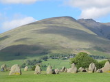
Taken from the Coate Water Country Park FB page:
"Coate boasts a host of Bronze Age, Romano-British and Medieval history that spans a period of up to about 3000 years. The oldest known ancient monuments at Coate are the Neolithic Stone Circle and the Bronze age burial mound along Day House Lane. However, no less than six Stone Circles have been recorded in the Coate area linked up, in part, by avenues of large Sarsen stones. The remains of one of the stone circles probably still lies at the bottom of the lake at Coate Water whilst other ancient finds are dotted around the area that include evidence of Medieval settlements."
|
Imbolc today, my favourite day of the year and the winter sun was shining in the promise of spring. Met up with my friend (who owns a car) and we headed off into the Cotswolds to Avening (passing through that parallel universe of Tetbury where no-one is poor, disabled, or in any way dishevelled).
Following the directions of thesweetcheat, Carl and Baza, we found the private road easily (about 200 metres past the local school) on the other side of the road. We quickly spotted the place where others have scrambled down the bank under the barbed wire - a bit steep but we went carefully. What a great surprise these two little chambered tombs are - the remains of a third also visible. Set into the bank they reminded me of some of the Irish wedge tombs in size. I've since learnt they had been moved from their original site - see Rhiannon's notes.
Seeing them for the first time without being aware that this was not their original location I have to say they seemed very 'settled' into the steep bankside, well camouflaged as they are by fallen leaves, soil and moss. A lovely spot overlooking what today was a fast flowing river.
|
Today, with an interlude of winter sun for about an hour.
A circular (triangular) walk from Upper Lambourn using OS map 170. Set off late morning along a surprisingly unmuddy byway as far as Postdown’s Farm from where we had to do some road walking. Clear signs of recent flooding, the adjacent fields were lake-like in places – we passed a couple of large round barrows on our left as we walked towards Seven Barrows Nature Reserve. The road was badly flooded by the entrance to the nature reserve and the entrance impassable on foot without wellies, fast flowing water running off into a nearby field (must be springs around here to cause to the water to flow such). We managed to jump across a water filled ditch and scramble under some blackthorn hedging to get a better look at the seven (possibly eight) barrows.
The landscape is astonishing – apparently 26 barrows in all dating back to 2200BC. We didn’t actually count the ones we saw besides the seven in the nature reserve but there were several. The sense of walking through an important Bronze Age cemetery was tangible.
We continued on foot along the road past Seven Barrows House and took the track towards Uffington to look for the long barrow shown on the OS map. Not much left and it would be easy to walk past if you didn’t know it was there as absorbed into a beech plantation – two fine stones remain though.
Picked up another muddy byway back to Upper Lambourn and happily came across the Hangman’s Stone just before the track back down to the village. A small standing stone approximately a metre high – probably a boundary stone.
|
Out walking yesterday - one of those November days that feels like a gift. Sunday, the rain lashed down. Monday, the sun came back and warmed the sodden earth. Had arranged to walk with my Gloucestershire walking friend who picked out a route that stuck to green paths where possible. We set off at from the little village of Yanworth (near Chedworth Roman villa) and walked to the village of Hampnett. Hangman's Stone is marked on the OS map about halfway between the two villages, just off the Salt Way and on the Macmillan Way. The stone itself lies on its side and is well camouflaged by the Cotswold stone wall behind it. Now in two parts with a hole through what looks like the top half. (Just read tsc's post which indicates the stone has always been two stones - to me it looked like one standing stone that had split naturally through weathering)
Curious this one - came upon it by chance and it doesn't really want to be seen.
|
|
I omitted to add this when I wrote up my fieldnotes on Gower. This atmospheric cairn is about 30 metres from Maen Ceti and the two sites seem connected. I don't know if there is any archaeological data concerning this cairn - it just seems to be in the right place. Stopped here for bit to enjoy the estuary view towards Llanelli. Anyone visiting Maen Ceti would feel naturally drawn to walk over to it.
|
Sunday 21st October 2012
The day started overcast but quickly turned into an amazing day full of blue sky and sea. Rhossili soon became very busy because of the lovely weather (surfers out in droves). Fortunately we had made an early start so avoided the crowds until later in the day. The plan was to walk to Hillend from Rhossili along the top of Rhossili Down and return along the beach (which I believe is the largest in the UK). Sweyne Howes burial chambers came into view at about the half way point of the walk - one is ruined with the stones scattered. The larger and more intact chamber is reminiscent of some of the wedge tombs I saw in Ireland. Unlike the wedge tombs, however, these two are hidden from the sea view being well below the high ridge of the Down.
|
Saturday 20th October 2012
Starting from Penmaen, three miles along the Gower Way - the walk along the top of Cefn Bryn made the visit to this astonishing site all the more memorable. It was a beautiful mid October morning - the sea visible on both sides. So much to see and enjoy, not least the free range Welsh ponies which galloped across the brown bracken.
Maen Ceti is astonishing - a massive capstone standing on several small stone 'legs' with a scatter of smaller stones around. The legs stand in water and the surrounding ground is boggy in places - I believe there are a few springs nearby. Close by too, is a large stone cairn (which felt related).
|
|
Passionate about:
Nature; stone circles and all ancient sites that involve walking through unspoilt countryside/being near the sea; islands around the the British Isles, especially those with ancient monuments.
|